Saturday, October 10, 2009

North OPS: WX Discussion - Severe Weather on the way Monday

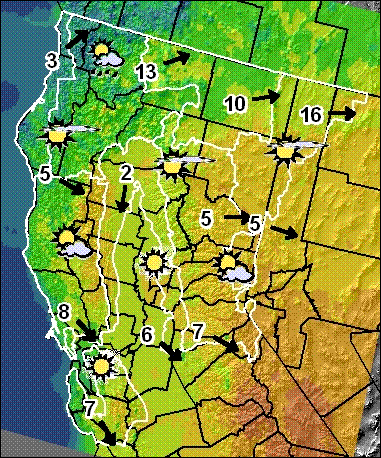
California North OPS Daily Weather Discussion - Prepared 0740 PDT Saturday Oct. 10, 2009

A high pressure ridge off the west coast will pass over the North Ops region on Sunday. On Monday low pressure following the ridge will begin to affect the region. Winds will increase out of the S-SW, gusting to 30-40 mph over higher terrain and wind-prone areas. Humidity will be higher and clouds will increase over the area, and by late afternoon scattered rain showers will develop in coastal areas. Rain and high elevation snow (6000 ft or higher) will spread across the entire region Monday night, and continue into early Wednesday before breaking up into scattered to isolated showers. A cool and humid SW-West flow will continue over the region through the weekend with a chance of rain each day in far NW CA.

Source: http://gacc.nifc.gov/oncc/predictive/weather/wxdisc.htm

Newport Beach firefighter suspected of killing of girlfriend's dog

LA HABRA – A Newport Beach firefighter is suspected of being responsible for the death of a girlfriend's dog Thursday evening.

The firefighter, who lives in La Habra with his girlfriend in the 300 block of Oakland Drive, is suspected of punching a 6-pound Chihuahua named Bella after it bit him.

Newport Beach Fire Department Chief Steve Lewis said that a private party had notified him of the situation concerning firefighter Aaron Reed, but that no action would be taken until official word comes from La Habra police.

Officer Rick Van Vleet of the La Habra Police Department, who handles animal control issues, would not identify the firefighter by name.

"We've confirmed that a Chihuahua bit a young man and that apparently he struck the dog," Van Vleet said. "The dog was injured and the vet put her to sleep. It's still under investigation."

At this point, Van Vleet said, it's still a dog-bite investigation, so the dog's body is being examined for rabies. After the rabies test, there will be a necropsy to determine cause of death.

Original source article: http://www.ocregister.com/articles/dog-firefighter-habra-2601251-vleet-investigation

More information:
http://www.justice4karley.com

Thursday, October 8, 2009

CAL FIRE Forestry: Magalia Reforestation Center seedling program

Tree Seedlings Available for Post-Fire Forest Restoration

Sacramento - California’s forest landowners are again experiencing the impacts of wildland fires on their property.
To assist those affected by wildfires, CAL FIRE has an assistance program that offers tree seedlings for reforestation.

The Tree Seedling Nursery Program grows and sells tree seedlings for reforesting burned-over
and understocked lands of small forest ownerships. CAL FIRE is growing a good inventory of
seedlings, but because of last year’s exceptionally severe fire season, demand may outpace the
supply.

Therefore, CAL FIRE is advising landowners to first check with the nursery staff to
determine what seedlings are available and to submit their orders early. The nursery will start
accepting orders on November 1, on a first-come, first-served basis. CAL FIRE staff also can
direct landowners to private nurseries that may have appropriate planting stock to meet their
needs.

The CAL FIRE Nursery Program has a staff of foresters who can provide free reforestation
advice to landowners. Additionally, CAL FIRE has Forestry Assistant Specialists at many local Unit Offices who can also provide free reforestation advice or direct individuals to the type of professional consultant they need to assist them.
These specialists also can provide information on State or Federal cost-share funding that may be available.

Seedling prices vary by age (one or two year old), how they are grown (bare root or in
containers) and by the quantity purchased. Seedlings grown cover the majority of California’s
timberland conifer species. Additionally a few hardwoods and non-native species are grown for specific landowner objectives.

All seedlings grown are from seed that is well adapted to the various climate zones, growing conditions and elevations found within the state. The seedlings are grown at the Magalia Reforestation Center east of Chico.

The 2009-2010 order form and price list will be available on line or by request after October 15, 2009.

For more information: please contact the Magalia Reforestation Center at 6640 Steiffer
Road, Magalia, 95954, Phone: (530) 872-6301, email: cdfnursery@fire.ca.gov.

To order seedlings go to www.fire.ca.gov and click on “Resource Management,” then “State Nurseries.”
News Release PDF Info: http://www.fire.ca.gov/communications/downloads/newsreleases/2009/NurseryNR.pdf

To contact a Forestry Assistance Specialist in your area click on “Forestry Assistance” then “Contact a Forest Advisor.”

CONTACT: Rich Eliot - Division Chief - Nursery Program
530-872-6301

Tuesday, October 6, 2009

Earthquake - 4.1 M - Lone Pine swarm continues


A light earthquake occurred at 11:06:34 AM (PDT) on Tuesday, October 6, 2009.
The magnitude 4.1 event occurred 8 km (5 miles) SSE of Keeler, CA.
The hypocentral depth is 0.2 km (0.1 miles).


Magnitude 4.1 - local magnitude (ML)
Time Tuesday, October 6, 2009 at 11:06:34 AM (PDT)
Tuesday, October 6, 2009 at 18:06:34 (UTC)
Distance from Keeler, CA - 8 km (5 miles) SSE (166 degrees)
Cartago, CA - 19 km (12 miles) NE (55 degrees)
Olancha, CA - 22 km (14 miles) NE (37 degrees)
Lone Pine, CA - 27 km (17 miles) SE (133 degrees)
Las Vegas, NV - 237 km (147 miles) W (277 degrees)
Coordinates 36 deg. 25.1 min. N (36.419N), 117 deg. 51.0 min. W (117.851W)
Depth 0.2 km (0.1 miles)
Location Quality Fair
Location Quality Parameters Nst=036, Nph=036, Dmin=15 km, Rmss=0.32 sec, Erho=0.6 km, Erzz=2 km, Gp=79.2 degrees
Event ID# ci14523676

CA-BEU- Ft. Ord (Rx Burn) Very Large Header, Prescribed burn on Fort Ord

CA-BEU- Ft. Ord (Rx Burn) Very Large Header, Prescribed burn on Fort Ord -> Cam link http://bit.ly/3fncCw

A prescribed burn on Fort Ord today was curtailed after less than two hours.

An Army information line said the burn in Burn Unit 14 started at 9:45 a.m.

A compliance officer with the Monterey Bay Regional Air Pollution Control District said the Army decided to shut the burn down about 11:15 a.m. "It is now in suppression mode," said Teresa Sewell of the air district.

There were unconfirmed reports that a shift in wind direction prompted the move to tamp down the burn.

The fires are used to clear brush in areas on the former base where there may be unexploded ordnance.

Sewell said the air district hadn't received any complaints about this morning's burn.

Monday, October 5, 2009

U.S.F.S Ranger loses homes, and animals in fires

One of the homes lost in Sheep fire was owned by Bobby Wright, the US Forest Service worker who was assaulted last month in Lytle Creek

Contributions may be made to the Lytle Creek Ranger Station, 1209 Lytle Creek Road, Lytle Creek, CA 92358. For more info call 909-382-2851
---------------------------

Friends say Bobby Wright is relying on faith to get him through his loss.

He doesn't have much else left.

The U.S. Forest Service employee lost his home Saturday during the Sheep Fire northwest of Lytle Creek.

The 20 dogs he had rescued died in their kennels as the flames roared up Lone Pine Canyon.

Less than a month ago, he was attacked and beaten while writing a parking citation in the course of his duties.

Six years ago, he lost his previous home in the Grand Prix Fire. That time, he was able to rescue the dogs before it was too late.

Wright, 63, had been living in a mobile home east of Lytle Creek for about two years. The property is at the end of Swarthout Canyon, a winding dirt road in High Desert terrain.

He had been helping with evacuations Saturday as the fire rampaged through thick brush toward his mobile home, his dog kennels and his co-worker's horse stable.

Wright tried to get home to rescue the animals, but his co-worker and friend, Forest Protection Officer Jack Kennedy, decided it was too dangerous.

"I was tempted to let him go back in there, but the flames were moving so fast, we both would have been killed," Kennedy said. "The flames were swirling like a tornado and sounded like a railroad."

A helicopter was able to douse Kennedy's barn, sparing the horse, but Wright's dogs couldn't be saved.

"This was the second time he lost everything he owns," Kennedy said.

Kennedy, who lives in Wrightwood, offered him a place to stay Saturday night, but Sunday the town was evacuated.

Wright returned to the charred rubble of his property Sunday to bury his dogs. He could not be reached for comment Sunday.

Six years ago, Wright was living in the Middle Fork area of Lytle Creek when the Grand Prix Fire swept through and left his home in ruins.

Kennedy said Wright then lived in a church until two years ago.

After losing his Lytle Creek home, Wright got a job as a Forest Service recreation technician, patrolling forest land and checking for violations, Kennedy said.

On Aug. 31, Wright was writing a $5 citation for illegal parking at Applewhite Campground near Lytle Creek when he was hit from behind, kicked and beaten. He didn't realize he had been mugged until he arrived at the hospital, Kennedy said.

One man has been arrested in the attack, and warrants have been issued for two others.

As a seasonal employee, Wright had been scheduled to be laid off in the coming weeks, but the Forest Service has guaranteed he will have a year-round job.

"He doesn't know what to do. He has nowhere to go," Kennedy said. "Right now he's holding on to his faith."

Forest Service employees are taking donations to assist Wright in recovering from the fire.

Contributions may be made to the Lytle Creek Ranger Station, 1209 Lytle Creek Road, Lytle Creek, CA 92358. For more information, call 909-382-2851.

Source: PE.com - Link

Sunday, October 4, 2009

ALL STATE FLAGS TO BE FLOWN AT HALF-MAST TODAY

In honor of State & National Fallen Fire Fighter Memorials today.


October 2 - 4, 2009
28th National Fallen Firefighters Memorial Weekend
A plaque with the names of 103 firefighters who died in the line of duty in 2008 will be added to the National
Fallen Firefighters Memorial. The names of 19 firefighters who died in previous years will also be added.

Visit the Main FireHero.org Website
or
Visit the Memorial Weekend Website


CA-BDF- Sheep 7,128 acres and is 90% contaned.

Sheep Firestorm - Wrightwood CaliforniaSheep Firestorm - Wrightwood California
Credit: Mike Meadows
Sheep Fire Satellite Map and Fire PerimetersSheep Fire Satellite Map and Fire Perimeters

The evacuation of Wrightwood was lifted at 1200hrs today. Highway 2 to Wrightwood was reopened at 1200hrs today. The evacuation center at the San Bernardino Fair Grounds has been closed. The Eishenhower High School Evacuation Center will remain open. T

Road Closures: The evacuation of Wrightwood was lifted at 1200hrs today. Highway 2 to Wrightwood was reopened at 1200hrs today.
-------------------------------------------------
Update: 10-09-09 0800hrs - Sheep Fire: CA-BDF- Sheep 7,128 acres & 90% cont. Aggressive mop-up & fire suppression repair resulted large demobilization of resources.
Update: 10-08-09 0800hrs - Sheep CA BDF- 13278 SOCAL CIIMT Team #2 (Woychak) remains in command of the incident. Incident remains 7,128 acres and is 85 percent contained. Minimal fire activity and freezing temperatures were observed in the last operations period. The fire continues to smoldering in debris with some creeping. A"sheep fire" closure document has been approved limiting travel through and around the San Bernardino NF. The following road closures are in effect per San Bernardino national forest sheep fire closure area document and are listed as follows; Lytle creek road 3n06 is open up to end of pavement. Closure area begins at the south end of sheep canyon, then continues northwest to Mormon rocks, then continues west to circle mountain, then continues south to gobbler’s knob, then back to the starting point. 882 firefighters remain assigned. Included in closure is Forest rd 3no6, from the unpaved portion at the Lytle Creek shooting area, then west to its termination. Forest service rd 3n35. Pct from interstate 15 to San Bernardino national forest western boundary. These roads are closed except for owners or lessees of land within the area, permitted individuals, and any federal, state, or local officer, or member of an organized rescue or firefighting force in the performance of an official duty.

Update: 10-06-09 1800hrs -Sheep CA-BDF-13278 Incident is 7,128 acres and is 75% contained.
Minimal fire activity was observed today, with isolated torching of interior islands, creeping fire & smoldering.
The incident has been taken out of Unified Command. The projected containment date has been moved to 10/10/09 due to access and terrain difficulties.
There were four minor injuries reported this operational period. Continuing extensive mop-up of numerous heat sources. Total personnel assigned is 1,890.

Update: 10-06-09 0800hrs - Sheep CA-BDF-13278 Incident is 7,128 acres and is 32% contained. Due to favorable weather conditions, minimal fire activity was observed last night.

The evacuation of the community of Wrightwood is still in progress. Lone Pine Canyon Road and Highway 2 remain closed. As of 1900 hrs last night, Highway 138 was opened to the public. Lytle Creek was opened to residents only.

Road closures include Lone Pine Canyon Rd, Swarthout Canyon, and Highway 2. Evacuation centers include San Bernardino County Fair Grounds and Eisenhower High School.

The Damage Inspection Team has completed its final report. Acreage change is due to more accurate mapping. Total personnel assigned is 1,947.

Update: 10-05-09 1800hrs - Sheep CA-BDF-13278 Incident is 7,824 acres and 30% contained. Due to favorable weather conditions, minimal fire activity was observed today. The fire was mainly a creeping fire and smoldering.

The evacuation of the community of Wrightwood is still in progress.
Road closures include Lone Pine Canyon Rd, Swarthout Canyon, and Highway 2. Lone Pine Cyn Rd and Highway 2 remain closed. As of 1900 hrs today, Highway 138 was opened to the public. Lytle Creek was opened to residents only.

Unified Command continues with SOCAL IMT 2, San Bernardino County Fire Department and San Bernardino Sheriff. ICP is at Glen Helen Regional Park. A Damage Inspection Team is currently working on the incident. There were two minor injuries reported today. (1- minor burn & 1- minor hand injury) . Total personnel assigned is 1,715.

Evacuation centers include San Bernardino County Fair Grounds and Eisenhower High School. Large animals are being accommodated at the Victorville Fairgrounds and Small animals are being taken to Devore Animal Control.

Update: 10-05-09 0800hrs - Sheep CA-BDF-13278 Incident is 7,500 acres and 20% contained.
Extreme fire behavior with rapid rates of spread were observed during the night operations..
Firefighters are cautiously optimistic at this time about keeping the fire from burning into Wrightwood, in addition to the West Cajon Valley between I15 and Hwy 2. Crews are constructing direct fire line and numerous engine strike teams are in place for structure protection for the eastern portions of Wrightwood.
A community meeting was held last night for residents to learn more about the fire at the Lytle Creek Community Center. Another community meeting was also held at 8:00 PM at the Victorville Fairgrounds.
Current Weather Temp 35 degrees Humidity: 70% Wind NE with peak gusts of 6 MPH . Forecasted weather is temp. 56 degrees, humidity 18, wind speed of 10 with gusts to 20 from the SW. Total personnel assigned is 1,296.
Update: 0930hrs - Full evacuation of Wrightwood has been ordered.
Scanner transcription, "We've just been advised that we will be doing a full evacuation of the community of Wrightwood. Team 7 Everything East of Oak Street; Oak Street will be your western edge; everything south of Highway 2, east of Oak Street; Team 8 Division B going to have everything East of L street all the way over to Oak Street."
Update: 0900hrs - All of Wrightwood is under mandatory evacuations. Aircraft still grounded due to winds, Fire is un-contained.
Update: 0800hrs - 3,500 acres, 3 homes destroyed, Highway 138 and Highway 2 closed, 1 FF heat related injury yesterday.
Update: 0700hrs - Structure protection is on White 3 154.295., 55 engines enroute Code 3 to I-15 and 138 at the ICP.
Update: 0530 hrs - Fire is approximately 3500 acres @10% contained. Fire is buring is a mix of timber and chaparral. Fire is currently moving north to northwest from Swarthout Canyon to Highway 138.
Update: 1600+acres SoCal Team 2 (Woychak) has been activated for the fire.
Update: 10-5-09 0400hrs - Fire has exploded. - Fire has hit the trigger point for Wrightwood. Mandatory evacuations have been ordered and reverse 911 is in progress.
Update: : Structures reported threatened in Lytle Creek with approximately 100 residents being asked to evacuate.

Location:
ICP: CA-BDF- Sheep ICP138 and Highway 15
Initial Sizeup: Medium brush with a potential for 4000 acres - Swarthout Canyon Lytle creek area San Bernardino County.
Resources: 34 handcrews, 125 engines, 4 dozers, 9 water tenders.
Ground:
Air: Aircraft - on deck this morning, 6 helicopters and 11 airtankers (including the DC-10 and the Martin Mars).
Comms: Command BDF Local, NIFC Tac 1, NIFC Tac 2
Saturday, October 3, 2009

Earthquake - 3.0 M - Swarm continues

Magnitude 3.1 - local magnitude (ML)
Time Saturday, October 3, 2009 at 9:22:32 AM (PDT)
Saturday, October 3, 2009 at 16:22:32 (UTC)
Distance from Keeler, CA - 11 km (7 miles) S (182 degrees)
Cartago, CA - 15 km (10 miles) ENE (61 degrees)
Olancha, CA - 18 km (11 miles) NE (39 degrees)
Lone Pine, CA - 28 km (18 miles) SE (142 degrees)
Las Vegas, NV - 239 km (148 miles) W (276 degrees)
Coordinates 36 deg. 23.2 min. N (36.386N), 117 deg. 52.6 min. W (117.876W)
Depth 4.3 km (2.7 miles)
Location Quality Fair
Location Quality Parameters Nst=039, Nph=039, Dmin=19 km, Rmss=0.33 sec, Erho=0.5 km, Erzz=2.6 km, Gp=79.2 degrees
Event ID# ci14521148


Magnitude 3.0 - local magnitude (ML)
Time Saturday, October 3, 2009 at 8:10:35 AM (PDT)
Saturday, October 3, 2009 at 15:10:35 (UTC)
Distance from Keeler, CA - 11 km (7 miles) S (181 degrees)
Cartago, CA - 15 km (10 miles) ENE (61 degrees)
Olancha, CA - 18 km (11 miles) NE (39 degrees)
Lone Pine, CA - 28 km (18 miles) SE (142 degrees)
Las Vegas, NV - 239 km (148 miles) W (276 degrees)
Coordinates 36 deg. 23.1 min. N (36.386N), 117 deg. 52.5 min. W (117.875W)
Depth 0.3 km (0.2 miles)
Location Quality Fair
Location Quality Parameters Nst=038, Nph=038, Dmin=19 km, Rmss=0.31 sec, Erho=0.5 km, Erzz=1.3 km, Gp=79.2 degrees
Event ID# ci14521076

Friday, October 2, 2009

Earthquake - 4.7 M - 6 miles S of Keeler, CA.


This event has been reviewed by a seismologist.

A light earthquake occurred at 10:31:57 PM (PDT) on Friday, October 2, 2009.
The magnitude 4.7 event occurred 10 km (6 miles) S of Keeler, CA.
The hypocentral depth is 2 km ( 1 mile).


Magnitude 4.7 - local magnitude (ML)
Time Friday, October 2, 2009 at 10:31:57 PM (PDT)
Saturday, October 3, 2009 at 5:31:57 (UTC)
Distance from Keeler, CA - 10 km (6 miles) S (178 degrees)
Cartago, CA - 16 km (10 miles) ENE (59 degrees)
Olancha, CA - 19 km (12 miles) NE (38 degrees)
Lone Pine, CA - 28 km (17 miles) SE (140 degrees)
Las Vegas, NV - 238 km (148 miles) W (276 degrees)
Coordinates 36 deg. 23.7 min. N (36.395N), 117 deg. 52.1 min. W (117.869W)
Depth 1.6 km (1.0 miles)
Location Quality Fair
Location Quality Parameters Nst=034, Nph=034, Dmin=18 km, Rmss=0.26 sec, Erho=0.6 km, Erzz=1.7 km, Gp=79.2 degrees
Event ID# ci14520476
Additional Information map with fault names
Google Earth KML (Requires Google Earth.)
Did you feel it?
Waveforms
24-hour Aftershock Forecast Map

Twitter Buttons

****REMINDER**** Every fire has the ability to be catastrophic. The wildland fire management environment has profoundly changed. Growing numbers of communities, across the nation, are experiencing longer fire seasons; more frequent, bigger, and more severe, fires are a real threat. Be careful with all campfires and equipment.

"I am a firm believer in the people. If given the truth, they can be depended upon to meet any national crisis. The great point is to bring them the real facts, and beer." --Abraham Lincoln

View blog top tags
---------------------
CLICK HERE TO GO BACK TO TOP OF CALIFORNIA FIRE NEWS HOME PAGE

Subscribe via email to California Fire News - Keep track of Cal Fire News

Enter your email address:

Delivered by FeedBurner