Friday, October 31, 2014

Virgin Galactic's #SpaceShipTwo Crashes In Mojave Desert: 1 Pilot Dead, 1 Injured

Space tourism Virgin Galactic’s SpaceShipTwo rocket plane explodes at 45,000 Feet


Virgin Galactic’s SpaceShipTwo rocket plane exploded and crashed during a test flight on Friday, killing one crew member and seriously injuring another, authorities said.

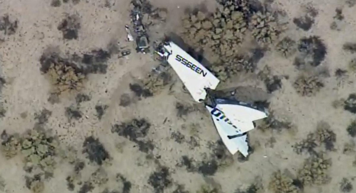
The  Scaled Composites Model 339 SpaceShipTwo explosion came after the plane dropped away from its WhiteKnightTwo carrier airplane and fired up its hybrid rocket engine, said Stuart Witt, CEO and general manager of the Mojave Air and Space Port in California. The blast scattered debris across a two-mile swath of the desert floor north of Mojave, which is about 95 miles (150 kilometers) outside Los Angeles.


"We hope that the survivor will be just fine," Youngblood said during a news briefing.

The pilots have not yet been identified, but both of them worked for Mojave-based Scaled Composites, according to Scaled's president, Kevin Mickey. Scaled has played a key role in developing and testing SpaceShipTwo for Virgin Galactic.

Virgin Galactic had planned to use this SpaceShipTwo to fly passengers on suborbital trips to the edge of space, beginning as early as next year. A nearly identical rocket plane is already under construction inside a Mojave hangar. More than 700 customers, including celebrities such as Ashton Kutcher and Justin Bieber, have paid as much as $250,000 to take a ride.

First powered flight in months

SpaceShipTwo's crew was testing the rocket engine in flight for the first time in more than nine months. The plane was slung beneath WhiteKnightTwo for takeoff from the Mojave Air and Space Port at about 9:20 a.m. PT (12:20 p.m. ET). When the paired planes reached a height of about 50,000 feet, about 40 minutes later, SpaceShipTwo was released for the test.
Witt said the anomaly occurred about two minutes after SpaceShipTwo dropped away and fired the rocket engine, but he didn't see any explosion. "It wasn't because something did happen. It was what I was not hearing and notseeing," Witt said.
Photographer Ken Brown, who was covering the test flight, told NBC News that he saw an explosion high in the air and later came upon SpaceShipTwo debris scattered across a small area of the desert. The WhiteKnightTwo plane and its pilots, meanwhile, landed safely.
Authorities cordoned off the crash site pending an investigation. A National Transportation Safety Board team was expected to get to the crash site Saturday morning. The Federal Aviation Administration said it was also investigating the incident.
Mickey said he expected that the investigation would take several days.
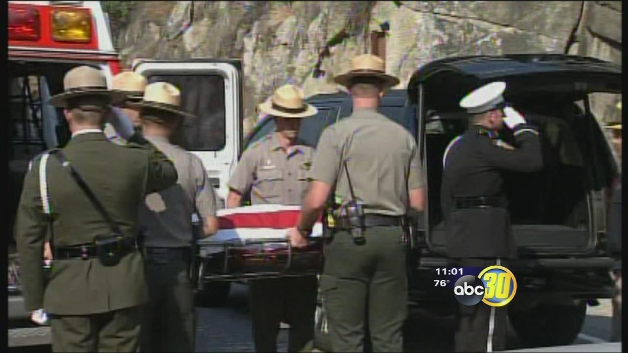
One of the two test pilots aboard the plane was killed, said Kern County Sheriff Donny Youngblood, who was among the officials dealing with the crash's aftermath.
The other parachuted to the ground and was injured. That pilot was transferred to Antelope Valley Hospital in Lancaster, California, according to Kern County Deputy Fire Chief Michael Cody.
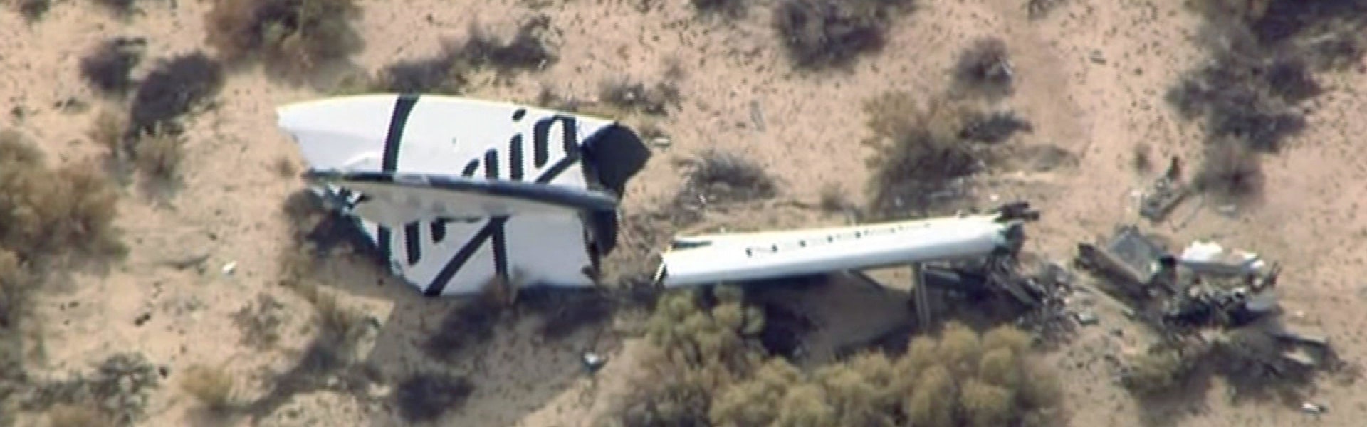
Virgin Galactic's SpaceShipTwo  Mojave Desert Crash Site
Credit: Image from video by KABC TV Los Angeles shows wreckage of what is believed to be SpaceShipTwo in Southern California'son Friday, Oct. 31, 2014. 
The explosion of Virgin Galactic's passenger rocket is stirring up mixed emotions as scientists and others involved in the space industry wait for more details on what happened over the Mojave Desert on Friday.

Here is some of the reaction to the crash:


— Former NASA top space scientist Alan Stern has seats to fly on Virgin Galactic — and its competitor XCOR aerospace. He isn't rethinking plans to fly in space at all.


"Let's not be chicken Littles here," said Stern, now a vice president at Southwest Research Institute. "The birth of aviation was also a very dangerous time period."


"All forms of transportation carry risk," he said. "To expect spaceflight could somehow be different is unrealistic on the part of the public or anyone. Secondly to do something very hard, to do something on the frontier, comes with risk."


— Eric Stallmer, the president of the Commercial Spaceflight Federation, offered his sympathies to the families affected by the explosion.


"Today, we are tragically reminded of the tremendous challenges that we face every day in our efforts to push the envelope of human experience and capability in space enterprise and exploration," he said.


Stallmer and Bill Nye, chief executive of the Planetary Society, said the courage of both pilots and the commitment Virgin Galactic has made to space tourism will serve as inspiration as the industry continues to make space travel as safe and reliable as possible.


— Former NASA astronaut Jerry Linenger, who nearly died in a 1997 fire aboard the Russian space station Mir, said when he first met British billionaire Richard Branson, founder of Virgin Galactic, he told him the first thing he'd have to worry about is liability insurance.


"You will have setbacks," Linenger said he told Branson. "That is a reality."


— In New Mexico, from where Virgin Galactic planned to launch its tourism rockets within the next year, hearts were sinking. The New Mexico Spaceport Authority issued a statement saying it was sending its thoughts and prayers out to the crew's family members and the team that has been working for years to develop the rocket.


"We will continue to work with and lend our support to Virgin Galactic through this tragedy and in the coming months as we move forward," the authority said.


Several people expressed sadness that one pilot was killed and another was seriously injured, many also said they understand the risks that come with pushing the boundaries that have hampered the burgeoning commercial space travel industry.


SpaceShipTwo Facts
The Scaled Composites Model 339 SpaceShipTwo is a suborbital, air-launched spaceplane designed for space tourism.Wikipedia

First flight: October 10, 2010
Top speed: 2,485 mph (4,000 km/h)
Wingspan: 27' (8.20 m)
Length: 60' (18 m)
Engine type: RocketMotorTwo
Manufacturer: Scaled Composites
Designer: Scaled Composites---------------------------------------------

CA-YNP Yosemite Fires Dog Rock Fire and Meadow Fire

Yosemite Fire Update October 30, 2014
Update #26

DOG ROCK FIRE 


Current Situation: Fire crews have completed rehabilitation of the fire area. The fire is at 311 acres, and with 100 % containment. Firefighters and fire engines will be patrolling Hwy 140, watching for rolling material and hotspots. Travelers should use extreme caution and expect delays when driving through the fire area. Smoke from the interior of the fire may be visible.

MEADOW FIRE
MEADOW FIRE FIRE PERIMETER MAP
37 42.738 x 119 30.541 – Mariposa Co., 7,870’, August 16). The fire is at 4,772 acres and 98% containment. Smoke continues to show occasional smoke from the interior of the fire perimeter. It is now in a monitoring status. Until further notice, the only trail open in the Little Yosemite Valley area is the Half Dome access trail from Nevada Falls. The Little Yosemite Valley campground has been re-opened.
Additional Fires 
Cathedral (37 51.843 x 119 23.720 – Tuolumne Co., 9,140’, July 16) This fire is now at 22 acres and continues to smolder and creep through surface fuels. It is northeast of Cathedral Peak. Smoke is occasionally seen from locations within Tuolumne Meadows.

Lembert (37 53.159 x 119 19.059 – Tuolumne Co., 9,250’, July 16) This fire is at 4 acres and continues to smolder and creep through surface fuels in a lodgepole pine forest. It is east of Lembert Dome. Smoke is periodically visible from locations in Tuolumne Meadows

Double Rock (37 54.616 x 119 35.025 - Tuolumne Co., 8,800’, found September 18) This high elevation fire, burning since July has been declared out. 

Closed Trails: The John Muir Trail between the Clouds Rest Junction and Sunrise High Sierra Camp.
Sunrise trail to Clouds Rest from Tenaya Lake through to the John Muir Trail
Clouds Rest
The trail along the Merced River between Little Yosemite Valley and Echo Valley.

Air Quality: Although air quality has improved, smoke may continue to be visible from the Meadow, Lembert and Cathedral Fires.

For More Information
Fire information: gary_wuchner@nps.gov, (209) 372-0480.
For wilderness access and trail closure details and questions please call (209) 372-0826.
For Yosemite air quality data and webcams: www.nps.gov/yose/naturescience/aqmonitoring.htm
For smoke updates: www.californiasmokeinfo.blogspot.com
Yosemite National Park Web page: http://www.nps.gov/yose/blogs/fireinfo.htm
Yosemite Wildland Fire Facebook: 
https://www.facebook.com/pages/Yosemite-Wildland-Fire/124632964255395

As with any fire incident in Yosemite National Park, firefighter and public safety is our number one priority. We appreciate everyone’s assistance with this priority

---------------------------------------------

Sunday, October 19, 2014

APPOINTMENT OF DESIREE HORTON AND WAYNE KRAGER TO CAL FIRE FORESTRY FIRE PILOT

I am very pleased to announce the appointment of Desiree Horton and Wayne Krager to Forestry Fire Pilot, assigned to Prado Helitack Base in the San Bernardino, Inyo, Mono Unit. This permanent appointment will be effective on October 6, 2014.

Desiree Horton
Desiree Horton is a native of Southern California and was exposed to helicopters at an early age. After graduating from North Hollywood High School she went straight into flying. She spent years and countless jobs working double and triple shifts to pay for lessons and training. She spent the next 24 years flying such missions from tours, aerial photo shoots, traffic watch, news gathering for all of the Los Angeles stations, pilot/reporter for KABC, KTLA, KNBC, KCBS, and KCAL in Los Angeles, movie production flying, on camera flying for films and documentaries, frost patrol, organ donor transplant team flights, corporate, private, government, and celebrity charter, animal heard head count flights, land survey, power line patrol, heavy lift construction, police contract for Corona Police Department, USFS fire contracts, heli-ski, seismic, car race chase support annually including such races as the Baja 1000 in Mexico. Prior to coming on with CAL FIRE last year as an LT, she spent the previous 9 years flying fire contracts all over the California and the U.S. for various companies with the end goal to be a fire pilot for CAL FIRE.


 To stay proficient with her utility and mountain flying skills outside of fire season, Desiree flew heavy lift construction all over the Midwest and Heli-ski and seismic in Utah during the winter months. Desiree was hired on with CAL FIRE as a Limited Term Pilot in March of 2013 and was based up at Kneeland until coming to the Prado Helitack as of January 1, 2014. Desiree said “I am very excited to have been a part of starting the new firefighter 1 program at Prado and look forward to the rest of my life and career here in the Unit with Prado Helitack and the entire CAL FIRE family.”


Wayne Krager was raised in Southern California, and always had an interest in law enforcement, firefighting, and aviation. Wayne graduated from Cal State Los Angeles with a Bachelor’s degree in Aviation Administration in the fall of 1992. During his last years in college, Wayne earned his private pilot helicopter rating in 1992. It was at this time he decided to join the Army on the delayed entry program to become a Warrant Officer Helicopter pilot. Having served 7.5 years in the Army as a UH-1 Huey pilot Wayne decided to leave the Army and become a Deputy Sheriff of San Bernardino County in hopes of becoming a pilot with them. After completing the Sheriff Academy in December of 2001 and working in the jail, Wayne was asked to join the Aviation Unit. During his tenure with the Sheriff department assigned to Prado on a contractual basis, Wayne knew he wanted to fly permanently for Cal Fire. After serving 13 years with the County plus the 7.5 with the Army, he gained valuable knowledge and experience which would help me obtain my goal of flying for Cal Fire. Wayne stated “Through dedication and hard work, along with the support of my very loving wife and family members, I am now firefighting as a helicopter pilot for Cal Fire back flying 305 at Prado. I’m very blessed and honored to have been chosen for this position.”

We are glad to have such highly dedicated, qualified Pilot’s as well as good people in our Prado Helitack Program. 


Please join me in congratulating Desiree and Wayne and welcome them into the BDU/ CAL FIRE Family.---------------------------------------------

CVFF Charity Golf Classic to Benefit the Chula Vista Fire Explorers program. #CaFire

CVFF Charity Golf Classic


The Chula Vista Firefighter's Foundation (CVFF) is holding its Annual Charity Golf Classic at Salt Creek Golf Course on Friday, November 7th. All Local 2180 members and their family and friends are encouraged to play in this year's tournament. All proceeds from the tournament will benefit the Chula Vista Fire Explorers program. This is the CVFF's biggest fundraiser of the year and provides much of the funding for the Fire Explorer program. The cost per player is $125 ($500 per foursome), but will go up after Halloween so register early. With your registration you get a round of golf, a cart rental, breakfast, lunch, dinner, ample hydration, golf schwag, and much more.

Players can register online this year. Please go to the CVFF Golf registration page for more information and to register your team.

Please direct any questions about the tournament to Matt D'Amico, Jeff Ewert, Josh Sanders, Pablo Ornelas or Dangkhoa Nguyen.
---------------------------------------------

CAL FIRE LODD MEMORIAL SERVICE Airtanker Pilot Geoffrey “Craig” Hunt #CaFire

 GEOFFREY “CRAIG” HUNT

“My dad died a hero. There was not a day that went by that I didn't talk to my dad. He was my best friend”, Sarah Hunt Lauterbach.
GEOFFREY “CRAIG” HUNT
CAL FIRE Plans Memorial Service for Airtanker Pilot

San Jose – Firefighters will gather together to pay their respects to Airtanker Pilot Geoffrey “Craig” Hunt as well as to his family, who paid the ultimate sacrifice with his life while fighting the Dog Rock fire near El Portal, California. A celebration of Craig’s life, with a full Line of Duty Death fire service honors, will take place Tuesday, October 21, 2014 at 10 a.m.

On October 7, 2014, Dyncorp Pilot Geoffrey “Craig” Hunt was involved in a fatal crash while flying a CAL FIRE S-2T Airtanker over the Dog Rock fire burning near Yosemite’s Arch Rock. “We continue to mourn the tragic loss of Craig.” said Chief Ken Pimlott, CAL FIRE Director. “We know Wildland firefighting is an inherently dangerous job, but Craig made the ultimate sacrifice.”

“Our thoughts and prayers are with the pilot’s family during this difficult time,” said Jeff Cavarra, program director for DynCorp International.

Geoffrey ”Craig” Hunt was born October 14, 1951 in Richmond, IN. He is survived by his wife, Sally, whom he married in September of 1975, and his two daughters, Nancy Hunt and Sarah Hunt Lauterbach. Hunt served as a US Navy P3 pilot from 1975-1984 and was in the reserves for 20 years. Hunt earned a Masters in Business as well as in Biochemistry and was a chemistry teacher in the off season at the University of Santa Cruz. He had a love for flying, golfing, fishing, hiking, bird watching, scuba diving, math/sciences, teaching and dogs.

Memorial Service


Location: Church on the Hill, 500 Sands Dr., San Jose, CA 95125
Date: Tuesday, October 21, 2014 at 10 a.m.
Attire: Uniformed personnel is to be either Department Class A Uniform or Work Uniform with tie.
Public Safety Departments or Agencies that wish to attend or send apparatus for the memorial static display, please click here. Please arrive at the church by 9:00 a.m. for set up.
Media representatives that plan to attend the memorial service, please RSVP here. There will be a media briefing, day of, at the church at 9:15 a.m.

Cards can be sent to the family in care of:
The Hunt Family
c/o CAL FIRE Firefighters Local 2881
1731 J Street, Ste. 100
Sacramento, CA 95811

In lieu of flowers donations can be made to:
Craig Hunt Memorial Fund

Ashville School
360 Ashville School Road
Ashville, NC 28806
This fund will be designated for scholarship and athletics at the Ashville School.

Contact: Tom Marberger at (828) 254-6345 ext. 4081

CAL FIRE Local 2881 PRESIDENT’S MESSAGE OCTOBER 8, 2014

Brothers and Sisters,

Unfortunately, we work in a profession where there are going to be terrible reminders of the constant dangers associated with protecting lives and property. As you know by now, CAL FIRE Tanker 81 tragically crashed yesterday while battling the Dog Rock Fire near Yosemite National Park. The plane reportedly went down near the Dog Rock Fire within a mile from the park’s western entrance. Last night CAL FIRE, U.S. Forest Service and rescue crews hiked through extremely rugged terrain to reach the wreckage and confirm the death of the pilot. At this time, the family asked for an opportunity to make notifications to family members before his name is released publicly.

Our lost pilot is a 13 year veteran and is an employee of DynCorp., a contractor that provides the pilots for all CAL FIRE air tankers. Make no mistake about it, he was one of ours and his loss is deeply personal for all firefighters. CAL FIRE Local2881 will be treating this as a Type I funeral; the pilot will be honored for sacrificing his life for the safety of the community and fellow firefighters. He was a man of extraordinary skill and talent and he will be missed by those who worked with him and those who loved him.

The term “Fire Season” no longer holds true for the men and women of CAL FIRE. The way we fight fires are a way of life throughout the year. Even if the rains come early which is not expected, the job we do is done on a daily basis 365 days year. Whether you work in the San Diego Unit on a truck company or in Siskiyou on a Type III, CAL FIRE and its partners never leaves the front lines and are always available to answer a call for help from the people of California.

Again, fire dangers are far from over so please take care of yourself and others. You are important, and your safety matters to family, friends, colleagues and the communities we protect.

Please keep our lost firefighter, and his family, in your prayers.

Fraternally,
Mike Lopez
Contact CAL FIRE Local 2881
P:(916) 609-8700 | F:(916) 609-8711

---------------------------------------------

Monday, October 13, 2014

Eldorado National Forest King Post-Fire Burned Area Emergency Response (BAER MAP)


Eldorado National Forest King Post-Fire BAER Assessment


FIRE INTENSITY EFFECTS ON VEGETATION vs. FIRE SEVERITY EFFECTS ON SOILS


KING FIRE BAER MAP Eldorado National Forest
King Fire Burned Area Emergency Response Map


There are several types of fire severity maps that you may see. Although they look different for the same fire, they may also all be accurate. This is because fire severity is a measure of the fire effects on a specific resource such as soils, tree canopies, vegetation or wildlife habitat. Burned Area Emergency Response (BAER) maps are primarily measures of fire effects on soils. The following is a description of BAER fire severity mapping for soil burn severity levels.


SOIL BURN SEVERITY RATING OVERVIEW:
High Soil Burn Severity Rating: (severe damage to the soils): deeply burned soils with high water repellent soils (tend to be places where the fire burned the forest canopy, ground cover, roots, and organic matter in the topsoil).

Moderate Soil Burn Severity Rating: burned soil with moderate water repellent soils (much of the root, soil structure, and organic matter stayed intact and could help buffer the rainstorms that could cause erosion) can produce increased water run-off and soil erosion depending on the timing, magnitude, and duration of future precipitation. The remaining vegetation could quickly re-sprout and provide some cover from dead needles and leaf fall to reduce erosion.

Low Soil Burn Severity Rating: light soil burning includes land that may have burned in recent occurrences with brush or young timber growing on it.

KEY MESSAGES:

Wildfire does not always impact soils and vegetation in the same way.

A hot, fast moving fire (wind driven) can consume the majority of vegetation (especially when dry with low fuel moistures) in a burned area and can be classified as a high intensity fire area by fire ecologists/fire behavior analysts, but moves through so quickly that the soils remain largely intact.

When the duration (also described as residency time) of the fire is short (fast moving-wind driven), it can result in a low-to-moderate soil burn severity rating by BAER soils scientists because the soil did not get a lot of lingering heat on the ground.

Fire severity is a measure of the effects of fire on a defined resource.

All fire severity maps view landscapes from different perspectives, so various maps of the same fire can look very different, and all be accurate.

The BAER soil burn severity (SBS) maps specifically focus on severity to soils and watersheds.

There are also a number of other types of fire severity maps – many of which focus on different aspects of vegetation such as, Burned Area Reflectance Classification (BARC) and Vegetation severity maps are both vegetation maps but will also look different for the same location and time.
Vegetation severity maps also come from a number of different perspectives, and can be short-term or long-term views.

The correlation between fire intensity and soil burn severity is not always direct because the amount of heat generated and time duration both plays a critical role in the fire effects to soil.
Ground cover refers to the organic material on the top of the soil layer, and includes vegetative litter, duff, and woody debris/fuel.

When a fire slowly consumes fuel (long residence time), the fire (soil burn) severity is usually high.
When organic material within the ground cover and within the soil structure burns at high intensity, some of the water repellent components vaporize, and condense on the soil at the surface or deeper depending on the severity of the fire.
Because of the variability of fuel consumption, soil heating typically is non-uniform across landscapes.

During post-fire assessments, the BAER team uses the term “soil burn severity” to differentiate post-fire soil properties from fire effects on vegetation (such as tree mortality), and/or general fire effects on the long-term ecosystem health.
Soil scientists evaluate preliminary burn maps from satellite imagery to determine the effects and create a soil burn severity map.
Hydrologists use that information to model storm runoff over the burned area to estimate potential flood impacts to lives and property.
Foresters use the same satellite images to create a different map that displays post-fire impacts to the trees.

Source Info: http://inciweb.nwcg.gov/incident/4126/
---------------------------------------------

Wednesday, October 8, 2014

CAL FIRE announced name of crashed S-2T air tanker 81 pilot Geoffrey "Craig" Hunt CAL FIRE Pilot for 13 Years.

CAL FIRE has announced the name of the S-2T air tanker pilot that crashed while fighting the Dog Rock Fire in Yosemite National Park in California.

Geoffrey "Craig" Hunt was a CAL FIRE Pilot for 13 Years.

“With great sadness, the CAL FIRE NEWS and wildand community would like to express its deepest condolences to CAL FIRE for the loss of pilot, Geoffrey “Craig” Hunt Yesterday.
 He died serving and protecting the public from wildland fire. As members of the wildland firefighting community, we also mourn his loss and our thoughts are with his family and loved ones.”

#DogRockFire Suppression Efforts Continue in Yosemite National Park
---------------------------------------------

CAL FIRE S-2T Air Tanker 81 Pilot Has Been Removed From Yosemite Park Wreckage and Transported By Honor Guard #DogRockFire

 CAL FIRE has announced that an S-2T air tanker has crashed killing the contract pilot while fighting the Dog Rock Fire in Yosemite National Park in California.

An air tanker AT-81 fighting a wildfire near Yosemite National Park in Northern California smashed into a steep canyon wall Tuesday, killing the contract Dyncorp pilot, who was believed to be the only person aboard, officials said. No injuries reported by nearby fire crews on the ground.

The Pilots body was recovered yesterday and transported by honor guard this morning at 1100 hrs.

Honor guard removes pilot from crash site
 Respect For Your Service, Duty and Honor Sir...
---------------------------------------------

Tuesday, October 7, 2014

LODD: Pilot of S2T Air Tanker 81 Fighting Yosemite National Park #DogRockFire Reported Dead After Crash

 CAL FIRE has announced that an S-2T air tanker has crashed killing the contract pilot while fighting the Dog Rock Fire in Yosemite National Park in California.

An air tanker fighting a wildfire near Yosemite National Park in Northern California smashed into a steep canyon wall Tuesday, killing the contract Dyncorp pilot, who was believed to be the only person aboard, officials said. No injuries reported by nearby fire crews on the ground

Air Tanker 81
Credit: 
Bruce Dembecki 
Update 2400: Cal Fire PIO: "This evening emergency personnel were able to access the crash site of a Cal Fire airtanker that had crashed near Yosemite National Park and determined that the pilot on board had died. The Cal Fire airtanker (Tanker 81) based out of the Hollister Air Attack Base had been fighting the Dog Rock Fire near El Portal when officials lost contact with it late this afternoon."
Two DC-7 air tankers and an S-2T air tanker at Paso Robles Air Tanker Base, January 19, 2014. CAL FIRE photo.
Update 2230:
CAL FIRE NEWS RELEASE
California Department of Forestry and Fire Protection
CONTACT: Daniel Berlant
(916) 651-FIRE (3473) @CALFIRE_PIO
RELEASE
DATE: October 7, 2014
Crash of Airtanker Claims the Life of Pilot
Sacramento - This evening emergency personnel were able to access the crash site of a CAL FIRE airtanker that had crashed near Yosemite National Park and determined that the pilot on board had died. The CAL FIRE airtanker (Tanker 81) based out of the Hollister Air Attack Base had been fighting the Dog Rock Fire near El Portal when officials lost contact with it late this afternoon.
The pilot’s family has requested we withhold release of the pilot’s name until all immediate family can be notified.
“This crash underscores just how inherently dangerous wildland firefighting is and the job is further compounded this year by extreme fire conditions,” said Chief Ken Pimlott, CAL FIRE director. “We have secured the crash site and will be cooperating with the NTSB on their investigation.”
“Our thoughts and prayers are with the pilot’s family during this difficult time,” said Jeff Cavarra, program director for DynCorp International.

CAL FIRE operates 22 other Grumman S-2T airtankers across California
Update 1900: - CAL FIRE Reports Pilot Was Found Deceased.
Update 1800: - PER CALFIRE POST EARLIER TODAY : We are saddened to report that this afternoon one of our S2T air tankers crashed while fighting the Dog Rock Fire in Yosemite National Park. The rescue personnel are at scene working through extremely rough terrain to determine the condition of our pilot. Please join us in keeping our Pilot and their family in our thoughts and prayers.
Update 1730: WILDFIRE - YOSEMITE (CA): The following press release from the Cal Fire PIO: "This afternoon contact was lost with one of our airtankers flying over a fire near Yosemite National Park. Emergency personnel are currently responding to the last known location of the aircraft. The airtanker was assigned to the Dog Rock Fire burning near Yosemite’s Arch Rock. The status of the aircraft and the pilot have not been determined. Additional information will be provided as its made available."
The plane went down about 4:30 p.m. within a mile of the park's west entrance, Yosemite spokesman Scott Gediman said. Rescue crews were working their way through difficult terrain to reach the plane's wreckage.

"It's very rugged terrain," said Janet Upton, a spokeswoman for the California Department of Forestry and Fire Protection. "We determined there was a crash, but they're still trying to work their way through pretty rugged terrain to determine the status of the pilot. Obviously we're hoping for the best, but the situation is very serious."

California Highway Patrol Sgt. Chris Michael said he was stopping traffic along state Route 140 at the west entrance to the park about 4:24 p.m. when he witnessed the crash.
Official CAL FIRE NEWS Release 10-7-14
  

Saturday, October 4, 2014

Madera County Man Claims To Have Accidently Started Courtney Fire Burning Deer Carcass

HUNTER BURNING DEER CARCASS CLAIMS  ACCIDENTAL FIRE ESCAPE STARTED COURTNEY FIRE, SAYS MADERA COUNTY SHERIFF

FRESNO, Calif. -- The Madera County sheriff says a man burning a deer carcass claims he started the Courtney Fire.

Sheriff John Anderson said one of his deputies interacted with a man who said he was burning a deer carcass when the fire got away from him. He added the man was very apologetic.

The Madera County Sheriff's Department says they submitted that information in a report to CAL FIRE. CAL FIRE says they cannot comment on the case because it is still an open investigation.

Courtney Fire
Photo Credit: Fresno Bee http://media.fresnobee.com/smedia/2014/09/14/21/31/62KnH.AuSt.8.jpeg
Guillemin said fire investigators aren't ready to release more information about the cause of the Courtney fire because they are "still actively investigating and tracking things down, and they don't want any of that to be compromised."

CAL FIRE officials on Thursday said "The fire remains under investigation. "
CAL FIRE has reported nothing new since Sept. 18, when the agency issued a release stating that in cooperation with the sheriff's office it had "identified the person believed to be responsible for the Courtney fire."

In that release, 
CAL FIRE also stated a juvenile, believed to have intentionally started 13 fires in the Oakhurst area over the past several months, had been identified.

The juvenile, a boy who has not been named by authorities, was arrested and is under the jurisdiction of juvenile court, Madera County District Attorney Michael Keitz said Thursday. Keitz said he couldn't comment further because the suspect is a juvenile.

The boy is not believed to be involved in starting the Courtney fire or the Junction fire, which swept through Oakhurst on Aug. 18 and destroyed five homes. The person believed to be responsible for the Courtney fire is not believed to have started the Junction fire, which remains under investigation.

Some Original Info: http://www.fresnobee.com/2014/10/02/4157684/madera-sheriff-man-burning-deer.html#storylink=cpy.
---------------------------------------------

Twitter Buttons

****REMINDER**** Every fire has the ability to be catastrophic. The wildland fire management environment has profoundly changed. Growing numbers of communities, across the nation, are experiencing longer fire seasons; more frequent, bigger, and more severe, fires are a real threat. Be careful with all campfires and equipment.

"I am a firm believer in the people. If given the truth, they can be depended upon to meet any national crisis. The great point is to bring them the real facts, and beer." --Abraham Lincoln

View blog top tags
---------------------
CLICK HERE TO GO BACK TO TOP OF CALIFORNIA FIRE NEWS HOME PAGE

Subscribe via email to California Fire News - Keep track of Cal Fire News

Enter your email address:

Delivered by FeedBurner