CFN - CALIFORNIA FIRE NEWS - CAL FIRE NEWS


CALIFORNIA FIRE NEWS - California News with Focus on Firefighting, Firefighters and Wildland Fires throughout the state. The Real Scoop Fire News When You Need It. CAL FIRE news, Fire & EMS News, Wildfire Intel, Structure Fires, Vehicle fires, Haz-Mat, Earthquakes, SAR, Wildfires, Floods, Firefighter Jobs, Public Safety Information

Tuesday, May 31, 2016

USDA: Climate Change Intensifying Wildfire on National Forests

Climate Change Intensifying Wildfire on National Forests

Posted by Dr. David L. Peterson, U.S. Forest Service, on May 31, 2016 at 11:00 AM
The Bogus Creek Fire
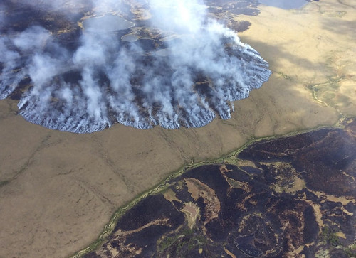
The Bogus Creek Fire burns in the Yukon Delta National Wildlife Refuge in southwest Alaska, June 7, 2015. Photo credit: Matt Snyder-Alaska Division of Forestry
You don’t have to be a rocket scientist to know that wildfires are more common during hot, dry summers. The area burned in the United States in 2015, over 10 million acres, according to the National Interagency Fire Center, occurred during a record temperature year for the Earth, plus record low snowpack and rainfall in some areas of the West.

The sizzling weather of 2015 was similar to what global climate models project for the year 2060. Last year’s weather and fire may become the new normal later in the 21st century.

A warmer climate is expected to increase the frequency and severity of fires. Historically, fires most often occur in the western U.S., as well as the boreal forest and tundra of Alaska. Current models predict that two to three times more area will burn annually in the West by 2050. This is a significant change in how wildfire will affect ecological systems and human communities in the future.

A longer fire season and bigger fires in Alaska would have a significant effect on the global carbon cycle. Organic soils in boreal forests and tundra contain up to 30 percent of the Earth’s terrestrial carbon, which can be released to the atmosphere by intense wildfires that burn deep into the soil. Temperature is increasing fastest at northern latitudes, thus increasing opportunities for wildfire to occur.

Foresters manage fuels to reduce fire intensity, vegetation mortality and damage to structures. In the Southeastern U.S., most pine forests are treated with prescribed fire every few years, keeping surface fuels and tree densities low to reduce the risk of fire. Forest thinning, prescribed fire and other means of fuel removal reduce fire intensity in dry forests in the western U.S.

Increasing temperatures coupled with increased wildfire will create new ecological and social challenges for federal resource managers. Warmer temperatures increase the complexity of conservation in terrestrial and aquatic ecosystems, threaten homes in the wildland-urban interface, and make the task of fire suppression even more costly.

By identifying “hot spots” where future wildfire may be especially pervasive and damaging to resources, the U.S. Forest Service and other federal agencies are developing adaptation options and locations where fuel treatments can be prioritized. They are also working with local communities to ensure that residents are prepared to live in areas where fire hazard is high.

Tweet
Posted by Bob Blogger at 5/31/2016 08:47:00 AM 2 comments:
Email ThisBlogThis!Share to XShare to FacebookShare to Pinterest

Saturday, May 28, 2016

CA-MMU O’Neals vegetation fire, One home lost

One home lost in contained O’Neals vegetation fire

O’Neals vegetation fire

By Mark Evan Smith

A 10-15 acre fire on Road 211 near North Fork Road (Road 200) that possibly destroyed the home of an area schoolteacher was contained this afternoon, Cal Fire staff said.

What started as a 5-acre vegetation fire about 2 miles from Spring Valley Elementary School, first reported by Vanessa Sammons at about 2:50 p.m. in the 24000 block of Road 211 in O’Neals, quickly grew as engine crews, water tenders, and air attack moved in to fight the flames.

Sammons was not the owner of the house - she keeps cows on the land and was en route to check on them when she saw the smoke.

“I immediately turned around and dialed 911,” Sammons said. “We’ll see if the cows are okay.”

No injuries were reported.

A neighbor who rushed over to assist in the fire - and didn’t want to be named - said a teacher, possibly from Spring Valley, lived in the home.

Outbuildings and property such as bicycles, vehicles, and gardening equipment were consumed by the flames.

Cal Fire engines and water tender crews, with support from the air, worked to prevent the flames from jumping across Road 211. The fire was contained at about 4:15 p.m, with hours of scheduled mop-up operations.

Air attack crews over the area reported the fire to be about five acres around 3:15 p.m., but the blaze quickly gained strength before it was stopped.

The cause of the fire is under investigation.

Source: http://www.sierrastar.com/2016/05/27/79092/vegetation-fire-burns-home-in.html
Tweet
Posted by Bob Blogger at 5/28/2016 01:29:00 AM No comments:
Email ThisBlogThis!Share to XShare to FacebookShare to Pinterest
California, USA O'Neals, CA 93645, USA

Wednesday, May 25, 2016

Shell Oil Spill Ten's of Thousands of Gallons of Oil Again, This Time in California’s Central Valley Tracy Altamont Pass Wind Farm

Shell Spills Again: Pipeline Leaks 20,000 Gallons of Oil in Northern California

by Ryan SchleeterFor the second time in two weeks, Shell has spilled thousands of gallons of oil, this time in California’s Central Valley.
Shell Pipeline Oil Spill in California
In the foreground, hazardous materials responders work to clean up oil from Shell's spill near Tracy, California. In the background, containers of the oil-contaminated soil sit among wind turbines
Less than two weeks after dumping nearly 90,000 gallons of oil into the Gulf of Mexico, Shell Oil is at it again. The company’s San Pablo Bay Pipeline, which transports crude oil from California’s Central Valley to the San Francisco Bay Area, leaked an estimated 21,000 gallons into the soil near in San Joaquin County this week.

Responders are on the scene to clear oil that’s reached the surface, which county officials say covered roughly 10,000 square feet of land. As of today, Shell representatives claim the pipeline has been repaired but have not resumed operations.

Local government officials and Shell responders are investigating the cause of the leak, and currently report that no oil has entered drinking water sources or populated areas.

While two large oil spills in two weeks may seem like a pretty epic failure — particularly for a company that just said “no release [of oil] is acceptable“ — in reality, this is what business as usual looks like for an industry built on polluting our environment and driving climate disaster.

In fact, this same pipeline sprung a leak just eight months ago in almost the same location, spilling roughly the same amount of oil into the ground.

Adding irony to injury, the spill occurred on the site of one the state’s largest wind energy developments, the Altamont Pass Wind Farm. Wind energy, it should be clarified, does not release toxic chemicals into the soil or contribute to runaway climate change. Perhaps Shell responders on the scene will take note.


Containers of oil-contaminated soil sit among wind turbines at the Altamont Pass Wind Farm near the site of the spill.

Interestingly, Shell officials decided to wait three days before releasing a statement to the public about the spill — after shareholders convened at the company’s Annual General Meeting in The Hague, Netherlands. The spill was first detected early Friday morning, but not publicly reported until Monday evening Pacific time.

Environmental watchdog groups are still monitoring the impacts of Shell’s spill in the Gulf, some pointing to the oil industry’s history of under-reporting the extent and impact of spills as a reason to stay vigilant.

What’s increasingly clear is that companies like Shell aren’t going to stop polluting in pursuit of fossil fuels we can’t afford to burn on their own — we’re going to have to rise up to stop them.

History shows us that the more fossil fuel infrastructure we have (and we have a lot in this country) the more spills like this we’ll see. So let’s not build more — business as usual for the fossil fuel industry cannot continue.

Help put an end to leaks, spills, and fossil fuel pollution while fighting for the climate at the same time. Tell President Obama to end all new offshore drilling today!

Source: http://www.greenpeace.org/usa/shell-spills-pipeline-leaks-20000-gallons-oil-northern-california/?
Tweet
Posted by Bob Blogger at 5/25/2016 08:04:00 PM No comments:
Email ThisBlogThis!Share to XShare to FacebookShare to Pinterest
California, USA Altamont Pass Wind Farm Substation, Tracy, CA 95391, USA

NIFC Mobilizes U.S. Wildland Firefighter Crews to Assist with Canadian Wildfires

Is that  copy of "Leading in the Wildland Fire Service" in a back pocket?

NIFC Mobilizes Wildland Firefighters to Assist with Canada Wildfires

The National Interagency Fire Center (NIFC) mobilized over 200 wildland firefighters to assist with the Fort McMurray fire in Canada this morning . Five of the crews flew on a Canadian aircraft out of NIFC in Boise, Idaho, at 9:15 a.m. and another five crews flew out of Missoula, Montana this morning. 

The crews are comprised of Bureau of Land Management, U.S. Forest Service and U.S. Fish and Wildlife Service wildland firefighters.
“We have a bilateral firefighting assistance agreement with the Canadian Interagency Forest Fire Centre, which works well when either country is in need of wildland fire suppression resources. Canada has assisted the U.S. many times in the past, so as soon as Canada requested assistance, we quickly accommodated their request,” says Dan Buckley, NIFC’s National Multi-Agency Coordinating Group Chair.
U.S. Wildland Firefighters Mobilized To Fight Canada Wildfires

On May 10, the U.S. mobilized two heavy air tankers and a lead plane to assist with wildfires in Canada. The tankers, based out of Bemidji, Minnesota, flew retardant to wildfires in the Ontario province for one day. In the last 5 years, the U.S. has supported Canada twice. In 2015, NIFC mobilized 200 firefighters and one heavy air tanker and in 2010, 30 smokejumpers and one Type 2 Initial attack crew were sent to Quebec.

Conversely, Canada has provided support for wildfires in the U.S. Over the last five years, the Canadian Interagency Forest Fire Centre (CIFFC) mobilized fire managers, large air tankers, water scoopers, smokejumpers and wildland fire crews, with the exception of 2010, as the U.S. did not request assistance that year.

For information about wildfires burning in Canada, visit the CIFFC website:www.ciffc.ca
Photo Credits: David Walsh, NIFC External Affairs

Tweet
Posted by Bob Blogger at 5/25/2016 07:51:00 PM No comments:
Email ThisBlogThis!Share to XShare to FacebookShare to Pinterest
California, USA Canada

CA-YNP Yosemite National Park Soup Bowl Prescribed Fire [MAP]

CA-YNP SOUPBOWL UNITS 2 & 3 - YOSEMITE NATIONAL PARK - PRESCRIBED FIRE

Soup bowl Prescribed FireMay 31, 2016

Yosemite National Park 2016 Planned Prescribed Fire May 31, 2016
Yosemite National Park fire managers are planning the 175 acre Soupbowl Prescribed Fire, Units 2 and 3, on May 31, 2016. Fire managers will wait for favorable weather conditions to begin the prescribe fire. Ignition will take 2 to 3 days and an additional 1 week of active burn down.
The primary objective is to reduce hazardous fuels within the mixed conifer forest adjacent to the Wildland Urban Interface (WUI) community of Wawona, park infrastructures at the south entrance station and the Mariposa Grove of Sequoias.  This project creates a continuous area of reduced fuel by linking together multiple previous fires and treatments, and mechanical thinning along the Wawona Road.
A secondary objective is ecosystem restoration.  Applying fire under prescribed conditions mimics the frequent, low-intensity lightning caused fires that occurred in Sierras prior to the exclusion of fire which began over 100 years ago under aggressive fire suppression policies. Historically, natural fires burned an average of 16,000 acres annually in Yosemite and played an integral role in shaping Yosemite’s ecosystems.  In the absence of frequent fire, unnatural levels of forest biomass have accumulated which has put many of Yosemite’s values at risk, including neighboring communities, and natural and cultural features.  As climate changes, these values become increasingly vulnerable to catastrophic wildfire.
Park employees, community members, and visitors can expect to see crews from various federal and state agencies conducting burn operations during the Soupbowl Prescribed Fire.  

Smoke will be present during the prescribed fire, particularly during late evening and early morning hours.  Fire managers are working with the Mariposa County Air Pollution Control District (MCAPCD) to time the project to coincide with favorable weather that will facilitate good air quality, and disperse smoke into the atmosphere away from the community.  Prior to ignition, a burn permit is issued to the park by MCAPCD and smoke monitoring equipment was installed in the community.  Community members who are sensitive to smoke may want to close their windows and doors and/or consider leaving the area during active ignition of the project in order to reduce their exposure.
  
For additional Information
Fire Information: gary_wuchner@nps.gov; 209.372-0459; and nancy_phillipe@nps.gov, 209.379.1188.
  • Yosemite National Park Web page: http://www.nps.gov/yose/blogs/fireinfo.htm
  • For Yosemite air quality: www.nps.gov/yose/naturescience/aqmonitoring.htm
  • Facebook: http://www.facebook.com/pages/Yosemite-Wildland-Fire/124632964255395
  • Twitter: http://twitter.com/#!/YosemiteFire
Tweet
Posted by Bob Blogger at 5/25/2016 03:51:00 PM No comments:
Email ThisBlogThis!Share to XShare to FacebookShare to Pinterest
California, USA Yosemite National Park, California, USA

Coffee Break Training: Getting the Most From the U.S. Fire Administration Daily National Operations Brief

Coffee Break Training: Getting the Most From the USFA's Daily National Operations Brief

Learning Objective: The student will be able to get daily in-depth information and/or updates on national incidents/events and weather. (PDF 127 KB)

Graphic NOAA / NWS
This graphic is generated by the National Oceanic and Atmospheric Administration through the National Weather Service at the following hyperlink: http://www.nws.noaa.gov/largemap.php.
 The U.S. Fire Administration’s Daily National Operations Brief provides a snapshot of the day’s incidents/events and weather that is occurring nationally. It provides an opportunity to know what is going on with a quick glance. Readers can expand their knowledge by using the hyperlinks imbedded throughout the brief’s two pages. The hyperlinks provide more details about important aspects of the day’s weather, news and health. 

USFA Daily National Operations Brief Sample First Page
 U.S. Fire Administration’s Daily National Operations Brief
Sample First Page

 These hyperlinks can be used throughout the day to see items as they are updated, even into the next news cycle. Weather hyperlinks are provided for fire, space, tropical activity, daily outlook and current watches/ warnings, which are shown along with a hyperlink. When appropriate, they are provided for rainfall/flood stages, tornado chances, snowfall accumulations and satellite imaging. 

This interactive graphic depicts national weather hazards for the continental U.S., Alaska and Hawaii; there are also links to weather hazards for American Samoa, Guam and Puerto Rico/Virgin Islands. The legend identifies the warning associated with each color on the map; clicking on the warning provides information on all the affected areas. If your concern is specific, just click on that area within the map graphic, and the specific warning(s) for that location will be provided. 

Health information hyperlinks include seasonal influenza; the latest health alerts from the University of Minnesota’s Center for Infectious Disease Research and Policy (News & Perspective section); and the World Health Organization (global alert and response disease outbreak news). When information is needed on a new health concern/outbreak, sources are located, and hyperlinks are provided (i.e., bird flu; Zika virus; Ebola virus). Also, two hyperlinks are provided concerning recalls, one from the U.S. Department of Agriculture and the other from the U.S. Food and Drug Administration. These hyperlinks include listings of latest recalls, market withdrawals and safety alerts. 

When you need to know more or have extra time, click on the hyperlink! If you do not already receive this brief and you wish to subscribe or download, please go to http://usfa.fema.gov/operations.

U.S. Fire Administration Daily National Operations Brief https://www.usfa.fema.gov/downloads/pdf/daily_ops_briefing.pdf
For archived downloads, go to:
05/25/2016 08:00 AM EDT
http://www.usfa.fema.gov/training/coffee_break/
Tweet
Posted by Bob Blogger at 5/25/2016 11:54:00 AM No comments:
Email ThisBlogThis!Share to XShare to FacebookShare to Pinterest
California, USA Administration, 5990 S Sterling Mall, Mesa, AZ 85212, USA

Tuesday, May 24, 2016

CA-BEU Metz Fire - Monterey County Wildfire

Metz Fire - Monterey County wildfire - CAL FIRE San Benito-Monterey Unit

 CAL FIRE spokesman Daniel Berlant said that the growth slowed after sundown Sunday.
The blaze broke out at about 3:30 p.m. Sunday and had burned just 800 acres in its first two hours but then surged to nearly 3,876 acres amid strong winds, as of 8 a.m. Monday.
The fire is burning near Soledad in Monterey County between the Salinas River and Pinnacles National Park.
Monterey County wildfire (May 22, 2016)
Credit: KSBW

Location: Metz Rd & Blue Jay Ln, southeast of Soledad, Monterey County.
Date/Time Started: May 22, 2016 3:27 pm
Updates: 

5-23-16 1900: 3,876 acres - 70% contained

Estimated - Containment: May 25, 2016
Total Fire Personnel: 102
Total Fire Engines: 10
Total Fire crews: 4
Total Water Tenders: 1
Conditions: A passing disturbance will maintain a cool and unstable air-mass over the region. Below average temperatures will assist in containment efforts. Isolated showers and thunderstorms are possible in the afternoon and evening.
5-22-16 0900:  3,876 acres; 50% contained Fire did not spread overnight.

Tweet
Posted by Bob Blogger at 5/24/2016 10:41:00 AM No comments:
Email ThisBlogThis!Share to XShare to FacebookShare to Pinterest

Monday, May 23, 2016

CA-LFD #LakeViewTerraceFire - Los Angeles Brush Fire CA-ANF-Wheatland

#LakeViewTerraceFire / #WheatlandFire Los Angeles Brush Fire
CA-ANF/LFD-Wheatland - Wheatland IC is in Unified Command between LAFD and ANF.


Location: 11326 Wheatland Ave; Sylmar 
Resource Notes: LAC Copter 15 and ST1104A have been released. H-554 committed from the BLM reporting to Fox first thing in the am. ST 9330c to form up for Wheatland incident.

Update 7:20PM; #LakeViewTerraceFire / #WheatlandFire is now at 184 acres, the fire is beginning to lay down and is 35% contained. Foothill Blvd is closed between Christy Ave to the west and Esko Ave to the east. Firefighters will continue to patrol neighborhoods north of Foothill Blvd ensuring safety and no flareups; FS 24; Batt 12; Valley Bureau; Council District 7; Erik Scott
Update; 5:16PM; 11326 Wheatland Ave; #LakeViewTerraceFire; Now 200+ acres. 
Update 4:13PM; 11326 Wheatland Ave; LAFD ‏ #LakeViewTerraceFire; Approx 120 acres. 
Update 3:06PM; 11326 Wheatland Ave; #LakeViewTerrace; Approx 8 acre fire running 
Update 2:20PM; 11326 Wheatland Ave; https://goo.gl/maps/Eao5r1VorPM2 …; 5+ acres
See more at: http://www.lafd.org/alert/update-brush-fire-05232016-3
Tweet
Posted by Bob Blogger at 5/23/2016 08:56:00 PM No comments:
Email ThisBlogThis!Share to XShare to FacebookShare to Pinterest
California, USA 11326 Wheatland Ave, Sylmar, CA 91342, USA

Saturday, May 21, 2016

CA-SHF Meadow Fire - McCloud Ranger District Shasta Trinity National Forest

Meadow Fire - CA-SHF Meadow Fire: 

Location: Fire is located 3 miles of east Coffee Creek. five miles east of McCloud Reservoir in the McCloud Ranger District.

Updates:
05/21/2016 1545: 20 acres burning in brush and timber, fire has slow rate of spread. 0% contained. 

****REMINDER**** Every fire has the ability to be catastrophic. The wildland fire management environment has profoundly changed. Growing numbers of communities, across the nation are experiencing longer fire seasons; more frequent, bigger, and more severe, fires are a real threat. Be careful with all campfires and equipment.

Tweet
Posted by Bob Blogger at 5/21/2016 09:58:00 PM No comments:
Email ThisBlogThis!Share to XShare to FacebookShare to Pinterest

San Bernardino City and San Bernardino County Fire Departments to Conduct Little Mountain Controlled Burn

San Bernardino City and San Bernardino County Fire Departments to Conduct Controlled Burn on Little Mountain Monday May 23rd


Date: 05/23/16
Location: Little Mountain Dr. just South of Kendall


The San Bernardino City and County Fire Departments will be conducting an organized live “Controlled Burn” on Little Mountain Dr., South of Kendall Dr., behind Shandin Hills Middle School on Monday May 23rd, 2016. 

All burning should occur between the hours of 8:00 a.m. and 2:00 p.m. The purpose of this burn is to provide both a buffer zone for future fire control while providing valuable training in wildland firefighting techniques.

“Controlled Burns” have proven to be very successful in protecting homes and property in Wildland/Urban Interface areas, in the event of an uncontrolled fire. These burns will only be conducted if favorable weather conditions are present on the day of the burn.

Firefighters urge residents to:

· Keep all doors and windows closed to minimize any inconvenience due to possible smoke.
· Stay out of the area and slow down if traveling on Little Mountain Dr. as fire department personnel will be actively working in the area.
· We anticipate no impact to Shandin Hills Middle School in regards to smoke.

The safety of citizens and property will continue to be our #1 priority before, during, and after the drill.

Contacts: Battalion Chief Bob Evans , PIO Mike Arvizo, PIO Jason Serrano
Contact Number: (909) 384-5401, (909) 384-5286, (909)289-6679-PIO Arvizo

Tweet
Posted by Bob Blogger at 5/21/2016 12:06:00 PM No comments:
Email ThisBlogThis!Share to XShare to FacebookShare to Pinterest
California, USA San Bernardino, CA, USA

Friday, May 20, 2016

CA-SLU Camp Roberts Fire, Camp Roberts Military Base, San Luis Obispo County [MAP]

Camp Roberts Fire, vegetation, San Luis Obispo County
CA-SLU Camp Roberts Fire
Location: Camp Roberts Military Base, 10 miles NW of Paso Robles
FRA / DOD
Start Time: 14:27

Updates:
05/18/2016 1900: 600 acres, Grass and oak woodlands, 0% contained

· Moderate rate of spread
· 90 degrees, 13% RH, wind SSW @ 18
· NO current structure threat
· CAL FIRE air and ground resources assigned
· USFS air resources assigned

Tweet
Posted by Bob Blogger at 5/20/2016 02:33:00 PM No comments:
Email ThisBlogThis!Share to XShare to FacebookShare to Pinterest
California, USA Paso Robles, CA 93446, USA

CA-SHF Mill Fire - Shasta-Trinity National Forest. 100% contained. [MAP]

Mill Wildland Fire - Shasta-Trinity National Forest.

CA-SHF Mill Fire
Map Credit: CFN 2016
Location: Fire is located 2 miles east of Weed, Ca. Shasta-Trinity National Forest.
Fuels: Burning in brush and timber

Updates:
05/21/2016 1543: 56 acres, 100% contained.
05/21/2016 0600: 56 acres, 75% contained. Full containment is expected today.
A small amount of snow fell over the fire area this morning. Weather in the area is forecasted to be much cooler and wetter through early next week.
No injuries have been reported, no evacuations have been ordered, and the cause of the fire is under investigation. Resources who responded to the fire include local volunteer fire departments, CAL FIRE, and US Forest Service firefighters from the Shasta-Trinity and Klamath National Forests. Two tankers and one helicopter were also used during initial attack.
05/20/2016 1140: 56 acres, 75% contained.
05/20/2016 0800: 56 acres, 50% contained. Fire has transitioned from Siskiyou Unit to Shasta-Trinity National Forest.
05/19/2016 2039: 56 acres, 5% contained with short range spotting.
05/19/2016 1839: 50 acres burning in brush and timber, 0% contained. Gusty northeast winds in the area.
05/19/2016 1701: 10 acres burning brush, 0% contained with short range spotting. Fire is located 2 miles east of Weed.

Tweet
Posted by Bob Blogger at 5/20/2016 02:18:00 PM No comments:
Email ThisBlogThis!Share to XShare to FacebookShare to Pinterest

Barstow Fire Protection District Wants To Be Annexed Into San Bernardino County District


Firefighters Want to be Annexed into CA County District

MIKE LAMB ON MAY 19, 2016
May 18--BARSTOW -- The president of the Barstow Professional Firefighters Association urged the City Council on Monday to consider annexing the Barstow Fire Protection District into the San Bernardino County district.

"I want to make the suggestion that we go forward with the proposal and look into that wholeheartedly," Barstow Fire Protection District Firefighter John Wymore said. He told the Council that the district is losing too many experienced firefighters to retirement and other departments.

Wymore attended a Barstow Fire District budget workshop earlier in the evening which offered an optimistic outlook that the district could stabilize despite the struggle to successfully transition pension plans from the San Bernardino County Employees' Retirement Association to the California Public Employees Retirement System.

One of the options on the table if the district fails to stabilize is being annexed into the county district.

"This fiscal year we are projecting revenues to be $4.7 million," Assistant City Manager Cindy Prothro reported during the workshop. "Expenditures are tracking at $5.1 million and we project a shortfall of just over a third of a million (dollars), which is a little higher than what we projected earlier this year."

But Prothro said the one factor that has been difficult to track is retirements.

"Otherwise we would have been tracking on or just under budget for the shortfall," she said.

Prothro is expecting the district to end the 2015-16 fiscal year at a negative fund balance of $1.2 million. But she said the district may see stabilization in 2016-17.

"We are expecting a loss of $135,000, which includes lease payments for a fire engine of $95,000," she said. "While we have another fire engine that needs to be replaced, our recommendation is not going after another engine (until) after the engine is paid off. We want to wait a year or two before we entertain acquiring another vehicle so we can help stabilize the district."

Mayor Pro Tem Tim Silva expressed concerns about maintaining proper staff levels.

"What it boils down to is what is our comfortable staffing levels," Barstow Fire Protection Chief Richard Ross. "Right now we consider that to be six (firefighters) per day is the bare minimum."

The department employs 18 firefighters besides Ross. But Wymore took issue with the staffing when speaking to the City Council.

"We (workshop) were talking about alternatives for the staffing. One of those that came up was reducing staffing at one of the fire stations in the district," Wymore said. "Currently, we run six firefighters a day and we are running more calls than ever. Last year we ran 5,500 calls -- a little bit more than 5,500. That's the most calls ever run in a single year.

"This year we are on track to probably do 6,000. Right at that range if we continue on the same track. So this really concerns me."

Wymore said the district has been losing firefighters to retirement and to other fire departments. He said some of those firefighters are longtime employees in Barstow.

"In the last year to 18 months we have lost four guys. One to retirement and three others to departments that are paying considerably better than us. Unfortunately, this retirement thing is really kicking our butts. We are paying the largest portion of retirement and I can tell you that is why we are losing guys. No other reason than that.

"The captain that retired, he retired directly because of that. And the other three firefighters left because of that."

He asked if the fire board would consider the district taking on 100 percent of the pension portion until a solution is found.

Fire District board Chairman Carmen Hernandez called for more research before any decisions are made.

"Because what unfortunately happened the first time we took over we didn't have what I believe was all the information we should have," she said. "We also have to have some input from the firefighters and their association. I think we need more updates more frequently so everybody has more understanding."

Mike Lamb can be reached at 760-957-0613 or mlamb@desertdispatch.com. You can also follow him on Twitter @mlambdispatch.

Copyright 2016 - Desert Dispatch, Barstow, Calif.

Tweet
Posted by Bob Blogger at 5/20/2016 10:59:00 AM No comments:
Email ThisBlogThis!Share to XShare to FacebookShare to Pinterest

One North County Fire Department Firefighter Injured After Engine Ran Off Road

CA Fire Engine Lands in Ditch After Crash

PAULINE REPARD ON MAY 20, 2016 

May 19--NORTH COUNTY -- A fire engine on its way to a brush fire collided with pickup and landed in a ditch off Old Highway 395 Thursday morning, the California Highway Patrol said.

One North County Fire Department firefighter was taken to a hospital with minor injuries while two others on the rig were not injured. Cal Fire Capt. Kendal Bortisser said. The 33-year-old pickup driver, from Escondido, was uninjured.

The collision occurred about 7:30 a.m. when the firefighters were heading south on the highway to check on a reported brush fire near Old Castle Road in Valley Center, CHP Officer Jim Bettencourt said. The fire engine's emergency lights and siren were on.

The driver of a northbound box truck towing a wood-chipping trailer yielded to the fire engine by pulling to the right side of the road. But the driver of a Toyota Tundra pickup behind the box truck was going too fast to avoid hitting the back of the truck's trailer, Bettencourt said.

The impact sent the pickup into the southbound lane, where it collided with the fire engine. The engine driver lost control of the rig and it swerved off the road, straight down into a ditch.

The collisions occured just south of Camino Del Rey, and north of Gopher Canyon Road, in the Bonsall area. Both directions of the highway were blocked for more than four hours as tow truck operators tried to get the heavy fire engine back on the road.

Other fire crews went to the Valley Center fire, which turned out to be someone burning vegetation illegally. It was extinguished and caused no damage, fire officials said.

Copyright 2016 - The San Diego Union-Tribune

Tweet
Posted by Bob Blogger at 5/20/2016 10:49:00 AM No comments:
Email ThisBlogThis!Share to XShare to FacebookShare to Pinterest
California, USA Valley Center, CA, USA

Tuesday, May 17, 2016

New Unit Chief Appointed for CAL FIRE San Mateo-Santa Cruz Unit

New Unit Chief Appointed for CAL FIRE

CAL FIRE NEWS RELEASE
Chief Ian Larkin
Felton – CAL FIRE Director Ken Pimlot has appointed Chief Ian Larkin as the CAL FIRE San Mateo-Santa Cruz Unit Chief. Chief Larkin replaces Chief Scotty Jalbert who recently transferred to the CAL FIRE San Luis Obispo Unit.

 Chief Larkin most recently served as the Unit’s Deputy Chief of Operations and has over 28 years of fire service experience in CAL FIRE operations, training, emergency command centers, administration and state incident command teams. 

 He now leads the Unit’s 260 paid staff across 17 fire stations and 110 volunteers across 8 additional fire stations that serve and protect the citizens of San Mateo and Santa Cruz Counties.

As the Unit Chief of the San Mateo-Santa Cruz Unit, Chief Larkin also serves as Fire Chief for CAL FIRE’s cooperative system with San Mateo County, Santa Cruz County, Pajaro Dunes and the Fire Protection Districts of Pajaro Valley and Coastside.

“Ian Larkin is a 5th generation Santa Cruz resident. We are lucky to have such a talented, community-invested individual to lead our County Fire Department”, said Nancy Gordon, Santa Cruz County Director of General Services.

CONTACT: Angela Bernheisel (831) 212-7805 RELEASE DATE: May 17, 2016
California Department of Forestry and Fire Protection
San Mateo-Santa Cruz Unit

Tweet
Posted by Bob Blogger at 5/17/2016 10:12:00 AM No comments:
Email ThisBlogThis!Share to XShare to FacebookShare to Pinterest
California, USA Cal Fire - Summit Station, 12900 Skyline Blvd, Los Gatos, CA 95033, USA

Thursday, May 5, 2016

CANADA: FORT MCMURRAY FIRE #YMMFIRE MAKES RUN ON FORT MCMURRAY AIRPORT FIRE AIR TANKER BASE / HELIPORT #YMM

Correction: MONTH OLD AMAZING IMAGES FROM THE ALBERTA CANADA FORT MCMURRAY #YMMFIRE

The huge wildland fire in Alberta Canada dubbed the #YMMfire on twitter made a run on the Fort McMurray Airport where It looked very dire for awhile and caused tanker operations to cease due to evacuation scramble. Taken off the tower NAV CANADA met cam.

Fort McMurray airport ‪#‎ymm‬ ‪#‎ymmfire‬

Fort McMurray airport ‪#‎ymm‬ ‪#‎ymmfire‬

Fort McMurray airport ‪#‎ymm‬ ‪#‎ymmfire‬

Fort McMurray airport ‪#‎ymm‬ ‪#‎ymmfire‬

Fort McMurray airport ‪#‎ymm‬ ‪#‎ymmfire‬

Fort McMurray airport ‪#‎ymm‬ ‪#‎ymmfire‬

Fort McMurray airport ‪#‎ymm‬ ‪#‎ymmfire‬

Fort McMurray airport ‪#‎ymm‬ ‪#‎ymmfire‬
Current Live Fort McMurray Cam: https://www.lookr.com/lookout/1349193322-Fort-McMurray#action-play-day

Picture Credit: All images from F.W. Harrison Facebook post.
Tweet
Posted by Bob Blogger at 5/05/2016 01:30:00 PM No comments:
Email ThisBlogThis!Share to XShare to FacebookShare to Pinterest
California, USA Fort McMurray (Forestry) Heliport, Fort McMurray, AB T9H 4B3, Canada

Sunday, May 1, 2016

CA-SCU/CZU: Open Burning Permits Now Required In CAL FIRE SRA

CAL FIRE transitioning to Requiring Burn Permits for Outdoor Burning

Burn Piles Require Burn Permit
May 1ST BURN PERMITS REQUIRED
Morgan Hill – Commencing May 1st, 2016 the California Department of Forestry and Fire Protection (CAL FIRE) will require a burn permit for any outdoor open burning in State Responsibility Areas (SRA) in the following CAL FIRE Units:

San Mateo - Santa Cruz
Santa Clara - serving Alameda, Contra Costa, Santa Clara and areas west of I-5 in Stanislaus and San Joaquin counties

State Responsibility Areas are generally the unincorporated, rural, grass, brush and timber covered lands. Open burning includes agricultural burns, hazard reduction burns but not campfires or BBQ’s.

Individuals who conduct open burning must keep the fire size within the issued permit requirements at all times. 

All open burning permits will require: 

  • Continual monitoring of the fire by an adult
  • A minimum clearance of at least 10 feet to bare mineral soil around the fire
  • Adequate onsite control resources (tools, water, etc.) 
  • No burning on windy days. 
  • Failure to maintain control of an open fire will result in the permit being voided and the permit holder could be cited and potentially held liable for paying fire suppression costs, civil damages and fines. 

Our debris burning safety video can be viewed at: https://www.youtube.com/v/_llJU5lJhmc

CAL FIRE burn permits are in addition to any required air quality control district and local fire agency permits. CAL FIRE Chiefs remind local residents “Open burning requires local landowners, to do due diligence to insure they are meeting all conditions set forth by authorizing agencies prior to conducting an open burn”.
For more information on burn permits or wildland fire safety, residents can contact their local CAL FIRE facility www.fire.ca.gov
CAL FIRE San Mateo - Santa Cruz Unit
Public Infomation Office 
Media Phone: (831) 335-6717
Twitter @CALFIRECZU

Tweet
Posted by Bob Blogger at 5/01/2016 04:29:00 PM No comments:
Email ThisBlogThis!Share to XShare to FacebookShare to Pinterest
California, USA CAL-FIRE Firefighter Matt Will Memorial Hwy, California, USA
Newer Posts Older Posts Home
Subscribe to: Posts (Atom)

Twitter Buttons

Follow @CalFireNews Tweet to @CalFireNews Tweet
****REMINDER**** Every fire has the ability to be catastrophic. The wildland fire management environment has profoundly changed. Growing numbers of communities, across the nation, are experiencing longer fire seasons; more frequent, bigger, and more severe, fires are a real threat. Be careful with all campfires and equipment.

"I am a firm believer in the people. If given the truth, they can be depended upon to meet any national crisis. The great point is to bring them the real facts, and beer." --Abraham Lincoln

View blog top tags
---------------------
CLICK HERE TO GO BACK TO TOP OF CALIFORNIA FIRE NEWS HOME PAGE

Subscribe via email to California Fire News - Keep track of Cal Fire News

Enter your email address:

Delivered by FeedBurner

Search This Blog

Current Fire Informational links

  • NICC - Federal Morning Report
  • CalFire - CDF - Active Incident information

CAL FIRE: Incidents

Loading...

Twitter links

Tweet - Follow @CalFireNews

Popular Posts

  • CA-STF-Rim Fire, Tuolumne County 187,466 acres, & is 23% contained, No expected containment date. Wilkins NC IMT1, Lawshe CA IMT1 #CaFire
    Rim Fire , CA-STF-2857  Wildfire  Tuolumne County  FRA 3 miles northeast of Groveland, near Clavey River Canyon ALL FURTHER UPDATES A...
  • (no title)
    Proposed fire district mergers in Calif. county face financial hurdles As smaller agencies seek to join with the Sonoma County Fire Distri...
  • CAL FIRE Announces Availability of Funding for Projects that Proactively Address Fire Prevention and Forest Health
     CAL FIRE NEWS RELEASE CONTACT: Scott McLean Deputy Chief of Communications (916) 651-FIRE (3473) @CALFIRE_PIO   ...
  • Arson suspect, Missouri man flies to California, sets 13 wildfires, then tries to fly home, cops say
    Freddie Graham, 68, arrested Monday A Missouri man flew to California, spent two days setting wildfires, then tried to fly home, offi...
  • Local News: City of Tracy Firefighters on the ZACA Fireline
    Tracy crews fight southland blaze Source: Tracy Press Bob Brownne Monday, 09 July 2007 Local ...
  • CAL FIRE / USFS Mariposa 2019 Fireline Safety Awareness For Hired Vendors
    2019 Fire line Safety Awareness For Hired Vendors 8hrs required annually for fire-line assignments with CAL FIRE and USFS We have the fo...
  • CA-YNP Yosemite National Park Remains Open - Yosemite Valley cannot be accessed from Merced via Highway 140.
    Yosemite National Park Remains Open Yosemite Valley accessible via Highways 140, 120, and 41 Yosemite National Park remains open wit...
  • CA-SNF-#CarstensFire #Wildland Fire CA-SNF-1261, Midpines, Mariposa County 1,708 acres 95% contained. #Cafire
    Carstens Wildland Fire  CA-SNF-1261 ,  Midpines , Mariposa County Evacuation orders lifted for: Jerseydale, Hites Cove, Clarks Valley and...
  • Chariot Fire 7055 acres, 100% [FINAL]
    Chariot Fire CA-MVU-014084 Incident is in Unified Command USFS-CNF and CALFIRE Evacuations: Multiple campgrounds on Mt Laguna including ...
  • #MountainFire #WildlandFire CA-BDF-10080 27,531 acres 100% contained. This will be the final report on this incident.
    CA-RRU-71832 -  CAL FIRE Riverside County Wildland Fire 27,531 acres 100% contained. This will be the final report on this incident. A T...

Blog Post Archive Index

  • December (1)
  • December (1)
  • November (2)
  • September (5)
  • August (4)
  • July (1)
  • May (2)
  • February (6)
  • December (9)
  • November (4)
  • October (2)
  • September (4)
  • August (4)
  • June (1)
  • May (2)
  • December (5)
  • November (4)
  • October (1)
  • July (5)
  • June (1)
  • May (2)
  • April (3)
  • February (4)
  • January (2)
  • December (4)
  • November (2)
  • October (6)
  • September (19)
  • August (1)
  • July (7)
  • June (39)
  • May (17)
  • April (23)
  • March (16)
  • October (15)
  • September (6)
  • August (69)
  • July (69)
  • June (65)
  • May (6)
  • April (8)
  • March (11)
  • February (19)
  • January (27)
  • December (5)
  • November (7)
  • October (10)
  • September (32)
  • July (10)
  • June (16)
  • May (50)
  • April (12)
  • March (32)
  • February (24)
  • January (46)
  • December (57)
  • November (50)
  • October (67)
  • September (57)
  • August (101)
  • July (135)
  • June (123)
  • May (155)
  • April (125)
  • March (86)
  • February (61)
  • January (63)
  • December (17)
  • November (83)
  • October (71)
  • September (49)
  • August (66)
  • July (117)
  • June (55)
  • May (29)
  • April (38)
  • March (86)
  • February (63)
  • January (31)
  • December (28)
  • November (37)
  • October (31)
  • September (38)
  • August (33)
  • July (31)
  • June (47)
  • May (36)
  • April (50)
  • March (17)
  • February (18)
  • January (29)
  • December (63)
  • November (74)
  • October (39)
  • September (51)
  • August (47)
  • July (56)
  • June (9)
  • May (6)
  • April (31)
  • March (113)
  • February (88)
  • January (64)
  • December (40)
  • November (16)
  • October (31)
  • September (42)
  • August (65)
  • July (176)
  • June (136)
  • May (125)
  • April (109)
  • March (154)
  • February (136)
  • January (132)
  • December (78)
  • November (149)
  • October (168)
  • September (75)
  • August (99)
  • July (72)
  • June (136)
  • May (124)
  • April (137)
  • March (86)
  • February (77)
  • January (104)
  • December (113)
  • November (93)
  • October (221)
  • September (96)
  • August (265)
  • July (332)
  • June (210)
  • May (136)
  • April (16)
  • March (52)
  • February (12)
  • January (48)
  • December (1)
  • July (1)

InciWeb Incidents for California

Loading...

googlesyndication

Contact Form

Name

Email *

Message *

Followers

CAL FIRE NEWS RSS FEED

Posts
Atom
Posts
All Comments
Atom
All Comments

Facebook Badge

California fire news

Promote Your Page Too

RSS FEED - GET BREAKING CALIFORNIA FIRE NEWS

California Fire News

↑ Grab this Headline Animator

Participate and help others get the real scoop - News, Pictures, Video, Intel

CAL FIRE NEWS
WANTS YOUR
INFO, INTEL, PICTURES,
209 REPORTS, VIDEOS, STORIES,
STATION AND CREW LINKS

send to
CAL FIRE NEWS WEBMASTER
ROCDAD@GMAIL.COM

CFN RSS FEED


calfirenews@gmail.com

California Fire News Content

  • California Fire News Home
  • California News
  • California Wildland Fire Links
  • DONATIONS

CAL FIRE NEWS NEEDS YOU!

WE NEED YOUR INFO, INTEL, PICTURES, 209 REPORTS, GREEN SHEETS, VIDEOS, STORIES,STATION AND CREW LINKS.
send to: calfirenews@gmail.com
CAL FIRE NEWS WEBMASTER

California Fire Department Tweets

Tweets from @CalFireNews/public-safety-fire-20

How fires get their names

Every year in California thousands of wildfires start throughout the state. In most cases, the dispatch center sending the initial resources to a wildland fire will designate a name for the fire, but the first on scene engine or fire official can also name the incident. Fires are usually named for the area in which they start – a geographical location, local landmark, street, lake, mountain, peak, etc. Quickly naming the fire provides responding fire resources with an additional locater, and allows fire officials to track and prioritize incidents by name. For example during the Southern California Fire Siege of 2003, the largest wildland fire in California history, the Cedar Fire in San Diego County, was named after the Cedar Creek Falls area where it started. The destructive Old Fire, which burned during the same time period in San Bernardino County, was named after the road along which it started - Old Waterman Canyon Road.
CAL FIRE is the largest fire department in California and the second largest fire department in the United States. CDF - CAL FIRE Firefighters answer the call more than 300,000 times a year. CAL FIRE Firefighters make up the fire department for 30 of our 58 counties in California and more than 100 local communities. We serve as the incident command during many of California’s most serious disasters. CAL FIRE Firefighters respond to many various types and forms of calls ranging from structural fires, to auto accidents, to earthquakes, to floods, to the spilling of hazardous materials, to every conceivable disaster; CAL FIRE answer's the calls. CAL FIRE is the largest fire department in California and the second largest fire department in the United States . CAL FIRE firefighters protect 33 million acres of State Responsibility Area (SRA). We have over 4,000 members within CAL FIRE and CAL FIRE is associated with the California Professional Firefighters (CPF) and the International Association of Firefighters (IAFF).

Go Back To Top

California Fire News - Focus on Wildland Fires throughout the state. Real fire news when you need it. CAL FIRE news, Fire & EMS Department News, ...
Cal Fire News is for casual public interest, and does *not*constitute an official warning system. Those who choose to read or receive Cal Fire News messages do so with the understanding they are *not* an official instruction, suggestion or permission to take action.


CLICK HERE - BACK TO TOP OF CAL FIRE NEWS HOME PAGE

Heroes

"We find not much in ourselves to admire, we are always privately wanting to be like somebody else. If everybody was satisfied with himself there would be no heroes." -- Mark Twain, Autobiography
CFN - California Fire News 2013. Simple theme. Powered by Blogger.