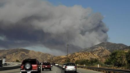
BAR FIRE - 110-acre fire that started today in the Plumas National Forest has closed Highway 70
Location: Feather River Canyon near Rich Bar, about four miles east of Belden., north of highway 70, GPS: 40 00.07 X 121 09.98
Terrain/Fuels: Heavy timber in steep terrain.
Fire behavior: Rapid ROS, Fire heading towards Red Hill(communications)
IA: 60-70 acres, A-512, T-93, T-23, C-512 enroute, From tanker in air, smoke showing good from valley.
WX: Temp 90, RH 12%, Winds S @4 gusting to 19
Updates:
1900- 110ac per Inciweb 1hr ago: http://inciweb.org/incident/2053/
1700- Jumper 51 dropped 10 jumpers who were on their way home from a prepostion in Fresno.
1645- AA06 estimating 120 acres,
1530- T-23, T-88, T-89, T-93, AA06, copter 510, 512, 68AH and Jump 51. Using Chester air base.
1510- Antelope Crews 1 thru 5 just dispatched to this incident
1500- 100 ac per AA
Road Closure: Highway 70 is closed in both directions from one mile west of the Jarbo Gap in Butte County to the highway's junction with Highway 89 at the Greenville Wye in Plumas County, California Department of Transportation spokesman Michael Mayor said this evening, The highway may be closed until noon Sunday, Mayor said.
Resource orders:Air resources: AA 06, T-93, T-88, T-89, H-512, H-510, H-514, H-522, 58AH. Air attack put in an order for 2, type 1 copters but none were available. All tankers loading out of Chester.
Cause: Under investigation.
Related Story: Plumas forest fire closes Highway 70 - Link
Saturday, July 31, 2010
CA-LAC -Crown Fire 13,918 acres - 82% Full containment expected Monday
Crown IC - Los Angeles County - Wildland Fire Update
Name: Crown IC (Agua Dulce)County: Los Angeles County
Location: North of Sierra Highway at Anthony Road, southwest of Palmdale
Administrative Unit: LAC - Los Angeles County Fire)
Current Status: 82% Contained @ 13918 Acres
Personnel: 1320
Start Date: Thursday July 29th at 2:22 pm
Last Update: July 31st at 6:30 pm
Evacuations orders rescinded - The Los Angeles County Fire Department and the Los Angeles County Sheriff’s Department appreciate the cooperation of residents in complying with evacuation orders.
Road Closures/Access: Road now open from Elizabeth Lake Road to Godde Hill and Bouquet Canyon. Access will be limited to residents only. Access continues to be limited to residents only in the following area: Godde Hill Road from Elizabeth Lake Road to 60th Street West and Avenue N.
For the latest road closures please go to Public Works Web site.
View Crown IC (Agua Dulce) in a larger map
Additional Information:
Full containment is expected Monday, 8/2
VLAT: Both the Evergreen Super Tanker( Boeing 747) and Very Large Tanker 911(DC-10) were used concurently for suppression on this fire.
Last nights weather allowed fire crews on the ground to continue to strengthen control west flank lines of the fire. First responders will continue to be working in the affected areas and firefighters will continue to construct lines, work on any remaining hot spots and patrol the area.
More Info: LA County Fire - Link - CAL FIRE Incidents - Link
SJFD Firefighters make major pay and benefit concessions to Keep Stations Open
San Jose Firefighters to Make Major Announcement to Keep Stations Open
SAN JOSE, Calif., July 31
| WHAT: | San Jose Firefighters, Local 230 will announce pay and benefit concessions that will save the City of San Jose millions of dollars and keep firefighters protecting the residents and businesses of San Jose. | |
| WHO: | Randy Sekany, President, San Jose Firefighters, Local 230 Firefighters layed-off over the past three days | |
| WHEN: | August 1, 2010 11:00 AM | |
| WHERE: | San Jose Fire Department Training Center 255 South Montgomery Street San Jose, CA 95110 | |
The loss of 49 Firefighters and closure of 4 fire engines and one fire truck will increase emergency response times and put lives and property at greater risk. The firefighters' offer will allow the City to keep the 4 fire engines and fire truck in service.
Source: San Jose Firefighters, Local 230
West Fire caused by equipment use.
Kern County Arson Unit along with CAL FIRE Law Enforcement has determined that the cause of the West Fire was from equipment use.
Daniel Gentle 47, and Michael Kulikoff 23, were cleaning the property at 16650 Blackburn Canyon Road.
The two men who had permission to be on the property were cutting steel pipe with a mechanized saw causing sparks which ignited near by brush.
The two men have been cited for a misdemeanor under PRC 4435 for causing a fire using mechanized equipment.
CA-LAC- Glendora IC - Vehicle Accident with wildland fire extension
Glendora IC: (ANF -3232) 2nd alarm Brush Fire: Los Angeles County - Angeles National forest - FS86,
Location: Glendora Mt Rd x Big Dalton Cyn., Los Angeles, CA
ICP: currently on Glendora Mt.Rd.
Sizeup: Reported TC w/Fire, E86 1 mile out heavy smoke balance to brush. B6-T17
Location: Glendora Mt Rd x Big Dalton Cyn., Los Angeles, CA
ICP: currently on Glendora Mt.Rd.
Sizeup: Reported TC w/Fire, E86 1 mile out heavy smoke balance to brush. B6-T17
Resources: *Glendora IC* BC16 IC, E86 Ops
Resource List as of 1330hrs Incident 3232, the following ANF units are at scene - WT22 WT25 Pat21 Pat25 BC21 Crew3 Div2 E23 E25 E26 E27 - E14 is still responding.
ANF E14 is on scene, AZ E37 is also at scene (ANF has 10 engines from Arizona listed on the Resource list - several are on the Biggs incident)
BDF E-337,
Communications: A-Blue6, C-Blue7, PTac-T17, STac-State White 2, C/D-Blue14D, Air/Grn-T19
Copters on Victor 7 135.9750, Air-Ground 170.000
LACoFD Glendora IC Updates:
1525hrs- LACO engines being released . ANF and crews handling mopeup. E82, E152 & E103 to remain..
LACoFD Glendora IC Updates:
1525hrs- LACO engines being released . ANF and crews handling mopeup. E82, E152 & E103 to remain..
1445- 50% containment, crews will be working until 1800. DC6 passing command back to AC41.
2000- 15 acres with 80% containment. Releasing Air Support. AC41 requesting ambulance to respond and standby at the command post.
1230- ICP on Glendora Mt.Rd.
1226- LACoFD & ANF onscene- 7 to 10 acres in heavy fuel. 1144- No rescue in progress, found TC victim.
1217- FS86. E86 OS 1-2 acres in heavy fuel going up hill. E86 is Glendora IC req complan
CA-Crown Fire: YouTube Evergreen 747 Super Tanker T-979 on fire yesterday.
San Bernardino: New county iPhone app allows residents to combat blight
Residents armed with iPhones are now the County of San Bernardino’s newest weapon against
graffiti, illegal dumping, and blight.
The county’s Code Enforcement Division has unveiled its new “SBcode” iPhone application,
allowing residents with iPhones to point, click and send photos of graffiti, illegal dumping and other
code violations to San Bernardino County Code Enforcement officers.
Board of Supervisors Vice Chair and Fifth District Supervisor Josie Gonzales advocated strongly
for the use of this responsive technology to help thwart blight in the county’s unincorporated
communities.
“The SBcode app empowers iPhone users to be part of our countywide clean-up efforts,”
Gonzales said. “Residents providing us with this real-time information enable our Code Enforcement
officers to respond faster, speeding up our abatement activities and sending a clear message to
vandals that graffiti and illegal dumping activities will not be tolerated in our neighborhoods.”
“SBcode” is a free application developed by Graffiti Protective Coatings and can be downloaded
directly from the iPhone App Store by simply searching the keyword “SBcode”. Once installed, users
can open the application and follow the prompts to take a photo and submit the violation. Using the
iPhone’s built-in global positioning system (GPS), the application will attach a location to the picture
and send the complaint to a Code Enforcement Officer for investigation.
“The County is exceedingly proud of the forward thinking staff that continues to utilize the
expanding technology available in order to better respond to residents,” said Board of Supervisors
Chairman Gary Ovitt.
The “SBcode” application was developed at no cost to the county and will simplify the complaint
reporting process for many residents while increasing the efficiency in which violations are addressed.
A version of “SBcode” for Android users will soon debut, and the county is looking into developing
versions for other operating systems as well, such as BlackBerry.
Source: ggg - Link
TTags: #SBcode, #iPhone
California Wildland Fire Updates: 07/30/2010 #CaFire
California Wildland Fires today: Situation Report - Saturday, July 31, 2010 – 0530 MDT
National Fire Activity: National Preparedness Level 2
Initial attack activity: Light (152 new fires)
New large fires: 1 (*)
Large fires contained: 3
Uncontained large fires: ** 8
Area Command Teams committed: 0
NIMOs committed: 0
Type 1 IMTs committed: 2
Type 2 IMTs committed: 2
Nationally, there are 54 large fires being managed to achieve multiple objectives.
** Uncontained large fires include only fires being managed under a full suppression
strategy. **
Southern California GeographicArea
New fires: 18
New large fires: 0
Uncontained large fires: 3
Type 1 IMTs committed: 2
Crown IC: - Los Angeles County 62 % Contained 1398 Acres
Additional Information: Four residential homes destroyed.
Last nights weather allowed fire crews on the ground to continue to strengthen control west flank lines of the fire. Conditions continue to be very fluid and may change quickly based on weather factors. The threat to the power lines has decreased significantly.
Road closures and access: Access is also now open from Elizabeth Lake Road to Godde Hill and Bouquet Canyon. Access will be limited to residents only. Access continues to be limited to residents only in the following area: Godde Hill Road from Elizabeth Lake Road to 60th Street West and Avenue N.
West Fire - Kern County (CA-KRN-021461) 1,658 acres, 85% contained.
Location: 4 miles S/SE from theTehachapi community. Lat: 35° 3´ 29" Long: 118° 25´ 33"
Structures Destroyed: 41 OUTB , 23 PRIM
Overhead Team Name: Zombro(CAL FIRE)/Stevens(KRN)
Total Personnel: 1,051
Fire activity: Moderate with occasional torching.
Bull Fire - Sequoia NF (CA-SQF-2701) 16,460 acres, 65% percent contained.
Location: Kernville, Ca - Lat: 35° 52´ 28" Long: 118° 27´ 9"
Overhead Team Name: Rocky W. Opliger Organization: Type 1 Team
Fire activity: Creeping and smoldering. Numerous residences threatened.
Structures Threatened: 30 PRIM
Structures Destroyed: 8 PRIM , 6 OUTB
Briggs Fire (CA-ANF-3201) FINAL - 530 acres, 100% contained.
Location: ACTON, Ca Latitude: 34° 26´ 17" Longitude: 118° 17´ 2"Overhead Team Name: Loring Buchwald
Costs to Date: $530,000
Swartzlander's Team
National Fire Activity: National Preparedness Level 2
Initial attack activity: Light (152 new fires)
New large fires: 1 (*)
Large fires contained: 3
Uncontained large fires: ** 8
Area Command Teams committed: 0
NIMOs committed: 0
Type 1 IMTs committed: 2
Type 2 IMTs committed: 2
Nationally, there are 54 large fires being managed to achieve multiple objectives.
** Uncontained large fires include only fires being managed under a full suppression
strategy. **
Southern California Geographic
New fires: 18
New large fires: 0
Uncontained large fires: 3
Type 1 IMTs committed: 2
Crown IC: - Los Angeles County 62 % Contained 1398 Acres
Personnel: 1300 plus
Start Date: Thursday July 29th at 2:32 pm
Last Update: July 31st at 11:30am
Fire Fuels/activity: 20+ square miles, Chaparral. Active fire behavior. Numerous structures and major transmission lines threatened. Evacuations lifted. Additional Information: Four residential homes destroyed.
Last nights weather allowed fire crews on the ground to continue to strengthen control west flank lines of the fire. Conditions continue to be very fluid and may change quickly based on weather factors. The threat to the power lines has decreased significantly.
Road closures and access: Access is also now open from Elizabeth Lake Road to Godde Hill and Bouquet Canyon. Access will be limited to residents only. Access continues to be limited to residents only in the following area: Godde Hill Road from Elizabeth Lake Road to 60th Street West and Avenue N.
West Fire - Kern County (CA-KRN-021461) 1,658 acres, 85% contained.
Location: 4 miles S/SE from theTehachapi community. Lat: 35° 3´ 29" Long: 118° 25´ 33"
Structures Destroyed: 41 OUTB , 23 PRIM
Overhead Team Name: Zombro(CAL FIRE)/Stevens(KRN)
Total Personnel: 1,051
Fire activity: Moderate with occasional torching.
Significant Events: No significant fire growth. Completed re-entry of displaced residents.
Remarks: Potential for spotting via wind driven brands, dust devils, and torching continues. Diminished threat to the electrical infrastructure for the city of Tehachapi, wind generator farms, and to structures.
Observed Fire Behavior: Occasional torching through pinyon pine mortality areas (40%). Smoldering with pockets of activity in 1000 hour fuels.
Planned Actions: Continue with mop-up. Demobilize excess resources to support new fires and initial attack. Bull Fire - Sequoia NF (CA-SQF-2701) 16,460 acres, 65% percent contained.
Location: Kernville, Ca - Lat: 35° 52´ 28" Long: 118° 27´ 9"
Overhead Team Name: Rocky W. Opliger Organization: Type 1 Team
Fire activity: Creeping and smoldering. Numerous residences threatened.
Structures Threatened: 30 PRIM
Structures Destroyed: 8 PRIM , 6 OUTB
Significant Events:
Remarks: There are still forest and road closures in effect.
Observed Fire Behavior: creeping and smoldering
Planned Actions: no night shift
Location: ACTON, Ca Latitude: 34° 26´ 17" Longitude: 118° 17´ 2"Overhead Team Name: Loring Buchwald
Costs to Date: $530,000
Significant Events: Evacuations of campground in Soledad Canyon was lifted. Soledad Canyon Road is open. 100% containment as of 1800hrs. on 07/30/2010.
Observed Fire Behavior: Minimal
Planned Actions: Continue mop up and holding operations.
Northern California Geographic Area
McDonald Fire, CA-NOD, is 10,677 acres and 75 percent contained.Swartzlander's Team
Friday, July 30, 2010
Morning Report - California Wildland Fires Quick Look
California Wildland Fires Today
 |
| Satellite Hot Spot detection map |
California Fire Activity
Crown Fire (CA-LAC-169211) 8,000 acres, 5% contained.
Briggs Fire (CA-ANF-3201) 561 acres, 52% contained.
West Fire (CA-KRN-021461) 1,658 acres, 46% contained.
Bull Fire (CA-SQF-2701) 16,460 acres, 55% percent contained.
Constantia Incident, NV-CCD, is 100 percent contained at 1369 acres.
Russel Complex, CA-LMU, is 100 percent contained at 100 acres. Fire under local command.
Birthday Incident, CA-MDF, is 100 % contained at 147 acres.
Northern California Area (PL 3)
New fires: 19
New large fires: 0
Uncontained large fires: 1
Type 2 IMTs committed: 1
McDonald (W-23), Northern California District, BLM. IMT 2 (Swartzlander). Three miles northeast of Termo, CA. Juniper, brush and grass. Active fire behavior. Residences threatened.
Southern California Area (PL 2)
New fires: 10
New large fires: 2
Uncontained large fires: 4
Type 1 IMTs committed: 2
Crown, Los Angeles County FD. Seven miles northwest of Acton, CA. Chaparral. Numerous structures
threatened. Evacuations in effect. No further information received.
West, Kern County FD. Cal Fire IMT 1 (Zambro). Five miles south of Tehachapi, CA. Grass. Moderate fire activity
with occasional torching. Residences threatened. Evacuations in effect.
Bull, Sequoia NF. IMT 1 (Opliger). Eight miles north of Kernville, CA. Brush and grass. Creeping and smoldering. Numerous residences threatened.
National Fire Activity
Initial attack activity: Moderate (227 new fires)
New large fires: 3 (*)
Large fires contained: 7
Uncontained large fires: ** 11
Area Command Teams committed: 0
NIMOs committed: 0
Type 1 IMTs committed: 2
Type 2 IMTs committed: 2
Nationally, there are 54 large fires being managed to achieve multiple objectives.
** Uncontained large fires include only fires being managed under a full suppression
strategy. **-
CA-LAC- Crown IC 8000 acres, 5% Cont. - All evacuations are now lifted
 |
| CA-LAC- Crown Fire - Geo Mac Wildfire Hot Spot Map |
-- currently updating this post -
Updates: 7-30-10
0730hrs: AT9110 is currently dropping on the fire
0700hrs: Tanker 911(DC-10) on deck,
ICP: Acton County Park
Video Feeds: CBS 2/KCAL 9 live feed - Link
MyFox - link
Previous related post: CA-LAC- Crown IC (Agua Dulce) - 6000-7000 est acres, 0%, Structure loss
Thursday, July 29, 2010
CA-LAC- Crown IC (Agua Dulce) - 6000-7000 est acres, 0%, Structure loss
CA-LAC- Crown IC (Agua Dulce): Los Angeles County California Wildland fire (Brush)
Incident Radio Feed: LACOFD BLUE 4 - COMMAND Feed
More Info sources:
Los Angeles County Fire website- Link
Los Angeles County Fire Twitter - Link
WildlandFire.com - Link
#Wildland #Cafire #lacfd #CalFire #LAFire
 | |
| Seen from the 14 Freeway, a fast moving wildfire burns near Acton, Calif. on Thursday, July 29, 2010. Credit: Story link (AP Photo/Dan Steinberg) (AP Photo) |
| Los Angeles County Wildland Fire - Crown IC (Agua Dulce): Current Fire conditions: Fast Rate of spread, Multiple ground resources en-route and on scene. Air resources being diverted from a 30 acre Lancaster Fire Location: LA County off Hwy 14 and Crown Valley near Agua Dolce, Fire is burning north of Sierra Highway at Anthony Road. Evacuation Centers:
Update: From a county source, it was McDill that burned, not Hauser. Hauser Peak. (Radio system) Fire Damaged. Due to damage at Mount Hauser Radio reperter/microwave site FIRE and LEO radio repeaters are currently disabled, LACoFD utilizing the Whitaker Peak repeater site for Blue 4, 8, 11, 12.
GeoMac near real-time information, fire perimeter data is updated daily based upon input from incident intelligence sources, GPS data, and infrared (IR) imagery from fixed wing and satellite platforms.- Link Narrative updates:2400hrs: Everyone on the fire-lines stay safe tonight #LCES - 10 Standard Fire Orders - 18 Situations That Shout Watch Out! - Go Home in 1 piece.Several Strike Teams are at the Palmdale staging area. They will rest overnight & relieve the crews that are working now in the A.M. 2300hrs: 6000-7000 est acres, LACoFD & LAFD will continue Air Ops throughout the night as long as possible. Structure protection in place. 2230hrs: Fire has spotted over the California Aqueduct on the North side and now burning into structures in Rancho Vista area. #WUF 2320hrs: Official PIO update - 3 small out buildings lost, 1 hay storage building now burning, 0 homes lost WX: Winds now averaging 20 kts, down from 25-35 at 2200 hrs. Predicted to be light at 0600. Temps dropping quickly, now 79, down from low 90's at 2200 hrs. Temps predicted to be 100 degrees tomorrow. 2130hrs: IC requesting AA up at 0600, 4 ATs up at 0700 and Tanker 910 over fire at 0700 2115hrs: Req Air Force Plant 42 WT to man and set up Helispot 24 Delta for the remainder of the night. per LACFD Twitter - link 2100hrs: Structures lost on Mt Hauser and LACSD and Fire radio repeaters down in the north county due to damage, CBS Copter2 showing one of the buildings on the repeater site burning. 2030hrs: Estimating fire is at 5500+ acres now 0% containment. 2000+ homes under mandatory evacuation orders, Fire has reached homes on Boquet Canyon Road - Fire will back down toward Godde Hill Rd tonight, Request for 12 additional WTs will be filled by 0900, Repeater sites on Mt McDill directly threatened. LA County IMT has been activated for this fire.KCAL TV-9 helicopter video showed fire encroaching in the doorway of the Hauser Peak county radio building at about 2030hrs. 2000hrs: IC requesting 4 ATs, 1 Lead and 1 AA for tomorrow morning, Orange County Copter 3 enroute. 1930hrs: Briggs Ops is releasing resources to the Crown IC Continuing Mandatory evacuations for parts of Leona Valley. 1900hrs: Type 1 ST to report to Elizabeth Lake Road and 20th Street West, IC requested 4 additional airtankers - Per South Ops, highly unlikely they will be able to fill 4 additional ATs in time to work tonight. 1845hrs: 1 structure now on fire and 15 others being evacuated on Elizabeth Lake Road 1830hrs: 2000 acres, at least 1 Structure lost, Fire is burning north of Sierra Highway at Anthony Road. IC just asked for 10 type 1 engine strike teams to report to Palmdale staging immediate need 1800hrs: *Crown IC* Fire at 800+ acres. Mandatory evacs for parts of Leona Valley. Calling for aerial drops due to structure threat, *Briggs IC* Releasing E 82's, E 149's, E132's, E 111's, E 76's & WT 73's to the Crown IC as per their need with Strike Team 1170C is to form up under the command of BN 5A and stage at Ave S @ 14 Fwy. 1740hrs: Crown IC has established 2 staging areas for the Crown Incident. First on the South end of the fire is at Highway 14 x Red Rover Road, and the second is in Leona Valley and known as Valley Staging and is located on Elizabeth Lake Road between Ridder Road and Godde Hill Road. 1730hrs: Per Crown IC, 500 acres, 0% containment 1645hrs: 200 acres, Crown IC asking for LAC 3rd alarm, Staging Anthony Road. Fire backing into Leona Valley.XRI ST TYPE 3 en route 14505hrs: 80-100 acres, IC requested a 2nd alarm, Total of 4 AT's on this fire now.There are at least two starts. One start was on Crown Valley Rd, the other on Anthony Rd. LA County Fire Camp 11 amongst several other structures are threatened and have been evacuated. 1430hrs: Multiple Structure threats, at least 5 acres in medium to heavy brush and grass. This is the 3rd fire in the area burning at the same time. 14:22hrs: Fire reported 3 to 5 acre sizeup. Resource Notes: Resource orders: 2145hrs: 4 Type I Strike Teams just launched from Orange County – 2 ORC and 2 XOR from Metronet. 2100hrs - Single Resource Engines Type 1 - 19 Filled, 16 unfilled Type 4 - 4 filled, 0 unfilled Engine Strike Teams Type 1 - 13 Filled, 0 unfilled Type 3 - 8 filled, 5 unfilled Type 4 - 0 filled, 2 unfilled 20:45 - Additional request for tomorrow morning 6 type 2 helicopter 2 type 1 copters 2 sky cranes XLC sent - 1204a - SGB E52 / MPK E61 / ALH E74 / MRV E101 / ARC E105 - BC105 leader also - 1203a - BRK E11 / BRK E15 / GLN E25 / GLN E26 / PAS E36 - BC3 Leader and - 1205a - BRK E12 / BRK E14 / GLN E29 / PAS E31 / SNM E91 - BC7 Leader Fire Map:View Crown IC (Agua Dulce) in a larger map | ||
updated as of 7:28pm 7-29-30 |

More Info sources:
Los Angeles County Fire website- Link
Los Angeles County Fire Twitter - Link
WildlandFire.com - Link
#Wildland #Cafire #lacfd #CalFire #LAFire
CA-ANF/LAC- Briggs IC (Soledad Canyon) - 530 acres, 100%
Briggs IC (Soledad Canyon) Wildland brush Fire Updates as of 7:28pm 7-29-30: Briggs IC* Per IC final acreage was 530. Activities throughout the night will be tying in containment lines.*Briggs IC* Reporting Knockdown @ 20:03 Hours. Extensive mop-up and cold trailing ahead w/ handcrews & Dozers. Fire was reported at 2:56 Location: South of the 14 Freeway, near Soledad Canyon Rd, burning towards Angeles National Forest. It is burning in a semi-rural area toward the old North Fire footprint from Sept. "06" and the Station Fire Aug. "09" Basic Information from Inciweb - Incident Link
| ||||||||||||||||||||||
----------- Briggs IC Comm Plan - A-Blue 11/C-NIFC TAC 1/Prim TAC 20/Sec TAC NIFC T2/ A-G USFS Region 5 |
Fire Chief blog: Featured article - Anti-Social Media
Anti-Social Media
I heard a frightening story this week. A firefighter did not report for his shift. His fellow firefighters stopped by his apartment, where they found his body. The co-workers called 911, bringing out paramedics and later the fire chief, all devastated by the loss.
Other firefighters who weren’t on scene learned of the death via text message. The texts and cell phone calls quickly spread and eventually, news of the firefighter’s death appeared on Facebook. While en route to notify the firefighter’s estranged wife, the fire chief started receiving instant messages and texts asking about the death.
“We were so afraid his wife would hear it from a text or phone call before we could tell her in person,” the chief told me.
Fortunately, the wife was late getting home and doesn’t answer her cell while driving, so the chief was able to break the news to her in person. He added that a couple hours later, the wife started to compose a list of people to notify —family, friends and military buddies.
“Of the 10 names on that list, five had called because they saw it on Facebook,” he said.
Last month, my family learned of the sudden death of a young friend of my daughters’ via Facebook. The news itself was shocking, but it became quickly obvious that the family and close friends were not prepared for the deluge of phone calls of concern.
While newspapers and television news will hold the name of victims pending notification of family members, smartphones put the grapevine or phone tree on steroids.
There are plusses and minuses with today’s instant news delivery. For instance, departments can mass-deliver tornado warnings or evacuation-route update via texts. But can you imagine what would happen if tragic or incorrect information was sent out?
I’m just finishing the book, The Facebook Effect by David Kirkpatrick, the story of the origins of Facebook and its role in changing how people communicate. Facebook founder Mark Zuckerberg’s idea not only connected college students and high-school students, it opened up the world. Adults have found a new way to connect with family, friends and reconnect with people from the past, witnessed by Facebook’s announcement that it had reached 500 million users.
A couple years ago, I cautioned about first responders taking photos and posting them on Web sites, but how do you set rules or etiquette for texting or posts on Facebook, Twitter or whatever comes next?
How do you manage this new breed of social media reporters?
Source Article @ Fire Chief Magazine Blog - Link
CA-BEU-Idria Fire: 20 acres, 100%
CAL FIRE crews are battling a 10 acre fire off New Idria Rd in the community of New Idria (San Benito County).
New Idria Fire now 100% contained at 20 acres. Abandoned ghost town. IC reports many out building and structures destroyed.
Related INFO LINKS:
Twitter Hash tag #CAFire
Official CAL FIRE Facebook link
CALIFORNIA FIRE NEWS: Twitter Link
Molloy orders review of U.S. Forest Service's use of aerial fire retardants
Siding with an environmental watchdog group, a Missoula judge this week ordered the U.S. Forest Service to take a hard look at its use of toxic aerial fire retardants and their impact on fish and wildlife habitats.
By TRISTAN SCOTT of the Missoulian Link
In a 79-page decision filed Tuesday, U.S. District Judge Donald Molloy ruled the Forest Service violated the federal National Environmental Policy Act when it determined the chemical slurry has only insignificant environmental effects.
The Forest Service Employees for Environmental Ethics, an Oregon-based nonprofit group, filed suit more than two years ago in U.S. District Court in Missoula. The lawsuit names the Forest Service, the U.S. Fish and Wildlife Service and the National Marine Fisheries Service, and accuses the three agencies of violating NEPA, the Endangered Species Act and other federal laws.
Molloy ordered the Forest Service to comply with the federal laws by Dec. 31, 2011, threatening contempt sanctions if the agency fails to do so.
"The Federal Defendants are advised that failure to comply with this deadline may subject them to sanctions, including contempt proceedings, and could conceivably result in enjoining the continued use of aerially-applied fire retardant until the law enacted by Congress is complied with," Molloy wrote. "The issue requires immediate attention."
Molloy did not prohibit the use of fire retardant before that deadline, and a Forest Service official said retardant airdrops would continue under guidelines currently in place to protect fish and wildlife habitat.
Retardant airdrops are prohibited within 300 feet of waterways unless people, property, infrastructure and critical natural resources are threatened.
Jennifer Jones, a spokeswoman for the Forest Service, said agency officials are currently reviewing the ruling, and will work with the Fish and Wildlife Service and the National Marine Fisheries Service to "comply fully" with Molloy's order.
"We strongly agree with the National Environmental Policy Act, and protecting fish and wildlife habitat remains one of our top priorities," Jones said. "Millions of acres of national forest are at risk of uncharacteristically large and severe wildfires that can cause long-term damage to fish and wildlife habitat as well as humans, and retardant is a useful tool in fire suppression both in the wildlands and near communities."
Jones said it was too early to say what the agency's next steps would be or whether it would appeal the decision.
Molloy also ruled the U.S. Fish and Wildlife Service and National Marine Fisheries Service each violated the Endangered Species Act - FWS when it failed to consider retardant's effects on critical habitat for scores of species, and both agencies when they failed to specify the amount of "incidental take," or plants and animals killed, that would be permitted from fire retardant use.
The lawsuit is part of the FSEEE's campaign to reform the Forest Service's wildland firefighting mission. The campaign includes banning retardant airdrops nationwide unless people or homes are threatened, focusing on fire prevention around communities, and allowing more remote wildfires to burn as a natural part of the ecosystem.
Andy Stahl, FSEEE's executive director, said more plant and animal species have been jeopardized by aerially dropped retardant than any other government action in history. Stahl said by not specifying the number of species that can be destroyed by retardant use, the Forest Service "set the allowance at infinity."
"The Forest Service needs to come up with retardant policies that address how, when and where they are going to use retardant, and in a way that fully protects the water, the fish and the rare plants," Stahl said. "One sensible thing to do would be to use water to fight fires instead of toxic retardant. What a wonderful idea."
Stahl compared the effects of ammonium-rich retardant to that of fertilizers used by farmers on their fields.
The most recent lawsuit challenged the Forest Service's assessment, which found that the chemical slurry has no significant environmental impact. In their biological opinions, however, the Fish and Wildlife Service and National Marine Fisheries Service said retardants jeopardize 45 endangered or threatened fish, plant, insect, mussel and amphibian species and their critical habitats.
The Forest Service, which spends nearly 50 percent of its budget on fire suppression, has used an average of 26 million gallons of aerial retardant annually on federal lands since 2000, a figure projected to increase by more than 500,000 gallons a year at the current pace.
Source article: missoulian.com - Link
Reporter Tristan Scott can be reached at 523-5264 or at tscott@missoulian.com.
By TRISTAN SCOTT of the Missoulian Link
In a 79-page decision filed Tuesday, U.S. District Judge Donald Molloy ruled the Forest Service violated the federal National Environmental Policy Act when it determined the chemical slurry has only insignificant environmental effects.
Pointing to government studies that show fire retardant dropped into creeks and on rare plants threatens the survival of endangered species and their habitat, Molloy said the Forest Service's current assessment is inadequate and ordered the agency to prepare a rigorous Environmental Impact Statement.
Ammonium-based retardants are toxic to fish and other aquatic organisms, and promote the spread of flammable invasive weeds.The Forest Service Employees for Environmental Ethics, an Oregon-based nonprofit group, filed suit more than two years ago in U.S. District Court in Missoula. The lawsuit names the Forest Service, the U.S. Fish and Wildlife Service and the National Marine Fisheries Service, and accuses the three agencies of violating NEPA, the Endangered Species Act and other federal laws.
Molloy ordered the Forest Service to comply with the federal laws by Dec. 31, 2011, threatening contempt sanctions if the agency fails to do so.
"The Federal Defendants are advised that failure to comply with this deadline may subject them to sanctions, including contempt proceedings, and could conceivably result in enjoining the continued use of aerially-applied fire retardant until the law enacted by Congress is complied with," Molloy wrote. "The issue requires immediate attention."
Molloy did not prohibit the use of fire retardant before that deadline, and a Forest Service official said retardant airdrops would continue under guidelines currently in place to protect fish and wildlife habitat.
Retardant airdrops are prohibited within 300 feet of waterways unless people, property, infrastructure and critical natural resources are threatened.
Jennifer Jones, a spokeswoman for the Forest Service, said agency officials are currently reviewing the ruling, and will work with the Fish and Wildlife Service and the National Marine Fisheries Service to "comply fully" with Molloy's order.
"We strongly agree with the National Environmental Policy Act, and protecting fish and wildlife habitat remains one of our top priorities," Jones said. "Millions of acres of national forest are at risk of uncharacteristically large and severe wildfires that can cause long-term damage to fish and wildlife habitat as well as humans, and retardant is a useful tool in fire suppression both in the wildlands and near communities."
Jones said it was too early to say what the agency's next steps would be or whether it would appeal the decision.
Molloy also ruled the U.S. Fish and Wildlife Service and National Marine Fisheries Service each violated the Endangered Species Act - FWS when it failed to consider retardant's effects on critical habitat for scores of species, and both agencies when they failed to specify the amount of "incidental take," or plants and animals killed, that would be permitted from fire retardant use.
The lawsuit is part of the FSEEE's campaign to reform the Forest Service's wildland firefighting mission. The campaign includes banning retardant airdrops nationwide unless people or homes are threatened, focusing on fire prevention around communities, and allowing more remote wildfires to burn as a natural part of the ecosystem.
Andy Stahl, FSEEE's executive director, said more plant and animal species have been jeopardized by aerially dropped retardant than any other government action in history. Stahl said by not specifying the number of species that can be destroyed by retardant use, the Forest Service "set the allowance at infinity."
"The Forest Service needs to come up with retardant policies that address how, when and where they are going to use retardant, and in a way that fully protects the water, the fish and the rare plants," Stahl said. "One sensible thing to do would be to use water to fight fires instead of toxic retardant. What a wonderful idea."
Stahl compared the effects of ammonium-rich retardant to that of fertilizers used by farmers on their fields.
"Imagine if a farmer had a 3,000-gallon truckload of nitrogen fertilizer slurry and dumped it in the creek. Think what it would do to the fish. Any farmer who did that would be in jail in a heartbeat. Yet that's exactly what the Forest Service does when it fights fires, and there are no consequences at all."FSEEE won an earlier retardant-related lawsuit against the Forest Service when Molloy ruled the agency had violated federal law by failing to properly review the environmental impact of retardants on national forests. That lawsuit - which was filed in 2003, a year after a retardant airdrop killed 20,000 fish in an Oregon stream - was dismissed in February 2008 when the Forest Service complied with Molloy's order to complete an environmental assessment of aerial retardants.
The most recent lawsuit challenged the Forest Service's assessment, which found that the chemical slurry has no significant environmental impact. In their biological opinions, however, the Fish and Wildlife Service and National Marine Fisheries Service said retardants jeopardize 45 endangered or threatened fish, plant, insect, mussel and amphibian species and their critical habitats.
The Forest Service, which spends nearly 50 percent of its budget on fire suppression, has used an average of 26 million gallons of aerial retardant annually on federal lands since 2000, a figure projected to increase by more than 500,000 gallons a year at the current pace.
"This case is all about getting safe effective fire management restored to the Forest Service," Stahl said. "Judge Molloy is putting the government on notice that they had better not ask for any extensions and they better have started work yesterday."
---------
Source article: missoulian.com - Link
Reporter Tristan Scott can be reached at 523-5264 or at tscott@missoulian.com.
Lakeside Fire District: Suspicious Fires in the Los Coches Area
Lakeside Fire District: Suspicious Fires in the Los Coches Area: Glenview: On Thursday, July 29th at 10:37 PM, two structural engines, a brush engine, an ALS medic unit, and a battalion chief were dispatched to the area of Los Coches Rd and Interstate 8 for a vegetation fire. Engine 8 (El Cajon-Madison) arrived and found a large spot burning between the eastbound lanes and the off-ramp to Los Coches Rd.
Crews were able to quickly knock down the fire and cut a line around it. Additional investigators were called into the area as there has been a rash of suspicious fires in the area. Many of the reporting parties indicated the fires may have been started by an aerial flare. If you have information, or have witnessed suspicious activity in the area please call Lakeside Fire Prevention at (619)-390-2350. Lakeside crews were assisted by El Cajon Fire, CalFire, CHP and SDSO
 |
| A CalFire firefighter looks of the origin-cause of the fire. |
CAL FIRE wants you to help create a more Fire Safe, California.

Fire Prevention and Planning
The ever-increasing number of structures and people in California wildlands and the growing importance of the state’s natural resources create an ever-growing need for fire prevention and planning for inevitable fires that will occur in the state.
Through comprehensive engineering and law enforcement programs the California Department of Forestry and Fire Protection strives to prevent fires. Reduction of loss from California wildlands each year is the goal of extensive statewide planning by each CAL FIRE Unit, communities, coordination with non-profit groups and interagency cooperation.
This section of the CAL FIRE website will provide you with information, links and resources to help you, your family, your community and cooperating and interested agencies help create a more Fire Safe, California.
Please click on the following links to official CAL FIRE information, links and resources to help you, your family, your community and cooperating and interested agencies help create a more Fire Safe, California.
- Office of the State Fire Marshal
- Fire Planning
- Fire Engineering
- Law Enforcement
- Wildland Hazard/Building Codes


California Morning Report - Update on the fire activity in the West
California Fire Information - California fires Quick Look
Currently being updated
NIFC Morning report (Condensed and abbreviated for west coast.)
National Interagency Coordination Center
Incident Management Situation Report
Thursday, July 29, 2010 – 0530 MDT
National Preparedness Level 2
National Fire Activity
Initial attack activity: Moderate (267 new fires)
New large fires: 6 (*)
Large fires contained: 5
Uncontained large fires: ** 16
Area Command Teams committed: 0
NIMOs committed: 1
Type 1 IMTs committed: 2
Type 2 IMTs committed: 3
Nationally, there are 52 large fires being managed to achieve multiple objectives.
** Uncontained large fires include only fires being managed under a full suppression
strategy. **
Northern California Area (PL 3)
New fires: 33
New large fires: 0
Uncontained large fires: 1
Type 2 IMTs committed: 1
Southern California Area (PL 2)
New fires: 51
New large fires: 0
Uncontained large fires: 3
Type 1 IMTs committed 2
- Constantia Incident, NV-CCD 1369 acres with 73% containment. #CaFire #WGBC
- West Fire (CA-KRN-021461) (Kern County) Started 7/27/2010, updated 7/29/2010 http://goo.gl/fb/Oid0V #CAFire 1,436 acres, 25% contained. CALFIRE ICT 9 transitioned at 1800 hrs. Total personnel: 784 #CaFire #Kern
- Birthday CA-MDF, 147 acres with 60% containment. #CaFire
- Mcdonald (W-23) Fire CA-NOD, 7000 acres with 10% containment. Northern California District, BLM. IMT 2 (Swartzlander). Three miles northeast of Termo, CA.Pine, juniper, brush and grass. Active fire behavior. #CaFire #BLM
- The Mono Fire (CA-INF -934) 1,200 acres, 65% percent contained. Highway 120 East remains closed. Total personnel: 276. #CaFire
- Wildcat 2(WUF) YNP 4.5 acres, minimal fire activity.
- Bull Fire (CA-SQF-2701) 16,074 acres 12% percent contained -unified command disbanded as of 1800 hrs. last night. personnel: 2,399 #CaFire
- Slope Fire(WUF) YNP - 25 acres, 1 NW of harden Lake, active fire behavior, Flames and smoldering last 3 days- YNP FS Link
- Russel Complex 250 acres - 100% contained.
- Potato Fire is 632 acres and 100% contained
Currently being updated
NIFC Morning report (Condensed and abbreviated for west coast.)
National Interagency Coordination Center
Incident Management Situation Report
Thursday, July 29, 2010 – 0530 MDT
National Preparedness Level 2
National Fire Activity
Initial attack activity: Moderate (267 new fires)
New large fires: 6 (*)
Large fires contained: 5
Uncontained large fires: ** 16
Area Command Teams committed: 0
NIMOs committed: 1
Type 1 IMTs committed: 2
Type 2 IMTs committed: 3
Nationally, there are 52 large fires being managed to achieve multiple objectives.
** Uncontained large fires include only fires being managed under a full suppression
strategy. **
Northern California Area (PL 3)
New fires: 33
New large fires: 0
Uncontained large fires: 1
Type 2 IMTs committed: 1
Southern California Area (PL 2)
New fires: 51
New large fires: 0
Uncontained large fires: 3
Type 1 IMTs committed 2
Off Duty Death: Dixon Fire Department - James "Cody" Robben Funeral today
A funeral service is scheduled for 10 a.m. Today at the Dixon Community Church, 955 East A St. Burial is at the Silveyville Cemetery, 800 S. First St. in Dixon. A reception will follow at the Dixon May Fair grounds.
Calif. firefighters mourn volunteer killed in crash
Related News Article:
Calif. firefighters mourn volunteer killed in crash
Firefighters had known Cody Robben since he was a child because his father retired as captain after 30 years with the department
Bay City News Service via The Vallejo Times Herald
DIXON, Calif. — The city and its fire department are mourning the death of volunteer firefighter James "Cody" Robben, 24, who died in a crash Friday near the Sacramento Valley National Cemetery on Midway Road in rural Solano County.
The California Highway Patrol said Robben's 2007 Ford F-250 work truck pulled out of a driveway of the cemetery, stopped at the fog line on Midway Road, then drove directly into the path of the oncoming 2008 Peterbilt tractor-trailer. The big rig smashed broadside into Robben's vehicle.
A chaplain and a critical incident stress counselor were available at the fire station that day, Firefighter Josh Smotherman said.
Smotherman said firefighters had known Cody Robben since he was a child because his father, Tony Robben, retired as captain after 30 years with the department.
"He's been with us since birth. I've known him for 15 years," Smotherman said.
Cody Robben joined the fire department as a volunteer in 2006.
He was working for his employer, checking agricultural fields for pests, at the time of the accident, Smotherman said.
"He was an awesome guy. You can't find a person to speak ill of him. He was active in fundraising and everything we did and he helped the guys under him," Smotherman said.
Robben loved the outdoors and wanted to follow in his father's footsteps, Smotherman said.
The Dixon Fire Department responds more often to vegetation fires than structure fires, and Robben "embraced the wildlife aspect" of the job, Smotherman said.
Days before his death, Robben was off duty on July 20 when he came upon a 13-year-old boy who was unconscious on Meridian Road in a rural area.
The teen was with friends and he fell and struck his head, Smotherman said. His friends could not revive him.
Robben called the fire department and the boy was flown to the University of California-Davis Medical Center in Sacramento and survived, Smotherman said.
"Without Cody's intervention, the results could have been tragic. This was Cody's nature; to pitch in when it was needed, anytime, anywhere," the fire department said on its website.
A private family viewing will be held between 4 and 5 p.m. Wednesday at the Milton Carpenter Funeral Home, 569 N 1st St., Dixon. A public viewing will follow between 5 and 8 p.m.
A funeral service is scheduled for 10 a.m. Thursday at the Dixon Community Church, 955 East A St. Burial is at the Silveyville Cemetery, 800 S. First St. in Dixon. A reception will follow at the Dixon May Fair grounds.
Source: http://www.timesheraldonline.com - Link
Wednesday, July 28, 2010
Kern County Calif. wildfires burn 30-plus homes, threaten 150
The fire has grown to 1,230 acres; about 250 firefighters from several different agencies were on the scene, along with water-dropping aircraftBy Raquel Maria Dillon
The Associated Press
.........
........
TEHACHAPI, Calif. — Two wildfires that erupted and spread quickly near the Mojave Desert have destroyed dozens of homes and forced evacuations in remote areas of California as hundreds of firefighters work to contain the flames.
The most destructive of the fires was burning about 10 miles southeast of Tehachapi, which is about 75 miles north of Los Angeles.
More than 30 homes were lost in the small hill community of Old West Ranch and another 150 structures were threatened, firefighters said Tuesday.
Kern County Fire Department Engineer Anthony Romero said the fire erupted at about 3 p.m. in the area some 70 miles north of Los Angeles. It has grown to 1,230 acres, or nearly 2 square miles, according to the fire department.
"The wind has been a big factor," Romero said. "It's changing on us a lot."
Homes in the eastern foothills of the Tehachapi Mountains were smoldering early Wednesday, with one structure appearing to have collapsed in on itself. A singed, wooden banister was the only piece of the home left standing.
About 250 firefighters from several different agencies were on the scene, along with water-dropping aircraft.
Battalion Chief David Goodell said the fire was about 25 percent contained at 1 a.m. Crews were working on the southeast corner of the blaze widening bulldozer lines and setting backfires.
"We're trying to put to bed a fire that could get a lot bigger," he said.
Years of drought, along with tree diseases and bugs among the foothills' pine and chaparral, have turned the area into a "tinderbox," Goodell said.
The cause of the fire is under investigation.
Wyant Winsor, 52, a delivery driver for the local school district, was working on property he owns in Old West Ranch when he saw the first smoke at about 2:20 p.m. and watched as it grew rapidly over the next half hour.
When the fire department told him to evacuate, he parked his tractor in a clearing and made a run for it.
"Hopefully it'll be OK. I guess I'll know tomorrow, he said with a nervous laugh.
Winsor said he and a friend drove down the road through the fire with flames lapping at his truck on both sides, barely able to see the road in front of them through the smoke.
Trace Robie, a housewife who lives on Old West Ranch, said the fire grew very quickly and spread through the dry brush, old oaks and pines on the steep hillside.
She grabbed a handful of clothes, her dogs, her cat, a dish to give her pets water and her purse. "I always said I'd grab my photo albums but there was no time. I didn't even think about it," she said.
A Red Cross shelter for displaced residents was set up at Jacobsen Middle School in Tehachapi. By late Tuesday, only 11 people had checked in, said shelter manager Leonard Arends.
Arends, who lives in Tehachapi, described the Old West Ranch area as a mix of mobile homes and large new stucco homes surrounded by heavy pine and oak brush. He said the residents are a close-knit group of people, many of them retirees.
In northern Kern County, a wildfire in Sequoia National Forest burned more than 11,000 acres, or 17 square miles. It earlier destroyed six homes and forced the evacuation of a camp for juvenile offenders near Kernville. It was five percent contained.
The cause of the blaze, which began Monday, is under investigation.
Gov. Arnold Schwarzenegger declared a state of emergency for Kern County on Tuesday, freeing up state resources to battle the fires.
In far northeastern California, crews have 80 percent containment of lightning fires that have burned 250 acres of timber in Lassen County.
Source: AP - Link
Morning Report California Wildland fires
National Preparedness Level 2
National Fire Activity
Initial attack activity: Moderate (237 new fires)
New large fires: 6 (*)
Large fires contained: 0
Uncontained large fires: ** 17
Area Command Teams committed: 0
NIMOs committed: 1
Type 1 IMTs committed: 3
Type 2 IMTs committed: 3
Nationally, there are 52 large fires being managed to achieve multiple objectives.
-------------------------------------------------------
Southern California Area (PL 2)
New fires: 23
New large fires: 1
Uncontained large fires: 4
Type 1 IMTs committed 2
Bull, Sequoia NF. (CA-SQF-2701) 15,586 acres, 5% percent contained. IMT 1 (Opliger). Eight miles north of Kernville, CA. Brush and grass. Active fire behavior. Numerous residences threatened. Evacuations in effect.
West, Kern County FD. (CA-KRN-021461) 400 acres, 0% percent containment. Cal Fire IMT 1 (Zambro). Five miles south of Tehachapi, CA. Grass. Active fire behavior. Residences threatened. Evacuations in effect.
Potato, Owens Valley District, BLM. 686 acres and 100% contained. Seven miles southeast of Bridgeport, CA. Sagebrush. No new
information.
Mono, Inyo NF. (CA-INF -934) 1,000 acres, 20% percent contained. Five miles southeast of Lee Vining, CA. Brush. Active, wind-driven fire behavior. Road closures in effect.
Northern California Area (PL 3)
New fires: 29
New large fires: 1
Uncontained large fires: 3
Type 1 IMTs committed 1
Type 2 IMTs committed 1
Russel Complex, Lassen-Modoc Unit, Cal Fire. CA-LMU 250 acres with 90% containment. Previously reported as Russel (3-9). Cal Fire IMT 1 (Wallen).Nine miles southeast of Little Valley, CA. Timber. Smoldering.
Modoc Lightning Complex, Modoc NF. IMT 2 (Swartzlander). CA-MDF 64 acres with 60% containment. Twenty miles southwest of Alturas, CA. Timber, brush and grass. Smoldering with isolated torching and short-range spotting. Numerous structures threatened. Reduction in acreage due to more accurate mapping.
* Mcdonald (W-23), (W-23) Fire CA-NOD 750 acres with 15% containment. Northern California District, BLM. Three miles northeast of Thermo, CA. Sagebrush and grass. Active fire behavior.
Western Great Basin Area (PL 3)
New fires: 3
New large fires: 0
Uncontained large fires: 2
Type 2 IMTs committed: 1
Constantia, Carson City Field Office, BLM(NV-CCD). 1495 acres with 51% contaiment. IMT 2 (Kidd). Five miles south of Doyle, CA. Brush and grass. Creeping and smoldering. Reduction in acreage due to more accurate mapping.
Rock Creek, Winnemucca Field Office, BLM. Eighteen miles north of Gerlach, NV. Pinyon pine, sage and juniper. Minimal fire activity. Residences threatened.
#CaFire #WildFire
Stanza Fire Engine Rollover - California – July 28th 2002

Take a moment today to remember these 3 firefighters from the Lassen N.F.
Tuesday, July 27, 2010
CALFIRETV - July Fires update
CAL FIRE YouTube Update - Nor Cal Lightning Series Response
"
Late July Lightning Fires information
Name: Late July Lightning Fires
Location: Across northeast California
Status/Notes: 188 confirmed fires - 900 acres
Date Started: July 24, 2010 7:00 pm
Acres Burned: 900 acres
Containment: 188 confirmed fires - 900 acres
Conditions: Since Saturday July 24, there have 5,000 lightning strikes across northeast California. As a result 188 confirmed fires have sparked in CAL FIRE's jurisdiction and on federal lands.
Over the past 24 hours there have been around 1,500 new lightning strikes. From those strikes there have been 73 new fires, 14 in CAL FIRE’s jurisdiction and 59 on federal lands.
Current CAL FIRE Lightning Fires: Lassen County - 22 Fires, The largest fire is the
Yosemite NP - Current Wildland Fire activity
Yosemite National Park Current Fire Activity - Suppression and Prescribed
current fire activity includes: | |||||||||||||
| Big Meadow Fire FAQs Yosemite Fire Update #2
| |||||||||||||


Fire Information - National Fire News - NIFC Morning report
July 27, 2010
(On a scale from 1 to 5)
Wildland fire activity picked up yesterday as 337 new initial attack fires were reported across the country. New large fires were reported in California (3), Florida (1) and Nevada (1). Firefighters contained 13 large fires yesterday, ten in Alaska and one each in California, Idaho and Nevada. Fire managers and initial attack resources are prepared for new starts as lightning is predicted throughout the West again today.
Fifty large fires are being managed to achieve multiple objectives throughout the states. Uncontained large fires include only fires being managed under a full suppression strategy.
The Department of the Interior personnel are assigned to several locations in the Gulf of Mexico to assess and mitigate impacts resulting form the Deepwater Horizon oil spill. For more information regarding the response effort visit the following website, http://www.doi.gov/deepwaterho
The Deepwater Horizon Oil Spill and its Aftermath: http://krilloil.com/environmen
Oil Spill Gulf of Mexico | Smithsonian Ocean Portal: http://ocean.si.edu/gulf-oil-s
The Deepwater Horizon Oil Spill and its Aftermath: http://krilloil.com/environmen
Oil Spill Gulf of Mexico | Smithsonian Ocean Portal: http://ocean.si.edu/gulf-oil-s
Weather: Significant fire potential is forecast for portions of the Northwest and Northern Rockies today for lightning. Scattered to numerous thunderstorms are expected today in Northern California, the Northwest, Great Basin and Northern Rockies. Some initially dry thunderstorms are possible in eastern Washington and Wyoming. Wet thunderstorms will continue of the Four Corners states.
Weekly statistics 7/27/10
| ||
Number of new large fires
| 5 |
States currently reporting large fires:
|
Number of active large fires
| 15 | California (5) Colorado (1) Florida (1) Montana (2) Nevada (2) Utah (1) Washington (1) Wyoming (1) |
Acres from active fires
| 55,962 | |
Fires contained since 7/26/10
| 13 | |
Year-to-date large fires contained
| 339 | |
Year-to-date statistics
| ||
2010 (1/1/10 - 7/27/10)
|
Fires: 36,184
|
Acres: 1,946,470
|
2009 (1/1/09 - 7/27/09)
|
Fires: 54,656
|
Acres: 3,257,928
|
2008 (1/1/08 - 7/27/08)
|
Fires: 54,008
|
Acres: 3,476,863
|
2007 (1/1/07 - 7/27/07)
|
Fires: 56,536
|
Acres: 4,623,092
|
2006 (1/1/06 - 7/27/06)
|
Fires: 69,656
|
Acres: 5,164,996
|
2005 (1/1/05 - 7/27/05)
|
Fires: 37,206
|
Acres: 4,318,557
|
2004 (1/1/04 - 7/27/04)
|
Fires: 45,250
|
Acres: 5,112,904
|
2003 (1/1/03 - 7/27/03)
|
Fires: 34,415
|
Acres: 1,737,345
|
2002 (1/1/02 - 7/27/02)
|
Fires: 52,107
|
Acres: 3,916,219
|
2001 (1/1/01 - 7/27/01)
|
Fires: 49,091
|
Acres: 1,482,014
|
10-year average
| ||
2001-2010
|
Fires: 48,926
|
Acres: 3,504360
|
Current Wildfires
| ||||
Alaska
|
Fires:
|
Acres:
|
New fires: 0
|
Fires contained: 10
|
| Click here for a map of statewide fires. | ||||
| Pat Creek (Upper Yukon Zone, Bureau of Land Management): 19,337 acres at 45 percent contained. This fire is 15 miles north of Stevens Village. Information: Visit the AICC website. | ||||
| Kaluktavik River (Galena Zone, Bureau of Land Management): This fire was contained at 23,269 acres. | ||||
| Rok North (Galena Zone, Bureau of Land Management): This fire was contained at 13,106 acres. | ||||
| Lake Tutusirok (Galena Zone, Bureau of Land Management): This fire was contained at 7,392 acres. | ||||
| Nanielik Creek (Galena Zone, Bureau of Land Management): This fire was contained at 6,538 acres. | ||||
| Evaingiknuk (Galena Zone, Bureau of Land Management): This fire was contained at 2,739 acres. | ||||
| Avan River (Galena Zone, Bureau of Land Management): This fire was contained at 656 acres. | ||||
| Squirrel River South (Galena Zone, Bureau of Land Management): This fire was contained at 332 acres. | ||||
| Timber Creek (Galena Zone, Bureau of Land Management): This fire was contained at 300 acres. | ||||
| Kobuk (Galena Zone, Bureau of Land Management): This fire was contained at 300 acres. | ||||
| Derby Creek (Galena Zone, Bureau of Land Management): This fire was contained at 23,577 acres. | ||||
California
|
Fires:
|
Acres:
|
New fires: 3
|
Fires contained: 1
|
| NEW Modoc Lightning Complex (Modoc National Forest): 102 acres at five percent contained. This complex of fires is 20 miles southwest of Alturas. Numerous structures are threatened. | ||||
| NEW Bull (Sequoia National Forest): 2,500 acres at one percent contained. This fire is 3ight miles north of Kernville. Numerous residences are threatened. The communities of Camp Owen and River Kern have been evacuated. Roads in the area are closed. Information: Call 760 376-3781 ext. 625 or visit the incident website. | ||||
| NEW Mono (Inyo National Forest): 500 acres at five percent contained. This fire is five miles southeast of Lee Vining. Road closures are in effect. Information: Call 760-873-2427 or visit the incident website. | ||||
| Russel (3-9) (Lassen-Modoc Unit, Cal Fire): 250 acres at 30 percent contained. This fire is nine miles southeast of Little Valley. Information: Call 530-257-9553 or visit the incident website. | ||||
| Potato (Owens Valley District, Bureau of Land Management): 686 acres at 70 percent contained. This fire is seven miles southeast of Bridgeport. | ||||
| Indian (California Desert District, Bureau of Land Management): This fire was contained at 1,822 acres. | ||||
Colorado
|
Fires:
|
Acres:
|
New fires: 0
|
Fires contained: 0
|
| Meadow Creek (White River National Forest): 1,452 acres. This incident is 13 miles northeast of Rifle. Information: Visit the Rocky Mountain Coordination Center site. | ||||
Florida
|
Fires:
|
Acres:
|
New fires: 1
|
Fires contained: 0
|
| NEW Coyote (Merritt Island National Wildlife Refuge): 1,200 acres at 70 percent contained. This fire is 10 miles north of Merritt Island. Commercial property is threatened. | ||||
Idaho
|
Fires:
|
Acres:
|
New fires: 0
|
Fires contained: 1
|
| South Trail (Boise District, Bureau of Land Management): This fire was contained at 3,889 acres. | ||||
Montana
|
Fires:
|
Acres:
|
New fires: 0
|
Fires contained: 0
|
| Dominic Point (Bitterroot National Forest): 897 acres. This fire is 12 miles northeast of Hamilton. The fire burned actively yesterday. Area closures remain in effect. | ||||
| Cardinal Creek (Flahead National Forest): 1,200 acres. This fire is f19 miles southeast of Condon. Information: Call 406-758-5376 or visit the incident website. | ||||
Nevada
|
Fires:
|
Acres:
|
New fires: 1
|
Fires contained: 1
|
| Constantia (Carson City Field Office, Bureau of Land Management): 1,700 acres at 30 percent contained. This fire is five miles south of Doyle. Structures are threatened and roads in the area are closed. | ||||
| Rock Creek (Winnemucca Field Office): 6,000 acres at 10 percent contained. This fire is 18 miles north of Gerlach. Residences are threatened. | ||||
| NEW Seven Troughs (Winnemucca Field Office, Bureau of Land Management): This fire was contained at 3,852 acres. | ||||
Utah
|
Fires:
|
Acres:
|
New fires: 0
|
Fires contained: 0
|
| Hot Springs (Cedar City Field Office, Bureau of Land Management): 327 acres at 50 percent contained. This fire is 12 miles southwest of Minersville. Information: Call 435-590-5388 or visit the incident website. | ||||
Washington
|
Fires:
|
Acres:
|
New fires: 0
|
Fires contained: 0
|
| Swakane (Washington Department of Forestry): 19,291 acres at 85 percent contained. This fire is six miles north of Wenatchee. Information: Call 509-548 1511 ext. 524 or visit the incident website. | ||||
Wyoming
|
Fires:
|
Acres:
|
New fires: 0
|
Fires contained: 0
|
| Beach (Yellowstone National Park): 520 acres at 72 percent contained. This fire is 28 miles southeast of West Yellowstone. Information: Visit the incident web site or call 307-344-2010. | ||||
Source page: NIFC - http://www.nifc.gov/fire_info/nfn.htm
Subscribe to:
Posts (Atom)