Currently being updated
Weather Discussion: Tuesday and Wednesday will be quite similar to today with a rather stable, warm, dry, smoky airmass over most of the Geographic Area. Temperatures outside of the coastal marine layer will be in the 80s and 90s with afternoon RH mostly 10-22%. Winds will be light to locally moderate across the ridges. A moderately moist southerly flow expected later this week around a weak off shore low appears likely to bring afternoon and evening thunderstorms to areas near and east of the Cascade/Sierra crest starting Thursday. Friday and Saturday the chance of thunderstorms will continue and spread into the northwestern mountains.California 2008 Summer Lightning Series Fires and Fire Complexes - Maps
A look at the fires from satellite wildfire viewer
 California fires and Fire perimeter map
California 2008 Summer Lightning Series Fires and Fire Complexes
Credit: Geomac wildland fire information viewer / Digital work-Screeshots: Cal Fire News
 Northern California fires and Fire complex map
California 2008 Summer Lightning Series Fires and Fire Complexes
Credit: Geomac wildland fire information viewer / Digital work-Screeshots: Cal Fire News
 Northern California Fire complexes
California 2008 Summer Lightning Series Fires and Fire Complexes
Credit: Geomac wildland fire information viewer / Digital work- Map Screeshots: Cal Fire News
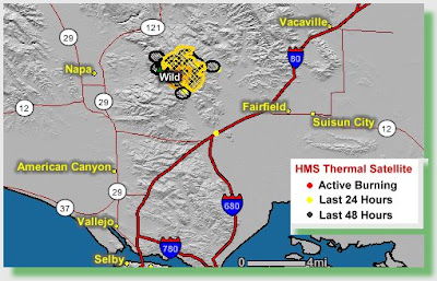
 Wild Fire
 California 2008 Summer Lightning Series Fires and Fire Complexes
Credit: Geomac wildland fire information viewer / Digital work-Screeshots: Cal Fire News
 Lime and Iron Fire complexes
California 2008 Summer Lightning Series Fires and Fire Complexes
Credit: Geomac wildland fire information viewer / Digital work-Screeshots: Cal Fire News
 Mariposa Complex Fire perimeters
California 2008 Summer Lightning Series Fires and Fire Complexes
Credit: Geomac wildland fire information viewer / Digital work-Screeshots: Cal Fire News
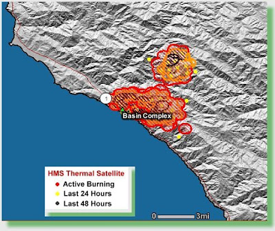
The Basin Fire burning in the Ventana Wilderness is currently unstaffed
Monterey Ranger District---Los Padres National Forest
June 24, 2008 9:00 AM
Los Padres NF Fire Information Center: (805) 961-5770 (8:00am to 8:00pm)
Public Meeting: Tonight at 7 PM at the Big Sur Visitor Center/Multi-Agency Facility
Fire location: One mile south of Big Sur, Los Padres National Forest
Date/time started: June 21, 2008 / 12:56 pm Total acres burned: approximately 8,500
Percent contained: 3% Fire line to be constructed: unknown
Expected containment: not determined
Expected control: not determined
Structures damaged/destroyed: 16 Residences 2 Out-Buildings
Cause: lightning
Staffing: Engines- 70, Crews-13, Dozers- 6, Air Tankers- 5, Helicopters- 3 , Total Personnel- 380
Terrain/vegetation/difficulties
Current situation: The Gallery Fire (6,350 acres) burned actively during the night at upper elevations on the eastern flank into the South Fork of the Big Sur River drainage. The Basin Fire continues to burn south and east toward the Tassajara Hot Springs Resort area and into the Big Sur River drainage. Officials anticipate the Gallery and Basin Fires will merge into a single fire as soon as today. The Basin Fire burning in the Ventana Wilderness is currently unstaffed. Structure protection engines were in place along Partington Ridge, the North Coast Ridge Road and Highway 1. Crews are holding the fire east of Highway 1 and south of the Community of Big Sur. However, the north, south, and east flanks of the fire remain open and active.
Evacuations: Approximately 75 residences and businesses were evacuated by Monterey County Sheriff's deputies Saturday night between Partington Ridge and Graves Canyon. Should further evacuations be required the Red Cross is prepared to open an evacuation center in Carmel.
Closures and road status: Highway 1 remains closed between the Ventana Inn on the north and Julia Pfeiffer Burns State Park on the south. Julia Pfeiffer Burns State Park is closed. Several businesses along Highway 1 in the fire area are closed. All national forest lands north of Nacimiento-Ferguson Road are closed to public access.
Agencies: U.S. Forest Service, CAL FIRE, Big Sur Volunteer Fire Department, California State Parks, California Highway Patrol, CalTrans, Monterey County and other agencies.
Incident Management: California Interagency Incident Management Team 5 under the command of Mike Dietrich assumed command of the Basin Complex at 6:00 a.m. today. The incident is being managed under a Unified Command with Chief Frank Pinny of the Big Sur Volunteer Fire Department and the Monterey County Sheriff. An incident command post has been established at Andrew Molera State Park.
Source: .pdf
California 2008 Summer Lightning Series Fires and Fire Complexes
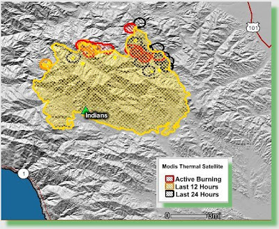
Indians Fire - Monterey Ranger District- Los Padres National Forest
June 24, 2008 6:00 AM
Los Padres NF Fire Information Center: (805) 961-5770 (8:00am to 8:00pm)
Basic fire information is posted at: www.inciweb.org and www.fire.ca.gov
Inciweb has been experiencing technical difficulties and cannot be updated regularly. Until the problem is resolved, information will be posted under “Current Conditions” at http://www.fs.fed.us/r5/lospadres
Date/time started: June 8, 2008 / 12:36 pm Total acres burned: 57,943
Percent contained: 66% Fire line to be constructed: 21 miles
Expected containment: 07/03/08 Expected control: not determined
Suppression costs to date: $29,900,000 Structures threatened: 1,063 residences, 265 other
Cause: escaped campfire Firefighters injured to date: 10
Residences destroyed: 2 Outbuildings destroyed: 13
Terrain/vegetation/difficulties: steep rocky terrain; heavy fuels—chaparral, grass, trees; limited access; drought conditions; dry gusty winds.
Personnel and equipment:
Crews- 64, Engine- 62, Helicopters- 13, Air Tankers- 5, Dozers- 9, Total Personnel- 2,037
Fire activity last night: Crews finished building line north toward Vaquero Creek. The southeast flank is in mop-up and patrol status. Some hotspots persist on the southwest corner where access is a problem due to terrain, but this area of the fire not expected to become active.
Today’s expected activity: Firing operations will take place today on the west side of the Indians fire near the Arroyo Seco area. Smoke shading from the Basin Complex fires may delay the firing operations this morning.
Weather predicted for today: At/below 2000’: 83-90 degrees, 12-20% relative humidity, winds light in the morning becoming upslope-up valley 3-7 mph in the afternoon. Above 2000’: 75-83 degrees, 5-10% relative humidity in the morning and then rising to 15-25% by noon then gradually lowering back to 10-15% through the afternoon, winds northwest 10-19 mph with a few gusts to 10 mph.
Evacuations: The Arroyo Seco area is under voluntary evacuation. Access is restricted to residents and property owners. A large animal advisory is in place for Arroyo Seco Road and Reliz Canyon Road. This advisory recommends the removal of large animals and livestock from areas along the west side of Reliz Canyon Road and Arroyo Seco Road between the Elm Street bridge and the Arroyo Seco Recreation area. The evacuation for cabins in the Santa Lucia Tract and six residences on private land at the north edge of Fort Hunter Liggett remain in effect. The voluntary evacuation notice for upper Pine Canyon has been lifted. An evacuation advisory remains in place for residents of upper and lower Pine Canyon and Thompson Canyon. The evacuation center in King City will be open from 10AM – 1PM.
Closures and road status: Arroyo Seco road is closed to the public from the junction of Arroyo Seco and Carmel road to the west. All national forest lands north of the Nacimiento-Ferguson Road are closed to public access. Arroyo Seco-Indians and Cone Peak Roads are closed. Pine Canyon Road (at end of pavement) and Reliz Canyon Road at Elm, are closed except to residents. Memorial Campground, Escondido Campground, Arroyo Seco Campground and Day Use Area are closed. Nacimiento-Ferguson Road is open, as well as coastal campgrounds and day use areas south of this road.
Due to the Basin Complex (Gallery and Bear Basin fires) near Partington Ridge on the Big Sur Coast and Bear Basin campground, Highway 1 is closed between the Ventana Inn on the north and Julia Pfeiffer Burns State Park on the south. (See Basin Complex fire update.)
Agencies: U.S. Forest Service, CAL FIRE, Fort Hunter Liggett, Bureau of Land Management, Monterey County and other cooperators.
Incident Commanders: Unified Command with Bill Molumby (California Interagency Incident Management Team 2); Rick Hutchinson (CAL FIRE); Chief Mike Crum (Fort Hunter Liggett).
Incident Command Post location: Fort Hunter Liggett
Information Office at Incident Command Post: (916) 366-5977, ext. 76003. Media access on Fort Hunter Liggett is restricted; all media must be escorted by a Public Information Officer (PIO). Contact PIO Steve Kliest regarding access and media tours. All media should wear personal protective clothing (Nomex shirt and pants, hard soled shoes, and hard hat) to access the fire line.
 Whiskeytown and Shu lightning Complexes
California 2008 Summer Lightning Series Fires and Fire Complexes
Credit: Geomac wildland fire information viewer / Digital work-Screeshots: Cal Fire News
6/24/08 | 1030 | Team Commitments
|
6/24/08 | 0855 | Corral CA-LMU 250ac 5% containment |
6/24/08 | 0600 | Popcorn CA-LMU 3100ac 25% containment |
6/24/08 | 0600 | Hells Half Complex CA-SRF 637 ac 2% containment |
6/24/08 | 0600 | Orleans/Ukonom CA-SRF 500ac 3% containment |
6/24/08 | 0600 | MNF Complex CA-MNF 2800ac 5%containment |
6/24/08 | 0600 | Peterson CA-LNF 2000ac 0% containment |
6/24/08 | 0600 | Yuba River Complex CA-TNF1750 ac 5 % contaiment |
6/24/08 | 0600 | American River Complex CA-TNF1200ac ac 5 % containment |
6/24/08 | 0600 | Walker CA-LNU 8600 ac 5% containment |
6/24/08 | 0600 | BLUE CA-SRF 70 ac 0% containment |
6/24/08 | 0600 | Whisytown Complex CA-WNP 750ac 0% containment |
6/24/08 | 0600 | TGU Complex CA-TGU 4629ac 15% containment |
6/24/08 | 0600 | IRON Complex CA-SHF 1060 ac 5% containment |
6/24/08 | 0600 | LIME Complex CA-SHF 7000ac 10% containment |
6/24/08 | 0600 | SHF Complex CA-SHF 22 ac 60% contaiment |
6/24/08 | 0600 | Canyon Complex CA-PNF 3300ac 0% containment |
6/24/08 | 0600 | Foresthill CA-NEU 75ac 90% containment |
6/24/08 | 0600 | WILD CA-LNU 4089 ac 80% containment |
6/24/08 | 0600 | LNF complex CA-LNF 500ac 0% containment |
6/24/08 | 0600 | Popcorn CA-LMU 2500 ac 0% contaiment |
6/24/08 | 0600 | LMU complex CA-LMU 50 ac 80% containment |
6/24/08 | 0600 | SHU Complex CA-SHU 8000 ac 5 % containment |
6/24/08 | 0600 | White hurst CA-SCU 200 ac 95% containment |
6/24/08 | 0600 | Mendocino Lightining Complex CA-MEU 13,000 ac 0% containment |
6/24/08 | 0600 | Humbolt Coplex CA- HUU 950 ac. 40 % containment |
6/24/08 | 0600 | BTU Complex CA-BTU 3900 ac 5 % containment |
6/24/08 | 0600 | Mad Complex CA SRF 1000ac. 40 % containment |
6/24/08 | 0600 | Yuba River Complex CA TNF 1925 ac. 5% containment |
6/24/08 | 0600 | Cub Complex Ca LNF 1300 ac. 0% containment |
6/23/08 | 1245 | Fire Near Concow has crossed Highway 70 east of Jarbo Gap into the Feather River Canyon. Town of Concow will have to be evacuated.5 Acre spot fire has landed near the town of Paradise. . Immediate need order has been placed for 25 Engine strike teams. |
Southern California GACC News and Notes:
| 6/24 | 0730 | Oliver Complex (CA-SNF-0715 ) 1292 Acres, 5% contained. |
| 6/24 | 0730 | Mariposa Complex (CA-MMU- 008048), 2500 Acres, 100% contained. |
| 6/24 | 0700 | Brown (CA-BEU-002390) Demob this morning begining at 0800. |
| 6/24 | 0700 | Basin Complex (CA-LPF-1649) 7,025 Acres, 3% contained. |
| 6/24 | 0600 | North Mountain (CA-STF-1063) 605 Acres, 5% contained. |
| 6/24 | 0600 | Indians (CA-LPT-1491) is now at 57,943 acres and is 66% contained. |
| 6/23 | 2030 | Oliver Complex (CA-SNF-0715 ) The NIMO team IC Tom Cable took over the incident tonight at 2000 hrs. Incident is in Unified Command with Madera Mariposa Unit Cal Fire with the unified ordering point as Sierra NF . Yosemite High School in Oakhurst is the projected Incident Command Post. This incident was formerly cited under ABC Misc June Lightning (CA-SNF-0715). Acreage breaks out as follows: OLIVER=1000 Acres, 0% contained; WESTFALL =50 Acres, 50% contained; SILVER= 400, 10% contained; STAR= 30 Acres, 0% contained; CHIQUITO=10 ACRES, 50% contained; The GAGG, POISON and 7 other fires are confined but not yet controlled. |
| 6/23 | 1900 | Brown (CA-BEU-002390) 3,870 Acres, 100% containment. Fire laid down today. All line construction is complete and the fire was declared contained at 1700 Hrs. |
| 6/23 | 1900 | Valley (CA-RRU-055557) 20 acres, containment anticipated circa 2000 hrs. this evening. |
| 6/23 | 1900 | Effective 1900 hrs todays date The Southern California Gragraphic Coordinations Center has moved to MACS mode 3 and will be re-evaluated each operational period with conference calls schedualed as needed based on significant activity. |
| 6/23 | 1800 | Basin Complex (CA-LPF-1649) 7,025 Acres, 3 % contained. Active backing fire entered into the South Fork of the Big Sur River . Fuels are highly receptive to spotting. The Logwood fire has been consumed by the Gallery fire. The Complex now has two fires. The Gallery fire is 5920 acres with 10% containment. The Basin fire is 1105 acres with 0% containment. Possible 5 structures/outbuildings have been damaged in last 24hrs. Confirmation is an ongoing effort. Co-operating agencies include Caltrans, CHP, Sheriff, and The Red Cross. |
| 6/23 | 1800 | Clover (CA-SQF-0967) 13,749 Acres, 10% contained Public interests continues as fire activity continues. Smoke continues to impact the community of Kennedy Meadows. |
| 6/23 | 1800 | Indians (CA-LPT-1491) is now at 57,745 acres and is 66% contained. Active fire behavior includes single and group tree torching. Firing operations are negatively impacted by smoke from the Basin Complex. |
| 6/23 | 1500 | North Mountain (CA-STF-1063) 550 Acres, 0% contained, located near North Mountain 7mi. NE of Groveland. 200 residences are threatened. Seasonal camp dwellings (Camp Mather andCamp Tuonga ) South of the Tuolumne River are potentially threatened if the fire spots across the river. Major problems are steep and inaccessible terrain and long travel distances for crews. Today's observed fire behavior included short runs with moderate range spotting. |
| 6/23 | 1300 | Cajon (CA-BDF-6944) 100 Acres, 0% contained. The fire is adjacent to Hwy 115 and is burning below high voltage electrical transmission lines in Chaparral (6 Feet) on medium difficult terrain. Observed weather behavior: High Temp. of 91 deg., RH 20% , and Winds ESE with peak gusts reaching 14 MPH. |
Update of the day: Gov. Arnold Schwarzenegger said he was told late Sunday evening that the state had 520 fires, and he found it "quite shocking" that by Monday morning the number had risen above 700.
Moments later, a top state fire official standing at Schwarzenegger's side offered a grim update. The figure was actually 842 fires, said Del Walters, assistant regional chief of the California Department of Forestry and Fire Protection. All but a couple were in the northern part of the state.
"This is an unprecedented lightning storm in California, that it lasted as long as it did, 5,000 to 6,000 lightning strikes," Walters said. "We are finding fires all the time."


No comments:
Post a Comment
CAL FIRE NEWS LOVES COMMENTS...
- Due to rampant abuse, we are no longer posting anonymous comments. Please use your real OpenID, Google, Yahoo, AIM, Twitter, Flickr name.