Monday, June 20, 2016

CA-MVU Border Fire, vegetation, San Diego County, CAL FIRE San Diego Unit SRA [MAP]

Border Fire, vegetation, San Diego County, CAL FIRE San Diego Unit SRA

Brush fire with threat to the WUI

Location: off Highway 188 and Highway 94 near Tecate, 2 miles west of Potrero
San Diego County SRA
Fuels: grass, brush

Updates:
 
06/25/16 0830: 7,609 acres, grass, brush, 70% contained. Cal Fire IMT 5 (Bravo) in command
SRA
  • Minimize the impacts to the BLM wilderness study area, surrounding
    communities, protect cultural and archeological resources.
  • Minimal fire growth is anticipated.
  • Traffic control points remain in effect at; Harris Ranch Rd x Potrero, and
    Hwy 94 x Martin Rd.

06/24/16 1930: 7,609 acres, grass, brush, 60% contained.


  • Minimize the impacts to the BLM wilderness study area, surrounding
    communities, protect cultural and archeological resources.
  • Minimal fire growth is anticipated.

  • Traffic control points remain in effect at; Harris Ranch Rd x Potrero,
    Hwy 94 x Martin Rd., and Volmer Rd. x Hwy 94.


  • 06/23/16 0830: 7,483 acres, grass, brush, 45% contained
    Cal Fire IMT 5 (Bravo) in command SRA
    • Minimize the impacts to the BLM wilderness study area, surrounding
      communities, protect cultural and archeological resources.
    • Fire continues to make significant runs when in alignment with
      fuels and topography.
    • Evacuation center at Los Coches Elementary School
    • All evacuation orders are lifted
    • Traffic control points remain in effect at; Harris Ranch Rd x Potrero,
      Hwy 94 x Martin Rd., and Volmer Rd. x Hwy 94.

    06/22/16 0930: 6,723 acres and 20 percent contained. Five homes total were destroyed; two of the homes were primary dwelling units and three homes were second dwelling units/guest houses.  
    More than 1,900 firefighters are assigned to the wildfire.
    The Campo-Morena Village Library remains closed due to the Border Fire.
    An American Red Cross shelter is still available at Los Coches Creek Middle School, located at 9669 Dunbar Ln., El Cajon, CA.  It will be open again overnight and will remain open as long as needed. Small pets are welcome.
    Evacuations: Community of Potrero is under mandatory evacuations.
    Evacuation Shelter: Red Cross has opened up a shelter at Campo Elementary School (1654 Buckman Springs Road)
    Road Closures : Highway 94 is closed 

    06/21/16 0930: 7,500 acres, grass, brush, 5% contained.
    • Mandatory evacuation for community of Potrero
    • Road closure at Hwy 94 and Junction of Hwy 188 to Buckman Springs
    • Fire has burned into BLM managed land in the Hauser Mountain WSA.
    • Evacuation centers at Los Coches Elementary School for long term overnight
      evacuations and Golden Acorn Casino for immediate evacuations.
    06/20/16 1330: 7,500 acres, grass, brush, 5% contained., Cal Fire IMT 5 (Bravo) in command

    • Mandatory evacuation for community of Potrero
    • Road closure at Hwy 94 and Junction of Hwy 188


    06/20/16 1330: update: extreme fire behavior and activity. New evacs ordered for Forest Gate, Star Ranch, Cowboy Ranch, Dog Patch, Canyon City
    06/19/16 1900:  1,500 acres, 0% contained.

    · Mandatory evacuation orders for the community of Potrero

    · Threat to critical infrastructure
    · Hwy 94 is closed
    · FMAG process initiated

    Sunday, June 19, 2016

    CA-BEU King Fire, Vegetation Fire, Monterey County

    King Fire, CA-BEU-002815, Vegetation Fire, Monterey County

    Location: Hwy 198 x Peach Tree Rd. State DPA, SRA

    Updates:
    06/18/16 1900hrs: 237 acres, 80% contained

    • Heavy mop-up in drainages
    • One Federal Helicopter assigned

    Saturday, June 18, 2016

    CA-AEU Comanche Fire - Lake Comanche Vegetation Fire. FINAL 210 acres, 100% contained.

    Comanche Fire, CA-AEU-Camanche Amador County, Vegetation Fire
    The vegetation fire, is burning off of Camanche Parkway and Coal Mine Road.
    Coal Mine Road is closed.
    The fire was initially reported as 1/4 of an acre when it ignited around 2:50 p.m. Gusty winds helped spread the flames. By 7 p.m. the blaze was 40 percent contained.


    Location: Camanche Parkway North and Coal Mine Road - North Shore Camanche Lake.Acres: 40ROS: ModerateROC: Light flashy fuels. Multiple road side starts with 2 of the 3 fire contained.
    Updates: 

    06/21/2016 1900: FINAL 210 acres, 100% contained.
    06/20/2016 0800: 210 acres. 95% contained06/19/2016 0800: 210 acres of brush and grass. 85% contained.
    06/17/16 1900hrs: 200 acres and 40% contained. Mandatory evacuations are in effect for the China Gulch area. The Buena Vista area is under voluntary evacuations. Evacuees are being routed to the Church of Christ in Camanche.
    06/17/16 1700hrs: Gusty winds continue to challenge firefighters battling the Camanche Fire in Amador County. Fire is now 150 acres & 10% contained.
    06/17/16 1600hrs: 60 acres and 10% contained Mandatory evacuation for China Gulch, ST 9476G enroute from TCU.
    06/17/16 1500hrs: 1/4 of an acre

    CA-BEU King Fire, CA-BEU-002815, Vegetation Fire, Monterey County DPA. SRA

    King Fire, CA-BEU-002815, Vegetation Fire, Monterey County DPA. SRA

    Location: Hwy 198 x Peach Tree Rd
    State DPA, SRA
    Updates:
    06/17/16 1900hrs: 100 acres, 0% contained grass and oak woodlands
    • 2 out buildings destroyed
    • Continued threat to structures
    • Federal aircraft assigned

    Friday, June 17, 2016

    Pony Fire, CA-KNF-004500 Siskiyou County Pony Peak Forest Fire

     Pony Fire, CA-KNF-004500 Siskiyou County Pony Peak

    Location: Siskiyou County Pony Peak, California 96039, FRA

    Terrain: Steep terrain with extremely difficult access. Long transport times to advanced medical care. The fire is burning in an old fire scar with an extreme snag hazard. Roads are narrow with limited access. Road controls are essential for safe travel around the fire area. 

    Cultural resources: prodgeny sites, Spotted Owl habitat, endangered Coho salmon spawning areas, summer run steelhead in Dillon Creek & Crawford project areas. 

    Updates: 

    06/20/2016 1300: 2877 acres, 60% contained. Minimal fire activity observed. http://gacc.nifc.gov/oncc/predictive/intelligence/lg_fire_summary/Large_Fire_Summary.pdf

    06/18/2016 1738:
     2826 acres, 55% contained.
    Today's fire spread is minimal. Isolated pockets of heat continue to burn in the heavy concentrations of the dead and down. As clear skies have returned to the fire area, fuels are drying out and showing limited activity.
    06/17/2016 1750: 2826 acres, 40% contained. Rainfall in amount and duration has been effective in halting fire spread and reducing any fire activity to smoldering area. Fire continues to be moderated by a low pressure system

    06/16/2016 1750:
    2806 acres, 25% contained.

    06/15/2016 1755: 2706 acres, 20% contained. The fire continues to hold in creek beds where direct tactics have been effective. A much colder air mass with higher relative humidity moved into the area and will continue through the rest of the week.

    06/15/2016 0930: National Weather Service-Reno has a High Wind Advisory for Lassen, Eastern Plumas, Eastern Sierra Counties for strong southwest winds from 1400 today through 2300 this evening.  Additionally, there is a Red Flag Warning in place for the Western Nevada Sierra Front for strong southwest wind 20-30 miles per hour with gusts to 50 miles per hour. This warning is in place from 1100 this morning through 2300 this evening. http://forecast.weather.gov/wwamap/wwatxtget.php?cwa=sto&wwa=red flag warning

    06/14/2016 1805: 2,396 acres, 20% contained. Fire behavior moderated with increased relative humidity values and decreased temperatures.

    06/14/2016 0630: 2,396 acres, 20% contained. Fire behavior moderated overnight under the influence of the incoming cold front. Crews, overnight held existing fire lines and improved lines where feasible.

    06/13/2016 1810: 2096 acres, 20% contained. Lower temperatures and higher relative humidity moderated fire behavior today.

    06/13/2016 0600: 2096 acres, 20% contained. Fire activity remained moderate over night. For additional information please select the Fire Infomation Summaryhttp://gacc.nifc.gov/oncc/predictive/intelligence/lg_fire_summary/Large_Fire_Summary.pdf

    06/12/2016 0600: 1655 acres, 20% contained. Fire remained active over night. For additional information select the Fire Information Summary


    Tweet

    Thursday, June 16, 2016

    Missing Persons: Tuolumne County Pinecrest Area - Hikers and Dog Missing

    Missing in Tuolumne County especially near Pinecrest. and anyone else that has been in the area in the last 5 days.

    Please share this post and look closely at the pictures. If you see them please call the Sheriff's Office immediately at 209-533-5815 with an approximate location.

    TWO MISSING HIKERS FOUND SAFE!!!!!

    Updates:06/17/16 1430hrs - Donna and Mark hiked at least 60 miles. Their original hike plan was diverted due to terrain and a large amount of snow. They became lost on Tuesday and continued to use their map to try and find alternate routes. We are glad they are healthy and safe! We want to extend a huge thank you to all of the Departments and amazing Search and Rescue teams who put in long hours around the clock to see that these two and all who need help are safe.

    Updates:06/17/16 0800hrs - The search for the missing hikers has resumed this morning. 

    Multiple agencies including Stanislaus County, Calaveras County, Alpine County, Monterey County, Contra Costa County, El Dorado County, Marin County, Mono County, Forest Service and the National Guard have joined the search. The rescuers have extensive training for in climate weather and treacherous terrain. The Stanislaus County Sheriff's helicopter is in the air this morning flying over the trail area and surrounding areas with two more additional helicopters joining the search at 9 AM. 

    The emigrant wilderness search area is very large with various terrains including steep granite, meadows, valleys, creeks and snow. There are 4 scent dogs and 1 trail dog being utilized in the search. Updates will be posted throughout the day.

    Updates:06/16/16 2000hrs - Per Tuolumne County Sheriff The search for Donna and Mark, the missing hikers, will resume tomorrow at day break.

    Tuolumne County Sheriff added 6 new photos.
    5 hrs
    *TWO MISSING HIKERS*
    Donna Hallberg
    WFA
    55 years old
    Modesto Resident
    5'08, 130 pounds
    Short brown hair
    Brown Eyes
    Last seen wearing capri workout pants, a black jacket and carrying a blue backpack.
    Donna has a tattoo on the back of her neck, "Live Life."
    Mark Smallwood
    WMA
    59 years old
    Modesto Resident
    6'00
    190 pounds
    Brown hair
    Donna and Mark also have a black and white dog with them, pictured below.
    The two experienced hikers left on Sunday the 12th to hike the Crabtree Trail Head to Lake Gem and the Long and Deer Lakes near the Dodge Ridge, Pinecrest area.
    They parked their gray Chevy Tahoe at the Crabtree trail head and have not returned to their vehicle.
    A friend called the Tuolumne County Sheriff's Office Wednesday afternoon when the two did not return Tuesday as scheduled. Donna and Mark are experienced hikers who have hiked the trail numerous times in the past. The friend told Deputies that the pair have enough supplies and equipment for at least the three days they planned to be in the outdoors. Donna and Mark do have cell phones but due to the lack of service in the area their location was not able to be tracked.
    Our Search and Rescue Team along with the CHP Helicopter are searching the area currently.

    CA-INF- Ash Fire, CA-INF-000885, Wildland Fire, Inyo National Forest, FRA

    Ash Fire, CA-INF-000885, Wildland Fire, Inyo National Forest, Inyo County, FRA

    Location: Ash creek drainage, Inyo County, FRA
    Start Time: 06/12 @1408

    Updates: 


    06/20/2016 1900: 110 acres, 0% Contained


    06/17/2016 1900: 110 acres, 0% Contained.
    • Rate of spread low, with rough accessibility.
    • 2 Federal helicopters committed.
    • No ground resources committed at this time.
    • Will pursue confine/ contain strategy.


    06/17/2016 0915: 110 acres, 0% Contained
    • Rate of spread low, with rough accessibility.
    • 2 Federal helicopters committed.
    • No ground resources committed at this time.
    • Will pursue confine/ contain strategy.

    06/16/2016 1115: 09 acres, 0% Contained
    Rate of spread low, with rough accessibility.
    70°, 28 % RH, 6 mph.
    • 2 Federal helicopters committed.
    • No ground resources committed at this time.
    • Will pursue confine/ confine strategy.
    06/16/2016 1115:  Approx.. 60 acres
    Fire began several days ago and has slowly increased in size. In inaccessible terrain. Fire is in confine and contain status at this time.
    A helitanker and Ty3 helicopter are the only resources currently working this incident.

    CA-LPF Sherpa CA-LPF-001643, Vegetation fire, Santa Barbara County [MAP]

    Sherpa Fire, CA-LPF-001643, Vegetation fire, Santa Barbara County

    The fire is being managed under Unified Command by the US Forest Service, Cal Fire, and Santa Barbara County Fire Department. The fire has exhibited extremely fast downhill runs during evening and overnight hours due to downslope Sundowner winds. It is anticipated that this type of fire behavior will continue each night as long as Sundowner weather conditions continue. 

    Location: 11 miles north of Goleta, Camino Cielo Ridge, Los Padres National Forest
    Start Time: 15:30 hrs

    Sherpa Fire 6-17-16
    Credit: +SLOStringer 

    Updates: 
    06/22/2016 0930: 7,969 acres and has 89% containment. There are 1,678 personnel assigned to the incident.

    06/21/2016 0930: 7,969 acres, 70% Contained (FRA=3420 acres, SRA=4549 acres)
    • Extreme topography may limit direct line construction
    • Most mandatory evacuations will be reduced to warnings on 06/22/16 @ 0500.
      Some areas will have continued restrictions.
    06/20/2016 1930: 7,893 acres, 62% Contained. Extreme topography may limit direct line construction.
    Overall fire behavior was moderate with little growth, yet the fire still has the potential to increase in activity and grow quickly. Aviation resources are being used to slow the fire growth in this area providing hand crews and dozers with the time needed to complete direct containment and secondary contingency lines .Fixed wing air tankers remain available if fire activity does increase.
    Although a Red Flag Warning remains in effect until 10 a.m. Tuesday, weather is beginning to moderate with cooler temperatures expected.
    Highway 101 is currently open; residents and motorists may check current conditions on Highway 101 by clicking on the Department of Transportation


    Most mandatory evacuations within the Sherpa Fire will be reduced to evacuation warnings on June 22 at 5 a.m. Some areas will have continued restrictions. Please see the following link for the Repopulation Plan: INCIWEB - http://inciweb.nwcg.gov/incident/4786

    ***A RED FLAG WARNING REMAINS IN EFFECT UNTIL 1000 TUESDAY***

    The probability of ignition is 100% at elevations greater than 800 ft. above sea level (inversion layer) and 80-90% on lower elevations & beaches.

    Due to extremely high temperatures and heat related emergency evacuations, a Safety Stand Down was implemented for one hour. All ground personnel were instructed to rest and hydrate.

    The fire is being managed under Unified Command by the US Forest Service, CAL FIRE and Santa Barbara County Fire Department.

    Ownership = FRA 3344 acres, SRA 4549 acres

    The San Dimas Technology Development Center in conjunction with California Interagency Incident Management Team 4 is performing a Fire Retardant Effectiveness Study.

    Sherpa, Vegetation fire, Santa Barbara County

    06/20/2016 1330: 7,893 acres; 54% contained.


    06/19/2016 1900: 7893 acres, 51% Contained. 
      Fire ownership by acres: State Responsibility Lands=4549; Forest Responsibility Area=3344.
    • Type 2 Team (Mills) closed out 1200 hrs. today.
    • Sundowner winds were observed over portions of the fire with gusts up to 55 mph.  Sundowner conditions are expected to persist through Monday.
    • Crews were successful in protecting residential property in the El Capitan Canyon area, El Capitan State Park and along the Highway 101 corridor.

      Evacuations:
    • Mandatory Evacuation orders: remain in effect for Refugio Canyon, Venadito Canyon, Las Flores Canyon, El Capitan Canyon, El Capitan State Beach, El Capitan Ranch, and Canada de la Destiladera; and the area east of the Refugio burn area up to Calle Lippizana, near the equestrian center. ·

      Evacuation Warning:
      is in place for the areas east of El Capitan Canyon to Farren Road; Las Llagas Canyon, Gato Canyon, Las Varas Canyon, Dos Pueblos Canyon, and Eagle Canyon · Fire department overnight priorities: 60 homes in Refugio Canyon, 80 homes in El Cap Ranch, Circle Bar B & “the Narrows”

      The Santa Barbara Red Cross has activated an evacuation shelter for those effected by the Sherpa Fire. which is located at the Wake Center within the Santa Barbara City College, 300 N. Turnpike Road in the city of Santa Barbara.

      Individuals with pets and livestock may contact Animal Service at 805-681-4332
      Fire behavior: Moderate ROS, Flanking fire with Isolated Torching
      Overall fire behavior was moderate yet the fire still has the potential to increase in activity. Observed fire behavior included short runs along the north and east open line with isolated consumption of unburned fuels within the perimeter. Crews continue to make good progress in securing the west flank. Fire continues to flank, moving up Corral Canyon and on the Santa Ynez Peak to the east.
      Sundowner winds picked up at approximately 1600 with the wind shifting to down canyon. Once weather conditions become more favorable probability of containment of the east flank will increase. The fire has exhibited extremely fast downhill runs during evening and overnight hours due to downslope Sundowner winds. It is anticipated that this type of fire behavior will continue each night as long as Sundowner weather condition continue. Sundowner conditions are expected to persist through Monday.
      Resources assigned: 1,926 people, 129 engines, 13 water tenders, 61 hand crews, 14 dozers, 18 helicopters, and 5 air tankers including the DC-10.
      The San Dimas Technology Development Center in conjunction with the California Interagency Incident Management Team 4 is performing a Fire Retardant Effectiveness Study.

    06/18/2016 1930: 7811 acres, 45% Contained
    • Extreme down slope runs is expected tonight due to Sundowner winds.
    • The fire continues to move up Corral Canyon and Santa Ynez Peak to the east.
    • The threat to the Oil refinery has been abated.
    • Type 2 Team (Mills) close out 1200 hrs., 06192016
    06/18/2016 1130:  LAFD sending one(1) Strike Team (5 engines w/chief) to "Sherpa" fire in Santa Barbara County;  E8139 E8140 E8138 E8137 E8136 BC738 BC741 410 evacuation contacts are made through the Sheriff's office reverse 911 program. 
    AT-910 dropping a load of mud on the Sherpa Fire 6/17
    Credit: 10 Tanker Air Carrier Facebook


    06/18/2016 0900: 7063 acres, with 24% containment. Crews continue to make good progress along the west flank with black line. Fire continues to move up Corral Canyon and on the San Ynez Peak to the east. The fire continues to flank toward the east and south east.

    The significant Sundowner winds did not surface as expected last night. Crews took advantage of the weather and continued with direct line construction.

    Today firefighters will continue to work on building and reinforcing containment lines along the North and East sides of the fire, and along Highway 101. Crews will continue with contingency lines on the East side of the fire.

    Fire activity along Highway 101 is under continuous evaluation by fire managers and the California Highway Patrol. The Hwy may be closed again if the fire is determined to be a hazard to motorist.

    The communities surrounding the Sherpa Fire can expect to see smoke throughout the day, which will increase during the evening hours. Outdoor activities should be planned for times when smoke levels are low.

    Evacuations:· Mandatory Evacuation orders: remain in effect for Refugio Canyon, Venadito Canyon, Las Flores Canyon, El Capitan Canyon, El Capitan State Beach, El Capitan Ranch, and Canada de la Destiladera; and the area east of the Refugio burn area up to Calle Lippizana, near the equestrian center.

    · Evacuation Warning: is in place for the areas east of El Capitan Canyon to Farren Road; Las Llagas Canyon, Gato Canyon, Las Varas Canyon, Dos Pueblos Canyon, and Eagle Canyon

    · Fire department overnight priorities: 60 homes in Refugio Canyon, 80 homes in El Cap Ranch, Circle Bar B & “the Narrows”

    Sherpa Fire Perimeter Map

    06/17/2016 1900: 5866 acres, 20% Contained
    • A Transition to Type 1 Team (Opliger) at 1800, 6/18/2016
    • A threat to Broadcast Peak Communication towers,
      El Capitan California State Park and residential property in
      El Capitan Canyon.
    • Fire continues to move up Corral Canyon and on the San Ynez Peak to the east
    • Fire exhibited extremely fast downhill run during evening and overnight hours do
      to downslope Sundowner winds. This behavior will continue each night as the
      Sundowner weather continues.
    • Crews were successfully able to protect residential property in the El Capitan canyon
      area and El Capitan State Beach
    • Federal air and ground resources and CAL FIRE air resources assigned

    06/17/2016 0830:  4000 acres, 5% Contained
    • Threat to large oil refinery, Broadcast Peak Communication towers,
    • El Capitan California State Park and residential property in El Capitan Canyon, Section of Hwy 101 (from Buellton to Winchester Dr.) was reopened at 0400 this morning.
    • Southern Pacific railway was reopened to traffic at 2300 last night.
    • Federal air and ground resources and CAL FIRE air resources assigned
    06/16/2016 0800: 1250 acres, 0% Contained
    Type 3 IC in command.
    • Threat to an Oil refinery, Hwy 101, Broadcast Peak major Communication towers,
    • and California State Parks.
    • Type 2 IMT (Mills, with Laeng-Training) has been ordered.
    • 2 VLATs assigned
    • Evacuations remain in place.
    • Commitment of Federal air and ground resources.
    06/15/2016 1730: 60 acres, 0% Contained
    Moderate rate of spread
    76°, 50 % RH, 5 mph, W
    Federal air and ground resources and CAL FIRE air resources assigned
    1 VLATs assigned
    Structures threatened
    Santa Barbara County has Mandatory and Voluntary Evacuations in place.

    06/15/2016 1700: 60 acres, 0% Contained.
    • · Moderate rate of spread
    • · 76°, 50 % RH, 5 mph, W
    • · Federal air and ground resources and CAL FIRE air resources assigned
    • · 2 VLATs assigned
    • · Structures threatened

    FBI and Stanislaus County Law Enforcement Seeking Information Regarding Arson At Modesto Woman's Health Clinic

    Unknown Suspect(s)

    ARSON INVESTIGATION - MODESTO, CALIFORNIA

    Subject Image
    Planned Parenthood Clinic (Post-Repair)

    DETAILS

    The FBI and local law enforcement authorities in Stanislaus County, California, are seeking information regarding the arson of a woman's health clinic in Modesto. On May 25, 2016, at approximately 3:30 a.m., local police and fire department officials responded to a fire alarm at the Planned Parenthood Clinic located at 1431 McHenry Avenue in Modesto. Although the fire suppression system inside the building extinguished the flames, the entry and façade of the building sustained substantial fire damage. Approximately one third of the building also sustained water damage. Subsequent investigation at the scene indicated an incendiary device had been thrown through the clinic's glass front doors.

    REWARD

    The FBI is offering a reward of up to $2,500 for information leading to the arrest and conviction of those responsible for the arson.
    If you have any information concerning this person, please contact your local FBI office or the nearest American Embassy or Consulate.
    Field Office: Sacramento

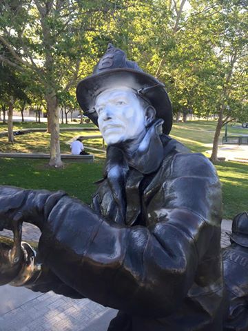
    Stockton Fire Department Fallen Firefighters Memorial Desecrated

    Stockton Fire Department Fallen Firefighters Memorial
    Graffiti Damage

    It was a busy weekend for the Stockton Fire Department.

     While firefighters responded to six working structure fires, several vehicle accidents (pulling two victims from one on HWY 4), extinguishing almost a dozen vegetation fires, successfully assisting PD in the surface rescue of a fleeing suspect, providing ALS paramedics to a shooting at Oak Park and several other stabbings and assaults, and responding to literally hundreds of others calls- while all that was happening....

    The hallowed ground that is The Fallen Firefighters Memorial was desecrated and graffiti spray painted and tagged- this is an incredible insult to our servicemen who literally put their lives in jeopardy every day; and to the memorial that symbolizes the remembrance of those who made the ultimate sacrifice in service to the citizens and City of Stockton.

    Firefighters worked diligently to remove the paint yesterday, but could not get it all. Fortunately (or unfortunately that they had to be there at all), the company Stockton Monuments was scheduled to replace the main plaque (previously stolen) and happen to be on scene. The employees and owner went above and beyond to assist in chemically treating the graffiti, pressure washing, and removing all paint- in time for our Academy Graduation tomorrow.
    Stockton Fire Department Fallen Firefighters Memorial
    All cleaned up

    We want to thank Stockton Monuments for their service- we can not express how much it means to us to keep this monument clean. Our current Fire Academy detoured their morning run to put the finishing touches on the clean up. Our firefighters are proud to see her shine again.

    Info and Pictures from Stockton Firefighters Facebook
    Stockton Firefighters Local 456

    Twitter Buttons

    ****REMINDER**** Every fire has the ability to be catastrophic. The wildland fire management environment has profoundly changed. Growing numbers of communities, across the nation, are experiencing longer fire seasons; more frequent, bigger, and more severe, fires are a real threat. Be careful with all campfires and equipment.

    "I am a firm believer in the people. If given the truth, they can be depended upon to meet any national crisis. The great point is to bring them the real facts, and beer." --Abraham Lincoln

    View blog top tags
    ---------------------
    CLICK HERE TO GO BACK TO TOP OF CALIFORNIA FIRE NEWS HOME PAGE

    Subscribe via email to California Fire News - Keep track of Cal Fire News

    Enter your email address:

    Delivered by FeedBurner