Tuesday, October 6, 2015

Valley Fire Shelter Deployment SART - Green Sheet

GREEN SHEET


California Department of Forestry and Fire Protection (CAL FIRE) Informational Summary Report of Serious CAL FIRE Injuries, Illnesses, Accidents and Near Serious Accidents Valley Fire Shelter Deployment and Serious Burn Injuries September 12, 2015 Valley SART 15-CA-LNU-008670 15-CA-CDF-000580

California Northern Region A Board of Review has not approved this Informational Summary Report. It is intended as a safety and training tool, an aid to preventing future occurrences, and to inform interested parties. Because it is published on a short time frame, the information contained herein is subject to revision as further investigation is conducted and additional information is developed. 

Valley SART - Green Sheet

SUMMARY
This Informational Summary Report references, on Saturday, September 12, 2015, at approximately 1402 hours, one helitack fire captain and three helitack firefighters suffered serious burn injuries after becoming entrapped and then deployed their fire shelters on the Valley Incident, in Lake County, California.

CONDITIONS
Konocti Remote Automated Weather Station, approximately 5.5 miles north east of the burnover location at 1400 hours;   
 Temperature: 88° 
 Relative Humidity: 12% 
 Wind: West 18 mph, gusts of 30 mph 
 Fuel Moisture: Chamise 51%, fine dead fuels 3% (unshaded) 
 Probability of Ignition: 89%
Fuel Type Conifers intermixed with hardwoods, pockets of Manzanita and Chamise.
Size of brush: 6 foot plus, south of the deployment site.
Road Conditions: Clear, dry 
Topography: Multiple intersecting drainages with short, moderate to steep, slopes.
Fire Behavior: Approximately 110-130 acres with multiple spot fires resulting in understory burning with group tree torching and short crown runs driven by wind and/or slope alignment.

SEQUENCE OF EVENTS
On Saturday, September 12, 2015, at approximately 1323 hours, a helitack crew was dispatched to a vegetation fire as part of an initial attack wildland response. The vegetation fire was reported at 8015 High Valley Road, in Kelseyville, California. At approximately 1330 hours, the helicopter (C1) with two fire captains, six firefighter I’s, and one pilot lifted off from the Sonoma-Lake-Napa-Unit (LNU) helitack base.
 The front seat fire captain’s (FC1) report on conditions was: two acres in grass and oak woodland, a moderate rate of spread, with one structure immediately threatened and the potential to burn 20 acres. C1 crew observed short range spotting with some isolated tree torching. FC1 and FC2 determined the left flank of the fire would be their priority. C1 landed in a field near an access road which led to the fire’s left flank. When the helitack crew started a direct attack on the left flank towards a structure (RES1), FC2 advised FC1 they should stay mobile and provide structure defense. 
 At 1332 hours, a battalion chief arrived at scene and assumed Valley Incident Commander, (IC). Shortly after, the Air Attack (AA) and two air tankers responded from the local airbase. The AA immediately requested three additional multi-engine type 3 air tankers.
 FC1 told FC2 he was going to bump ahead of the helitack crew to scout. FC1 hiked across the black using a deer trail. After some time, FC1 told FC2, over the radio, to bump up. FC2 and helitack firefighters could see FC1 ahead of them as they approached a second residence (RES2). FC2 observed several spot fires and directed the helitack firefighters to assist FC1 in extinguishing the spot fires in the grass and on the wood deck surrounding RES2. FC2 started hiking up the driveway and told FC1 that he was going to bump further ahead. Without direction, FF1 and FF6 followed FC2 up the driveway (Helitack B) in search of more structures to defend. FC2 observed a spot fire spreading near RES2 on the west side of the driveway, and advised FF6 to watch the spot fire. FC2 also yelled to FF1 to hustle up to their location due to the additional spot fires which spotted over the driveway. 
 At approximately this time, FC1 directed FF2 to remain at RES2 for structure defense and told him to call on the radio if there were any issues. FC1, FF3, FF4 and FF5 (Helitack A) hiked cross country to the southeast toward a structure that was to their right on a ridge top.
 When they reached the ridge top FF3 observed spot fires advancing up the slope toward them. FF3 stood at the top as a lookout for a few minutes then met up with FC1, FF4 and FF 5. 
 The ridge top was under a canopy of pines and oaks but had very little low surface and ground level vegetation. Around the steel garage, was a 58 foot by 30 foot garden along the northwest (D) side of the steel garage, a 53 foot by 73 foot goat pen, and an eight foot wide dirt road running northwest/southeast separating the goat pen and garden.
 Soon after reaching the ridge top, FC1 directed FF5 to scout the southern side of a goat pen. FF5 hiked to the southwest side of the goat pen and observed a steep brush covered slope with no visible smoke or fire; the brush was approximately six to seven foot tall manzanita and chamise. 
 Helitack A observed increased spot fires in the pine needles and leaf litter along the southwest side of the goat pen. They started to extinguish the spot fires but there were too many. FC1 directed FF3, FF4 and FF5 to get into the goat pen, which was clear to bare mineral soil. While in the goat pen they observed the fire behavior changing. There was an increase in the wind speed, and an increased number of spot fires in the pine needle duff and leaf litter surrounding them. FF3 saw fire sheeting and swirling across the dirt driveway on the northwest side of the goat pen; several pines torched on the west side of the steel garage. From the location of RES2, FF2 observed increased fire behavior advancing toward Helitack A’s location. 
 FF2 communicated the increased fire behavior using the radio; FC1 acknowledged FF2’s observation. At approximately 1402 hours, the brush covered slope to their east completely torched into a wall of flame. The wall of flame sent a significant wave of radiant heat through the goat pen and onto the firefighters. They could feel their faces burning from the radiant heat and all four firefighters ran to the fence, climbed over, and ran towards the steel garage. At the steel garage Helitack A started to deploy their fire shelters. “May-Day” was transmitted from FC1 and was heard over the radio. From the location of a third residence (RES3), FC2 could hear FC1 say over the radio, “Four have deployed their shelters, near a barn on the right flank.”
 FF4 had difficulty opening the fire shelter case from the Chainsaw Pack; the clear plastic covering of the fire shelter was soft and melted. FF4 had to remove the gloves to tear the plastic away from the aluminum shell of the fire shelter. FF3 couldn’t get the fire shelter out of the case because the clear plastic cover was melted to the white plastic protective sleeve. FF3 looked up and saw FF4 at the north side (D) of the steel garage. FF3 dropped the fire shelter on the ground and ran to FF4’s location. FF3 and FF4 shared FF4’s fire shelter and stayed together in a crouched position.
 FC1 and FF5 deployed their fire shelters on the east side (A) of the steel garage. The heat in front of the steel garage was too intense so they moved to the north side (D) of the steel garage with FF3 and FF4 where the atmosphere seemed to be cooler. Helitack A huddled together shielding the heat away from their already burned faces and hands; each of them could see the visible burns to one another’s faces and hands. 
 FC1 continued to use the radio requesting bucket drops from C1 on their deployment location to cool the atmosphere. FF5 attempted to drink the water from the hydration pack but the water from the mouth piece was too hot to drink. While crouched in their fire shelters next to the steel garage, Helitack A suddenly heard explosions coming from inside the now burning structure. As a group, Helitack A moved a safe distance from the structure. Helitack A eventually crouched along the dirt driveway, separating the dirt garden and the goat pen. From the driveways of RES3 and a fourth residence (RES4), FC2 directed C1 to make bucket drops into Helitack A’s location at the top of the ridge. 
 C1 orbiting above and was unable to get near their location at the top of the ridge due to the thick column of smoke convecting straight up into the atmosphere. A Division Chief (Div1) drove in the driveway of 15185 Bottle Rock Road and met up with Helitack B. Div1 drove up the driveway toward the deployment site approximately 200 yards to a fork in the driveway. At the fork, Div1 experienced heavy smoke and heat conditions. Div1 drove back to where Helitack B was standing, Helitack B loaded into Div1’s pick-up and they drove back up the driveway a second time toward the deployment site. The conditions were very smoky and hot. Div1 continued up the driveway using the line of trees on the right and left of the driveway as a guide. FC2 directed Div1 to stay left at the fork.
  They could see the shiny aluminum of the fire shelters ahead of them. Div1 honked the horn and drove up next to the deployed fire shelters. FC2 and FF6 exited the pick-up and assisted Helitack A into the bed of Div1’s pick-up. To protect them from the heat during the extrication, FF6 draped and held the fire shelters over Helitack A. Div1 drove down the driveway toward Bottle Rock Road to an emergency landing zone. Helitack A firefighters were stripped of their personal protective equipment and treated for their burns prior to being assisted into C1. C1 transported Helitack A to the LNU helitack base. At the helitack base, the treatment of the Helitack A firefighters continued. FC1 was transported by a medical helicopter and FF5 was transported by another medical helicopter.
 At approximately 1520 hours, FF3 and FF4 were transported by C1 to the University of California Davis (UCD) Medical Hospital in Sacramento, California. During the time Helitack A was being transported to the helitack base, Div1 and FF6 returned to RES2 to locate FF2. FF2 was located at RES2 uninjured and they returned to the helitack base.

 INJURIES/DAMAGES 
 FC1 suffered second and third degree burns to the head, face, ears, neck, back, arms, hands, legs and feet and has had several surgeries. FC1 remains in critical condition and is under the continued care of UCD Burn Center. 
 FF4 suffered first and second degree burns to the face, head, ears, arms and hands and is under the continued care of UCD Medical Center. 
 FF5 suffered first and second degree burns to the face, head, ears, arms, foot and hands and is under the continued care of UCD Medical Center. 
 FF3 suffered first and second degree burns to the face, head, ears, arms and hands and is under the continued care of UCD Medical Center. 

SAFETY ISSUES FOR REVIEW AND LESSONS LEARNED
 Crews must utilize L.C.E.S when engaged in firefighting operations 
 ALL Ten Standard Fire Orders MUST be obeyed at ALL TIMES 
 Personnel MUST wear ALL CAL FIRE APPROVED PPE when engaged in firefighting operations  Modifying Personal Protective Equipment can alter the protective properties 
 Practice and prepare for shelter deployment in adverse and extreme conditions 
 Be familiar with the WUI guidelines, S-FACTS, and Leader’s Intent 
 Maintain radio discipline and be familiar with Emergency Traffic Procedures 
 Maintain incident and crew accountability at all times 
 Correlate topographical features and changing fuel models 
 Recognize the alignment of the three factors that influence wildland fire behavior 
 Recognize extreme fire behavior indicators and anticipate the unexpected
 Utilize proper risk management methods and procedures 
 Inspect fire shelters according to Handbook 4306.16

PHOTOS/SITE DIAGRAMS/MAPS 
Sketch Map Valley Fire Deployment Site - 

Valley Fire Terrain Map Valley Fire Valley SART
Terrain Map Valley Fire Valley SART - 

Lookout Communications Escape Routes Safety Zones

CALFIRE Valley Fire Entrapment Report

Trapped by ‘Wall of Flame’

CalFire report details actions around trapped firefighters in Valley Fire
This photo from the CalFire report shows the location where four firefighters deployed their fire shelters during a mayday. The four were burned after being trapped during the Valley Fire in Lake County, California on September 12, 2015. (CalFire photo)


Published Tuesday, October 6, 2015
SAN FRANCISCO (AP) — CalFire division chief Jim Wright was helping his neighbors evacuate shortly after a wildfire started near his Lake County home last month when he heard radio traffic about four firefighters trapped by the fast-moving blaze.

When the firefighters radioed that they were near a barn he recognized, Wright jumped in his pickup truck and with other two other firefighters raced to the scene, driving through smoke and guiding himself by trees on the edges of the road until they reached their colleagues, who had taken refuge in their emergency shelters.

"I hit my air horn and they popped up," Wright said Monday.

The group loaded the four men into the back of Wright's pickup truck, covered them with fire shelters to protect them from additional heat and drove them to a waiting helicopter. All four were badly burned.

A report released over the weekend by the California Department of Forestry and Fire Protection credits Wright and the others with responding to the trapped firefighters' mayday call. It also raises questions about the injured firefighters' equipment and training.

Read the Report
Valley Fire Shelter Deployment and Serious Burn Injuries

"At approximately 1402 hours, the brush covered slope to their east completely torched into a wall of flame. The wall of flame sent a significant wave of radiant heat through the goat pen and onto the firefighters. They could feel their faces burning from the radiant heat and all four firefighters ran to the fence, climbed over, and ran towards the steel garage. At the steel garage Helitack A started to deploy their fire shelters."

The report details the trouble the four faced, how they were rescued, and the serious injuries they suffered. The men were among the first victims of the wildfire that turned into one of the most destructive in California history, destroying more than 1,000 homes, killing four people and growing to more than 100 square miles.

After a helicopter dropped them off, the four firefighters hiked up an access road with the expectation of battling a 20-acre fire, according to the review. But the wind picked up dramatically and unexpectedly, turning the small grass fire into a raging inferno, forcing them to flee to a barren goat pen. A nearby hillside then turned into a "wall of flame," and the intense heat chased the men from the goat pen to a nearby metal barn.

"They could feel their faces burning from the radiant heat," the report said.

While crouched under the fireproof shelters they got from their backpacks, one of the firefighters tried to sip some water he had with him but found it too hot to drink.

Thick smoke prevented aircraft from dropping water on the men's position.

All four suffered burns to their hands, which shouldn't occur if firefighters keep their protective gloves on.

"Personnel MUST wear ALL CAL FIRE APPROVED (personal protective equipment) when engaged in firefighting operations," the report concluded.

The review said one of the firefighters removed his gloves to peel off the plastic case that melted to his emergency shelter.

Another firefighter couldn't use his shelter because the plastic case had fused to the tent. So two firefighters shared one small shelter, and two others used their own shelters until helped arrived.

They did their best to shield the heat "away from their already burned faces and hands," the report stated.

CalFire said the report was compiled by experts and is intended as a safety and training tool, an aid to preventing future occurrences, and to inform interested parties.

The report suggests fire crews should "practice and prepare for shelter deployment in adverse and extreme conditions."

CalFire spokesman Dan Berlant called the report a preliminary finding, saying the agency planned a much deeper review of its response to the fire.

Original Source: http://www.firefighternation.com/article/news-2/trapped-wall-flame?
Associated Press writer Paul Elias contributed to this story

Tuesday, September 15, 2015

Yosemite National Park Fires Update Tenaya Fire

Yosemite Fire Update #21, September 14, 2015

Yosemite National Park Mariposa County Wildland Fire information

Tenaya Fire (37 46.091 x 119 34.641 – Mariposa Co., 7200’ El. 8/7). This wildfire began on the afternoon of September 7, 2015, and is being suppressed. The fire is located along the Lehamite Creek Trail from the north rim of the Valley to the Tioga Road. The fire is at 415; the change is due to more accurate mapping by firefighters hiking the perimeter.

The fire continues to creep through surface fuels and the understory of trees. No new spot fires have been found. The firefighter efforts at the heel or anchor point continue to hold as they make good progress along both flanks of the fire. There were no air tanker flights yesterday.

Fire activities include light mop-up to hold and secure the fire line. Firefighters are adhering to Minimum Impact Suppression Techniques (MIST). They are looking for opportunities to tie fire line into granite rock, trails, and other natural barriers with the least impacts to the environment, cultural and historical features. Snags (standing dead trees), which are safety hazards to firefighters by falling, are being preserved when possible. Yosemite Resource Advisors are assigned to the fire to assist firefighters.

There are 162 firefighters committed - resource demobilization will continue over the next few days. Assisting organizations and cooperators include the US Forest Service, Bureau of Land Management, and other National Park Service resources.

Risks include firefighter and visitor safety, and to the Tioga Road. A closure of the road would negatively affect the local communities that rely on park visitation, including the communities of Lee Vining, Mammoth Lakes, Groveland and Mariposa.

There have been 2 minor injuries. There is no threat to structures. There is no estimated full containment and the cause is being investigated.

Yosemite N.P. thanks all fire crews, engines, pilots and overhead who responded to the Tenaya Fire.

A Safety Closure, issued by the park superintendent, is in place. It will remain in place until rescinded. All trails on the north rim of Yosemite Valley south of the Tioga Road and east of Yosemite Creek are closed. Trail blocks are in place – please adhere to their warnings of exclusion. Currently no roads are closed within the park.

Other fires being monitored:


Cathedral Fire (37 51.078 x 119 25.120 – Tuolumne Co., 9400’El., 8/2). This is near the John Muir Trail to Cathedral Lakes. The perimeter is actively smoldering and creeping through lodgepole pine needles and logs and has good potential to grow until it hits natural barriers. The fire is 37 acres.

Middle Fire (37 51.538 x 119 41.194 - Tuolumne Co., 8043’El., 7/27). It is west of White Wolf and south of the Middle Tuolumne River. It is at 71 acres. Yosemite Fire Crew 1 and Saguaro Wildland Fire Module are assigned to this fire.

White Cascade (37 54.926 x 119 23.780 - Tuolumne Co, at 9000’ el., 7/3). This remote fire is within Tuolumne Meadows and is approximately 30 acres.

All visitors are urged to be diligent in any use of fire, including smoking. And be sure all fires are out! As with all fires, staff and visitor safety is of paramount importance. Each fire, regardless of size, is assessed for the appropriate course of action.

Air Quality:


Yosemite, as other mountain areas, continues to experience air quality impacts due to regional fires. Mariposa County Health Department/Air Pollution Control District has issued an Air Quality Alert. This alert extends throughout the entire Central Valley of California. Smoke levels are in the Unhealthy Range. The county suggests remaining indoors or minimizing outdoor activities as much as possible. This condition is expected to continue through the next several days. Visit http://www.mariposa.org/aqi

For other air quality information:
http://www.californiasmokeinfo.blogspot.com/ & http://airnow.gov/index.cfm?

For additional fire Information
Fire information: gary_wuchner@nps.gov, (209) 372-0480
Yosemite Web: http://www.nps.gov/yose/blogs/fireinfo.htm.
Yosemite Wildland Fire Facebook: https://www.facebook.com/pages/Yosemite-Fire-and-Aviation/124632964255395
Twitter: @yosemitefire

Monday, September 14, 2015

VALLEY 2 CA-LNU-VALLEY 2 - LAKE COUNTY [FINAL]

VALLEY 2 CA-LNU-VALLEY LAKE COUNTY

VALLEY 2 Fire is a separate start from the Valley IC but is being managed by same IC, due to limited resources. Valley 2 incident is now Division Golf (G) of the Valley incident.
ADVISORY EVACUATIONS on Hwy 175 and all streets off of Hwy 175 from Cobb to the Dry Creek Cutoff.

Road Closures :
Hwy 29 X Bottle Rock, Hwy 29 X Hwy 175 (Kelseyville and Middletown), Hwy 29 X Red Hills, Hwy 29 X Loch Lomond.


UPDATES:
09/12/2015 1930: Second staging area is now station 60.
ICP will move to Station 60 in about 1 hour.

09/12/2015 1630:  Per AA 'Extreme long range spotting' with multiple structures burning fire is being managed by Valley IC. Very limited resources available. Fire spotting throughout Boggs state forest and will impact hairpin hot springs in 2-3 hr, Harbin Hot Springs evacuated and the fire is on the ridge backing down into Harbin Hot Springs. AA states the fire will impact Downtown Middletown by nightfall. No divert on 6 ATs minimum due to continued life threat (evacuations in progress).

Location: Highway 175 at Gilford Springs
Acres: 20+
ROS: Rapid
ROC: Per AA 'Extreme long range spotting' with multiple structures burning
Structure threats: Yes immediate.
Special Hazards: Power-lines down

VALLEY FIRE CA-LNU Valley Fire Lake County / Northwest of Middletown, Cobb Mountain

VALLEY FIRE CA-LNU Valley Fire Lake County Wildland Fire/ northwest of Middletown, Cobb Mountain

ValleyFire, Middletown California
shortly before descent into California Credit: Michael Milirud
 Updates:

09/18/2015 0745: 73,700 acres, 40% contained. All but 1% of the 3,493 acre Boggs Demonstration State Forest was significantly damaged by the fire. Approximately 45 million board feet of timber was killed or damaged. 
SAFETY: Firefighter safety is a concern due to fatigue and rugged terrain. Driving hazards include downed power lines, narrow, unmarked, slick roads and increased civilian traffic. Hazards within the fire area include snags, hazard trees, poison oak, uneven and slippery ground from recent precipitation. Hazards adjacent to burned and damaged structures include exposure to toxic chemicals, contaminated materials, flammable gasses, and electrical. Hazards adjacent to the Geysers Geothermal Fields area include mine shafts, hydrogen sulfide and natural steam vents.

09/17/2015 0745: 73,700 acres, 35% contained. The Damage Inspection Teams are continuing to provide updated numbers regarding damaged and destroyed structures within the fire area. It is anticipated that these numbers will change as more information is gathered. A major portion (75%) of the 3,493 acre Boggs Demonstration State Forest was significantly damaged by the fire.

09/16/2015 0745: 70,000 acres - 30% contained.
Structures Threatened: 9000
Structures Destroyed: 585 homes destroyed and hundreds of other structures are know to be destroyed as well


09/15/2015 1745 67,200 acres, 30% contained. Threatened (up to 72 hrs) Single Residences 7,650, Destroyed 585, The Damage Inspection Teams will be continuing their efforts today to provide updated numbers regarding damaged and destroyed structures within the fire area. It is expected that these numbers will change as more information is gathered.
 Lake County Road Closures: (open to Riviera and Riviera West residents only) -SR-29 at Live Oak -SR-29 at Main St. (Kelseyville) -SR-29 at SR-175 -SR-29 at SR-281 -SR-29 at SR-53 -Bottle Rock Rd. at Harrington Flat Rd. -SR-175 at Dry Creek cut-off (No non-emergency access) Napa County Road Closures: -Butts Canyon at Aetna Springs Rd. -SR-29 at Tubbs Ln. Sonoma County Road Closures: (open to residents only) -Ida Clayton Rd. at SR-128 -Geysers Rd. at Red Winery -Pine Flat Rd. at Red Winery -Geysers Rd at River Rd. 
EVACUATIONS: Lake County Mandatory Evacuation Order: -Butts Canyon Road to Napa County Line, including Berryessa Estates - Cobb - Seigler Canyon -Loch Lomond -Middletown -Point Lakeview to Soda Bay (SR-281) -Hidden Valley Lake -All residences on Bottle Rock Road, from Harrington Flat Road -All residences on SR-175, Cobb -All residences on SR-29 at SR-53 South to SR-29 at Tubbs Lane Napa County Mandatory Evacuation Order: -Berryessa Estates -Aetna Springs R/d west of Butts Canyon Rd. Evacuation Warning -Pope Valley north of Ink Grade Rd. 

09/15/2015 0745 67,000 acres, 15% contained.
Current Incident Threat Summary and Risk Information in 12-, 24-, 48-, and 72-hour timeframes: 12 hours: Threats to the communities of Middletown, Hidden Valley Lake, Cobb Mtn, Berryessa Estates, Twin Lakes, The Geysers. In addition, the communication tower atop Mt. St. Helena is threatened. Threats to domestic water supplies and hard infrastructure. Threats to natural resources and prehistoric and historic archeological sites. Prolonged drought conditions exist in the vegetation making fire control difficult. With current resources, efforts are being focused on structure defense and then perimeter control. Local economy has come to complete stop as the community is evacuated. 24 hours: Threats continue to the communities of Middletown, Hidden Valley Lake, Cobb Mtn, Berryessa Estates, Twin Lakes, The Geysers. In addition, the communication tower atop Mt. St. Helena is threatened. Threats to domestic water supplies and hard infrastructure. Threats to natural resources and prehistoric and historic archeological sites. Prolonged drought conditions exist in the vegetation making fire control difficult. With current resources, efforts are being focused on structure defense and then perimeter control. Local economy has come to complete stop as the community is evacuated. 48 hours: Threats continue to the communities of Middletown, Hidden Valley Lake, Cobb Mtn, Berryessa Estates, Twin Lakes, The Geysers, Aetna Springs. In addition, the communication tower atop Mt. St. Helena is threatened. Threats to domestic water supplies and hard infrastructure. Threats to natural resources and prehistoric and historic archeological sites. Prolonged drought conditions exist in the vegetation making fire control difficult. With current resources, efforts are being focused on structure defense and then perimeter control. Local economy has come to complete stop as the community is evacuated. 72 hours: Threats continue to the communities of Middletown, Hidden Valley Lake, Cobb Mtn, Berryessa Estates, Twin Lakes, The Geysers, Aetna Springs. In addition, the communication tower atop Mt. St. Helena is threatened. Threats to domestic water supplies and hard infrastructure. Threats to natural resources and prehistoric and historic archeological sites. Prolonged drought conditions exist in the vegetation making fire control difficult. With current resources, efforts are being focused on structure defense and then perimeter control. Local economy has come to complete stop as the community is evacuated. Anticipated after 72 hours: Threats continue to the communities of Middletown, Hidden Valley Lake, Cobb Mtn, Berryessa Estates, Twin Lakes, The Geysers. In addition, the communication tower atop Mt. St. Helena is threatened. Threats to domestic water supplies and hard infrastructure. Threats to natural resources and prehistoric and historic archeological sites. Prolonged drought conditions exist in the vegetation making fire control difficult. With current resources, efforts are being focused on structure defense and then perimeter control. Local economy has come to complete stop as the community is evacuated. 
09/14/2015 1700: PM 209: 62,000 acres, 10% Containment,  585 homes Destroyed, 1795 Personnel Assigned.
Weather Forecast
Tonight:
Rain Sprinkles early then Partly Cloudy
Temp: 45-50 degrees F
RH: 80-90%
Wind: Slope/Valley becoming downslope 4-8 mph; Ridgetops SW 6-12 mph.
Tuesday:
Mostly Sunny becoming Partly Cloudy
Temp: 70-75 degrees F
RH: 40-45%
Wind: Slope/Valley West 4-8 mph; Ridgetop West 6-12 mph¿Switching NW after 1800.


09/14/2015 0700: 61,000 acres, 5% contained. [62.5 square miles]
Buildings Destroyed - 412
People Evacuated - 19,307
Barbara McWilliams died in her home.
From The Editors Mother: Hoberg's, where I met Bob[Editors father] in 1948 is gone. Only chimneys survived. The church at Loch Lomond is gone and I heard that Loch Lomond is gone too. I hear that my old house on Mapes Pass is gone. Margie Burnham McAuley's home in Gordon Springs survived and Gordon Springs adjoins Pine Grove. I don't know how much of Pine Grove is left. I heard that Hardester's grocery store and the small shopping center in Cobb were saved. Eyewitnesses say it is just devastating to see the damage. And, I think there are still some people missing. I hope the folks up in my old neighborhood got out.

Top newsView all

Link to headline article
The Alameda Fire Department helps battle the Valley Fire. ALAMEDA FIRE DEPT.
The Alameda Fire Department helps battle the Valley Fire. ALAMEDA FIRE DEPT.
EVACUATION ADVISORY Napa County -North Angwin 
EVACUATION WARNING Sonoma County -Pine Flat Road -Geyers Road (Cloverdale & Healdsburg)

ROAD CLOSURES - Hwy 29 & Bottlerock Road - Hwy 29 & 175 (Middletown & Kelseyville) - Hwy 29 & Tubbs Lane EVACUATIONS Lake County Hwy 29 at Hwy 53 South to Hwy 29 Tubbs Lane, Hwy 175 - Cobb, Twin Lakes, Hidden Valley Lake, Middletown, Butts Canyon Road to Pope Valley, Berryessa Estates, Pope Valley, Aetna Springs, Redhill Road - Seigler Canyon Road, Loch Lommond - Wild Cat Road, Diener Road - Antler Hill Road, Harrington Flat Road - Helen Road, Point Lakeview to Hwy 281, Riviera, Riviera West, Bottle Rock Road, High Valley Road Napa County Summit Lake Drive, Livermore Road, Berryessa Estates, Pope Valley, Aetna Springs

The 78-square-mile fire erupted Saturday afternoon and rapidly chewed through brush and trees parched from four years of drought.

The California Department of Forestry and Fire Protection confirmed Sunday one fatality, In addition 400+ homes destroyed, officials also counted two apartment complexes and 10 businesses destroyed by the flames, department spokeswoman Lynn Valentine said.

Four firefighters who are members of a helicopter crew suffered second-degree burns during the initial attack on the fire. They remained hospitalized in stable condition.


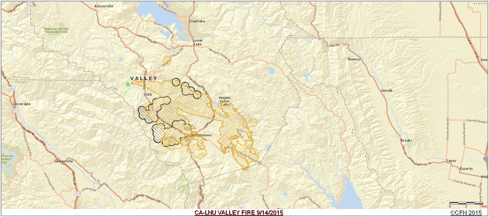
FIRE MAP:
VALLEY FIRE PERIMETER MAP
UPDATES: 
09/14/2015 1700: 62,000 acres, 10% contained.


09/14/2015 0700: 61,000 acres, 5% contained. Barbara McWilliams died in her home.

09/13/2015 1915: 50,000 acres, 0% contained.

09/13/2015 0700: 40,000 acres, 0% contained. Fire is still exhibiting extreme fire behavior. Communities that remain threatened are Middletown, Cobb and Hidden Valley.

09/12/2015 1905: 10,000 acres, 0% contained. Extreme fire behavior. Communities of Cob and Middletown threatened with evacuations in progress. CAL FIRE Team 3 is being mobilized to this incident.

09/12/2015: 250 acres, 0% contained. Fire is burning in grass and brush, northwest of Middletown with a moderate rate of spread. Structures are threatened.

09/12/2015: 200 acres, 0% contained running fire with long range spotting. Community of Cobb threatened, with evacuations in progress.

09/12/2015 1430: 50 acres burning in brush and timber with dangerous rate of spread. 0% contained. Fire is located northwest of Middletown. Structures are threatened.


Video: 
A driver recorded harrowing video of his escape from the Valley Fire as it burned in Lake County's Anderson Springs on Saturday, Sept. 12, 2015. 


CA-YNP TENAYA FIRE Yosemite National park [Map]

Yosemite Fire Update #19, September 12, 2015

Tenaya Fire Map
Tenaya Fire Map
Update: Tenaya Fire  (37 46.091 x 119 34.641 – Mariposa Co., 7200’ El. 8/7). This wildfire began on the afternoon of September 7, 2015, and is being suppressed. The fire is located along the Lehamite Creek Trail from the north rim of the Valley to the Tioga Road. The fire is at 415; the change is due to more accurate mapping by firefighters hiking the perimeter.

The fire continues to creep through surface fuels and the understory of trees. No new spot fires have been found. The firefighter efforts at the heel or anchor point continue to hold as they make good progress along both flanks of the fire. There were no air tanker flights yesterday.

Fire activities include light mop-up to hold and secure the fire line. Firefighters are adhering to Minimum Impact Suppression Techniques (MIST). They are looking for opportunities to tie fire line into granite rock, trails, and other natural barriers with the least impacts to the environment, cultural and historical features. Snags (standing dead trees), which are safety hazards to firefighters by falling, are being preserved when possible. Yosemite Resource Advisors are assigned to the fire to assist firefighters.

There are 162 firefighters committed - resource demobilization will continue over the next few days. Assisting organizations and cooperators include the US Forest Service, Bureau of Land Management, and other National Park Service resources.

Risks include firefighter and visitor safety, and to the Tioga Road. A closure of the road would negatively affect the local communities that rely on park visitation, including the communities of Lee Vining, Mammoth Lakes, Groveland and Mariposa.

There have been 2 minor injuries. There is no threat to structures. There is no estimated full containment and the cause is being investigated.

Yosemite thanks all fire crews, engines, pilots and overhead who responded to the Tenaya Fire.

Tenaya Fire (37 46.091 x 119 34.641 – Mariposa Co., 7200’ El. 8/7). This wildfire began on the afternoon of September 7, 2015, and is being suppressed. The fire is located along the Lehamite Creek Trail from the north rim of the Valley to the Tioga Road. The fire remains at 455 acres with 25% containment.

The Incident Commander noted that firefighters continued to make progress on holding the perimeter line and putting out spot fires. Minimal fire spread is expected and line construction continues on the west flank. Crews have begun direct line construction across the head of the fire. The fire continues to flank across slopes, creep through surface fuels and the understory of trees. Single tree torching was also noted. Existing spot fires were mitigated and no new were found. The firefighter efforts at the heel or anchor point continue to hold as they make good progress along both flanks of the fire. Firefighter actions were able to reduce the need for air tanker operations.

Although fire retardant has been employed in the suppression of the Tenaya Fire, firefighters are adhering to Minimum Impact Suppression Techniques (MIST). They are looking for opportunities to tie fire line into granite rock, trails, and other natural barriers with the least impacts to the environment, cultural and historical features. Snags (standing dead trees) which are safety hazards to firefighters by falling, are being preserved when possible. Yosemite Resource Advisors are assigned to the fire to assist firefighters.

Firefighting resources assigned are adequate for accomplishing the objectives of the fire. Fire managers anticipate significant resource demobilization within the next few days. Assisting organizations and cooperators include the US Forest Service, Bureau of Land Management, and other National Park Service resources. There are 270 personnel committed to the fire.

Risks include firefighter and visitor safety, and to the Tioga Road. A closure of the road would negatively affect the local communities that rely on park visitation, including the communities of Lee Vining, Mammoth Lakes, Groveland and Mariposa.

There has been one minor injury. There is no threat to structures. There is no estimated full containment and the cause is being investigated.

A Safety Closure, issued by the park superintendent, is in place. It will remain in place until rescinded. All trails on the north rim of Yosemite Valley south of the Tioga Road and east of Yosemite Creek are closed. Trail blocks are in place – please adhere to their warnings of exclusion. Currently no roads are closed within the park.  

Other fires being monitored:
Cathedral (37 51.078 x 119 25.120 – Tuolumne Co., 9400’El., 8/2). This is near the John Muir Trail to Cathedral Lakes.  The perimeter is actively smoldering and creeping through lodgepole pine needles and logs and has good potential to grow until it hits natural barriers.  The fire is 37 acres.  

Middle (37 51.538 x 119 41.194 - Tuolumne Co., 8043’El., 7/27). It is west of White Wolf and south of the Middle Tuolumne River.  It is at 71 acres. Yosemite Fire Crew 1 and Saguaro Wildland Fire Module are assigned to this fire.

White Cascade (37 54.926 x 119 23.780 - Tuolumne Co, at 9000’ el., 7/3).  This remote fire is within Tuolumne Meadows and is approximately 30 acres.

All visitors are urged to be diligent in any use of fire, including smoking.  And be sure all fires are out! As with all fires, staff and visitor safety is of paramount importance.  Each fire, regardless of size, is assessed for the appropriate course of action.

Yosemite as other mountain areas continues to experience air quality impacts due to regional fires. Mariposa County Health Department/Air Pollution Control District has issued an Air Quality Alert. This alert extends throughout the entire Central Valley of California. Smoke levels are in the Unhealthy Range. The county suggests remaining indoors or minimizing outdoor activities as much as possible. This condition is expected to continue through the next several days. Visit http://www.mariposa.org/aqi


For additional fire Information

Saturday, September 12, 2015

BUTTE FIRE CA-AEU-Butte Amador & Calaveras Counties [NEW MAPS]

BUTTE FIRE CA-AEU-Butte Wildland Fire Amador & Calaveras Counties 

Butte Fire - Wildland Fire Map
CA-AEU-Butte Wildland Fire Map

Evacuations:
(Mandatory evacuations will stay in place for communities inside the perimeter of the fire with the exception of communities north of the Calaveras River and the Hwy 26 corridor. Repopulation for all areas outside of the perimeter has been completed. Evacuation Advisories will remain in affect for the surrounding area. Road closures in affect in portions of Sheep Ranch Rd, Railroad Ranch Rd, Swiss Ranch Rd and Jesus Maria Rd
UPDATES:
09/18/2015 0745: 70,760 Acres 60 % cont. 6,000 Single Residence homes remain threatened with 12  damaged by fire and 365 destroyed. Damage inspection teams will deploy today and continue the process of collecting information on damaged and destroyed structures. 
Mandatory evacuations will stay in place for communities inside the perimeter of the fire with the exception of communities north of the Calaveras River and the Hwy 26 corridor. Repopulation for all areas outside of the perimeter has been completed. Evacuation Advisories will remain in affect for the surrounding area. Road closures in affect in portions of Sheep Ranch Rd, Railroad Ranch Rd, Swiss Ranch Rd and Jesus Maria Rd
09/17/2015 0745: 70,760 acres, 49% contained. Reduction in acreage due to better mapping intelligence. So far 252 residences confirmed destroyed. Damage inspection teams will deploy again today and continue the process of collecting information on damaged and destroyed structures. DINS reports there will be additional destroyed and damaged structures confirmed as they continue their survey. 


09/16/2015 0745: 71,780 acres - 45% contained
Structures Threatened: 6,400
Structures Destroyed: 233 residences, 175 outbuildings, 15 structures damaged.


09/15/2015 1745: 71,780 acres, 40% contained. 6,000 Homes remained threatened, 233 destroyed. Mandatory evacuations in place for the communities of West Point, Mountain Ranch, Sheep Ranch and Railroad Ranch. Evacuation Advisories remain in affect. Road closures in affect on Hwy 26 from Hwy 49 to the Calaveras County line, portions of Mountain Ranch road, Hwy 49, Tabeau road and East Clinton road. Repopulating in all areas along Hwy 88 in Amador County. 


09/15/2015 0745: 71,660 acres, 37% contained. 166 Homes destroyed.

Mandatory evacuations in place for the communities of West Point, Mountain Ranch, Sheep Ranch and Railroad Ranch. 
09/14/2015 1600: #ButteFire is over the line in Divisions Golf, Kilo and Papa. Winds picking up! #LCES
Acres Burned - Containment: 71,063 acres - 30% contained 
Structures Threatened: 6,400
Structures Destroyed: 135 residences, 79 outbuildings, 4 structures damaged
FIRE CREW INMATE WORKING BUTTE FIRE
CREDIT: SFGate
09/14/2015 1600: Topo Map: 

Butte Fire Topo Map
09/14/2015 1200: 71,063 Acres, CAL FIRE IMT-1, Butte AA requesting 1 VLAT, 2 LAT's and 2 S-2's to the incident. Neptune, Collson 131, and 912 so far) looks like all heading to the Butte.


Critical Resource Needs in 12-, 24-, 48-, and 72-hour timeframes :
12 hours: 23 Type 1 Hand Crew Strike Teams - 21 Hand Crews any type - 23 HEQB - 8 MAST - 10 Type 6 Engines
24 hours: 23 Type 1 Hand Crew Strike Teams - 21 Hand Crews any type - 23 HEQB - 8 MAST - 10 Type 6 Engines
48 hours: 23 Type 1 Hand Crew Strike Teams - 21 Hand Crews any type - 23 HEQB - 8 MAST - 10 Type 6 Engines
72 hours: To be determined based off resource orders being filled and control lines being established and held.
09/13/2015 0600: 65,215 acres with 20% containment.
09/12/2015 1200: Per Calaveras County SO web site, new mandatory evacuations for a portion of San Andreas
09/12/2015 1800: 65,000 acres, 15% 86 homes and 51 outbuildings destroyed. "Hot and dry weather coupled with fuel moisture at critical levels have resulted in extreme fire spread. Resources requested are arriving and being in implemented in the plan. Primary and secondary lines are being constructed and contingency planning continues."

IA Location: Butte Mountain Rd SE of Jackson City Amador County, 

IA Acres: 5
IA ROS: Rapid
IA ROC: Initial fire slowly being contained, spot well established in the Mokelumne drainage is RROS
Structure threats: Yes
Resources: Initial high dispatch + 10 agency engines, 2 Doz, 2AT, 1 Copt, 2 Scoopers
Will be ordering additional shortly

Communications: COMMAND NIFC 33 - 166.325
Online Scanners: http://www.broadcastify.com/listen/feed/20173/webhttp://www.broadcastify.com/listen/ctid/187/web
http://www.broadcastify.com/listen/feed/16015/web


Twitter Buttons

****REMINDER**** Every fire has the ability to be catastrophic. The wildland fire management environment has profoundly changed. Growing numbers of communities, across the nation, are experiencing longer fire seasons; more frequent, bigger, and more severe, fires are a real threat. Be careful with all campfires and equipment.

"I am a firm believer in the people. If given the truth, they can be depended upon to meet any national crisis. The great point is to bring them the real facts, and beer." --Abraham Lincoln

View blog top tags
---------------------
CLICK HERE TO GO BACK TO TOP OF CALIFORNIA FIRE NEWS HOME PAGE

Subscribe via email to California Fire News - Keep track of Cal Fire News

Enter your email address:

Delivered by FeedBurner