Lowell Fire - CA-NEU Lowell Fire - Gold Run, Placer County
All evacuation advisories have been lifted
Updates:
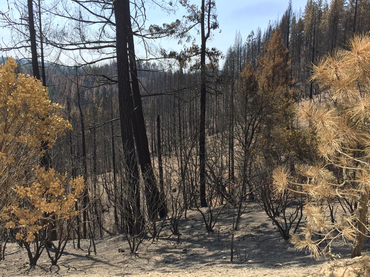
08/09/2015 0800: 2304 Acres 92%, No new damage to structures occurred this reporting period.
08/05/2015 0800: 2,304 Acres 88%, All evacuation advisories have been lifted, some road closures still in place.
08/03/2015 0800: 2,304 acres, 85% contained. Transition to local unit planned for today.
08/02/2015 0800: 2,304 acres, 80% contained. Fire suppression repair continues.
08/01/2015 0800: 2,303 acres, 75% contained. Smoldering fire behavior with backing fire in small interior islands. Fire suppression repair continues.
07/31/2015 1930: 2,303 acres, 75% contained.
07/31/2015 0700: 2,303 acres, 75% contained. The fire continues to smolder and back into small interior islands.
Updates:
08/09/2015 0800: 2304 Acres 92%, No new damage to structures occurred this reporting period.
 |
| Lowell Fire 8-9-15 Credit: Grace Lidia Suarez @gracels |
08/05/2015 0800: 2,304 Acres 88%, All evacuation advisories have been lifted, some road closures still in place.
08/03/2015 0800: 2,304 acres, 85% contained. Transition to local unit planned for today.
08/02/2015 0800: 2,304 acres, 80% contained. Fire suppression repair continues.
08/01/2015 0800: 2,303 acres, 75% contained. Smoldering fire behavior with backing fire in small interior islands. Fire suppression repair continues.
07/31/2015 1930: 2,303 acres, 75% contained.
07/31/2015 0700: 2,303 acres, 75% contained. The fire continues to smolder and back into small interior islands.
 |
| Lowell Fire Hotspot Map |
 |
Lowell Fire - CA-NEU Lowell Fire- Gold Run, Placer CountyCredit: @CapRadioNews |
 |
| Lowell Fire Hot Spot Map |
Update 7-29-15 1100: 2,303 acres, 45% contained. Fire behavior was moderate with poor overnight humidity recovery. Evacuation warnings and advisories remain in effect.
Update 7-28-15 1830: 2,302 acres, 40% contained. Slope and wind-driven runs occurred today along with torching and short range spotting.
Update 7-28-15 0900: 2,233 acres, 30% contained. The fire was active through the night with multiple uphill runs, group torching and short crown runs. Poor humidity recovery, moderate winds contributed to increased fire behavior overnight.
Update 7-27-15 1900: 1,521 Acres, heavy brush and timber, 5% Contained
South Central Sierra Interagency IMT (Cooper) is in command.
Evacuations remain unchanged.
Madera County Road 274 was reopened today at 1200.
Update 7-27-15 0900: 1,700 acres, 20% contained. Fire continued to burn actively through the night There was torching and short range crown runs creating short range spotting.
Update 7-26-15 1900: 1,500 acres, 15% contained. Increased afternoon fire activity with terrain driven runs.
Update 7-26-15 0900: 1,500 acres, 0% contained. Expected increased fire behavior as inversions lifts. Structures remain threatened with evacuation orders in place. CAL FIRE IMT1 (Gouvea) assumes command today.
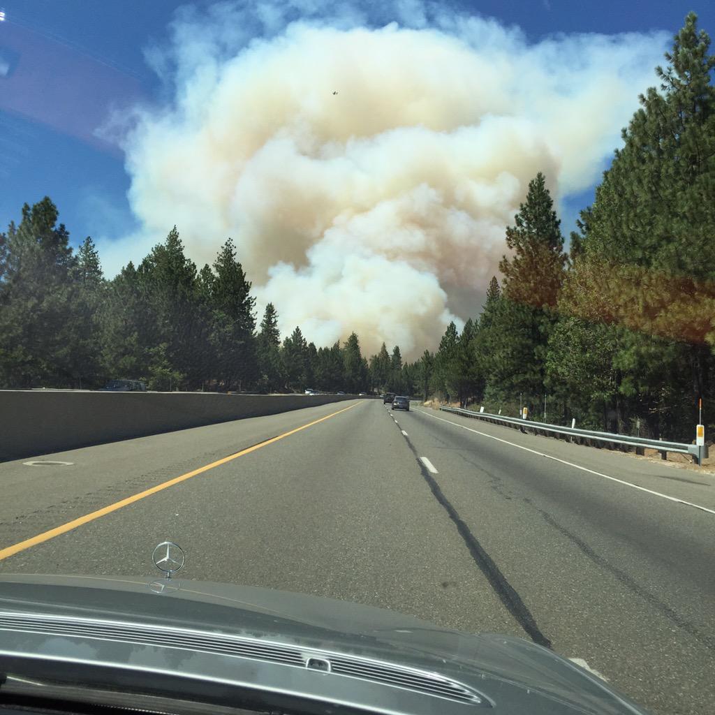
Update 7-25-15 1900: 4,000 acres, burning along Steep Hollow Creek Terrain. Helibase at Blue Canyon Airport being opened. Now 600 firefighters including 55 engines, 9 airtankers, 9 copters & 13 crews on the lines.
Per Cal Fire PIO Daniel Berlant: Investigators are asking the public’s help in looking for a vehicle of interest that was in the area when the fire started. The vehicle is a lifted 4x4 white jeep wrangler without a top, a black roll bar and no front doors that was in the Gold Run/Dutch Flat area around 2:30pm. Anyone with information should contact the Placer or Nevada County Sheriff’s Department.
Update 7-25-15 1830: 3,000 acres, 0% contained. Crown fire with long range spotting. Structure threat continues with evacuations.
Update 7-25-15 1700: 3000 acres. Type 1 Team pending in ROSS. VLAT 911 now enroute to the Fire from WA State
Update 7-25-15 1700: 1500 acres, numerous areas of structure threats. Still spotting. Big resource orders including 8 Gulf ST's, 10 Charlie ST's, 4 DIVS requested. East side of Cascade Shores is being evacuated, along with areas east. Lowell Hill Rd closed at SR-20. Quaker-Hill closed at Pasquale Rd
Update 7-25-15 1615: PCSO advises heavy spot fires in Cascade Shores area. Stating needs to evacuate area.
.@CalFireNews Lowell Fire, seen from my house pic.twitter.com/VzMY7woEZq
— Grace Lidia Suarez (@gracels) July 25, 2015
 |
| Lowell Fire Credit: Nicole Novak @matsutake2 |
Update 7-25-15 1600: 450 acres, Rapid rate of spread, Evacuations, Potential large incident. 2 type 1 copters, 2 type 2 copters, 1 additional VLAT. Grass Valley AAB out of power, can't pump retardant.
Update 7-25-15 1515: 100 acres, 0% contained burning in timber. Fire is located 2 miles northwest of Gold Run. Rapid rates of spread. Powerlines are threatened.
Location: Gold Run, CA - Lowell Hill Road and Chicago Park Powerhouse Road, Alta (Placer County)
Acres: 20-35
ROS: Rapid
ROC: 20-35 acres.
Fuel Model: Heavy Timber (Grass and Understory)
Structure threats: not currently threatened
Special Hazards: High voltage power lines.
Resources: Air Attack just requested VLAT, in addition to 3 S-2s and the DC-7 from Chico.
Online Scanner: http://www.broadcastify.com/listen/feed/9035/web/?rl=rr
Live Video:
Web Cam: http://www.webcamgalore.com/EN/webca...nia/14548.html
Tweet
No comments:
Post a Comment
CAL FIRE NEWS LOVES COMMENTS...
- Due to rampant abuse, we are no longer posting anonymous comments. Please use your real OpenID, Google, Yahoo, AIM, Twitter, Flickr name.