Date of Origin: Wednesday April 30th, 2014 approx. 08:00 AM
Cause: Under Investigation
Location: Etiwanda Preserve north of Rancho Cucamonga
Incident Commander: Kempter Note: Type II Incident Management So Cal Team 1 is in command of the fire as of 0600 on 05/01/14.
Current Situation: Size 1,000 acres
Fuels: Brush
Fire Behavior: Wind driven fire, rapid rate of spread, extreme fire behavior structure defense in place
Terrain Difficulty: Rugged

Incident commanders met with local forest representative and agreed on a transition of command back to San Bernardino national forest tentatively at 0600 on 5/4/2014.
Update 5-2-14 1745: 2,190 acres, 67% contained. Midslope fireline continues to be wind tested as wind direction has changed. The trend toward cooler temperatures will moderate fire activity.
Update 5-2-14 0900:The perimeter of the Etiwanda fire held successfully overnight. A small flare up did occur in the area of Smith drainage but was quickly put out. Firefighters were able to make good progress on constructing line around the burn. The estimated size of the fire has increased to 2190 acres due to better mapping, with containment remaining at 53%. Structure protection engines will continue to patrol the neighborhoods near the fire perimeter.
Engines: 62
Crews: 20
Dozers: 3
Water Tenders: 16
Helicopters: 4
Fixed Wing: 2 air tankers
Injuries: 2
Total Personnel: 929
Structures Destroyed: 0
Structures Damaged: 1
Road Closures : The opening of some roads began at 7:00 p.m. last night and will continue today.
Injuries: 3 firefighters recieved minor injuries
Cause: Under Investigation
Cooperating Agencies: CAL FIRE, US Forest Service and Rancho Cucamonga Fire
Total Fire Personnel: 892
Total Fire Engines: 52
Total Fire crews: 20
Total Dozers: 3
Total Water Tenders: 16
Incident Management Team: Unified Command USFS/CAL FIRE/Rancho Cucamonga Fire Department.Update 5-2-14 0800: 2,190 acres and 67% contained
Update 5-2-14 0800: 1,627 acres, 53% contained. Minor interior flareups overnight with diminishing winds. All schools have reopened today. Threat to endangered species habitat and watershed has diminished, however potential still remains

Evacuations: Mandatory evacuation order has been Lifted
April 30, 2014 3:33 p.m. – Update Etiwanda Fire
North of Wilson between Day Creek and Etiwanda
All residents East of Haven to Carnelian, North of Hillside.
For updates on the fire and evacuations call (909)383-5688.
Evacuation Center Central Park on Baseline/Milliken in Rancho Cucamonga
Mandatory evacuation order has been issued for residents from east of Day Creek wash, west of Etiwanda Avenue, north of Wilson Avenue, officials said.Day Creek Intermediate School, Caryn Elementary and Los Osos High School have been evacuated.
Students from Day Creek Intermediate are being taken to Heritage Immediate School at 13766 South Heritage Circle in Fontana and Caryn Elementary students are being transported to Perdew Elementary School at 13051 Miller Avenue in Etiwanda.
Los Osos High School students without transportation will be bused to Rancho Cucamonga High School at 11801 Lark Drive.
Road Closures: Only residents allowed in
Etiwanda Ave between Banyan St. and the Northern City Limit
Day Creek Blvd. between Banyan St and the Northern City Limit
Milliken Ave between Wilson Ave and Northern City Limit
Hillside Rd between Haven Ave and the Western CIty Limit
Banyan St between Milliken Ave and Day Creek Blvd
Media Center at Indian Wells and Melon Ct. Contact Bob Poole
Update 5-1 1930: 1,627 acres, 53% contained. FRA. Unified Command; USFS, Cal Fire, Rancho Cucamonga RD, Rancho Cucamonga PD. Strong Santa Ana winds continue to effect the incident. A Red Flag warning and high wind warning are in effect throughout this evening.
Update 5-1 0930: Last night, fireline around the Etiwanda fire held successfully. The fire did not move beyond the perimeter from yesterday, despite high winds occurring early this morning. Until aircraft are able to fly and map the fire area, the fire size remains at 1,000 acres with 10% containment this morning. Firefighters are working on strengthening existing fire lines in Rancho Cucamonga and constructing new lines and extending hose lines in the foothill areas of Deer and Day Creek Canyons. Structure protection engines continue to patrol the neighborhoods near the fire perimeter.
Update 5-1 0830: 1000 acres 10% contained. Type II Incident Management So Cal Team 1 is in command of the fire as of 0600 on 05/01/14.
Red Flag Warning with forecsted winds of 40 to 60 mph. Extremely low relative humidity with little or no recovery through Thursday
Update 2230: 1,000 acres, all mandatory evacuations lifted. Fire is being pushed south by winds gusting to 60 mph.
Update 1830: #EtiwandaFire 1,000 acres, 0% contained. FRA, Unified Command; USFS, Cal Fire, Rancho Cucamonga FD, Rancho Cucamonga PD, The fire is north of Rancho Cucamonga in the Etiwanda Falls area. Extreme fire behavior with rapid rate of spread. Evacuations in effect for the north end of Rancho Cucamonga. 5 schools and 1,100 residents are evacuated. There is a Red Flag Warning in place with winds to 60 to 90 mph expected.
Update 1530: #EtiwandaFire is now over 1000 acres, About 550 firefighters on scene. Temps around 90, RH 3% - 9%. typical Santa Ana-type outflow winds are coming out of the mountains.
Update 1330: Officially now 800 acres 1,650 homes evacuated.
Update 1240: #EtiwandaFire Officially now 650 acres
Update 1110: - 1 sizeup report of approximately 700 acres. Bulldozers have now been approved for use in the Etiwanda preserve. winds sustained 20, gusts over 50. Fuels only 2 foot tall near the interface and with winds flattening the flames, flame lengths at the interface are low. Small spots in ornamental veg. around structures
Update 1030: - 200 acres RROS, burning South. 550 personel, 30 engines, 18 crews
Update 5-7-14 0900: Fire has burned 2,190 acres, with 98% containment.
This incident has transitioned to a Type 4 IC.
Update 5-6-14 0945: Fire has burned 2,190 acres, with 96% containment.
Update 5-5-14 1545: 2,190 acres, with 94% containment.
Type 3 organization has taken over the fire
Update 5-5-14 0745: Etiwanda fire is 94% contained this morning. Most of the fire is now confined to heat patches in the mountain foothills. The San Bernardino National Forest and Cal Fire are working on the remaining heat patches and mopping up. Crews are also restoring areas affected by dozer lines. The fire size of 2190 acres is expected to be the final size.
Update 5-3-14 1745: Fire has burned 2,190 acres, with 67% containment
Incident remains in Unified Command;
(USFS, Cal Fire, Rancho Cucamonga FD,
Rancho Cucamonga PD)
SOCAL T/2 IMT (Walker Team 1) remains assigned.
Update 5-3-14 0745: Fire is holding at 2,190 acres, with 67% containmentNo significant fire behavior observed. Fire consists of smoldering remnants that require mop-up. Hot material near fire line still poses a threat.Incident commanders met with local forest representative and agreed on a transition of command back to San Bernardino national forest tentatively at 0600 on 5/4/2014.
Update 5-2-14 0900:The perimeter of the Etiwanda fire held successfully overnight. A small flare up did occur in the area of Smith drainage but was quickly put out. Firefighters were able to make good progress on constructing line around the burn. The estimated size of the fire has increased to 2190 acres due to better mapping, with containment remaining at 53%. Structure protection engines will continue to patrol the neighborhoods near the fire perimeter.
Engines: 62
Crews: 20
Dozers: 3
Water Tenders: 16
Helicopters: 4
Fixed Wing: 2 air tankers
Injuries: 2
Total Personnel: 929
Structures Destroyed: 0
Structures Damaged: 1
Road Closures : The opening of some roads began at 7:00 p.m. last night and will continue today.
Injuries: 3 firefighters recieved minor injuries
Cause: Under Investigation
Cooperating Agencies: CAL FIRE, US Forest Service and Rancho Cucamonga Fire
Total Fire Personnel: 892
Total Fire Engines: 52
Total Fire crews: 20
Total Dozers: 3
Total Water Tenders: 16
Incident Management Team: Unified Command USFS/CAL FIRE/Rancho Cucamonga Fire Department.Update 5-2-14 0800: 2,190 acres and 67% contained
Update 5-2-14 0800: 1,627 acres, 53% contained. Minor interior flareups overnight with diminishing winds. All schools have reopened today. Threat to endangered species habitat and watershed has diminished, however potential still remains
 |
| Etiwanda Fire Hot-spot and Perimeter Map 5-1-14 |
 |
| #EtiwandaFire: Thermal MODIS Street Map 1 Fire Perimeters |
 |
| #EtiwandaFire: Thermal MODIS Satellite Map Fire Perimeters 2014-04-30 |
 |
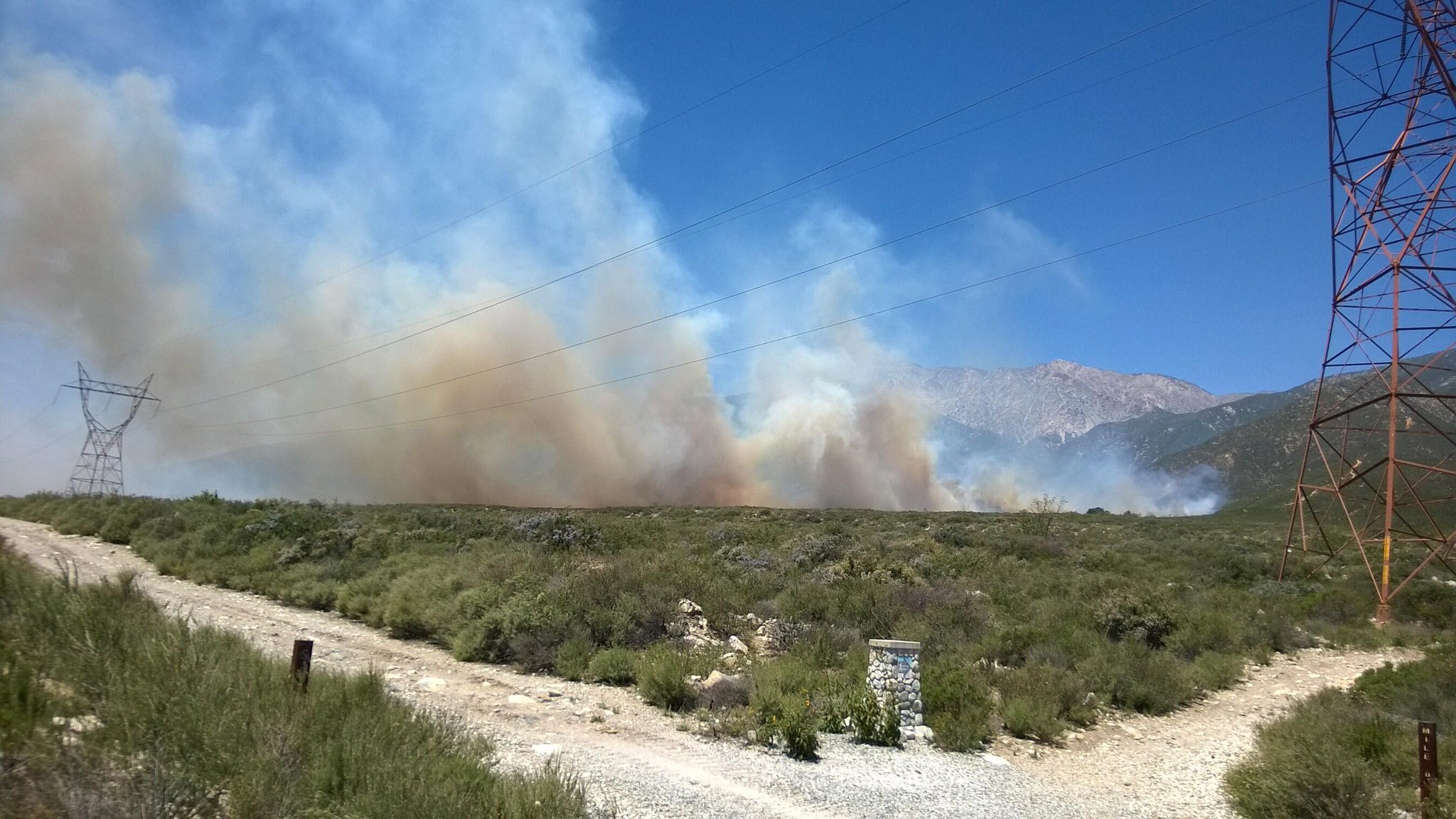
Smoke from 800-acre #EtiwandaFire blowing in strong winds
Source: @KTLA
|
 |
| Etiwanda Wildfire San Bernardino County https://pbs.twimg.com/media/BmfmwtSCAAALTj7.jpg:large |
April 30, 2014 3:33 p.m. – Update Etiwanda Fire
Mandatory evacuations have been established for the areas of:
All homes north of Banyan – between Rochester and Etiwanda
North of Wilson from Etiwanda Ave. and west to the wash.
Etiwanda Ave. to Day Creek, north of Wilson
Voluntary Evacuations:
North of Hillside from Haven, East to Milliken All homes north of Banyan – between Rochester and Etiwanda
North of Wilson from Etiwanda Ave. and west to the wash.
Etiwanda Ave. to Day Creek, north of Wilson
Voluntary Evacuations:
North of the 210 freeway between Milliken and Etiwanda
For updates on the fire and evacuations call (909)383-5688.
Evacuation Center Central Park on Baseline/Milliken in Rancho Cucamonga
Mandatory evacuation order has been issued for residents from east of Day Creek wash, west of Etiwanda Avenue, north of Wilson Avenue, officials said.Day Creek Intermediate School, Caryn Elementary and Los Osos High School have been evacuated.
Students from Day Creek Intermediate are being taken to Heritage Immediate School at 13766 South Heritage Circle in Fontana and Caryn Elementary students are being transported to Perdew Elementary School at 13051 Miller Avenue in Etiwanda.
Los Osos High School students without transportation will be bused to Rancho Cucamonga High School at 11801 Lark Drive.
Road Closures: Only residents allowed in
Etiwanda Ave between Banyan St. and the Northern City Limit
Day Creek Blvd. between Banyan St and the Northern City Limit
Milliken Ave between Wilson Ave and Northern City Limit
Hillside Rd between Haven Ave and the Western CIty Limit
Banyan St between Milliken Ave and Day Creek Blvd
Media Center at Indian Wells and Melon Ct. Contact Bob Poole
Update 5-1 1930: 1,627 acres, 53% contained. FRA. Unified Command; USFS, Cal Fire, Rancho Cucamonga RD, Rancho Cucamonga PD. Strong Santa Ana winds continue to effect the incident. A Red Flag warning and high wind warning are in effect throughout this evening.
Update 5-1 0930: Last night, fireline around the Etiwanda fire held successfully. The fire did not move beyond the perimeter from yesterday, despite high winds occurring early this morning. Until aircraft are able to fly and map the fire area, the fire size remains at 1,000 acres with 10% containment this morning. Firefighters are working on strengthening existing fire lines in Rancho Cucamonga and constructing new lines and extending hose lines in the foothill areas of Deer and Day Creek Canyons. Structure protection engines continue to patrol the neighborhoods near the fire perimeter.
Update 5-1 0830: 1000 acres 10% contained. Type II Incident Management So Cal Team 1 is in command of the fire as of 0600 on 05/01/14.
Red Flag Warning with forecsted winds of 40 to 60 mph. Extremely low relative humidity with little or no recovery through Thursday
Update 2230: 1,000 acres, all mandatory evacuations lifted. Fire is being pushed south by winds gusting to 60 mph.
| Wildfire | |
Current Situation
| Total Personnel | 706 |
|---|---|
| Size | 1,000 acres |
| Fuels Involved |
brush
|
| Fire Behavior |
wind driven fire, rapid rate of spread, extreme fire behavior
|
Outlook
| Planned Actions |
structure defense in place
|
|---|---|
| Terrain Difficulty |
rugged
|
| Remarks |
55 engines, 19 crews, 4 dozers,
|
Update 1530: #EtiwandaFire is now over 1000 acres, About 550 firefighters on scene. Temps around 90, RH 3% - 9%. typical Santa Ana-type outflow winds are coming out of the mountains.
Update 1330: Officially now 800 acres 1,650 homes evacuated.
| Administrative Unit: | CAL FIRE San Bernardino / USFS / Rancho Cucamonga Fire | |
| County: | San Bernardino County | |
| Location: | North of Rancho Cucamonga | |
| Acres Burned - Containment: | 800 acres | |
| Structures Threatened: | Structures remain threatened | |
| Evacuations: | Mandatory evacuations have been established for the area of: All areas north of Wilson from Etiwanda Ave. and west to the wash.
Voluntary evacuation areas: All residents East of Haven to Carnelian, North of Hillside.
A temporary evacuation center has been at Central Park, Northwest corner of Milliken/Baseline, for residents within the mandatory evacuation area.
Chaffey College classes have been cancelled for the day.
Etiwanda School District voluntarily moved students from Colony Elementary to Terra Vista Elementary.
More info on Evacuations can be found on the San Bernardino County Sheriff's website.
| |
| Cooperating Agencies: | CAL FIRE, US Forest Service and Rancho Cucamonga Fire | |
| Total Fire Personnel: | 550 | |
| Total Fire Engines: | 30 | |
| Total Fire crews: | 18 | |
| Incident Management Team: | Unified Command USFS/CAL FIRE/Rancho Cucamonga Fire Department | |
| Lat/Long: | -117.55292/34.167091 | |
| Conditions: | The fire is being pushed south by gusty winds of up to 60 mph. | |
Update 1110: - 1 sizeup report of approximately 700 acres. Bulldozers have now been approved for use in the Etiwanda preserve. winds sustained 20, gusts over 50. Fuels only 2 foot tall near the interface and with winds flattening the flames, flame lengths at the interface are low. Small spots in ornamental veg. around structures
Update 1030: - 200 acres RROS, burning South. 550 personel, 30 engines, 18 crews
IA: Wildland Fire started around 8:00 am on Wednesday April 30 in Day Canyon above Rancho Cucamonga.
Location: North of Rancho Cucamonga San Bernardino National Forest / Day Canyon. East Ave x Powerline Rd, Etiwanda, San Bernardino County,
Staging 6001 Millerton Ave.
GPS: 34.175 latitude, -117.542 longitude
Location: North of Rancho Cucamonga San Bernardino National Forest / Day Canyon. East Ave x Powerline Rd, Etiwanda, San Bernardino County,
Staging 6001 Millerton Ave.
GPS: 34.175 latitude, -117.542 longitude
CDF - 34.169346 latitude, -117.547374 longitude
Maps: http://bit.ly/1jijie7
Wind Forecast: http://tmappsevents.esri.com/website/wildfire_time/
Frequencies: 171.475, 168.200. Tac: NIFC TAC 2,4,6
Online Scanner: http://www.broadcastify.com/listen/feed/15126/web
Live Video:http://abclocal.go.com/kabc/live
Weather: -
Web Cams: -
---------------------------------------------
Frequencies: 171.475, 168.200. Tac: NIFC TAC 2,4,6
Online Scanner: http://www.broadcastify.com/listen/feed/15126/web
Live Video:http://abclocal.go.com/kabc/live
Weather: -
Web Cams: -
---------------------------------------------
No comments:
Post a Comment
CAL FIRE NEWS LOVES COMMENTS...
- Due to rampant abuse, we are no longer posting anonymous comments. Please use your real OpenID, Google, Yahoo, AIM, Twitter, Flickr name.