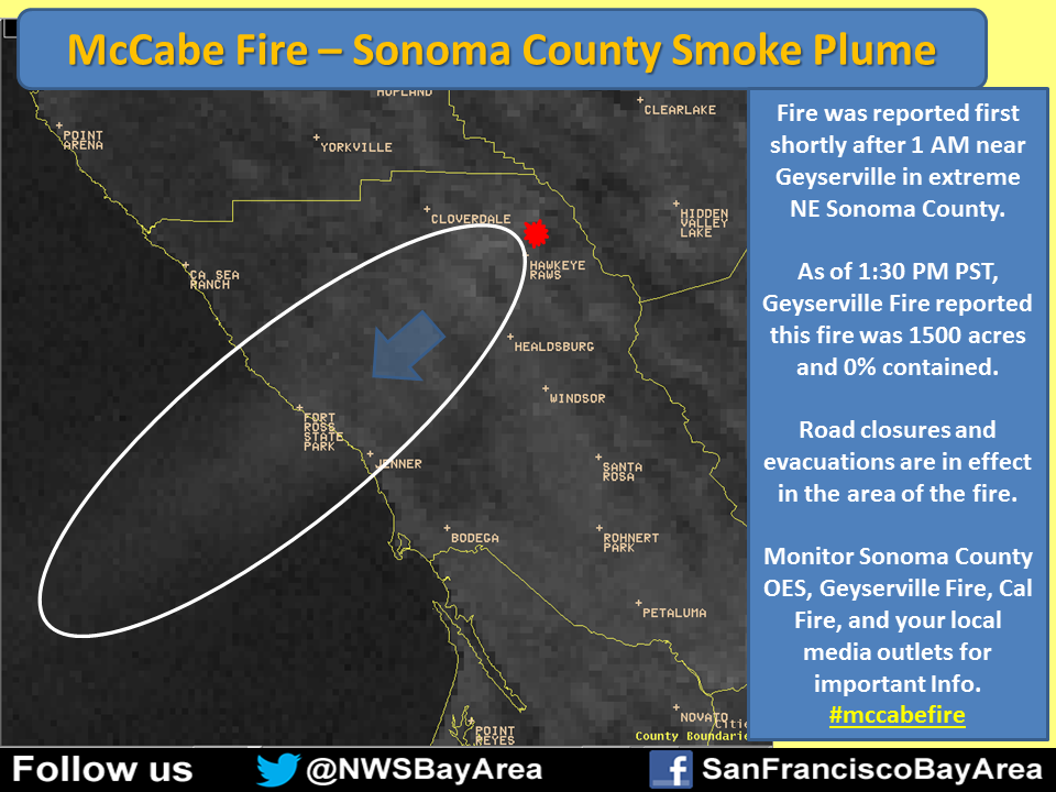
McCabe Fire - CA-LNU McCabe Fire - Geysers Geo-Thermal Plant Sonoma County
Evacuations in progress
Onscene Video 1:
Onscene Video 2:
Update 11/27 2000: 3505 acres, 100% contained.
Update 11/27 1730: 3505 acres, 95% contained.
Update 11/26 0730: 3505 acres, 90% cont.
Update 11/25 0730: 3,505 acres, 75% contained. Expected containment 11/27/13. Acreage adjusted due to more accurate mapping. Isolated fire activity within the containment lines.
Update 11/24 1730: 3,300 acres, 65% The incident had isolated fire activity within the containment lines. Significant demobilization of resources is planned for 11/25-26.
Update 11/24 0730: 3,300 acres, 35% contained. Spotting issues due to severely dry fuels and record high ERC. A slow rate of production in control line is due to high winds and difficult terrain.
Update 11/23 1730: 3000 acres, 25% contained. CAL FIRE Team 3 Michael. Moderate fire spread expected as winds transition to on shore. A threat remains to geothermal electrical generation facility and multiple permanent residences.
Update 11/23 1130: 3500 acres, 0%,CAL FIRE IMT 3
Update 11/23 0730: 2500 acres, 0% contained. Fire has three heads with erratic fire behavior and long range spotting. Evacuations in progress. One geothermal Power Generating Facility destroyed.
Update 11/22 1730: - 2500 acres, 10% contained. Expected containment 12/01/2013. Michael, CAL FIRE IMT 3 has been activated for this fire and will transition with Turbeville, ICT3. Continued threat to the Geyser Geothermal Facility.
Update 11/22 1600: - 2,000 acres, 0% contained. Expected containment 12/01/2013. Turbeville, ICT3. Long range spotting and erratic fire behavior. Threat to Geyser Geothermal Facility. Tomorrow Order for 20 Golfs, 10 Charlies, 7 Limas, 3 Branchs, 9 Divs, and overhead.
Update 11/22 1100: - 200 acres, 10% contained
Update 11/22 0800: - 100 acres, 10% contained.
Location: - Turbeville, Located 10 miles northeast of Geyserville. Geysers Geo-Thermal Plant (Sonoma County) east of Cloverdale
IA Description: - Grass Fire
ROS: Moderate to rapid rate of spread.
ROC: - Located in steep terrain near power plants five and six. Damage from the windstorm also made access difficult, with a fallen tree blocking one of the access roads from the Lake County side and power lines reported to be down.
Special Hazards: Power lines down, geo-thermal activity in the area.
Structure Threats: - Threat to Geyser Geothermal Facility.
Situation Concerns/Alerts: - Power lines down
Additional Resource Notes: - Numerous resources from Lake and Sonoma counties.
Online Scanners: - http://www.broadcastify.com/listen/feed/14279/web
---------------------------------------------
Evacuations in progress
 |
| McCabe Fire Perimeter and Hot Spot Map 3500+ acres, 25% |
 |
| McCabe Fire Perimeter and Hot Spot Map 3500+ acres, 25% |
 |
| McCabe Fire Perimeter and Hot Spot Map 2000+ acres, 0% |
Onscene Video 1:
Onscene Video 2:
Update 11/27 2000: 3505 acres, 100% contained.
Update 11/27 1730: 3505 acres, 95% contained.
Update 11/26 0730: 3505 acres, 90% cont.
Update 11/25 0730: 3,505 acres, 75% contained. Expected containment 11/27/13. Acreage adjusted due to more accurate mapping. Isolated fire activity within the containment lines.
Update 11/24 1730: 3,300 acres, 65% The incident had isolated fire activity within the containment lines. Significant demobilization of resources is planned for 11/25-26.
Update 11/24 0730: 3,300 acres, 35% contained. Spotting issues due to severely dry fuels and record high ERC. A slow rate of production in control line is due to high winds and difficult terrain.
Update 11/23 1730: 3000 acres, 25% contained. CAL FIRE Team 3 Michael. Moderate fire spread expected as winds transition to on shore. A threat remains to geothermal electrical generation facility and multiple permanent residences.
Update 11/23 1130: 3500 acres, 0%,CAL FIRE IMT 3
Update 11/23 0730: 2500 acres, 0% contained. Fire has three heads with erratic fire behavior and long range spotting. Evacuations in progress. One geothermal Power Generating Facility destroyed.
Update 11/22 1730: - 2500 acres, 10% contained. Expected containment 12/01/2013. Michael, CAL FIRE IMT 3 has been activated for this fire and will transition with Turbeville, ICT3. Continued threat to the Geyser Geothermal Facility.
Update 11/22 1600: - 2,000 acres, 0% contained. Expected containment 12/01/2013. Turbeville, ICT3. Long range spotting and erratic fire behavior. Threat to Geyser Geothermal Facility. Tomorrow Order for 20 Golfs, 10 Charlies, 7 Limas, 3 Branchs, 9 Divs, and overhead.
Update 11/22 1100: - 200 acres, 10% contained
Update 11/22 0800: - 100 acres, 10% contained.
Location: - Turbeville, Located 10 miles northeast of Geyserville. Geysers Geo-Thermal Plant (Sonoma County) east of Cloverdale
IA Description: - Grass Fire
ROS: Moderate to rapid rate of spread.
ROC: - Located in steep terrain near power plants five and six. Damage from the windstorm also made access difficult, with a fallen tree blocking one of the access roads from the Lake County side and power lines reported to be down.
Special Hazards: Power lines down, geo-thermal activity in the area.
Structure Threats: - Threat to Geyser Geothermal Facility.
Situation Concerns/Alerts: - Power lines down
Additional Resource Notes: - Numerous resources from Lake and Sonoma counties.
Online Scanners: - http://www.broadcastify.com/listen/feed/14279/web
---------------------------------------------


No comments:
Post a Comment
CAL FIRE NEWS LOVES COMMENTS...
- Due to rampant abuse, we are no longer posting anonymous comments. Please use your real OpenID, Google, Yahoo, AIM, Twitter, Flickr name.