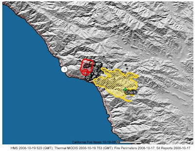
CHALK FIRE UPDATE: Sunday, October 19, 2008, 8:00 PM
Fire Statistics:
Acres burned: 14,666
Percent contained: 79%
Miles of fireline to build: 7.5
Expected containment: 11/01/2008
Firefighter injuries to date: 17
Structures threatened: 49
Structures destroyed: 0
Suppression cost to date: $18.2M
Firefighting Resources:
Crews: 8
Engines: 25
Helicopters: 11
Air tankers: 10
Dozers: 4
Water Tenders: 10
Total personnel assigned: 601
Basic Information
Incident Type Wildland Fire
Cause Under Investigation
Date of Origin Saturday September 27th, 2008 aprox 07:30 PM
Location 22 mi southwest of King City, CA
Incident Commander Dana D'andrea
Fuels Involved
4 Chaparral (6 Feet) Large volume of dead and down material in fire fuel bed. Oak woodland and pockets of timber.
Fire Behavior
Moderate burning within the interior and along the Div A/Z break (Cone Peak to Twin Peaks).
Significant Events
Firing Operation along dozer line south to Hermitage was started at 1200 hours. Smoke and Coastal inversion caused last nights shift to spike out today at Sand Dollar Campground.
Outlook/Planed Actions
Complete firing operation and hold dozer line from safety zone south to the Hermitage. Protect structures north of Lime Kiln and the Hermitage. Monitor fire movement to the north of Cone Peak in order to protect line from Cone Peak to Twin Peak.
Growth Potential Medium
Terrain Difficulty Extreme
Remarks Percentage of Containment changed due to increased acreage from firing operation in Div Z.
Current Status: The firing operation which started about noon today was successful. Crews started from the dozer line approximately 2 miles north of the New Camaldoli Hermitage and burned south along the dozer line. As of this afternoon the firing had almost reached the Hermitage. Crews will continue with the firing operation into this evening as long as there is still opportunity to burn. Crews supported by helicopters and air tankers worked to hold the ridge NW of Twin Peak parallel with the Carizzo Trail. In the Limekiln State Park area, the fire is backing down slowly.
Tonight crews will continue to hold and support the firing operations. Structure protection continues in Limeklin State Park and the Hermitage. Cool temperatures and good relative humidity with light winds should result in minimal perimeter growth. Along the coast, below 1,500 ft. the marine layer will continue to be temperatures cool and moist throughout the night. Firefighter and public safety continue to be the highest priority.
Evacuations: On Friday, October 17, The Monterey County Sheriff's Department issued an EVACUATION WARNING for Limekiln State Park north to the New Camaldoli Hermitage. Approximately 9 residents are within the evacuation area. This stage of Evacuation Warning is given for affected areas where there is imminent threat to life and property. Persons who receive notification of this warning should evacuate in accordance with the direction given to them by Sheriff's Department Deputies who are on scene.
An EVACUATION WATCH was also issued by the Monterey County Sheriff's Department for Lucia north to Lopez Point. This stage of Evacuation Watch is for areas where a threat to life and property exists. Persons who receive notification of this watch are not required to evacuate but should be prepared to evacuate should an Evacuation Warning be issued. Significant resources (hand crews, engines and dozers) are engaged in structure protection.
Highway, Road and Area Closures: Highway-1 is open. Nacimiento-Fergusson Road remains closed, as well as South Coast Ridge Road, south to Willow Creek Road.
Agencies: The incident is currently being managed by a U.S. Forest Service, Type-2, Incident Command Team. Incident Commander Dana D'Andrea (USFS) of Central Coast Interagency Incident Management Team 7, assumed command of the incident at 6:00am yesterday, Saturday, October 18.
Fire Information: Goleta - 805-961-5770 (8am-8pm)
Monterey Ranger District, Los Padres National Forest

No comments:
Post a Comment
CAL FIRE NEWS LOVES COMMENTS...
- Due to rampant abuse, we are no longer posting anonymous comments. Please use your real OpenID, Google, Yahoo, AIM, Twitter, Flickr name.