(CA-LPF-2754) is 5% contained after burning 1,708 acres. People are advised to evacuate the Dempsey Flat area and the Beiar Property. There is a large volume of dead and down material in the fire fuel bed of Oak woodland and pockets of timber. There is no prior recorded fire history in this area.
Chalk Fire Update: 08-29-08 - 19:00 hrs - South Ops OSCC News and Notes:
(CA-LPF-2754) has burned 1,708 acres and is 5% contained. There is potential for fire spread in all directions with frequent spotting up to a 1/8 mile. Access to the fire is a concern with steep rugged terrain. The fire is burning in the Ventana Wilderness and evacuation orders are in place. Rollout significantly contributes to downhill spread.
(CA-LPF-2754), The fire continued to be very active last night with spotting and intense uphill runs on the northeast side.
Crews worked through the night constructing control lines. The fire has a high potential to move extremely quickly and erratically and the terrain is very steep.
Today crews will continue to construct hand line to keep the fire north of Prewitt Ridge, west of Del Venturi Road, south of the San Vicente Trail to San Antonio Trail and east of Highway 1. Crews will be supported by helicopters and air tankers.
Evacuations: Update: 08-30-08 - 08:30 hrs - People are advised to evacuate the Dempsey Flat area and the Beiar Property.
The Monterey County Sheriff issued Mandatory Evacuation Order for the immediate fire area south of Chalk Peak and South Coast Ridge Road. Approximately 7 homes, 1 commercial property and 4 outbuildings are within the evacuation area. An Evacuation Advisory is in place for the Lucia, Mill Creek, Hare Creek and Limeklin State Park. The advisory warns residents to be prepared to evacuate should an order be issued.
Highway, Road and Area Closures: Nacimiento-Fergusson Road and South Coast Ridge Road are closed. Highway 1 is open.
Editors thoughts: Looks to be going big...All the way out to highway 1?
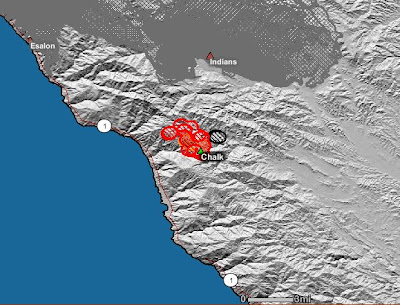
 Chalk Fire perimeter topographic map
Credit: California Fire news / Inciweb

Los Padres National Forest Wildland Fire
Credit: California Fire news / Inciweb
 Chalk Fire perimeter satellite map
Credit: California Fire news / Geomac
HMS 2008-09-28 454 (GMT); Thermal MODIS 2008-09-29 550 (GMT); Fire Perimeters 2008-09-26; Sit Reports 2008-09-28
Basic Information
Incident Type Wildland Fire
Cause: Under Investigation
Date of Origin: Saturday September 27th, 2008 aprox 07:30 PM
Location: Los padres National forest - 22 miles west of King City / 2 miles east of Highway 1, Monterey Road both sides of Coast Ridge Trail south of Nacimiento Ferguson Road.
Incident Commander - Mike Kremke - USFS - Currently transitioning to
Total Personnel: 518+
Size: 925 acres
Percent Contained: 5%
Fuels Involved: Oak and brush. Large volume of dead and down material in fire fuel bed. No prior recorded fire history in area of involvement.
Fire Behavior: Short range crown fires observed. Spotting ahead of the fire up to 300 feet.
Significant Events:
Outlook
Planed Actions: Continue to hold and burn out the South Coast Ridge Road. Burn out dozer line constructed from Highway 1 from Prewitt Ridge west to Highway 1.
Growth Potential: High
Terrain Difficulty: Extreme (steep, rugged)
Weather
Current Wind Conditions 5-7 mph S
Current Temperature 73 degrees
Current Humidity 20 %
Partial committed resources list:
Engines: 36 - Charlie Strike teams: CNF, BEU, TNF, ANF-1610C, BDF-6609C.
Crews: 20
Hand crews: ST9394G from SLU, Kern Valley IHC, El Cariso IHC, Vandenberg IHC, Fulton IHC, Springville RHC, 3 crews from Gabilan Camp(Some food?)
Hotshot crews: CNF Laguna, BDF Del Rosa , LPF, ANF Bear Divide,
Dozers: 7 - CFP Dozers- 7755, 7756, 7757, 7758
Helicopters: 9 - Copter 531, C-406
Air Tankers: 8 - HT 720, , T-55, T-10, T-23, T-25, T-910,
No comments:
Post a Comment
CAL FIRE NEWS LOVES COMMENTS...
- Due to rampant abuse, we are no longer posting anonymous comments. Please use your real OpenID, Google, Yahoo, AIM, Twitter, Flickr name.