Showing posts with label wildfire. Show all posts

Thursday, September 8, 2016

NOT LUCK

NOT LUCK HOMEOWNER FUEL MITIGATION, PRE-FIRE PLANNING AND FIREFIGHTERS HARD WORK

OWNER MITIGATION + FIREFIGHTER HARD WORK = SUCCESS Photo: InciWeb
OWNER MITIGATION + FIREFIGHTER HARD WORK = SUCCESS
Photo: InciWeb

CAL FIRE Defensible Space Clearance Tips For Homeowners

There are a number of steps you can take to protect your home from wildland fire no matter where you live.
  • Create and maintain clearance around your home. Proper clearance to 100 feet dramatically increases the chance of your house surviving a wildfire. This 100 foot defensible space also provides for firefighter safety when protecting homes during a wildland fire.
  • Burn debris only on permissive burn days.
  • Cut weeds and dry grass before 10 a.m. when the humidity is higher and temperatures are cooler to reduce the chance of igniting a fire (39K PDF).
  • Follow proper guidelines for burning debris (106K PDF) on your property.
    ----------------------------------------------------------------------------------------------------
More Great Detailed Defensible Space Tips At http://www.readyforwildfire.org/

Tuesday, May 31, 2016

USDA: Climate Change Intensifying Wildfire on National Forests

Climate Change Intensifying Wildfire on National Forests

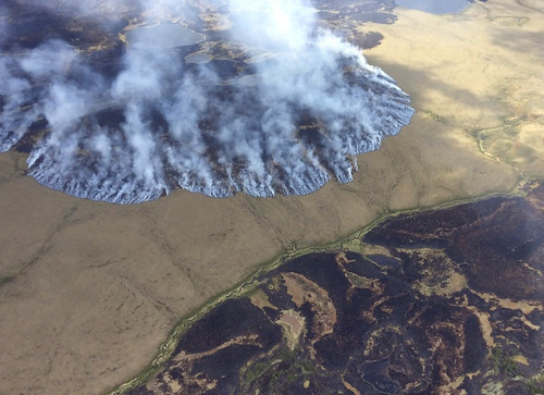
The Bogus Creek Fire
The Bogus Creek Fire burns in the Yukon Delta National Wildlife Refuge in southwest Alaska, June 7, 2015. Photo credit: Matt Snyder-Alaska Division of Forestry
You don’t have to be a rocket scientist to know that wildfires are more common during hot, dry summers. The area burned in the United States in 2015, over 10 million acres, according to the National Interagency Fire Center, occurred during a record temperature year for the Earth, plus record low snowpack and rainfall in some areas of the West.

The sizzling weather of 2015 was similar to what global climate models project for the year 2060. Last year’s weather and fire may become the new normal later in the 21st century.

A warmer climate is expected to increase the frequency and severity of fires. Historically, fires most often occur in the western U.S., as well as the boreal forest and tundra of Alaska. Current models predict that two to three times more area will burn annually in the West by 2050. This is a significant change in how wildfire will affect ecological systems and human communities in the future.

A longer fire season and bigger fires in Alaska would have a significant effect on the global carbon cycle. Organic soils in boreal forests and tundra contain up to 30 percent of the Earth’s terrestrial carbon, which can be released to the atmosphere by intense wildfires that burn deep into the soil. Temperature is increasing fastest at northern latitudes, thus increasing opportunities for wildfire to occur.

Foresters manage fuels to reduce fire intensity, vegetation mortality and damage to structures. In the Southeastern U.S., most pine forests are treated with prescribed fire every few years, keeping surface fuels and tree densities low to reduce the risk of fire. Forest thinning, prescribed fire and other means of fuel removal reduce fire intensity in dry forests in the western U.S.

Increasing temperatures coupled with increased wildfire will create new ecological and social challenges for federal resource managers. Warmer temperatures increase the complexity of conservation in terrestrial and aquatic ecosystems, threaten homes in the wildland-urban interface, and make the task of fire suppression even more costly.

By identifying “hot spots” where future wildfire may be especially pervasive and damaging to resources, the U.S. Forest Service and other federal agencies are developing adaptation options and locations where fuel treatments can be prioritized. They are also working with local communities to ensure that residents are prepared to live in areas where fire hazard is high.

Tuesday, May 24, 2016

CA-BEU Metz Fire - Monterey County Wildfire

Metz Fire - Monterey County wildfire - CAL FIRE San Benito-Monterey Unit

 CAL FIRE spokesman Daniel Berlant said that the growth slowed after sundown Sunday.
The blaze broke out at about 3:30 p.m. Sunday and had burned just 800 acres in its first two hours but then surged to nearly 3,876 acres amid strong winds, as of 8 a.m. Monday.
The fire is burning near Soledad in Monterey County between the Salinas River and Pinnacles National Park.
Monterey County wildfire (May 22, 2016)
Credit: KSBW

Location: Metz Rd & Blue Jay Ln, southeast of Soledad, Monterey County.
Date/Time Started: May 22, 2016 3:27 pm
Updates: 

5-23-16 1900: 3,876 acres - 70% contained

Estimated - Containment: May 25, 2016
Total Fire Personnel: 102
Total Fire Engines: 10
Total Fire crews: 4
Total Water Tenders: 1
Conditions: A passing disturbance will maintain a cool and unstable air-mass over the region. Below average temperatures will assist in containment efforts. Isolated showers and thunderstorms are possible in the afternoon and evening.
5-22-16 0900:  3,876 acres; 50% contained Fire did not spread overnight.

Friday, April 29, 2016

CAL FIRE Seeking $90+ Million in Firefighting Costs from Pacific Gas & Electric Company

CAL FIRE Blames PG&E for Butte Fire, Seeks $90 Million

A firefighter looks at an automatic teller machine after the Butte Fire destroyed the Golden Spur mini market north of Murphys, California on September 13, 2015, near san Andreas, California. David McNew / Getty Images


Heather Peterson and Ryan Harris

CAL FIRE says they will seek more than $90 million in firefighting costs from Pacific Gas & Electric Company after their findings show PG & E was at fault for the Butte Fire

The California Department of Forestry and Fire Protection released a report Thursday detailing the cause of that 2015 deadly fire in Calaveras and Amador counties. They say it was sparked by a tree that came into contact with a power line.
CAL FIRE says the state's largest utility or its contractors had removed two gray pine trees from a stand in January 2015, exposing a weaker, skinnier interior tree. The 44-foot-tall gray pine tree grew taller, seeking the sun, but eventually slumped into a power line, according to the report.

CAL FIRE's Daniel Berlant says utilities have a legal responsibility to make sure no trees or plants come into contact with its lines, which can start wildfires like the Butte Fire.

The fire started September 9 and burned for three weeks. It killed two people and destroyed more than 900 structures, including some 550 homes.


CAL FIRE says the amount they are seeking is believed to be the largest recovery amount ever sought by Cal Fire. The fire caused an estimated $300 million in insured losses and is the seventh-most destructive wildfire in state history.

The agency forwarded the results of its investigation to Calaveras and Amador County prosecutors, which could seek criminal charges against the utility.

Calaveras County supervisors also say the county will pursue all legal avenues and plans to seek hundreds of millions of dollars in compensation from PG & E.

“We are shocked and dismayed by the extent of PG& E’s negligence and will actively seek justice for Calaveras County and its citizens,” said Cliff Edson, Chair of the Calaveras County Board of Supervisors. “We will work tirelessly to secure rightful compensation for the County and our residents who are still grieving from the loss of loved ones, their livelihoods, homes, belongings and mementos, and all destroyed and taken from them because of PG&E’s carelessness and negligence.”

“We hold PG& E management and executives responsible for what happened here,” added Edson. “We want to acknowledge the hard work and assistance of PG& E’s excellent field staff for all their efforts and dedication in response and the recovery in Calaveras County. The working men and women of PG& E have made a difference and we thank them.”

Pacific Gas And Electric Company issued a statement in response:

"Our thoughts and prayers are with the victims and the individuals who lost their homes in the Butte fire. We are reviewing CAL FIRE’s report in its entirety. As we’ve said since September 16, we cooperated fully with CAL FIRE in its investigation on the source of the ignition for the Butte fire. We are committed to doing the right thing for our customers and will respond in the normal legal process."

Source: Posted April 28th, 2016 @ 12:03pm by KFBK News - Heather Peterson and Ryan Harris
Read more: http://kfbk.iheart.com/articles/kfbk-news-461777/cal-fire-blames-pge-for-butte-14657086/ixzz479QTaaxU/#ixzz47BzMB6MR

Tuesday, April 19, 2016

Military Vets Preparing To Deploy On New Fire Mission As Wildland Firefighters

Their military duties are done, but they want to keep serving. Dozens of veterans are preparing to deploy again to fight a very different enemy.


Team Rubicon trains Fifty military veterans to do battle with a new enemy wildfire as Wildland Firefighters


ORCAS ISLAND, Wash. -- It’s a world away from the desert sands of Iraq, but it was still a something of a combat mission on Orcas Island, Monday. Fifty military veterans prepared to do battle with a new enemy: wildfire.

“It's very dangerous, but I think our members are used to that sort of risk,” said Vince Moffitt, a member of Team Rubicon.

Team Rubicon is an international organization of American military veterans who volunteer to serve on disaster and relief missions around the globe. The group is now partnering with the Bureau of Land Management to train firefighters to combat wildfires in Washington and beyond. They’ve trained a total of 500 veterans for duty over the past two years.

“These men and women have seen a lot, and they’re exactly what we need,” said the BLM’s Chuck Russell. “They know how to think fast, act fast and have each other’s backs. We’re honored to have them.”

Last year's record wildfires stretched fire crews dangerously thin across the west. Three firefighters died fighting the flames near Twisp. The addition of these skilled veterans is critical for what will be another unpredictable fire season.

“They're used to chaos,” said Moffitt. “They go out there in very stressful situations, and they handle them very well.”

Among those feeling the call to serve once again is Iraq war vet Jay Pense. He has a very personal call to duty. A close buddy was killed in action by an insurgent sniper in Iraq. This will be Pense's second wildfire season with Team Rubicon. He does it, in part, because he knows his buddy would want him to.

“To be able to impact the people in a positive way is important to me and all of us,” he said.

To learn more about Team Rubicon, visit their website.

Source; http://www.king5.com/news/local/military-veterans-prepare-for-wildfire-season/140783609

Friday, September 11, 2015

CA-BTU LUMPKIN FIRE Wildfire Butte County East of Oroville. [MAP]

LUMPKIN FIRE CA-BTU-0013357 Wildfire Butte County East of Oroville

Fire currently threatens the Community of Robinson Mill and Feather Falls Commercial Timber, PG&E, & South Feather Water & Power.

LOCATION MAP 
Lumpkin Fire Location And Perimeter Map


Updates: 
09/15/2015 0745: 850 acres, 20% contained,

09/15/2015 0800: 850 Acres 20% contained.  Signifigant progress in dozer and handline construction. Working towards holding the established containment line(s). Fire increased in size moderatley

last night.

09/14/2015 1800: 800 acres, 20% contained, Fire currently threatens the Community of Robinson Mill and Feather Falls Commercial Timber, PG&E, & South Featehr Water & Power.


09/14/2015 1420: 800 acres, 20% contained. The fire has spotted over the containment lines and is moving towards the southeast. Structures are threatened.


09/14/2015 0700: 525 acres, 25% contained.


09/13/2015 1915: 525 acres 25% contained.


09/12/2015 0630: 225 acres, 10% contained. Moderate fire behavior with long range spotting.

09/11/2015 1800: 125 acres, 10% contained. Structures remain threatened.


09/11/2015 1500: 50 acres, 0% contained, burning in brush and timber. Structures threatened. Fire is located on Lumpkin Road x Forbestown Road near Robinson Mills.


Location: Butte Robinson Mill/East of Oroville

Incident Command: David Hawks - CAL FIRE IC
Joe Tapia - CAL FIRE Duputy IC
Safety/Threat Remarks: High humidity and heat steep terain and rolling material.

Wednesday, August 12, 2015

Air Tanker News: New Supertanker to be the fastest, longest-range, and most effective aerial firefighting platform in the world.

 Global SuperTanker Services, LLC, a subsidiary of Cyterna Air LLC, is pleased to announce completion of a definitive agreement to convert and operate Boeing 747-400 aircraft to be the fastest, longest-range, and most effective aerial firefighting platform in the world.

"Definitive agreement to convert and operate Boeing 747-400 aircraft to be the fastest, longest-range, and most effective aerial firefighting platform in the world."

Evergreen 747 Supertanker departs Ben Gurion Airport, Israel, (2007)
Credit: Wikipedia
 Cyterna Air, LLC is a portfolio company of an investment fund managed by private equity firm Alterna Capital Partners.

Jim Wheeler, President and CEO of Global SuperTanker Services has re-assembled core members of the former Evergreen Supertanker project team to install the pressurized tank system previously proven in a 747-100 with the significantly higher-performance and lower operating cost modern B747-400BCF (Boeing Converted Freighter).

The aircraft has a number of unique capabilities, including the ability to stand by on the ground fully loaded, deliver a variety of firefighting agents, respond rapidly over long distances, loiter over fire areas for extended periods, segment drops and land fully or partially loaded to avoid wasting firefighting agents.

 The SuperTanker operates from most designated VLAT bases staying close to the fire location saving time and fuel.

Wheeler commented, “The current worsening trends in wildfires globally demand more capable response tools. The Boeing 747-400 represents a modern, strong, high performance platform capable of flying more than 4000 nautical miles at a cruise speed of 565 miles per hour, at pressurized altitudes, fully loaded, then directly deploying nearly 20,000 gallons of a range of liquids including retardant, water, gel and foaming agents. We believe the Global SuperTanker will be a “force multiplier” for the men and women who are on the front line of controlling wildfires".

Harry Toll, Managing Partner of Alterna Capital commented, “Alterna invests capital to build valuable capabilities in vital industries. We believe strongly that the SuperTanker will add a new dimension to protecting forests, homes and lives through a powerful combination of speed, capacity and precision. In the US and many countries around the world there is an effort to deploy a ‘new generation’ of aerial tankers. We are working to deliver this and other aircraft to meet that need.”

For information about Global SuperTanker Services, LLC contact Jim Wheeler (855) 910-4562 or jim(dot)wheeler(at)globalsupertanker(dot)com.
For Information about Alterna Capital, LLC contact Harry Toll (203) 557-9024 or harry(dot)toll(at)alternacapital(dot)com .

Wednesday, August 5, 2015

DEER HORN # 2, CA-HIA-15-181 Wildfire Humboldt Deerhorn Ridge, Hoopa CA.

DEER HORN # 2, CA-HIA-15-181 Wildfire Humboldt Deerhorn Ridge, Hoopa CA.

Update 08/05/2015 1800: 125 Acres 90%, Fire activity continues to fluxgate from moderate rates of spread, to torching. Crews continue to install a hose lay, and improve hand and dozr line

IA IC: Rod Mendes, HIA ICT 3
Raldon Brown, HIA ICT 3 (T)
Location: Humboldt Deerhorn Ridge in Hoopa CA.
Fuel Model: Timber (Grass and Understory) 
Life, Safety, and Health Status/Threat Remarks: Narrow roads, steep terrain, large snags, and rolling material are a major concern at this time. Fire behavior fluxuates from moderate down to smoldering.
Current threat and risk potential are minimal resources on the fire line, as well as steep terrain and potential for roll out.

Friday, July 17, 2015

CA-BDF- North Fire: Vegetation Fire San Bernardino County SOCAL IMT #3 Wakoski [Active Fire Map]

NORTH FIRE - CA-BDF-North - Vegetation Fire San Bernardino County

All evacuation orders and road closures have been lifted. Repopulation in the communities of Baldy Mesa and Oak Hills has begun

There have been no injuries. Multiple vehicles on Interstate 15 caught on fire when the North Fire crossed southbound lanes. 20 vehicles were destroyed, 10 damaged, 4 structures have been destroyed.

The fire eventually spread to a nearby residential/farming area and another 44 cars, three homes and eight outbuildings were lost. The firefighting crew of 1,000 was aided Saturday when storms moved in off the coast. As of 7 p.m. Saturday the fire had burned about 3,500 acres was 45 percent contained.

Update 7-19-15 1830: 4,250 acres, 75% Contained
Incident has transitioned to SOCAL IMT #3 Wakoski
CAL FIRE Team 5 (Smith) activated but not used on the incident
Repopulation in the communities of Baldy Mesa and Oak Hills continues.
Thunderstorms over the fire today resulted in flash flooding
The fire will not be staffed for night shift while conditions are reevaluated
18 vehicles, 2 big rigs burned in fast moving wildfire
Credit:  The Sun
#NorthFire 
Evacuations: Mandatory Evacuations for Baldy Mesa area, east of Sheep Creek rd., North of I-15, West of Hwy 395 and South of Phelan Rd. 
Mandatory evacuations in Baldy Mesa for areas: 
East of Sheep Creek Road
North of Hwy 138
West of I-15/Hwy 395
South of Phelan Road
(Please see the Evacuation Zone Map)
Evacuation Center for residents is at Serrano High School 9292 Sheep Creek Rd, Phelan
Animals can be taken to the Victor Valley Fairgrounds 14800 7th Street, Victorville
Evacuation center located at Serrano High School: 9292 Sheep Creek Rd. Phelan 92371Phone Numbers (909) 383-5688 (Public Call Center)
Road Closures: I-15 opened in both directions, One I-15 Southbound lane remains closed North / South Bound I-15 Lanes Shut Down Southbound Interstate 15 is closed. Northbound I-15 has two lanes open, but traffic is slow. Motorists are advised to avoid the area if possible.


Fire map:


P2V-5 Tanker 44  west flank of the North Fire
 P2V-5 Tanker 44  west flank of the North Fire
Credit: Steve Whitby

CAL FIRE AT-72 - S-2 west flank of the North Fire
CAL FIRE AT-72 - S-2 west flank of the North Fire, Phelan Rd. and Baldy Mesa Rd. last night
Credit: Steve Whitby

Update 7-19-15 0830: 3,500 acres, 60% Contained
Incident has transitioned to SOCAL IMT #3 Wakoski
CAL FIRE Team 5 (Smith) activated but not used on the incident, 


Update 7-18-15 0830: OSCC - 3,500 acres, 5% Contained, 1000+ firefighters on scene
SOCAL IMT #3 Wakoski has been mobilized to incident
Wakoski scheduled to attend in briefing at 1200 today
CAL FIRE Team 5 (Smith) activated
I-15 opened in both directions, One I-15 Southbound lane remains closed
Structures remained threatened in the Baldy Mesa Area

Update 7-17-15 1930: 3,500 acres; 5% contained. - 18 vehicles, 2 big rigs burned.
Fire is in unified command with San Bernardino County Fire, CALFIRE, and San Bernardino County Sheriff.
Resources responding include: 22 engines
2 crews
4 water tenders
1 dozer
1 air attack plane
1 lead plane
3 helicopters
6 fixed wing tankers


Update 7-17-15 1830: AA says around 5000 acres now. ROS slow

Update 7-17-15 1630: 3,500 acres, 35% contained, 2 injuries, mandatory evacuations.

Update 7-17-15 1530:  Sheep creek drive any type engines 10 total for structure protection, IC requesting 5 additional AT's or the VLAT. IC just declared an MCI on the freeway civilian injuries from being burn over on the freeway, Per AA all air craft to protect life on the I-15 freeway.


Update 1435: Dispatch per WildCAD
07/17/2015 14:33 . 12E4/12K4 12E5 12E6 68R6 AA 12 ANF E338 ANF E37 BC31 BC32 CH1 CREW 1 CREW 5 DIV3 DIV9 Dozer 3 E12 E13 E16 E17 E19 E30 E31 E311 E314 E336 E337 E338 E339 E34 E35 E3637 E3648 E3R E51 E54 H301 H534 H554 PT33 Safety 1 WT12 WT234 WT32 WT56 BDF-9001
NORTH Wildfire NB 15 BETWEEN 138 AND OAKHILLS P5JY2D ENGR 33 Effective 
1425 34.318 x 117.510

North Fire Incident Information:Date/Time Started: July 17, 2015 2:50 pm Administrative Unit: CAL FIRE San Bernardino Unit/ San Bernardino National Forest / San Bernardino County Fire Location: Highway 15 and Highway 138, north of Cajon Junction.GPS: Long/Lat: -117.478 longitude/34.339 latitude.Structure threats: Yes, Destroyed: 18 vehicles, 2 big rigs

Saturday, June 20, 2015

CA-MNF San Hedrin Fire east of Willits, CA. 25 acres, 100% cont. Burning in heavy timber

San Hedrin Fire CA-MNF San Hedrin Fire

Update 7-20-15 0800: 25 acres, 100% contained.

Update 7-20-15 0800: 25 acres, 0% contained. Forward progress has been stopped.

Location: Fire is located 14 miles east of Willits, CA.
Fuels: Burning in heavy timber.  

---------------------------------------------

Saturday, September 13, 2014

CA-CNF- #SilveradoFire 1,600 Acres 10% Cont. / Mandatory Evacuations (Map)

CA-CNF- Silverado Fire
CNF Silverado Canyon Fire

Mandatory Evacuations: Per the Orange County Sheriff’s Dept. Mandatory Evacuations for Silverado Canyon. American Red Cross has established an evacuation center at El Modena High School, Approximately 250 structures threatened.
Road closures include: North Main, Indian Truck, Bedford, Maple Springs Rd, and Silverado Canyon Road.

Notes: 9/13/14 0700: 


  • Fire camp located at Irvine Regional Park
  • 10% contained; 3 firefighters treated for minor heat related injuries. 
  • The blaze was initially reported at about 15 acres, burning in Silverado Canyon near the Orange/Riverside County border
Basic Information
Current as of 9/12/2014 11:54:09 PM
Incident Type - Wildfire
Cause - Unknown
Date of Origin - Friday September 12th, 2014 approx. 10:30 AM
Location - Silverado Canyon
Incident Commander - USFS

Current Situation
Total Personnel - 280
Size - 1,600 Acres
Fuels Involved - grass /brush

Map: 
Active Fire Map Silverado Fire

---------------------------------------------

Wednesday, June 4, 2014

Coffee Break Training: Know Your Wildfire Role Part 1 of 2

Residents and Homeowners
Firefighters can’t always protect every home from wildfire — especially if property owners haven’t done their part to prepare. Property owners can take important steps around the home to make it safer for them, their family and their neighbors. Start now by setting an example and helping to create Fire-Adapted Communities (FACs) before the next fire approaches!
• Talk to the local fire department about how to prepare for a wildfire, situational awareness before a fire, when to evacuate, and what you and your community should expect during a response.
• Use the Wildfire Home Assessment and Checklist to conduct a risk assessment on your property.
• Create a plan to address issues in your property’s home ignition zone/defensible space, including:
– Maintaining a “fire-free” area around the perimeter of your home.
– Managing vegetation along fences.
– Clearing debris from decks, patios, eaves and porches.
– Selecting proper landscaping and plants.
– Knowing the local ecology and fire history.
– Moving radiant heat sources away from the home (i.e., wood piles, fuel tanks, sheds).
– Thinning trees and ladder fuels around the home.
• Develop a personal and family preparedness plan.
• Support land management agencies by learning about wildfire risk-reduction efforts, such as using prescribed fire to 
manage local landscapes.
• Contact the local planning/zoning office to find out if your home is in a high wildfire risk area and if there are specific 
local or county ordinances you should be following.
• If you have a homeowners’ association, work with them to identify regulations that incorporate proven preparedness landscaping, home design, and building materials use, such as Firewise.
Fire and Emergency Responders
Fire departments and emergency responders engage and educate residents about properly preparing for wildfire and building situational awareness. Studies show that you are uniquely qualified to prepare residents for wildfire because you are respected in your community and seen as a trusted source of information by the public. Use your role to help create FACs and do the following:
• Sign up for and participate in the Ready, Set, Go! Program.
• Do a local wildfire risk assessment for your community to identify high fuel loads, vulnerable building stock, and 
vulnerable populations.
• Provide input to the local Community Wildfire Protection Plan.
• Ensure fire department’s proficiency in wildland fires, fuels, operational techniques, safety procedures, qualifications, equipment and response.
• Review construction developments in the Wildland Urban Interface.
• Know availability of fire suppression resources and the public’s expectation of response.
• Discuss current level of preparedness/response collaboration with local emergency management and public safety agencies.
• Promote role of secondary assets like Fire Corps or Community Emergency Response Teams.
• Build relationships with planning, zoning, and building code development and enforcement staff.
Additional Resources
• U.S. Fire Administration’s Wildfire … Are You Prepared? at www.usfa.fema.gov.
• Ready.gov: www.ready.gov/wildfires.

Photo Credit of Image 2: CAL FIRE, www.fire.ca.gov

---------------------------------------------
Wednesday, May 14, 2014

Coffee Break Training: Wildfire — Are You Prepared?

Wildfire — Are You Prepared? (Part 2 of 2)
No. CR-2014-9 May 14, 2014

Learning Objective: The student will be able to identify the steps necessary to be prepared ahead of a wildfire threat and to 
practice wildfire safety.
If you are warned that a wildfire is threatening your area, listen for reports and evacuation information. Follow evacuation guidance provided by local officials. When wildfire threatens, you will not have time to shop or search for emergency supplies. Preassemble a disaster supply kit with items that you may need if advised to evacuate. Prepare ahead, and practice wildfire safety.

Prepare Yourself and Family — Plan Ahead:
• Plan and practice two ways out of your neighborhood in case your primary route is blocked.
• Select a place for family members to meet outside your neighborhood in case you cannot get home or need to evacuate.
• Identify someone who is out of the area of contact if local phone lines are not working.
• Be ready to leave at a moment’s notice.

Emergency Supplies:
Assemble a disaster supply kit with items that you will need if advised to evacuate in advance. Visit www.ready.gov or www.redcross.org for a current listing of supplies.
At a minimum, include:
• Water — one gallon of water per person per day (three-day supply).
• Food — nonperishable, easy-to-prepare items (three-day supply).
• A first-aid kit.
• Medications, prescription medications and medical items.
• Emergency tools, including a battery-powered or hand-crank radio, flashlight and extra batteries.
• An extra set of car keys and a credit card, cash or traveler’s checks.
• Sanitation and personal hygiene items.
• Special items for infants and elderly or disabled family members.
• An extra pair of eyeglasses.
• Cellphone/Charger.
• One change of clothing and footwear per person.
• One blanket or sleeping bag per person.
• Family and emergency contact information.
• Copies of personal documents (medication list, pertinent medical information, birth certificates, deed/lease to home, insurance policies).
• Map(s) of the area.
• Other essential items that could not be replaced if they were destroyed.

If Advised To Evacuate, Do So Immediately:
• Wear protective clothing — sturdy shoes, cotton or woolen clothing, long pants, a long-sleeved shirt, gloves, and a handkerchief to protect your face.
• Take your disaster supply kit.
• Lock your home.
• Tell someone the time you left and where you are going.
• Choose a route away from fire hazards. Watch for changes in the speed and direction of fire and smoke.
For additional information, visit www.usfa.fema.gov/citizens/.
Photo credit: SFGate

---------------------------------------------

Wednesday, April 30, 2014

CA-LPF/KCFD #SchoolFire 238.5 acres 100% Contained.

School Fire Wildfire Los Padres National Forest CA-LPF-1126


Update 5-1 1850: 238.5 acres, 100% contained.
Fire will be in patrol status overnight.
Update 1850: 238.5 acres and 60% contained.  Unified Command; Kern County and Los Padres NF.  Moderate rate of spread.

School Incident. 238 acres. Fixed wing aircraft are being released. Crews will be on scene for several hours to mop up. This is now under the administration of the Los Padres National Forest.
Location: Los Padres National Forest Bitter Creek Preserve

Kern County Fire Agency Facebook: http://fb.me/1pRgSTHSn


---------------------------------------------

Thursday, January 23, 2014

LTBMU Luther Pass South Lake Tahoe Prescribed Fire Information #CaFire #NvFire

 
U.S. Forest Service
Lake Tahoe Basin Management Unit (LTBMU)


Date Sent:  Jan. 23, 2014

Prescribed fire activity continues on Luther Pass
U.S. Forest Service fuels management crews resumed prescribed fire operations today, January 23, 2014, off of Highway 89 S near South Lake Tahoe.  Crews are burning piles in the Luther Pass campground and will continue operations through Friday, January 24, 2014, weather and conditions permitting. 

All prescribed fire projects are conducted in accordance with an approved prescribed fire burn plan.  Burn plans describe specific conditions under which operations are conducted including the weather, number of personnel, opportunities to minimize smoke impacts, and available burn days.  This information is used to decide when and where to burn.

Smoke from prescribed fire may continue for several days after the initial ignition.  Smoke that settles in low lying areas in the morning usually lifts out of the area during normal daytime heating.  All prescribed fires are monitored regularly for burning and smoke dispersal and action is taken to mitigate concerns as they arise.  The Forest Service makes every effort to conduct prescribed fire operations during weather patterns that carry smoke away from communities. 

Last summer’s wildfires serve as a reminder of the importance of fuels reduction and that smoke produced during a prescribed fire is less intense and of shorter duration than that of a wildfire.  For more information on prescribed fire and smoke management tips, visit http://www.fs.usda.gov/goto/ltbmu/RxFireOps.

Forest Service staff post road signs around the areas affected by the prescribed fire, send email notifications, and update the local fire information line at 530-543-2600, #6.  To receive prescribed fire notifications, send an email to pa_ltbmu@fs.fed.us.
To learn more about the efforts to reduce wildfire risks in the Tahoe Basin read the Lake Tahoe Basin Multi-jurisdictional Fuel Reduction Plan found at http://fs.usda.gov/Internet/FSE_DOCUMENTS/fsm9_045864.pdf.
Visit an excellent web site and learn about Prescribed Fire vs. Wildfire at: http://www.smokeybear.com/prescribed-fires.asp. 
Source:
Lisa Herron
Public Affairs Specialist
U.S. Forest Service
Lake Tahoe Basin Management Unit
35 College Drive
South Lake Tahoe CA 96150
laherron@fs.fed.us
---------------------------------------------

Twitter Buttons

****REMINDER**** Every fire has the ability to be catastrophic. The wildland fire management environment has profoundly changed. Growing numbers of communities, across the nation, are experiencing longer fire seasons; more frequent, bigger, and more severe, fires are a real threat. Be careful with all campfires and equipment.

"I am a firm believer in the people. If given the truth, they can be depended upon to meet any national crisis. The great point is to bring them the real facts, and beer." --Abraham Lincoln

View blog top tags
---------------------
CLICK HERE TO GO BACK TO TOP OF CALIFORNIA FIRE NEWS HOME PAGE

Subscribe via email to California Fire News - Keep track of Cal Fire News

Enter your email address:

Delivered by FeedBurner