Wednesday, February 11, 2015

Forest Service Fire Operations Risk Management: Standard Firefighting Orders and 18 Watchout Situations


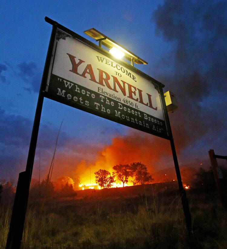
 Post In Memory: Granite Mountain Hotshots, the 19 firefighters who died battling the Yarnell Hill Fire on June 30, 2013. 
Standard Firefighting Orders and 18 Watchout Situations

The original ten Standard Firefighting Orders were developed in 1957 by a task force commissioned by the USDA-Forest Service Chief Richard E. McArdle. The task force reviewed the records of 16 tragedy fires that occurred from 1937 to 1956. The Standard Firefighting Orders were based in part on the successful "General Orders" used by the United States Armed Forces. The Standard Firefighting Orders are organized in a deliberate and sequential way to be implemented systematically and applied to all fire situations.

Shortly after the Standard Firefighting Orders were incorporated into firefighter training, the 18 Situations That Shout Watch Out were developed. These 18 situations are more specific and cautionary than the Standard Fire Orders and described situations that expand the 10 points of the Fire Orders. If firefighters follow the Standard Firefighting Orders and are alerted to the 18 Watch Out Situations, much of the risk of firefighting can be reduced.

Standard Firefighting Orders
  1. Keep informed on fire weather conditions and forecasts.
  2. Know what your fire is doing at all times.
  3. Base all actions on current and expected behavior of the fire.
  4. Identify escape routes and safety zones and make them known.
  5. Post lookouts when there is possible danger.
  6. Be alert. Keep calm. Think clearly. Act decisively.
  7. Maintain prompt communications with your forces, your supervisor, and adjoining forces.
  8. Give clear instructions and insure they are understood.
  9. Maintain control of your forces at all times.
  10. Fight fire aggressively, having provided for safety first.
18 Watchouts Situations
  1. Fire not scouted and sized up.
  2. In country not seen in daylight.
  3. Safety zones and escape routes not identified.
  4. Unfamiliar with weather and local factors influencing fire behavior.
  5. Uninformed on strategy, tactics, and hazards.
  6. Instructions and assignments not clear.
  7. No communication link with crewmembers/supervisors.
  8. Constructing line without safe anchor point.
  9. Building fireline downhill with fire below.
  10. Attempting frontal assault on fire.
  11. Unburned fuel between you and the fire.
  12. Cannot see main fire, not in contact with anyone who can.
  13. On a hillside where rolling material can ignite fuel below.
  14. Weather is getting hotter and drier.
  15. Wind increases and/or changes direction.
  16. Getting frequent spot fires across line.
  17. Terrain and fuels make escape to safety zones difficult.
  18. Taking a nap near the fire line.

Source: http://www.fs.fed.us/fire/safety/10_18/10_18.html
---------------------------------------------

Monday, February 9, 2015

Australia: Tree falls on a fire truck yesterday afternoon where four firefighters were inside the cabin.


An incident has occurred at the Western Australia fires involving six Victorian firefighters.
 The firefighters were fortunate to escape serious injuries
Photo supplied by Dept Parks & Wildlife, Western Australia
 A tree fell on a fire truck yesterday afternoon where four firefighters were inside the cabin. The firefighters were fortunate to escape serious injuries as the large tree fell over the rear of the truck which was operating in the forest.
Another two firefighters witnessed the incident. All six firefighters are safe however two firefighters received minor injuries from the sudden impact on the truck.

Source Wol Worrell‎ - https://www.facebook.com/photo.php?fbid=511829088956174&set=gm.10152688494612913&type=1&permPage=1

---------------------------------------------

Northern California seasonal outlook has been updated for March through May. NORMAL ACROSS ALL AREAS


Northern California seasonal outlook has been updated for March through May. http://gacc.nifc.gov/oncc/predictive/outlooks/Seasonal_Outlook.pdf
NORMAL ACROSS ALL AREAS

The previously developing El Nino has fallen apart rapidly in the past several weeks and is no longer expected to be a factor this spring. However we do still expect to see some large scale weather patterns similar in some El Nino’s this spring, namely Above Normal Temperatures (Fig 1) and wetter than normal conditions across Southern CA (Fig 2). Drought conditions remain Extreme to Exceptional across most of Nrn CA (Fig 3) and these drought conditions are expected to persist thru April.

---------------------------------------------

YNP News: Celebration of Black History Month: Yosemite National Park "The Way Home" #CaParks

"The Way Home" 

In celebration of Black History Month, we are featuring "The Way Home," a short video featuring Ranger Shelton Johnson and the journey of the Amazing Grace 50+ Club, a Los Angeles-based senior group, to Yosemite National Park for the first time.


---------------------------------------------

Saturday, February 7, 2015

CA-OVD Van Dyke Fire - Unified Command Wildfire 509 acres 100% #CaFire

Van Dyke Fire CAOVD-107
Point Ranch S/O Bridgeport, Mono. Jurisdiction BLM
Rapid ROS Near Bridgeport


Update 2-11-15 0830 hours: 509 acres. 100% Contained.
Update 2-9-15 1830 hours: 509 acres 75% Contained. No change in conditions
Ground resources continue to Improve fire line, patrol, mop up.
Update 2-9-15 0815 hours: Fire is 509 acres 75%.
Update 2-7-15 2115 hours: 300+ acres fire continues to burn in sage, pinyon pine with re-burn potential as fuels are not being totally consumed.
Unified Command with BLM, USFS, Bridgeport Fire
A type 3 incident organization (Bureau of Land Management and USFS) is being assembled and located at the Bridgeport Ranger Station 

Location:  Point Ranch S/O Bridgeport, Mono County
IA Description:1652 hrs New Start, Point Ranch south of Bridgeport 150+ acres fire is active with dangerous rate of spread.
IA Weather: 48°, 36 % Humidity, 23 mph winds from the south, gusting to 37 mph
IA Resources: -
ROC:Power outage in Bridgeport affecting communication infrastructure
ROS: - Rapid and Dangerous
Structure Threats: Yes Threat to structures
Situation Concerns/Alerts: -
Situation Comments: -
Additional Resource Notes: Jurisdiction OVD Unified Command with OVD, USFS, Bridgeport Fire
Agency Website: -
Radio Frequencies: -
Online Scanners: -
Web Cams: -

---------------------------------------------

CA-BDU-Round 7000 acres, 95%. 40 Residence & Outbuildings Destroyed. NEW MAP #CAFire

CA-BDU-Round / Round FireCA-BDU-1662, vegetation, San Bernardino, West of Highway 395 at the Sherwin Grade

Initial Round Fire perimeter map: 
Round Fire perimeter map


Update 2-11-15 0900: Fire remains at 7,000 acres  95% contained.  
Update 2-9-15 1900: Fire remains at 7000 Acres of Sage and Bitterbrush, Jeffrey Pine and Pinyon Pine and is 95% contained.  Lower Rock Creek Road remains closed.
Update 2-9-15 0900: 7000 acres, 85% contained
  • Possible re-population today for the communities of Paradise and Swall Meadows if utility companies needs are met
  • No structures threatened
  • 40 residences destroyed as well as several out buildings
  • 5 residences damaged

On Scene Video:

Update 2-9-15 0700: 7,000 acres, 85% contained.The communities of Paradise & Swall Meadows remain under a mandatory evacuation.
Update 2-8-15 1700: 7,000 acres, 75% contained.
Update 2-8-15 0700: 7,000 Acres, 65% Contained, 40 Residence & Outbuildings Destroyed. 4 Water Tenders, 4 dozers, 35 engines, 29 fire crews, 1 helo.


CAL FIRE Update 2-7-15 1700: 
Round Fire Incident Information:
Last Updated:February 7, 2015 5:00 pm  
Date/Time Started:February 6, 2015 2:07 pm  
Administrative Unit:CAL FIRE San Bernardino Unit 
County:Inyo and Mono County  
Location:West of Highway 395 at the Sherwin Grade  
Acres Burned - Containment:7,000 acres - 50% contained  
Structures Destroyed:40 Residence & Outbuildings  
Evacuations:
The Town of Paradise & Swall Meadows are under a mandatory evacuation.
An evacuation center has been established at the Crowley Lake Community Center:
458 S. Landing Rd Crowley Lake, CA 93546

Click here for Directions to the Evacuation Center
There will be a community meeting at 6 p.m. tonight at the Round Valley School. 300 N Round Valley Road, Bishop, CA.
Road Closures :Roller Rock Creek Rd. at Toms Place and Gorge Rd on North side of Hwy 395  
Injuries:1  
Cause:Under Investigation 
Cooperating Agencies:Inyo USFS, Paradise Fire Dept., Inyo County Sheriff, Mono County Sheriff, CHP, LADWP, BSHOP Fire, Big Pine Fire, Independence Fire, Lone Pine Fire, Long Valley Fire, Wheeler Crest Fire, Edison and CDCR  
Total Fire Personnel:200  
Total Fire Engines:47  
Total Fire crews:29  
Total Dozers:2  
Conditions:Significant rain stopped the forward rate of the fire around 2am. Downed power lines and venting propane tanks make re-entry for residents dangerous  


CA-BDU-Round Sherwin Grade Fire via California Department of Transportation District 9 Facebook
 Town of Paradise and Swall Meadows still under mandatory evacuations with evacuees at Crowley Lake Community Center
in Inyo County 7,000+ acres burned. Via
Update 2-7-15 1000hrs: - 7,000 acres 30% 20 Structures & Outbuildings Destroyed (preliminary count)  
Update 2-7-15 1000hrs: - • 3000 acres, 0% contained
Town of Paradise and Swall Meadows still under mandatory evacuations with evacuees at Crowley Lake Community Center
• Voluntary evacuations for residents in Lower Rock Creek, Sunny Slopes and Tom's Place
• Winds erratic making conditions unsafe for fire crews and suppression efforts difficult
• 1 structure and 1 out building destroyed

Update 2-7-15 0900hrs: - 2 Strike Teams from San Bernardino Co. Many local gov. fire engines assisting @forestservice & @CAL_FIRE on #RoundFire Inyo County. 
Update 2-6-15 2230hrs: - 500+ acres. Significant rain stopped the forward rate of the fire around 2am. Downed power lines and venting propane tanks make re-entry for residents dangerous  
Update 2-6-15 2200hrs: - 100+ acres. Per LE moving into Swall Meadows. asking for Type 3 or Type 1 engines for structure defense.
Update 2-6-15 1900hrs: - 100 acres.

Location: - North of Bishop, west of highway 395, Sherwin Grade
IA Description: - 5 acres, Rapid spread
IA Resources: - CAL FIRE assisting the USFS, local gov. units and Big Sur Brigade
ROC: - 70-100 mph winds, low relative humidity
ROS: -
Structure Threats: - Yes moving into Swall Meadows. asking for Type 3 or Type 1 engines for structure defense. 20 Structures & Outbuildings (preliminary count)  destroyed
Situation Concerns/Alerts: -
Situation Comments: -
Additional Resource Notes: - 2 Strike Teams from San Bernardino Co. Many local gov. fire engines assisting INF is in unified but BDU is the UOP and has the IC

Inyo USFS, Paradise Fire Dept., Inyo County Sheriff, Mono County Sheriff, CHP, LADWP, BSHOP Fire, Big Pine Fire, Independence Fire, Lone Pine Fire, Long Valley Fire, Wheeler Crest Fire, Edison and CDCR


Agency Website: http://t.co/T1lt9SDdWy
Radio Frequencies: -
Online Scanners: -
Weather: Owens Valley RAWS winds SSW 10 Gust 27.

Web Cams: -
---------------------------------------------

TFFT Lake Tahoe Basin Multi-agency Prescribed Fire Operations Continue #CaFire


February 7, 2015                                                                               
Multi-agency prescribed fire operations continue next week

South Lake Tahoe, Calif. –The California Tahoe Conservancy, Nevada Division of Forestry and U.S. Forest Service may continue prescribed fire operations in numerous areas around the Lake Tahoe Basin next week beginning Monday, February 9, 2015. On the South and West shores of Lake Tahoe, operations may take place south of Tahoe City near Sunnyside, Gardner Mountain near South Tahoe High School, Christmas Valley, Luther Pass near Grass Lake, and Ski Run Boulevard near Heavenly. On the East Shore, operations may take place on lower Kingsbury Grade off Easy Street, Logan Creek Drive, the north side of Spooner Summit, Slaughterhouse Canyon and near Memorial Point at Sand Harbor. Operations will last through the next several weeks as conditions allow.

Fall and winter bring cooler temperatures and precipitation, which favor prescribed burning. Each operation follows a prescribed fire burn plan, which considers temperature, humidity, wind, moisture of the vegetation, and conditions for the dispersal of smoke. This information is used to decide when and where to burn. The Tahoe Fire and Fuels Team (TFFT) gives as much advance notice as possible before burning, but some operations may be conducted on short notice.

Smoke from prescribed fire operations is normal and may continue for several days after an ignition depending on the project size. Agencies coordinate with state and local county air pollution control districts and monitors weather conditions closely prior to prescribed fire ignition. They wait for favorable conditions that will carry smoke up and out of the Basin. Crews also conduct test burns before igniting a larger area, to verify how effectively fuels are consumed how smoke will travel.

Before conducting prescribed fire operations, agencies may post road signs around affected areas and make email or phone notifications. 


 The Forest Service updates the local fire information line at 530-543-2600, #6. To receive prescribed fire notifications, send an email to pa_ltbmu@fs.fed.us. For more information on prescribed fire and smoke management tips, visit http://www.fs.usda.gov/goto/ltbmu/RxFireOps.   

Burn Projects Information:
  • Project Name: Talmont/Tahoe Park Heights
  • Responsible Agency/Contact: California Tahoe Conservancy, Milan Yeates (530) 543-6058
  • Legal Location: T15N, R16E, Sec 13
  • Descriptive Location: West of Sunnyside
  • Type of Burn: Hand pile
  • Total Acreage: 18
  • Planned Ignition: 02/10/15 - 02/12/15
  • Duration of Ignition and Smoke Production: 5 days burn down time
  • Estimated Direction of Smoke Travel: North/northeast
  • Communities of Smoke Sensitive Areas: Smoke may be visible from Sunnyside, Talmont, Tahoe City and surrounding communities.
  • Project Name:  North Canyon Pile Burn
  • Responsible Agency/Contact:  Nevada Division of Forestry, Roland Shaw (775) 684-2741
  • Legal Location:  T15N, R18E, Sec 35,36
  • Descriptive Location:  Lake Tahoe Nevada State Park, 1 mile north of Spooner Summit, east of SR28
  • Type of burn:  Hand piles
  • Total Acreage:  10
  • Planned Ignition:  2/10/15 and continuing as conditions permit
  • Duration of Ignition and Smoke Production:  2 days of burn down time
  • Estimated Direction of Smoke Travel:  Northeast
  • Communities or Smoke Sensitive Areas:  Smoke may be visible from SR28, US50 in the Spooner Summit area, Tahoe Rim Trail north of Spooner Summit, Washoe Valley, and Carson City. 
  • Project Name:  Slaughterhouse Pile Burn
  • Responsible Agency/Contact:  Nevada Division of Forestry,Roland Shaw (775) 684-2741
  • Legal Location:  T15N, R18E, Sec 34
  • Descriptive Location:  Lake Tahoe Nevada State Park, 1.5 miles north of Spooner Summit, west of SR28
  • Type of burn:  Hand piles
  • Total Acreage:  5
  • Planned Ignition:  2/10/15 and continuing as conditions permit
  • Duration of Ignition and Smoke Production:  3 days of burn down time
  • Estimated Direction of Smoke Travel:  Northeast
  • Communities or Smoke Sensitive Areas:  Smoke may be visiblefrom SR28, US50 in the Spooner summit area, and north of Glenbrook. 
  • Project Name:  Sand Harbor Pile Burn
  • Responsible Agency/Contact:  Nevada Division of Forestry, Roland Shaw (775) 684-2741
  • Legal Location:  T15N, R18E, Sec 2; T16N R18E Sec 35
  • Descriptive Location:   Sand Harbor, Memorial Point
  • Type of burn:  Hand piles
  • Total Acreage:  20
  • Planned Ignition:  2/10/15 and continuing as conditions permit
  • Duration of Ignition and Smoke Production:  3 days of burn down time
  • Estimated Direction of Smoke Travel:  Northeast/east
  • Communities or Smoke Sensitive Areas:  Smoke may be visible from SR28, the north end of Lake Tahoe and Washoe Valley. 
  • Project Name:  Van Sickle Pile Burn
  • Responsible Agency/Contact:  Nevada Division of Forestry, Roland Shaw (775) 684-2741
  • Legal Location:  T13N, R18E, Sec 26
  • Descriptive Location:  Lake Tahoe Nevada State Park, Van Sickle Unit, south of Kingsbury with access via Palisades to end of Easy Street
  • Type of burn:  Hand piles
  • Total Acreage:  15
  • Planned Ignition:  2/10/15 and continuing as conditions permit
  • Duration of Ignition and Smoke Production:  3 days of burn down time
  • Estimated Direction of Smoke Travel:  Northeast/east
  • Communities or Smoke Sensitive Areas:  Smoke may be visible from SR207 and residential areas along Kingsbury Grade, Stateline, South Lake Tahoe, Heavenly Ski Area, and U.S. Highway 50 southbound at Round Hill. 
  • Project Name:  Heavenly ULM
  • Agency Contact:  U.S. Forest ServiceJohn Washington (530) 543-2652
  • Legal Location:  T12/13N, R18E, Sec 1, 34
  • Descriptive Location:  Ski Run Blvd., South Lake Tahoe, CA
  • Type of burn:  Hand Piles
  • Total Acreage:  70.25
  • Planned Ignition:  02/09/2015 and continuing as conditions permit
  • Duration of Ignition and Smoke Production:  10 days of burn down time
  • Estimated Direction of Smoke Travel:  North/Northeast
  • Communities or Smoke Sensitive Areas:  Smoke may be visible from Stateline, South Lake Tahoe and surrounding communities. 
  • Project Name:  Highland
  • Agency Contact:  U.S. Forest Service, John Washington (530) 543-2652
  • Legal Location:  12N, R18E, Sec 6
  • Descriptive Location:  Gardner Mtn. area, South Lake Tahoe, CA
  • Type of burn:  Hand piles
  • Total Acreage:  120
  • Planned Ignition:  02/09/2015 and continuing as conditions permit
  • Duration of Ignition and Smoke Production:  6 days of burn down time
  • Estimated Direction of Smoke Travel:  Northeast
  • Communities or Smoke Sensitive Areas:  Smoke may be visible from South Lake Tahoe and surrounding communities. 
  • Project Name:  Viking
  • Agency Contact:  U.S. Forest Service, John Washington (530) 543-2652
  • Legal Location:  12N, R18E, Sec 6
  • Descriptive Location:  Gardner Mtn. area, South Lake Tahoe, CA
  • Type of burn:  Hand piles
  • Total Acreage:  148
  • Planned Ignition:  02/09/2015 and continuing as conditions permit
  • Duration of Ignition and Smoke Production:  6 days of burn down time
  • Estimated Direction of Smoke Travel:  Northeast
  • Communities or Smoke Sensitive Areas:  Smoke may be visible from South Lake Tahoe and surrounding communities. 
  • Project Name:  Spooner CTL
  • Responsible Agency/Contact:  U.S. Forest Service, Kyle Jacobson (530) 543-2658
  • Legal Location:  T15N, R18E, Sec 11
  • Descriptive Location:  Hwy 28 north of Spooner Summit
  • Type of burn:  Hand/machine piles
  • Total Acreage:  84
  • Planned Ignition:  02/09/2015 and continuing as conditions permit
  • Duration of Ignition and Smoke Production:  10 days of burn down time
  • Estimated Direction of Smoke Travel:  North/Northeast
  • Communities or Smoke Sensitive Areas:  Smoke may be visible from Incline Village, Kings Beach and West Shore communities 
  • Project Name:  Logan 
  • Responsible Agency/Contact:  U.S. Forest Service, Kyle Jacobson (530) 543-2658
  • Legal Location:  T14N, R18E, Sec 22
  • Descriptive Location:  Logan House Community, near Logan Creek Drive, East Shore  
  • Type of burn:  Hand/machine piles
  • Total Acreage:  23
  • Planned Ignition:  02/09/2015 and continuing as conditions permit
  • Duration of Ignition and Smoke Production:  10 days of burn down time
  • Estimated Direction of Smoke Travel:  North/Northeast
  • Communities or Smoke Sensitive Areas:  Smoke may be visible from Incline Village, Kings Beach and West Shore communities 
  • Project Name:  Luther 
  • Responsible Agency/Contact:  U.S. Forest Service, Kyle Jacobson (530) 543-2658
  • Legal Location:  T11N, R18E, Sec 15
  • Descriptive Location:  Luther Pass/Grass Lake
  • Type of burn:  Hand
  • Total Acreage:  55
  • Planned Ignition:  02/09/2015 and continuing as conditions permit
  • Duration of Ignition and Smoke Production:  10 days of burn down time
  • Estimated Direction of Smoke Travel:  North/Northeast
  • Communities or Smoke Sensitive Areas:  Smoke may be visible from Meyers, South Lake Tahoe and South Shore communities as well as visitors traveling over Echo Summit and Luther Pass 
  • Project Name:  Bob White
  • Responsible Agency/Contact:  U.S. Forest Service, Kyle Jacobson (530) 543-2658
  • Legal Location:  T14N, R17E, Sec 29
  • Descriptive Location:  North of Emerald Bay
  • Type of Burn:  Hand piles
  • Total Acreage:  150
  • Planned Ignition:  02/09/2015 and continuing as conditions permit
  • Duration of Ignition and Smoke Production:  10 days of burn down time
  • Estimated Direction of Smoke Travel:  North/Northeast
  • Communities or Smoke Sensitive Areas:  Smoke may be visible from Tahoma and surrounding communities. 
  • Project Name:  Christmas Valley
  • Responsible Agency/Contact:  U.S. Forest Service, Kyle Jacobson (530) 543-2658
  • Legal Location:  T11N R18E sec. 29
  • Descriptive Location:  along Christmas Valley downhill trail
  • Type of Burn:  Hand piles
  • Total Acreage:  30
  • Planned Ignition:  02/09/2015 and continuing as conditions permit
  • Duration of Ignition and Smoke Production:  5 days of burn down time
  • Estimated Direction of Smoke Travel:  North/Northeast
  • Communities or Smoke Sensitive Areas:  Smoke may be visible from Meyers, South Lake Tahoe and surrounding communities.  
Contacts:         California Tahoe Conservancy, Milan Yeates 530-543-6058
                        Nevada Division of Forestry, Roland Shaw 775-684-2741
                        U.S. Forest Service, Lisa Herron 530-543-2815


###
About the Tahoe Fire and Fuels Team
The Tahoe Fire and Fuels Team (TFFT) consists of representatives of Tahoe Basin fire agencies, Cal Fire, Nevada Division of Forestry and related state agencies, the Tahoe Regional Planning Agency, the USDA Forest Service, conservation districts from both states, the California Tahoe Conservancy and the Lahontan Regional Water Quality Control Board.  Our Mission is to protect lives, property and the environment within the Lake Tahoe Basin from wildfire by implementing prioritized fuels reduction projects and educating the public on becoming a Fire Adapted Community.
For more information, visit www.tahoefft.org

---------------------------------------------

Twitter Buttons

****REMINDER**** Every fire has the ability to be catastrophic. The wildland fire management environment has profoundly changed. Growing numbers of communities, across the nation, are experiencing longer fire seasons; more frequent, bigger, and more severe, fires are a real threat. Be careful with all campfires and equipment.

"I am a firm believer in the people. If given the truth, they can be depended upon to meet any national crisis. The great point is to bring them the real facts, and beer." --Abraham Lincoln

View blog top tags
---------------------
CLICK HERE TO GO BACK TO TOP OF CALIFORNIA FIRE NEWS HOME PAGE

Subscribe via email to California Fire News - Keep track of Cal Fire News

Enter your email address:

Delivered by FeedBurner