Tuesday, January 7, 2014

LTBMU: Lake Tahoe Prescribed fire operations resume near Luther Pass. #CaFire

 
U.S. Forest Service
Lake Tahoe Basin Management Unit (LTBMU)


Prescribed fire operations resume near Luther Pass

U.S. Forest Service fuels management crews will resume prescribed fire operations at Luther Pass (Luther Pass, Eldorado National Forest)near South Lake Tahoe on Monday, January 6, 2014. Operations will continue as conditions allow.

Fall and winter bring rain, snow and cooler temperatures, which are ideal for prescribed fire operations.  All prescribed fire projects are conducted in accordance with an approved prescribed fire burn plan.  Burn plans describe specific conditions under which operations are conducted including the weather, number of personnel, and opportunities to minimize smoke impacts. This information is used to decide when and where to burn. 

Smoke from prescribed fire may continue for several days after the initial ignition.  Smoke that settles in low lying areas in the morning usually lifts out of the area during normal daytime heating.  All prescribed fires are monitored regularly for burning and smoke dispersal and action is taken to mitigate concerns as they arise. The Forest Service makes every effort to conduct prescribed fire operations during weather patterns that carry smoke away from communities.  Smoke-sensitive residents should consider staying indoors and keeping doors, windows and outside vents closed. 
Forest Service staff will post road signs around the areas affected by the prescribed fire, send email notifications, and update the local fire information line at 530-543-2600, #6. 

This summer’s wildfires serve as a reminder of the importance of fuels reduction and that smoke produced during a prescribed fire is less intense and of shorter duration than that of a wildfire.  For more information on prescribed fire and smoke management tips, visit http://www.fs.usda.gov/goto/ltbmu/RxFireOps. 

More Information:
Lisa Herron
Public Affairs Specialist
U.S. Forest Service
Lake Tahoe Basin Management Unit
35 College Drive
South Lake Tahoe CA 96150

---------------------------------------------

CA-LNF Campbell Fire: Lassen National Forest 772 acres, 80%. Minton, ICT2. #CaFire

Campbell Fire Wildland Fire Lassen National Forest 

Update 1/08/14 0800: 772 acres, 80% contained. Minton, ICT2. Minimal fire behavior as interior fuels continue to consume. Transition of fire back to the Unit planned for 1/9/14.
Update 1/07/14 1800: 746 acres, 55% contained. Minton, ICT2. Smoldering and creeping with no significant fire spread. Expected containment 1/8/2014.
Update 1/05/14 0800: 435 acres, 35% contained.
Update 1/04/14 0800: 175 acres, 50% contained.
Update 1/03/14 1800: 175 acres, 30% contained Expected containment 1/5/14 1800.
Update 1/03/14 0800: 200 acres, e0% contained

Location: East of Red Bluff.  Burning in the Ishi Wilderness.


---------------------------------------------

CA-HUU Red Fire: 333 acres, 70% Humboldt County Expect containment 1/9/14 #CaFire

CA-HUU Red Fire Wildland Fire Willow Creek Humboldt County

Update 1/8/14 0800: 333 acres, 70% contained. Expected containment 1/9/14
Update 1/7/14 0800: 355 acres, 65% contained. Expected containment 1/7/14.
Update 1/6/14 1800: 333 acres, 65% contained. Extreme terrain and limited access making mop up difficult.
Update 1/6/14 0800: 350 acres, 40% contained. Expected containment 1/7/14
Update 1/5/14 1800: 350 acres, 40% contained.
Update 1/5/14 0800: 250 acres, 20% contained.
Update 1/4/14 1900: 100 acres, 20% contained.
Update 1/4/14 1200: 15 acres . 0% contained, slow to moderate rate of spread. 

Location: West of Willow Creek, south of Berry Summit, Willow Creek, CA 95525, USA
IA Acres: 15
ROC: Burning in timber and slash
Resources:
Radio Frequencies: HUU Local (151.25) for Command CDF Tac 7 for tacticalOnline Scanner: http://www.broadcastify.com/listen/feed/1161
Online Scanner: http://www.broadcastify.com/listen/feed/7047


---------------------------------------------

Monday, January 6, 2014

CA-HUU-Light Fire 4-5 acres Humboldt County Minimal Fire Activity #CaFire

CA-HUU-Light Fire Wildland Fire Humboldt County

Update 1/7/14 1800: Minimal observed fire activity.
Update 1/5/14 0300: CA-HUU-Light 3939 lighthouse road. 2 fires. "Light IC," is 4-5 acres. Unable to determine size of second fireo"over the hill". Engines making way in off of Prosper Ridge Rd "4-5 miles in"
Location: Lost Coast of California. SW Humboldt County 
IA Acres: 4-5 acres ROC: Sgnificant fire, crowning, flames several hundred feet into air. Petrolia units are responding up the beach access." -
Resources: Petrolia Fire w/ Petrolia VFD Chief 6600, E1268
Honeydew Fire, 3 camp crews, Engines 2475 & 2679
Radio Frequencies: HUU Local (151.25) for Command CDF Tac 7 for tacticalOnline Scanner: http://www.broadcastify.com/listen/feed/1161
Online Scanner: http://www.broadcastify.com/listen/feed/7047
---------------------------------------------

Saturday, January 4, 2014

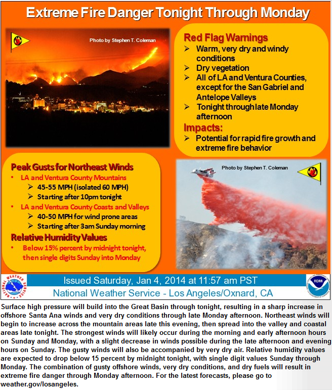
RED FLAG WARNING LOS ANGELES AND VENTURA COUNTIES FOR GUSTY NORTHEAST WINDS AND VERY LOW HUMIDITY #CaFire #CaWx #CaFireWx

URGENT - FIRE WEATHER MESSAGE RED FLAG WARNING IN EFFECT FROM LATE TONIGHT THROUGH MONDAY FOR MUCH OF LOS ANGELES AND VENTURA COUNTIES FOR GUSTY NORTHEAST WINDS AND VERY LOW HUMIDITIES WITH PEAK WIND SPEEDS EXPECTED LATE TONIGHT INTO SUNDAY.


URGENT - FIRE WEATHER MESSAGE
NATIONAL WEATHER SERVICE LOS ANGELES/OXNARD CA
310 PM PST SAT JAN 4 2014

...RED FLAG WARNING IN EFFECT FROM LATE TONIGHT THROUGH MONDAY
FOR MUCH OF LOS ANGELES AND VENTURA COUNTIES FOR GUSTY NORTHEAST
WINDS AND VERY LOW HUMIDITIES..

.STRONG SURFACE HIGH PRESSURE WILL BUILD INTO THE GREAT BASIN
TONIGHT INTO SUNDAY...TIGHTENING THE OFFSHORE PRESSURE GRADIENTS
ACROSS SOUTHERN CALIFORNIA. THIS OFFSHORE WIND EVENT IS TRENDING
STRONGER AND FASTER...WITH OFFSHORE WINDS EXPECTED TO INCREASE
SHARPLY AFTER MIDNIGHT TONIGHT. THE FOCUS OF STRONGEST WINDS WILL
BE ACROSS EASTERN VENTURA COUNTY AND WESTERN LOS ANGELES
COUNTY...WITH PEAK WIND SPEEDS EXPECTED LATE TONIGHT INTO SUNDAY.
DURING THE PEAK OF THE EVENT...WIND GUSTS BETWEEN 45 AND 55 MPH
WILL BE COMMON ACROSS THE MOUNTAINS OF LOS ANGELES AND VENTURA
COUNTIES...WITH ISOLATED GUSTS OVER 60 MPH ACROSS FAVORED
LOCATIONS. FOR WIND PRONE COASTAL AND VALLEY AREAS...GUSTS BETWEEN
40 AND 50 MPH WILL BE COMMON.

THE SHARP INCREASE IN OFFSHORE WINDS OVERNIGHT WILL ALSO RESULT
IN RAPID DRYING...WITH HUMIDITIES LIKELY FALLING BELOW 15 PERCENT
IN MANY AREAS AFTER MIDNIGHT. WIDESPREAD SINGLE DIGIT HUMIDITY
READINGS WILL LIKELY OCCUR BY SUNDAY MORNING.. CONTINUING THROUGH
MONDAY. DUE TO THE COMBINATION OF GUSTY NORTHEAST WINDS...VERY LOW
HUMIDITIES...WARM TEMPERATURES...AND DRY FUELS...A RED FLAG
WARNING IS IN EFFECT FOR MUCH OF LOS ANGELES AND VENTURA COUNTIES
OVERNIGHT THROUGH MONDAY.

OFFSHORE WINDS ARE EXPECTED TO WEAKEN LATER MONDAY AFTERNOON..
WITH ONSHORE WINDS LIKELY TO RETURN ALONG THE COAST. HOWEVER..
WARM AND VERY DRY CONDITIONS WILL LINGER INTO MONDAY AFTERNOON
AND EVENING.

CAZ547-051800-
/O.CON.KLOX.FW.W.0001.140105T0800Z-140107T0000Z/
LOS ANGELES COUNTY SAN FERNANDO VALLEY-
310 PM PST SAT JAN 4 2014

...RED FLAG WARNING REMAINS IN EFFECT FROM MIDNIGHT TONIGHT TO
4 PM PST MONDAY FOR GUSTY NORTHEAST WINDS AND VERY LOW HUMIDITIES
FOR THE SAN FERNANDO VALLEY..

* TIMING...NORTHEAST WINDS EXPECTED TO INCREASE RAPIDLY AFTER
  MIDNIGHT...PEAKING ON SUNDAY. GUSTY OFFSHORE WINDS ARE
  EXPECTED TO CONTINUE SUNDAY NIGHT INTO MONDAY.

* WINDS...NORTHEAST WINDS 20 TO 30 MPH WITH GUSTS TO 45 MPH WILL
  BE LIKELY LATE TONIGHT THROUGH SUNDAY. STRONGEST WINDS ACROSS
  NORTHERN AND WESTERN PORTIONS.

* RELATIVE HUMIDITY...FALLING RAPIDLY BELOW 15 PERCENT AFTER
  MIDNIGHT TONIGHT ACROSS WIND PRONE LOCATIONS.. WITH
  WIDESPREAD SINGLE DIGIT READINGS SUNDAY MORNING THROUGH MONDAY.

* TEMPERATURES...HIGHS IN THE 70S.

* IMPACTS...IF FIRE IGNITION OCCURS THERE COULD BE RAPID SPREAD
  OF WILDFIRE THAT WOULD LEAD TO A THREAT TO LIFE AND PROPERTY.

PRECAUTIONARY/PREPAREDNESS ACTIONS..

A RED FLAG WARNING MEANS THAT CRITICAL FIRE WEATHER CONDITIONS
ARE EXPECTED. A COMBINATION OF GUSTY OFFSHORE WINDS...VERY LOW
RELATIVE HUMIDITY...WARM TEMPERATURES...AND DRY FUELS WILL CREATE
EXTREME FIRE DANGER AND/OR FIRE BEHAVIOR. PLEASE ADVISE THE
APPROPRIATE OFFICIALS OR FIRE CREWS IN THE FIELD OF THIS RED FLAG
WARNING.


URGENT - FIRE WEATHER MESSAGE
NATIONAL WEATHER SERVICE LOS ANGELES/OXNARD CA
310 PM PST SAT JAN 4 2014

...RED FLAG WARNING IN EFFECT FROM LATE TONIGHT THROUGH MONDAY
FOR MUCH OF LOS ANGELES AND VENTURA COUNTIES FOR GUSTY NORTHEAST
WINDS AND VERY LOW HUMIDITIES..

.STRONG SURFACE HIGH PRESSURE WILL BUILD INTO THE GREAT BASIN
TONIGHT INTO SUNDAY...TIGHTENING THE OFFSHORE PRESSURE GRADIENTS
ACROSS SOUTHERN CALIFORNIA. THIS OFFSHORE WIND EVENT IS TRENDING
STRONGER AND FASTER...WITH OFFSHORE WINDS EXPECTED TO INCREASE
SHARPLY AFTER MIDNIGHT TONIGHT. THE FOCUS OF STRONGEST WINDS WILL
BE ACROSS EASTERN VENTURA COUNTY AND WESTERN LOS ANGELES
COUNTY...WITH PEAK WIND SPEEDS EXPECTED LATE TONIGHT INTO SUNDAY.
DURING THE PEAK OF THE EVENT...WIND GUSTS BETWEEN 45 AND 55 MPH
WILL BE COMMON ACROSS THE MOUNTAINS OF LOS ANGELES AND VENTURA
COUNTIES...WITH ISOLATED GUSTS OVER 60 MPH ACROSS FAVORED
LOCATIONS. FOR WIND PRONE COASTAL AND VALLEY AREAS...GUSTS BETWEEN
40 AND 50 MPH WILL BE COMMON.

THE SHARP INCREASE IN OFFSHORE WINDS OVERNIGHT WILL ALSO RESULT
IN RAPID DRYING...WITH HUMIDITIES LIKELY FALLING BELOW 15 PERCENT
IN MANY AREAS AFTER MIDNIGHT. WIDESPREAD SINGLE DIGIT HUMIDITY
READINGS WILL LIKELY OCCUR BY SUNDAY MORNING.. CONTINUING THROUGH
MONDAY. DUE TO THE COMBINATION OF GUSTY NORTHEAST WINDS...VERY LOW
HUMIDITIES...WARM TEMPERATURES...AND DRY FUELS...A RED FLAG
WARNING IS IN EFFECT FOR MUCH OF LOS ANGELES AND VENTURA COUNTIES
OVERNIGHT THROUGH MONDAY.

OFFSHORE WINDS ARE EXPECTED TO WEAKEN LATER MONDAY AFTERNOON..
WITH ONSHORE WINDS LIKELY TO RETURN ALONG THE COAST. HOWEVER..
WARM AND VERY DRY CONDITIONS WILL LINGER INTO MONDAY AFTERNOON
AND EVENING.

CAZ246-253-254-051800-
/O.CON.KLOX.FW.W.0001.140105T0800Z-140107T0000Z/
SANTA MONICA MOUNTAINS RECREATIONAL AREA-
VENTURA COUNTY MOUNTAINS / LOS PADRES NATIONAL FOREST-
LOS ANGELES COUNTY MOUNTAINS / ANGELES NATIONAL FOREST-
310 PM PST SAT JAN 4 2014

...RED FLAG WARNING REMAINS IN EFFECT FROM MIDNIGHT TONIGHT TO
4 PM PST MONDAY FOR GUSTY NORTHEAST WINDS AND VERY LOW HUMIDITIES
FOR THE MOUNTAINS OF LOS ANGELES AND VENTURA COUNTIES..

* TIMING...NORTHEAST WINDS EXPECTED TO INCREASE RAPIDLY AFTER
  MIDNIGHT...PEAKING LATE TONIGHT THROUGH SUNDAY. GUSTY OFFSHORE
  WINDS ARE EXPECTED TO CONTINUE SUNDAY NIGHT INTO MONDAY.

* WINDS...NORTHEAST WINDS 25 TO 35 MPH WITH GUSTS TO 55 MPH WILL
  BE LIKELY LATE TONIGHT THROUGH SUNDAY...WITH ISOLATED GUSTS
  OVER 60 MPH IN FAVORED LOCATIONS.

* RELATIVE HUMIDITY...FALLING RAPIDLY BELOW 15 PERCENT AFTER
  MIDNIGHT TONIGHT.. WITH WIDESPREAD SINGLE DIGIT READINGS
  SUNDAY MORNING THROUGH MONDAY.

* TEMPERATURES...60S TO LOWER 70S ACROSS LOWER ELEVATIONS...50S
  ACROSS HIGHER ELEVATIONS.

* IMPACTS...IF FIRE IGNITION OCCURS THERE COULD BE RAPID SPREAD
  OF WILDFIRE THAT WOULD LEAD TO A THREAT TO LIFE AND PROPERTY.

PRECAUTIONARY/PREPAREDNESS ACTIONS..

A RED FLAG WARNING MEANS THAT CRITICAL FIRE WEATHER CONDITIONS
ARE EXPECTED. A COMBINATION OF GUSTY OFFSHORE WINDS...VERY LOW
RELATIVE HUMIDITY...WARM TEMPERATURES...AND DRY FUELS WILL CREATE
EXTREME FIRE DANGER AND/OR FIRE BEHAVIOR. PLEASE ADVISE THE
APPROPRIATE OFFICIALS OR FIRE CREWS IN THE FIELD OF THIS RED FLAG
WARNING.


URGENT - FIRE WEATHER MESSAGE
NATIONAL WEATHER SERVICE LOS ANGELES/OXNARD CA
310 PM PST SAT JAN 4 2014

...RED FLAG WARNING IN EFFECT FROM LATE TONIGHT THROUGH MONDAY
FOR MUCH OF LOS ANGELES AND VENTURA COUNTIES FOR GUSTY NORTHEAST
WINDS AND VERY LOW HUMIDITIES..

.STRONG SURFACE HIGH PRESSURE WILL BUILD INTO THE GREAT BASIN
TONIGHT INTO SUNDAY...TIGHTENING THE OFFSHORE PRESSURE GRADIENTS
ACROSS SOUTHERN CALIFORNIA. THIS OFFSHORE WIND EVENT IS TRENDING
STRONGER AND FASTER...WITH OFFSHORE WINDS EXPECTED TO INCREASE
SHARPLY AFTER MIDNIGHT TONIGHT. THE FOCUS OF STRONGEST WINDS WILL
BE ACROSS EASTERN VENTURA COUNTY AND WESTERN LOS ANGELES
COUNTY...WITH PEAK WIND SPEEDS EXPECTED LATE TONIGHT INTO SUNDAY.
DURING THE PEAK OF THE EVENT...WIND GUSTS BETWEEN 45 AND 55 MPH
WILL BE COMMON ACROSS THE MOUNTAINS OF LOS ANGELES AND VENTURA
COUNTIES...WITH ISOLATED GUSTS OVER 60 MPH ACROSS FAVORED
LOCATIONS. FOR WIND PRONE COASTAL AND VALLEY AREAS...GUSTS BETWEEN
40 AND 50 MPH WILL BE COMMON.

THE SHARP INCREASE IN OFFSHORE WINDS OVERNIGHT WILL ALSO RESULT
IN RAPID DRYING...WITH HUMIDITIES LIKELY FALLING BELOW 15 PERCENT
IN MANY AREAS AFTER MIDNIGHT. WIDESPREAD SINGLE DIGIT HUMIDITY
READINGS WILL LIKELY OCCUR BY SUNDAY MORNING.. CONTINUING THROUGH
MONDAY. DUE TO THE COMBINATION OF GUSTY NORTHEAST WINDS...VERY LOW
HUMIDITIES...WARM TEMPERATURES...AND DRY FUELS...A RED FLAG
WARNING IS IN EFFECT FOR MUCH OF LOS ANGELES AND VENTURA COUNTIES
OVERNIGHT THROUGH MONDAY.

OFFSHORE WINDS ARE EXPECTED TO WEAKEN LATER MONDAY AFTERNOON..
WITH ONSHORE WINDS LIKELY TO RETURN ALONG THE COAST. HOWEVER..
WARM AND VERY DRY CONDITIONS WILL LINGER INTO MONDAY AFTERNOON
AND EVENING.

CAZ244-245-288-051800-
/O.CON.KLOX.FW.W.0001.140105T0800Z-140107T0000Z/
VENTURA COUNTY INTERIOR VALLEYS-VENTURA COUNTY COASTAL VALLEYS-
SANTA CLARITA VALLEY-
310 PM PST SAT JAN 4 2014

...RED FLAG WARNING REMAINS IN EFFECT FROM MIDNIGHT TONIGHT TO
4 PM PST MONDAY FOR GUSTY NORTHEAST WINDS AND VERY LOW HUMIDITIES
FOR THE SANTA CLARITA VALLEY AND VENTURA COUNTY VALLEYS..

* TIMING...NORTHEAST WINDS EXPECTED TO INCREASE RAPIDLY AFTER
  MIDNIGHT...PEAKING ON SUNDAY. GUSTY OFFSHORE WINDS ARE
  EXPECTED TO CONTINUE SUNDAY NIGHT INTO MONDAY.

* WINDS...NORTHEAST WINDS 20 TO 30 MPH WITH GUSTS TO 50 MPH WILL
  BE LIKELY LATE TONIGHT THROUGH SUNDAY. THERE IS THE POTENTIAL
  FOR ISOLATED GUSTS AS HIGH AS 60 MPH IN THE HILLS OF VENTURA
  COUNTY. STRONGEST WINDS EXPECTED ACROSS THE SANTA CLARITA
  VALLEY AND EASTERN VENTURA VALLEYS.

* RELATIVE HUMIDITY...FALLING RAPIDLY BELOW 15 PERCENT AFTER
  MIDNIGHT TONIGHT.. WITH WIDESPREAD SINGLE DIGIT READINGS
  SUNDAY MORNING THROUGH MONDAY.

* TEMPERATURES...HIGHS IN THE UPPER 60S TO MID 70S.

* IMPACTS...IF FIRE IGNITION OCCURS THERE COULD BE RAPID SPREAD
  OF WILDFIRE THAT WOULD LEAD TO A THREAT TO LIFE AND PROPERTY.

PRECAUTIONARY/PREPAREDNESS ACTIONS..

A RED FLAG WARNING MEANS THAT CRITICAL FIRE WEATHER CONDITIONS
ARE EXPECTED. A COMBINATION OF GUSTY OFFSHORE WINDS...VERY LOW
RELATIVE HUMIDITY...WARM TEMPERATURES...AND DRY FUELS WILL CREATE
EXTREME FIRE DANGER AND/OR FIRE BEHAVIOR. PLEASE ADVISE THE
APPROPRIATE OFFICIALS OR FIRE CREWS IN THE FIELD OF THIS RED FLAG
WARNING.


URGENT - FIRE WEATHER MESSAGE
NATIONAL WEATHER SERVICE LOS ANGELES/OXNARD CA
310 PM PST SAT JAN 4 2014

...RED FLAG WARNING IN EFFECT FROM LATE TONIGHT THROUGH MONDAY
FOR MUCH OF LOS ANGELES AND VENTURA COUNTIES FOR GUSTY NORTHEAST
WINDS AND VERY LOW HUMIDITIES..

.STRONG SURFACE HIGH PRESSURE WILL BUILD INTO THE GREAT BASIN
TONIGHT INTO SUNDAY...TIGHTENING THE OFFSHORE PRESSURE GRADIENTS
ACROSS SOUTHERN CALIFORNIA. THIS OFFSHORE WIND EVENT IS TRENDING
STRONGER AND FASTER...WITH OFFSHORE WINDS EXPECTED TO INCREASE
SHARPLY AFTER MIDNIGHT TONIGHT. THE FOCUS OF STRONGEST WINDS WILL
BE ACROSS EASTERN VENTURA COUNTY AND WESTERN LOS ANGELES
COUNTY...WITH PEAK WIND SPEEDS EXPECTED LATE TONIGHT INTO SUNDAY.
DURING THE PEAK OF THE EVENT...WIND GUSTS BETWEEN 45 AND 55 MPH
WILL BE COMMON ACROSS THE MOUNTAINS OF LOS ANGELES AND VENTURA
COUNTIES...WITH ISOLATED GUSTS OVER 60 MPH ACROSS FAVORED
LOCATIONS. FOR WIND PRONE COASTAL AND VALLEY AREAS...GUSTS BETWEEN
40 AND 50 MPH WILL BE COMMON.

THE SHARP INCREASE IN OFFSHORE WINDS OVERNIGHT WILL ALSO RESULT
IN RAPID DRYING...WITH HUMIDITIES LIKELY FALLING BELOW 15 PERCENT
IN MANY AREAS AFTER MIDNIGHT. WIDESPREAD SINGLE DIGIT HUMIDITY
READINGS WILL LIKELY OCCUR BY SUNDAY MORNING.. CONTINUING THROUGH
MONDAY. DUE TO THE COMBINATION OF GUSTY NORTHEAST WINDS...VERY LOW
HUMIDITIES...WARM TEMPERATURES...AND DRY FUELS...A RED FLAG
WARNING IS IN EFFECT FOR MUCH OF LOS ANGELES AND VENTURA COUNTIES
OVERNIGHT THROUGH MONDAY.

OFFSHORE WINDS ARE EXPECTED TO WEAKEN LATER MONDAY AFTERNOON..
WITH ONSHORE WINDS LIKELY TO RETURN ALONG THE COAST. HOWEVER..
WARM AND VERY DRY CONDITIONS WILL LINGER INTO MONDAY AFTERNOON
AND EVENING.

CAZ240-241-051800-
/O.CON.KLOX.FW.W.0001.140105T1100Z-140107T0000Z/
VENTURA COUNTY COAST-
LOS ANGELES COUNTY COAST INCLUDING DOWNTOWN LOS ANGELES-
310 PM PST SAT JAN 4 2014

...RED FLAG WARNING REMAINS IN EFFECT FROM 3 AM SUNDAY TO 4 PM
PST MONDAY FOR GUSTY NORTHEAST WINDS AND VERY LOW HUMIDITIES FOR
THE VENTURA COAST AND MALIBU TO HOLLYWOOD HILLS..

* TIMING...NORTHEAST WINDS EXPECTED TO INCREASE RAPIDLY LATE
  TONIGHT...PEAKING ON SUNDAY. GUSTY OFFSHORE WINDS ARE EXPECTED
  TO CONTINUE SUNDAY NIGHT INTO MONDAY MORNING.

* WINDS...NORTHEAST WINDS 20 TO 30 MPH WITH GUSTS TO 45 MPH WILL
  BE LIKELY ON SUNDAY. STRONGEST WINDS EXPECTED ACROSS THE
  VENTURA COUNTY COASTAL PLAIN AND MALIBU TO HOLLYWOOD HILLS IN
  LOS ANGELES COUNTY.

* RELATIVE HUMIDITY...FALLING RAPIDLY BELOW 15 PERCENT LATE
  TONIGHT ACROSS WIND PRONE LOCATIONS...WITH WIDESPREAD SINGLE
  DIGIT READINGS SUNDAY MORNING THROUGH MONDAY.

* TEMPERATURES...HIGHS IN THE 70S.

* IMPACTS...IF FIRE IGNITION OCCURS THERE COULD BE RAPID SPREAD
  OF WILDFIRE THAT WOULD LEAD TO A THREAT TO LIFE AND PROPERTY.

PRECAUTIONARY/PREPAREDNESS ACTIONS..

A RED FLAG WARNING MEANS THAT CRITICAL FIRE WEATHER CONDITIONS
ARE EXPECTED. A COMBINATION OF GUSTY OFFSHORE WINDS...VERY LOW
RELATIVE HUMIDITY...WARM TEMPERATURES...AND DRY FUELS WILL CREATE
EXTREME FIRE DANGER AND/OR FIRE BEHAVIOR. PLEASE ADVISE THE
APPROPRIATE OFFICIALS OR FIRE CREWS IN THE FIELD OF THIS RED FLAG
WARNING.


---------------------------------------------

Firefighter Safety Alert: Bakken crude oil is much more explosively volatile than conventional heavy crude oil #FirefighterSafety

FIREFIGHTER SURVIVAL ALERT

There have been 3 derailments involving Bakken* crude oil (*see definition and short video below) that have involved significant fires and BLEVE's, the most recent in North Dakota.


Train explosions prompt regulator warning on Bakken oil flammability

The Pipeline and Hazardous Materials Safety Administration issued a safety alert cautioning of the potential danger following three derailments of crude from the Bakken in 2013, which included massive explosions. An incident on Monday in North Dakota sent towering fireballs into the air and caused local evacuations. A derailment in Canada leveled part of a town and caused 47 deaths.
“Based upon preliminary inspections conducted after recent rail derailments in North Dakota, Alabama and Lac-Megantic, Quebec involving Bakken crude oil, PHMSA is reinforcing the requirement to properly test, characterize, classify, and where appropriate, sufficiently degasify hazardous materials prior to and during transportation,” the agency said.
The agency said that the quality of light sweet crude oil from the Bakken should be categorized in one of two groups of products, including one for materials that have a low boiling point.
“This means the materials pose significant fire risk if released from the package in an accident,” the agency said.
Here are the explosive incident videos:
(See below for a short video explaining "Bakken")

While the right folks are still investigating these incidents, there is very strong evidence that this type of crude oil is much more volatile than conventional heavy crude oil. Bakken oil is different from the traditional heavy crudes because it is prone to ignite at a lower temperature. Experts say lighter crudes, which contain more natural gas, have a much lower "flash point" the temperature at which vapors given off by the oil can ignite.

They want to get the word out to firefighters so we are aware and respond "appropriately."

The other factor is that that Bakken crude is moving in very large volumes on "unit trains" that can involve up to 2 million gallons of product, so the risk is higher simply because more of it is moving.

DID YOU KNOW that the amount of oil moving by rail in the U.S. has spiked since 2009, from just more than 10,000 tanker cars to more than 400,000 cars in 2013.
The Pipeline and Hazardous Materials Safety Administration (PHMSA) is issuing this safety alert to notify you that recent derailments and resulting fires indicate that the type of crude oil being transported from the Bakken region may be more flammable than traditional heavy crude oil.

Based upon preliminary inspections conducted after recent rail derailments in North Dakota, Alabama and Lac-Megantic, Quebec involving Bakken crude oil, PHMSA is reinforcing the requirement to properly test, characterize, classify, and where appropriate sufficiently degasify hazardous materials prior to and during transportation. This advisory is a follow-up to the PHMSA and Federal Railroad Administration (FRA) joint safety advisory:


 published November 20, 2013 [78 FR 69745].  As stated in the November Safety Advisory, it is imperative that offerors properly classify and describe hazardous materials being offered for transportation.  49 CFR 173.22.  As part of this process, offerors must ensure that all potential hazards of the materials are properly characterized.

Proper characterization will identify properties that could affect the integrity of the packaging or present additional hazards, such as corrosivity, sulfur content, and dissolved gas content. These characteristics may also affect classification.  PHMSA stresses to offerors the importance of appropriate classification and packing group (PG) assignment of crude oil shipments, whether the shipment is in a cargo tank, rail tank car or other mode of transportation. Emergency responders should remember that light sweet crude oil, such as that coming from the Bakken region, is typically assigned a packing group I or II. The PGs mean that the material's flashpoint is below 73 degrees Fahrenheit and, for packing group I materials, the boiling point is below 95 degrees Fahrenheit. This means the materials pose significant fire risk if released from the package in an accident.

As part of ongoing investigative efforts, PHMSA and FRA initiated "Operation Classification," a compliance initiative involving unannounced inspections and testing of crude oil samples to verify that offerors of the materials have been properly classified and describe the hazardous materials. Preliminary testing has focused on the classification and packing group assignments that have been selected and certified by offerors of crude oil. These tests measure some of the inherent chemical properties of the crude oil collected.  Nonetheless, the agencies have found it necessary to expand the scope of their testing to measure other factors that would affect the proper characterization and classification of the materials.  PHMSA expects to have final test results in the near future for the gas content, corrosivity, toxicity, flammability and certain other characteristics of the Bakken crude oil, which should more clearly inform the proper characterization of the material.

"Operation Classification" will be an ongoing effort, and PHMSA will continue to collect samples and measure the characteristics of Bakken crude as well as oil from other locations.  Based on initial field observations, PHMSA expanded the scope of lab testing to include other factors that affect proper characterization and classification such as Reid Vapor Pressure, corrosivity, hydrogen sulfide content and composition/concentration of the entrained gases in the material. The results of this expanded testing will further inform shippers and carriers about how to ensure that the materials are known and are properly described, classified, and characterized when being shipped.  In addition, understanding any unique hazards of the materials will enable offerors, carriers, first responders, as well as PHMSA and FRA to identify any appropriate mitigating measures that need to be taken to ensure the continued safe transportation of these materials.

PHMSA will share the results of these additional tests with interested parties as they become available.  PHMSA also reminds offerors that the hazardous materials regulations require offerors of hazardous materials to properly classify and describe the hazardous materials being offered for transportation.  49 CFR 173.22.  Accordingly, offerors should not delay completing their own tests while PHMSA collects additional information.

For additional information regarding this safety alert, please contact Rick Raksnis, PHMSA Field Services Division,
(202) 366-4455 or E-mail: Richard.Raksnis@dot.gov.  For general information and assistance regarding the safe transport of hazardous materials, contact PHMSA's Information Center at 1-800-467-4922 or phmsa.hm-infocenter@dot.gov
Happy 2014.


VIDEO: The Bakken: North Dakota's Secret Oil Stash

 The Bakken formation is a rock unit from the Late Devonian to Early Mississippian age occupying about 200,000 square miles (520,000 km2) of the subsurface of the Williston Basin, underlying parts of Montana, North Dakota, Saskatchewan and Manitoba. The formation was initially described by geologist J.W. Nordquist in 1953. The formation is entirely in the subsurface, and has no surface outcrop. It is named after Henry Bakken, a farmer in Tioga, North Dakota who owned the land where the formation was initially discovered, in a boring for oil. Besides being a widespread prolific source rock for oil when thermally mature, there are also significant producible reserves of oil within the Bakken formation itself. Oil was first discovered within the Bakken in 1951, but past efforts to produce it have faced technical difficulties. In April 2008, a USGS report estimated the amount of recoverable oil using technology readily available at the end of 2007 within the Bakken Formation at 3.0 to 4.3 billion barrels (680,000,000 m3), with a mean of 3.65 billion. The state of North Dakota also released a report that month which estimated that there are 2.1 billion barrels (330,000,000 m3) of technically recoverable oil in the Bakken. 
Various other estimates place the total reserves, recoverable and non-recoverable with today's technology, at up to 24 billion barrels. A recent estimate places the figure at 18 billion barrels. In April 2013, the US Geological Survey released a new figure for expected ultimate recovery of 7.4 billion barrels of oil.

The application of hydraulic fracturing technology caused a boom in Bakken production since 2000. By the end of 2010 oil production rates had reached 458,000 barrels (72,800 m3) per day outstripping the pipeline capacity to ship oil out of the Bakken. The production technology gain has led a veteran industry insider to declare that the USGS estimates are too low.

FEMA Now Recommending Paramedics Enter Active Situations (Without Self Defense Weapon) #CaFire #CaEMS

FEMA Recommends Paramedics Enter Active Situations


Police tape secures the scene after a shooting at Sparks Middle School October 21, 2013 in Sparks, Nevada. (David Calvert/Getty Images)
FEMA recently released new guidelines for medics in “warm zones”: situations like a mass shooting in which the shooter hasn’t yet been subdued.
FEMA’s advice to medics? Go in.
The long-held thinking has been to keep emergency personnel in the ambulance until the coast is clear.
But after the Columbine High School shooting in 1999 — when both police and medics waited for SWAT teams to clear the area — law enforcement officials decided police should act immediately to restrain the shooter.
And now, FEMA advises send the medics in as well, with helmets and flak jackets if possible.
But the Emergency Medical Services in Reno, Nevada, have been sending their medics into warm zones even before FEMA’s new guidelines.
Kevin Romero, the EMS director for Regional Emergency Medical Services Authority in Reno, told Here & Now’s Robin Young that his department was motivated by Columbine to be more active.
However, Romero says not all EMS personnel are trained — nor should they be required to be — for these types of incidents.
At the Sparks Middle School shooting, Romero said one of his responders was a tactical paramedic who was trained to enter such a situation, but another wasn’t. The paramedic who wasn’t trained for such a situation stayed behind and created a staging area.
“All EMS providers acknowledge that it doesn’t matter if you’re responding to a laceration or a domestic disturbance, all incidents are dangerous,” Romero said. “We need the properly trained paramedic – whether that’s a paramedic that’s trained in the active shooter, whether that’s a paramedic who works with a bomb squad.”
When asked whether EMS who respond to such situations should carry firearms, Romero said he does not want EMS responders to also take up law enforcement roles.
“We want our EMS providers to concentrate on EMS,” Romero said. “We don’t want them to be put in the position where they become law enforcement.”
Whole Story: - http://hereandnow.wbur.org/2014/01/03/reno-medics-procedures

---------------------------------------------

Friday, January 3, 2014

Homeowner Pleads No Contest in LAFD Firefighter's Hollywood Hills Line Of Duty Death #CaFire

German Architect Pleads No Contest in Firefighter's Death


A year-long investigation concluded a "negligently installed" fireplace caused the fire and ceiling collapse that killed a 36-year LAFD veteran


An architect-homeowner was sentenced to one year in prison -- 168 days of which have already been served -- and three years of probation after pleading no contest in the case of a firefighter killed in a 2011 fire at a Hollywood Hills home.
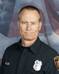
Thirty-six year Los Angeles Fire Department veteran Glenn Allen, 61, died after a ceiling collapse inside the custom-built Viewsite Drive home during the February 2011 fire. 
A nearly year-long investigation by Los Angeles City Fire Department's arson investigation team, the Los Angeles Police Department's Robbery-Homicide Division and other agencies led to an involuntary manslaughter charge against Gerhard Becker, 49, whose house was to be featured in the show "Germany's Next Top Model." The investigation concluded the fire was started by a "negligently installed" fireplace inside the home that was designed for outdoor use.
Becker, who designed and oversaw the home's construction, faces a maximum sentence of four years in prison. The criminal case against him has been in the pre-trial stages, and the results of Friday's  plea hearing in a downtown Los Angeles courtroom could allow Becker to avoid a trial.
In a post on the LAFD web site, a department spokesman said, "Belief that the court is leaning toward a more lenient sentence has brought frustration to many members of the Fire Service, and stirred strong sentiment in the community - especially among those who Glenn Allen proudly served."
Eleven other firefighters were injured in the collapse, some pinned by part of the ceiling. Investigators determined that the attic of the home filled with water, saturating the ceiling, after fire burned a plastic sprinkler system.
An LAFD captain testified at a court hearing in Becker's case that he heard "a loud bang" and felt the weight of the ceiling on him. The bang was followed by an "eerie silence" in the house.
Colleagues used chainsaws as they attempted to pull Allen from the debris. He was transported to a hospital, where he died days later.
Becker, a German national, and another person in the house escaped without injury. Becker was arrested a year later at Los Angeles International Airport after a flight from Spain.
Becker will be deported to Germany when he finishes his prison sentence.
Source: - http://www.nbclosangeles.com/news/local/Firefighter-Death-LAFD-Glenn-Allen-Architect-Manslaughter-Gerhard-Becker-238588171.html

---------------------------------------------

Thursday, January 2, 2014

LAFD Firefighters To Pack Courtroom En mass In Firefighter Death Plea Bargain Case #CaFire #Calaw

Update: German Architect Pleads No Contest in Firefighter's DeathA year-long investigation concluded a "negligently installed" fireplace caused the fire and ceiling collapse that killed a 36-year LAFD veteran
 LAFD Firefighter/Paramedic Glenn Allen, Trapped And Killed In Structure Fire
LOS ANGELES - A man charged with manslaughter for the death of a Los Angeles Firefighter will face a downtown courtroom packed with his colleagues on Friday, January 3, 2013. 

The off-duty members of the Los Angeles Fire Department will gather respectfully in honor of Firefighter/Paramedic Glenn Allen, who died following a February 16, 2011 structure fire that involved a custom-built home on Viewsite Drive in the Hollywood Hills.

During fire suppression efforts, a ceiling collapsed, causing injury to 11 firefighters and leading to the death of Allen, a 36 year veteran of the Department.

Following the fire, an investigation ensued to determine if there was criminal culpability for Glenn Allen's death. As a result of that investigation, which involved the LAFD Arson/Counter-Terrorism Section, LAPD Robbery Homicide Division, and the Bureau of Alcohol, Tobacco, and Firearms (ATF), an arrest was made. Gerhard Becker, the owner/architect of home, was ultimately charged with one count of manslaughter.

The criminal case against Becker has been in the pre-trial stages. Becker has now indicated to the court that he wishes to enter a plea that would cause him to be sentenced for his crime without having to face trial. As such, his plea and sentencing for case #BA393940 has been scheduled before Judge Robert Perry:

Friday, January 3, 2014
8:30AM
Criminal Courts Building, Department 104
210 West Temple Street
Los Angeles, CA 90012

The District Attorney's Office is asking for the maximum term of four years in state prison. Belief that the court is leaning toward a more lenient sentence has brought frustration to many members of the Fire Service, and stirred strong sentiment in the community - especially among those who Glenn Allen proudly served.

NOTE: Results of the hearing will be posted via an updated article on Friday afternoon at the LAFD News & Information blog For complete information, a photo and updates, kindly visit: http://lafd.blogspot.com/2014/01/man-charged-with-death-of-los-angeles.html


Source: Brian Humphrey
Firefighter/Specialist - Public Service Officer
Emergency Public Information (EPI) Center
Los Angeles Fire Department

"Serving with Courage, Integrity and Pride"

---------------------------------------------

CA-ORC-Holy 2 Acres North Side Of Holy Jim Canyon. Road closure at Live Oak and Trabuco Creek.

CA-ORC-Holy Orange County, CA 
Multiple starts Holy Jim Canyon, Santiago

Update 1/4/14 0830 hrs: Small brush fires burning in California's Holy Jim Canyon that injured one person and destroyed two cabins were contained early Thursday, authorities said.
Three fires broke out in the canyon near Trabuco Hills Wednesday evening, KTLA-TV, Los Angeles, reported.
About 100 firefighters worked to quell the flames.
Cabins in the area were evacuated, although a man staying in one of the burned-out cabins suffered burns on his arms, officials said.
The cause of the fires is under investigation.
Evacuations: Evacuating Holy Jim Canyon
Road Closures: Road closure at Live Oak and Trabuco Creek.

IA Start: 1/3/14 1830 hrs
Location: North Side Of Holy Jim Canyon, Orange County
GPS: 33.6758834,-117.5189705
Acres: 1 1/2 
ROS: Moderate 
ROC: 3 fires 1/2 acre each. 
Structure Threats: Yes Structures involved - 2 cabins. 
Special Hazards: Access limited, water supply limited, large 'dead looking' trees near structures Resources: 4 strike teams 
Radio Frequencies: OCFA 151.085
Weather Info: 
Other Comments: Major Televised Fire

---------------------------------------------

Twitter Buttons

****REMINDER**** Every fire has the ability to be catastrophic. The wildland fire management environment has profoundly changed. Growing numbers of communities, across the nation, are experiencing longer fire seasons; more frequent, bigger, and more severe, fires are a real threat. Be careful with all campfires and equipment.

"I am a firm believer in the people. If given the truth, they can be depended upon to meet any national crisis. The great point is to bring them the real facts, and beer." --Abraham Lincoln

View blog top tags
---------------------
CLICK HERE TO GO BACK TO TOP OF CALIFORNIA FIRE NEWS HOME PAGE

Subscribe via email to California Fire News - Keep track of Cal Fire News

Enter your email address:

Delivered by FeedBurner