Thursday, January 3, 2008

CHINA - Major Structure Fire - Three LODD's


12-Story Bldg. Fully Involved In China

CHINA - During search and rescue operations in a fully involved 12 story commercial building three Fire fighters have died during the SAR operations and a fourth is injured.

The building is loaded with 2,000 vendors selling clothes, cosmetics, toys and various kinds of commodities from the basement up to its fourth floor. The fifth to 12th floors were used as offices.

After pulling completely off direct interior attack after the tragic deaths, Officials are now claiming control but looking at the available photographs the building appeared to be still ripping with visible flames, heavy smoke, and a quite impressive column (little pre Olympics propaganda?).

The caption under the above picture

"Smoke is seen as the fire was under control at a wholesale market building in Urumqi, capital of northwest China's Xinjiang Uygur Autonomous Region, Jan. 3, 2008. A strong fire and heavy smoke engulfed the 12-storey wholesale market building in Xinjiang Uygur Autonomous Region Wednesday night. (Xinhua Photo)"

Reading between the lines after attempts to stop extension of the fire to an adjoining 20 story hotel failed it appears they are successfully containing the fire to the two fully involved buildings now and are allowing the two buildings to safely burn themselves out.

Firegeezer is keeping track of the story
Reuters has a good VIDEO REPORT.
Xinhua state news agency has the latest STORY.

Wednesday, January 2, 2008

NWS: Special Weather Statement -145 MPH winds

The National Weather service released a "Special Weather Statement" late today with alarming warnings for the High Sierra with Blizzard warnings and high wind warnings involving 145 MPH winds on the Eastern Slopes of the High Sierra and into Nevada.

Highlights of the Statement -
HIGH WIND WARNING FROM 4 AM TO 6 PM FRIDAY FOR WESTERN NEVADA ALONG AND SOUTH OF INTERSTATE 80.
Blizzard warning North of I 80 Sierra Nevada's- 4 am Friday to 4 am Saturday
Blizzard warning South of I 80 Sierra Nevada's- 4 am Friday to 10 am Saturday including Lake Tahoe and Mono County.


THIS STORM WILL PRODUCE STRONG AND POTENTIALLY DAMAGING WINDS ON FRIDAY. THESE WINDS ARE FORECAST TO COMBINE WITH HEAVY SNOW TO PRODUCE WIDESPREAD BLIZZARD CONDITIONS IN THE SIERRA. STATE AND LOCAL EMERGENCY MANAGERS ARE WORKING WITH THE NATIONAL WEATHER SERVICE AND ARE IN THE PROCESS OF PREPARING FOR EMERGENCY RESPONSE

WINDS WILL INCREASE TO 80 TO 100 MPH WITH GUSTS NEAR 145 MPH LATE THURSDAY NIGHT AND CONTINUE THROUGH FRIDAY AFTERNOON. FOR THE EASTERN SIERRA SLOPES AND WESTERN NEVADA

Read the whole thing here
http://www.edis.ca.gov/
Message:KREV4009225039 from KREV@nwws.oes.ca.gov

Got rain? - SF Bay Area get prepared now!

SF Bay area (CAL FIRE NEWS) - The San Francisco Bay Area wild lands that burned in wild fires last summer could be hit hard with this incoming weather event.

The incoming rain is expected to begin noon Thursday and will taper off Sunday. This weather event is predicted to bring very heavy rains and winds gusting over 50 Mph

Areas burned this year in the 47,760 acre Lick Fire which hit Henry Coe State park particularly hard this summer could see 2 inches of rain in a matter of hours according to the latest weather reports.
and two years ago the 34, 217 acre Canyon Fire which burned northeast of the Lick Fire perimeter in Del Puerto Canyon did not see much rain last year and new growth vegetation is sparse which could equal land and rock slides.

Another trouble spot could be near Stevens Creek in last years Stevens Fire area which could receive tremendous amounts of rainfall.

If you live in area impacted by wild fires last year or has a previous history of problems during heavy rains get prepared now!

You know what you need better than anyone such as your medications, extra eye glasses, etc.
Are you also ready to shelter in place and or protect your property? maybe some bottled water, MRE's, flashlights, tarps, timber and sandbags?
When thinking about evacuation plans remember your pets in the plan, transportation, water, food, shelter just like you.

Make your plan and backup plan now - Stock your supplies and hold on this could be a bad one.

Marin: Prescribed burning to begin

MARIN COUNTY - The Marin County Fire Department will burn piles of vegetation in several county locations over the next several months, a county-approved measure to keep fires from spreading to homes, fire officials said Monday.

Tamalpais Fire Crew members have been cutting and piling vegetation along key county ridgelines since June, hoping to reduce brush accumulation that could cause or help spread fires, fire officials said.

The brush piles are located at Luiz Fire Road above San Domenico School in Sleepy Hollow; Chicken Shack Fire Road between Pacheco Valley and Indian Valley in Novato; and Blithedale Ridge Fire Road above Mill Valley.

The burning will run from 9:30 a.m. to 4 p.m. Tuesday through Friday and only on permitted burn days, fire officials said.

The Marin County Board of Supervisors approved of the burning in 2005.

Tuesday, January 1, 2008

2007 Southern California fire season runs out of time

QUICK LOOK AT THE RECORD SETTING 2007 CALIFORNIA WILD LAND FIRE SEASON

CAL FIRE NEWS - Apparently the Southern California fire season truly never ends, With some seasonal wildland firefighter positions extended right into 2008, Winter aircraft maintenance deferred because the planes are still flying, Weather watches and Red Flag warnings daily, Extra crews and prepositioned strike teams away from home and working Thanksgiving, Christmas and New Years shifts.

The Zaca2 fire is still not officially controlled with small inaccessible interior burns called "Smokes" still burning inside the perimeter fire officials are waiting for the winter rains to finish the job.

The fuels are still very dry, with the very few rains and dry winds always quickly re-drying the fuel.
From San Diego to Los Padres National Forest the fire season tried to slow down but never really stopped.

First came the spectacular Catalina Island Fire named the Island Fire May 10, which started just after the lunch hour and burned 4,750 acres in about five days, Destroying one home and six other buildings.

The next real news maker California wild land fire in 2007 was the Angora Fire 3,100 acres June 24th and ignited in the South Lake Tahoe area burning right up to the edge of downtown and the local high school track, Destroying 254 residences, 75 commercial structures and out buildings destroyed, 35 homes were damaged.

Then July came in with ferocity with the monster called the ZACA fire started by a couple hardworking ranch hands with a angle grinder CAL FIRE chased it off the SRA lands while protecting the structures to the southwest in the Wildland Urban interface and then the winds turned north and it went northeast right into the Los Padres National Forest.

The very rugged and mostly inaccessible Los Padres wilderness areas are Federal responsibility thereby allowing CAL FIRE to hand the fire off to United States Forest Service(USFS) by default.

Almost at the same time a series of large lighting storms passed over Northern California for a few days and ignited a whole series of fires in the far North state some of the fires in the remote wilderness areas were managed as WUF fires(Wildland Fire Use) and allowed to burn with supervision, other fires developed and merged together and were managed as a single fire called a fire complex.

One of the fire complexes was named the Inyo Complex Fire 35,176 acres started on July 6th it burned deep in the Inyo National Forest and was very stubborn, At the same time the Antelope Complex July 5th was burning in the Plumas National Forest and another 22,902 acres of heavy timber was consumed before control.
July 10 brought California the Elk Complex Fire in the Kalamath National Forest two months later when it was 90% contained at 17,684 acres in the Klamath river drainage it was allowed to burn it self out.

The first significant Malibu Canyon fire in 2007 started on July 7th and burned 815 acres before control, a few days later the China Back Complex ignited due to severe lightning from thunderstorms on July 9th and burned 2,906 acres 12 miles west of Yreka, Calif in Klamath river drainage. The same storm front also started the Fletcher fire and burned 8,121 acres 2,207 acres on the Modoc National Forest land and 4,399 acres of private land and of those acres, 1,515 acres were in Oregon.

Also because of the lightning the Colby fire 260 acres snaked around the Lassen National Forest and the Seven Eleven Complex Fire July 11th burned in the Six Rivers National Forest adding another 190 acres of heavy timber burned.

The Tar Fire August 10th in Fresno County was declared controlled on August 17 at 5,644 acres.

The ZACA Fire was still burning further south and resisting containment in the inaccessible terrain was nearing 100,000 acres with no containment date in sight and now renamed the ZACA 2 when it threatened State responsibility lands again and a unified command was created with the corresponding huge amount of resources thrown into the battle.

At one point 110 private contract water tenders were ferrying water into the rugged, dry wilderness and during the height of the battle a courageous stand by the crews was made on state highway 33 during a wind event when firefighters held the fire to the west of the highway in area called the switchbacks chasing slop overs and keeping the fire from consuming another 100,000 acres of the Dick Smith wilderness.

August had the Nor Cal fire crews on the west face of the Sierras busy with the Snow, 80, and Italian fires all held to about a 100 acres in Timber and Chaparal.
An exception was the Lazy Fire up in the Shasta-Trinity National Forest which went to 599 acres and the Wallow Fire at 1440 acres, Started on August 27th the lightning caused Grouse Fire was holding a week later at 1,022 acres.

Near the end of August in the Klamath National Forest they began fighting the Cherry Fire held to 95 acres and out on the coast the Quien Fire was being contained at 486 acres by CAL FIRE San Benito-Monterey Unit.
That same day the Stevens Fire broke out in the Stevens Creek drainage in a very rugged, Oak and scrub land but populated urban interface filled with multi-million dollar homes, the CAL FIRE SCU Unit hit the fire hard with large wildland fire resource response including calling Tanker 910(DC-10) to make a few 12,000 gallon drops on the fire and stretching over 50,000 feet of line across the terrain before containment at 151 acres.

September started out right away on the first day of the month with The Butler fire in the San Bernardino National Forest west of Big Bear Lake which was contained quickly and held to 85 acres, The next day the North Fire 2,200 acres broke out in the Angeles National Forest.
and again on the next day September 2nd the Lick Fire started by a resident's burn barrel began burning into the rugged and dry Henry Coe State Park which had not seen a fire or public vehicle access in forty years and was finally contained at 47,760 acres becoming one of Santa Clara Counties largest historical fires.
Also on September 3rd the human caused Moonlight Fire started, Becoming plume driven it would burn 64,997 acres before containment and the Mariposa Fire another 176 acres.

September 10th the Colina Fire was fought with a unified command, CAL FIRE Riverside Unit / Riverside County Fire departments held it to 430 acres of vegetation burned, Two days later the Pine Fire in the Cleveland National Forest consumed 2,170 acres South of Pine Valley.
Two more days and the Butler 2 fire 14, 039 acres started in the San Bernardino National Forest North of Big Bear.
Then the Angel Fire 837 acres near Julian two days later.

Fuels were heating up and drying out to record low moisture levels never before recorded in California History.

Then October arrived bringing in the first Santa Ana winds of the year and perfect Firestorm conditions. Numerous vegetation fires were caught and stopped early all over the State of California during the first weeks of October with Cal FIRE sending large full wild land responses including all aircraft on the first bell and sizing them up later.
Then during the last week of October Southern California exploded in fire and soon over 500,000 people would be evacuated from the Southern California Wildland firestorms.

Beginning with the Ranch Fire 58,401 acres deep in the Angeles National Forest lands of Los Angeles County started on October 20th and which would not be 100% controlled until the middle of December. Then the next day San Diego County Ranch lands ignited in a firestorm called the Harris Fire 90,440 acres started by illegal migrants in an area just above the Mexican border Eight people were killed by the Harris Wildfire in San Diego County, which also seriously injured four firefighters and a teenage boy and consumed hundreds of homes in the rural communities along the U.S.-Mexico border east of San Diego.
That same day brought us the Canyon Fire and the Sedgewick Fire 710 acres, McCoy Fire 353 acres, Roca Fire 270 acres, October Fire 20 acres, Nightsky Fire 35 acres, Buckweed Fire 38,000 acres, Santiago Fire 28,400 acres in Orange County.

The rash of fires breaking out continued the next day with the Witch Fire 197,990 acres before she was done and Walker Fire 160 acres in San Bernardino County, The Rosa Fire 411 acres in Riverside County, Magic Fire 2,824 acres in Los Angeles County, Cajon Fire 250 acres and the Grass Valley Fire 1,247 acres burning in the San Bernardino National Forest and the Coronado Hills Fire 250 acres and Rice Fire 9,472 acres started in San Diego county.

A week later the Slide Fire 12,759 acres.

The new starts continued on the 23rd with the Poomacha Fire 49,410 acres, and Ammo Fire 21,004 acres breaking out in San Diego County.

November delivered the arson caused Malibu canyon fire called the Corral Fire 4,901 acres burned in a dense wildland urban interface chasing 14,000 Residents from their homes and destroying 53 residences this fire was apparently caused by a campfire and carelessness combined with alcohol during Red Flag conditions.

December left us in Constant Red Flag conditions, The ZACA 2 Fire perimeter held at 240,207 acres burned and never did receive any appreciable rain and it was the end of a Historic California wild land fire year.

Welcome to California Wildland Fire season 2008

Fire Weather: Red Flags extended through Wednesday

Most of Southern California remains under Red Flag Fire weather alerts through today and into Wednesday afternoon.
A RED FLAG WARNING NOW IN EFFECT UNTIL 2 PM PST WEDNESDAY Actual/Immediate/Severe/Observed
ORANGE COUNTY COASTAL AREAS-SAN BERNARDINO AND RIVERSIDE COUNTY VALLEYS-THE INLAND EMPIRE-SAN DIEGO COUNTY INLAND VALLEYS-SAN BERNARDINO COUNTY MOUNTAINS-INCLUDING THE MOUNTAIN TOP AND FRONT COUNTRY RANGER DISTRICTS OFTHE SAN BERNARDINO NATIONAL FOREST-RIVERSIDE COUNTY MOUNTAINS-INCLUDING THE SAN JACINTO RANGER DISTRICT OF THE SAN BERNARDINONATIONAL FOREST-SANTA ANA MOUNTAINS-INCLUDING THE TRABUCO RANGER DISTRICT OF THE CLEVELAND NATIONALFOREST-SAN DIEGO COUNTY MOUNTAINS-INCLUDING THE PALOMAR AND DESCANSO RANGER DISTRICTS OF THECLEVELAND NATIONAL FOREST-
Alert sent at 14:15 PST on 2008-01-01
A RED FLAG WARNING NOW IN EFFECT UNTIL 4 PM PST WEDNESDAY Actual/Immediate/Severe/Observed
LOS ANGELES COUNTY VALLEYS-
Alert sent at 13:32 PST on 2008-01-01
A RED FLAG WARNING NOW IN EFFECT UNTIL 4 PM PST WEDNESDAY FOR GUSTY WINDS AND VERY DRY CONDITIONS Actual/Immediate/Severe/Observed
LOS ANGELES COUNTY COAST-
Alert sent at 13:32 PST on 2008-01-01
A RED FLAG WARNING NOW IN EFFECT UNTIL 4 PM PST WEDNESDAY FOR GUSTY WINDS AND LOW HUMIDITIES Actual/Immediate/Severe/Observed
VENTURA COUNTY COAST-
Alert sent at 13:32 PST on 2008-01-01
A RED FLAG WARNING NOW IN EFFECT UNTIL 4 PM PST WEDNESDAY FOR GUST WINDS AND LOW HUMIDITIES Actual/Immediate/Severe/Observed
SANTA MONICA MOUNTAINS RECREATIONAL AREA-
Alert sent at 13:32 PST on 2008-01-01
A RED FLAG WARNING NOW IN EFFECT UNTIL 4 PM PST WEDNESDAY FOR GUSTY WINDS AND LOW HUMIDITIES Actual/Immediate/Severe/Observed
VENTURA COUNTY INTERIOR VALLEYS-VENTURA COUNTY COASTAL VALLEYS-
Alert sent at 13:32 PST on 2008-01-01
A RED FLAG WARNING NOW IN EFFECT UNTIL 4 PM PST WEDNESDAY FOR GUSTY WINDS AND LOW HUMIDITIES Actual/Immediate/Severe/Observed
SANTA CLARITA VALLEY-
Alert sent at 13:32 PST on 2008-01-01
A RED FLAG WARNING NOW IN EFFECT UNTIL 4 PM PST WEDNESDAY FOR GUSTY WINDS AND LOW HUMIDITIES Actual/Immediate/Severe/Observed
VENTURA COUNTY MOUNTAINS / LOS PADRES NATIONAL FOREST-LOS ANGELES COUNTY MOUNTAINS / ANGELES NATIONAL FOREST-
Alert sent at 13:32 PST on 2008-01-01
A RED FLAG WARNING HAS BEEN ISSUED FOR THE MOUNTAINS OF SANTA BARBARA AND SAN LUIS OBISPO COUNTIES AND THE CUYAMA VALLEY FOR LOCALLY GUSTY WINDS AND LOW HUMIDITIES FROM THIS AFTERNOON THROUGH 4 PM WEDNESDAY Actual/Immediate/Severe/Observed
CUYAMA VALLEY-SAN LUIS OBISPO COUNTY MOUNTAINS / LOS PADRES NATIONAL FOREST-SANTA BARBARA COUNTY MOUNTAINS / LOS PADRES NATIONAL FOREST-
Cancel sent at 13:32 PST on 2008-01-01

FEMA: 2007 California Wild Fire assistance deadline

Disaster Assistance Application Deadline Quickly Approaching

Release Date: December 28, 2007
Release Number: 1731-084

» More Information on California Wildfires

PASADENA, Calif. -- There are less than two weeks left to apply for federal and state disaster assistance from the Federal Emergency Management Agency (FEMA), the U.S. Small Business Administration (SBA) and the State of California. The deadline to apply for federal and state disaster assistance is at 6 p.m. on Wednesday, Jan. 9, 2008.

Individual assistance continues to be provided for residents with property damages from the wildfires. Here is a summary of disaster assistance funding:

  • $60 million - Approved (SBA) loans to homeowners, renters and business owners.
  • $8.7 million - Housing assistance grants from FEMA for rental expenses, home repair or replacement.
  • $3.5 million - Assistance with other needs from FEMA and the State of California for losses and damage to personal property, vehicle repair or replacement, moving expenses and other disaster-related costs.
  • $1.7 million - Approved California State Supplemental Grants from the California Department of Social Services for those who have received the maximum grants for housing and other needs from FEMA and the state.
  • $185,211 in federal Disaster Unemployment Assistance funds has been disbursed by the California Employment Development Department to individuals unemployed by the wildfires.

During the holiday period, the registration line at 1-800-621-FEMA (3362) or TTY 1-800-462-7585 will be closed on Jan. 1. Other than this holiday closure date, the registration line will be open from 8 a.m. to 6 p.m., Monday through Saturday until close of business on Jan. 9, 2008. Those who have registered are reminded to go online at: www.fema.gov/assistance/process/update_assistance.shtm or call FEMA to report any changes in personal or insurance information and to check the status of their application.

Beyond the dollars provided to Southern California residents, much individualized service is involved in wildfire recovery.

  • 18,685 Californians have registered for state and federal disaster assistance.
  • 15,003 FEMA registrants visited assistance centers seeking disaster recovery help and mitigation information in English, Spanish, Chinese, Vietnamese, French and other languages. All disaster recovery centers are now closed.
  • 8,175 FEMA inspections have been completed in disaster-designated counties. These inspections of wildfire-damaged structures are a prerequisite for property owners to qualify for federal and state grants and low-interest loans to repair, replace or rebuild.

FEMA's community relations specialists walk disaster neighborhoods to offer recovery information and assistance. To date they have spoken with:

19,457 Residents
6,910 Businesses
1,050* Faith-Based Organizations
275 Community-Based Organizations
284 Local Governments
499 Local Agencies
210 Schools
(*Revised from 12/22 weekly summary release, NR 83, published as 1,079)

Crisis counseling for wildfire victims is available. Those who may be feeling overwhelmed as a result of the wildfires or need disaster-related counseling may call the hotline number for their county:

Los Angeles 1-800-854-7771
Orange 1-866-830-6011
Riverside 1-800-706-7500
San Bernardino 1-888-743-1478
San Diego 1-800-479-3339
Santa Barbara 1-888-868-1649
Ventura 1-800-671-0887

People living or working in the seven disaster-designated counties whose jobs were affected by California wildfires may apply for Disaster Unemployment Assistance (DUA) from the California State Employment Development Department until Jan. 9, 2008.

The fastest and easiest method for individuals to file claims for DUA benefits is online at www.edd.ca.gov/fleclaim.htm. Claimants can also file by telephone:

English 1-800-300-5616
Spanish 1-800-326-8937
Cantonese 1-800-547-3506
Mandarin 1-866-303-0706
Vietnamese 1-800-547-2058
TTY (non-voice) 1-800-815-9387

The California State Bar has a legal assistance hotline at 1-866-636-9041. Wildfire victims can call the line with disaster-related basic legal questions, such as replacing lost documents, housing-landlord-tenant disputes, and insurance issues.

Public assistance grants will be made available on a cost share basis to state, county and local governments and qualified non-profits for eligible emergency work such as debris removal and reimbursement for protective measures, plus repairs to roads, public utilities, public buildings, and public parks.

FEMA coordinates the federal government's role in preparing for, preventing, mitigating the effects of, responding to, and recovering from all domestic disasters, whether natural or man-made, including acts of terror.

Source: FEMA News release

LAFD: New Fire Station 62 in Mar Vista

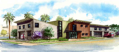
Grand Opening of New Fire Station 62 in Mar Vista

Artists Concept of new LAFD Station 62 The men and women of the Los Angeles Fire Department welcome you to join Mayor Antonio Villaraigosa, Councilmember Bill Rosendahl, Fire Commissioners, Fire Chief Douglas Barry, City Engineer Gary Lee Moore and civic and community leaders at the public dedication and grand opening of LAFD's newest Neighborhood Fire Station in Mar Vista.

Saturday, January 5, 2008
10:00 AM
Grand Opening of New Fire Station 62
11970 Venice Boulevard
Los Angeles, CA 90066


Following Saturday's brief dedication ceremony, there will be food and fun as well as a chance to tour Southern California's newest Fire Station. All members of the community are welcome at this family-themed public event.

Check out the rest of the story, Directions to the new station, and the history of the original Station 62 in Mar Vista at LAFD Blog

EDIS: More Red Flags for So Cal announced

RED FLAG WARNING REMAINS IN EFFECT UNTIL 6 PM PST THIS AFTERNOON Actual/Immediate/Severe/Observed
LOS ANGELES COUNTY VALLEYS-
Update sent at 09:56 PST on 2008-01-01
RED FLAG WARNING REMAINS IN EFFECT UNTIL 6 PM PST THIS AFTERNOON Actual/Immediate/Severe/Observed
LOS ANGELES COUNTY COAST-
Update sent at 09:56 PST on 2008-01-01
RED FLAG WARNING REMAINS IN EFFECT UNTIL 6 PM PST THIS AFTERNOON Actual/Immediate/Severe/Observed
VENTURA COUNTY COAST-
Update sent at 09:56 PST on 2008-01-01
RED FLAG WARNING REMAINS IN EFFECT UNTIL 6 PM PST THIS AFTERNOON Actual/Immediate/Severe/Observed
SANTA MONICA MOUNTAINS RECREATIONAL AREA-
Update sent at 09:56 PST on 2008-01-01
RED FLAG WARNING REMAINS IN EFFECT UNTIL 6 PM PST THIS AFTERNOON Actual/Immediate/Severe/Observed
VENTURA COUNTY INTERIOR VALLEYS-VENTURA COUNTY COASTAL VALLEYS-
Update sent at 09:56 PST on 2008-01-01
RED FLAG WARNING REMAINS IN EFFECT UNTIL 6 PM PST THIS AFTERNOON Actual/Immediate/Severe/Observed
SANTA CLARITA VALLEY-
Update sent at 09:56 PST on 2008-01-01
A RED FLAG WARNINGREMAINS IN EFFECT THROUGH TUESDAY AFTERNOON FOR MUCH OF LOS ANGELES AND VENTURA COUNTIES DUE TO GUSTY NORTHEAST WINDS AND LOW HUMIDITIES Actual/Immediate/Severe/Observed
VENTURA COUNTY MOUNTAINS / LOS PADRES NATIONAL FOREST-LOS ANGELES COUNTY MOUNTAINS / ANGELES NATIONAL FOREST-
Update sent at 09:56 PST on 2008-01-01

Happy New Year with Red Flags for SoCal

RED FLAG WARNING REMAINS IN EFFECT UNTIL 5 PM PST THIS AFTERNOON

A COMBINATION OF STRONG WINDS... LOW RELATIVE HUMIDITY... AND WARM TEMPERATURES WILL CREATE EXPLOSIVE FIRE GROWTH POTENTIAL.

A RED FLAG WARNING MEANS THAT CRITICAL FIRE WEATHER CONDITIONS ARE EITHER OCCURRING NOW...OR WILL SHORTLY

Areas affected: San Bernardino and Riverside County Mountains and Valleys including the San Bernardino National Forest, Orange County Coastal areas, San Diego County and Inland Empire valleys and mountains including Cleavland National Forest lands, Santa Ana Mountains.

Winds:
Winds from the Northeast to East gusting between 35 and 60 Mph are likely to continue through and below wind prone mountain passes and canyons.
The winds should diminish this afternoon and become more localized over San Bernardino County and Orange County this afternoon, and over Riverside and San Diego this evening
Temperatures: Temeratures will be 5 to 10 degrees warmer during this weather event
Humidity:
Relative humidity will drop below 10 percent in most locations

Ref: EDIS

Twitter Buttons

****REMINDER**** Every fire has the ability to be catastrophic. The wildland fire management environment has profoundly changed. Growing numbers of communities, across the nation, are experiencing longer fire seasons; more frequent, bigger, and more severe, fires are a real threat. Be careful with all campfires and equipment.

"I am a firm believer in the people. If given the truth, they can be depended upon to meet any national crisis. The great point is to bring them the real facts, and beer." --Abraham Lincoln

View blog top tags
---------------------
CLICK HERE TO GO BACK TO TOP OF CALIFORNIA FIRE NEWS HOME PAGE

Subscribe via email to California Fire News - Keep track of Cal Fire News

Enter your email address:

Delivered by FeedBurner