Showing posts with label fire map. Show all posts

Thursday, September 18, 2014

Quick Look Current California Wildfires Today News and Notes (MAP)

Quick Look Current California Wildfires Today (MAP)


View California Fire Map in a larger map


California Fire News and Notes:

  • No Current Fire Weather Watches / Warnings
  • Authorities Announced today that Wayne Allen Huntsman has been arrested for alleged deliberate arson in starting the
KING FIRE MEDIA BRIEFING 9/18/14 REGARDING ARSON ARREST
OSCC - SOUTH OPS

June Fire, CA-INF-001351, Mono County, June Lake Parking Lot, FRA
65 acres, 50% Contained
SoCal Type 2 team (Wakoski) assumed command.
Unified command with June Lake Fire Protection District, USFS-INF,
CHP, and Mono County Sheriff
Evacuations: 250 residences remain threatened with 150 people evacuated and 100 people in temporary shelters.
  • June mountain ski resort and the Owens River head water wilderness continues to be threatened. 
  • Power remains out to June Lake area as fire damaged transmission lines. Also impacted cell tower infrastructure.
  • WX: Temp 57°, RH 47%, Wind NW 5 mph.
  • For today’s operational period, Complete hose lay and begin mop up operations with Commitment of Forest Service air and ground resources.

Courtney Fire, CA-MMU-016429, Madera County
320 acres, 80% Contained.

Type 1 IC (Drozen)
Notes: All evacuations have been lifted for the community of Bass Lake Heights.
  • Soft road closure in place for residents only on Rd 426 between 
  • Summit Rd & Rd 223
  • WX: Temp 72°, RH 66%, winds NW 10 mph 
  • Continued mop up. 
  • Commitment of Forest Service air and ground resources.
Silverado Fire, CA-CNF-2873, Orange County, FRA968 acres, 97% contained.
SO CAL Type 2 IMT (Garwood)
Notes:

  • The Silverado will transition back to the Forest this morning
  • The Close-out for Garwood’s IMT is at 0930 today.
  • Fire will be unstaffed during nighttime hours.
  • WX: Temp 71°, RH 68%, Wind S 3 mph.
  • Commitment of Forest Service air and ground resources.
Meadow Fire, CA-YNP-00101, Mariposa County
4,772 acres, 80% contained.
Notes:

  • Type 3 IC (Speilman/ Loomis Trainee)
  • Ground resources continue to patrol fire.
  • Temp 67°, RH 54%, wind N 4 mph.
  • Commitment of Forest Service air and ground resources.

ONCC - NORTH OPS

Track 17 FireCA-SWR Track 17 Fire
500 acres burning in grass and brush, 75% contained.
Update 1230: 395 acres, 80% contained. Reduction in acreage due to more accurate mapping.
July ComplexCA-KNF July Complex, Klamath National Forest
50,042 acres, 98% contained.
Notes: Creeping and smoldering.
Happy Camp ComplexCA-KNF Happy Camp Complex: 125,788 acres, 68% contained. 
Notes:
  • Increased moisture resulted in decreased spread overnight.
  • Creeping and smoldering.
  • Precipitation occured over the fire area.

Boles FireCA-SKU Boles Fire
375 acres, 60% contained. 
Notes: Fire continued to smolder. Strong winds continue to make any smoldering material within 500' of the line a danger to renewed fire spread.

Irene Fire: CA-ENF Irene Fire
85 acres in brush, 0% contained. 
Notes: Main emphasis is to locate spot fires and mop-up the north side of the fire as it is holding most of the heat.
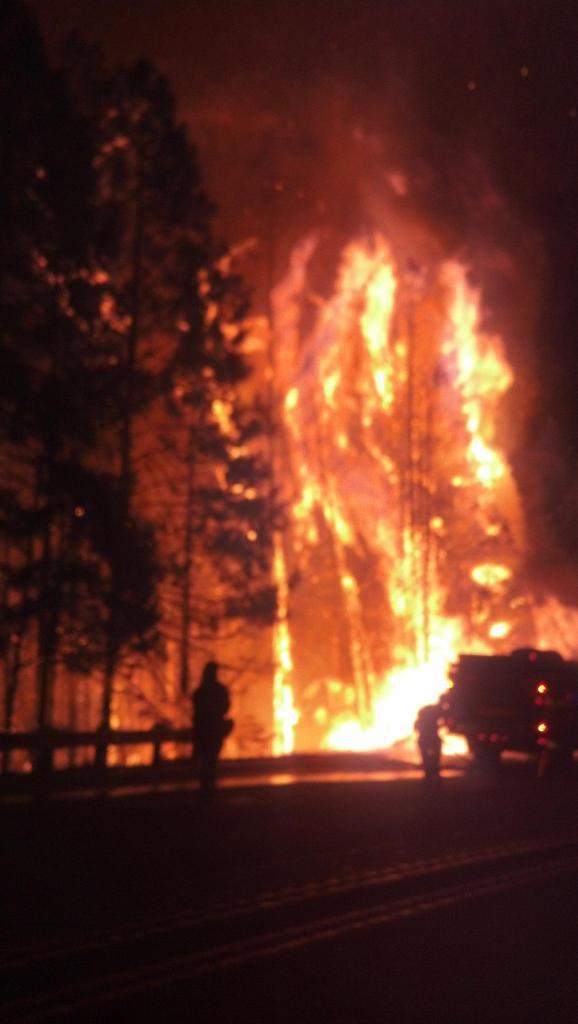
King FireCA-ENF King Fire
70,944 acres, 5% contained. 
Notes: The fire remained active overnight. Incident personnel determined that the fire made a run of over ten miles north between 1600 yesterday and 0600 this morning.

---------------------------------------------

Wednesday, September 17, 2014

CA-ENF- KING 27,930 acres 5%, MAPS / EVACUATIONS ONGOING / UPDATE

KING FIRE CA-ENF- KING

Update 1900: 27,930 acres 5% This afternoon fire behavior became extreme with plume domination, crown runs and long range spotting.
On scene photos from CHP Officer Mike Powers
38.782 latitude, -120.604 longitude 

Map data ©2014 Google

Map
Satellite
20 km 
CA-ENF- KING GOOGLE MAP


King Fire Hotspot map
 King Fire Incident Overview

The King Fire is currently located in the canyon of the South Fork of the American River north of the community of Pollock Pines.

Special Announcements: Public Meeting - Wednesday at 6:30 PM. Georgetown Elementary School at 6530 Wentworth Springs Road, Georgetown, CA 95634.

Evacuations: 
Evacuations: 2,155 people
For a full list of the individual roads go to the Sheriff's blog at http://http://pio.edso.org/.[NEW] Shelter Location: Moved to the Camino Seventh-day Adventist Church at 3520 Carson Road, Camino, CA 95709.

Note- The mandatory closure to all residences south of Highway 50 between Fresh Pond and Riverton has been changed to a voluntary advisory.

Mandatory Evacuation Orders are still in effect for the following areas:

Still under Mandatory Evacuation: Forebay Road (north of Moon Lane), Homestead, Randolph Canyon Road

Crystal Basin - Hwy 50 east of Fresh Pond to Icehouse, north on Icehouse Road to Wentworth Springs, west to just above Quintette, to include campgrounds and businesses. Union Valley Reservoir area, Yellow Jacket Campground, Wolf Creek Campground, Stumpy Meadows Campground, Fashoda Campground, Big Hill Lookout Road, Big Hill Road, Blodgett Forest Road, Bridle Path Way, Forest Road, Frontier Road, Helix Flat Ave, Icehouse Road (west side), Jones Fork Power House Road, Middle Loop Road, Mosquito Road, Onion Valley Road, Outer Limits Lane, Little Silver Road, Loop road, Peavine Point Road, Peavine ridge Road, Plum Creek Road, Piolet Creek Road, Robbs Peak Road, Sand Mountain Road, SMUDEA (permittee site), Spring Road, Sunset Drive, Tricometric Trail, Wentworth Springs (south side, east of Pilot Creek Road), and 11 Pines Road.

The entire community of Swansboro, north of the South Fork of the American River between Brushy Creek and Rock Creek.

All roads north of Pony Express Trail from Forebay Road east through Bullion Bend. White Meadows Road and Spring Valley Road.

Voluntary Evacuation Advisories - All evacuations have been lifted for the communities of Gold Ridge and Lakewood Spring. For residences south of Highway 50 between Fresh Pond and Riverton the advisory has been downgraded to voluntary. A Voluntary Evacuation Advisory is still in place for Volcanoville, Quintette, and residents located west of Forebay Road from Blair Road to Pony Express Trail. Additional Voluntary Evacuations Advisories are in place for Badger Hill Road, Marmot Road, Lucky Mine Road, Old Blair Mill Road, Apple Creek court, Applemont Ranch, Chickaree Lane, Longs Creek, Quick Silver Road, Quick Silver Court, and Baltimore Road. - All evacuations have been lifted for the communities of Gold Ridge and Lakewood Spring. For residences south of Highway 50 between Fresh Pond and Riverton the advisory has been downgraded to voluntary. A Voluntary Evacuation Advisory is still in place for Volcanoville, Quintette, and residents located west of Forebay Road from Blair Road to Pony Express Trail. Additional Voluntary Evacuations Advisories are in place for Badger Hill Road, Marmot Road, Lucky Mine Road, Old Blair Mill Road, Apple Creek court, Applemont Ranch, Chickaree Lane, Longs Creek, Quick Silver Road, Quick Silver Court, and Baltimore Road.
Forebay Area: Partial Re-Population - Forebay Road (south of Moon Lane), Alpine Villa Lane, Canyon Edge Road, Caprine Hill Trail, Cayman Court, Deep Haven Road, El Camino Drive, Flatlander Lane, Gail Court, Homestead, Katydid Lane, King of the Mountain Court, King of the Mountain Drive, Kodiak Trail, Moon Lane, Mountain Dew, Romer Boulevard, Sherman Court, Sherman Way, Sunshadow Drive, Terrace Drive

Pollock Pines schools are closed Wednesday.

Basic Information
Current as of 9/17/2014 1:53:30 PM
Incident Type Wildfire
Cause Under Investigation
Date of Origin Saturday September 13th, 2014 approx. 06:37 PM
Location Forebay road, Pollock Pines, CA
Incident Commander Unified Command

Current Situation
Total Personnel 2,466
Size 18,544 Acres
Percent of Perimeter Contained 5%
Fuels Involved: Heavy timber, steep terrain
Significant Events
The fire remained moderately active throughout the night and morning. It became very active in the afternoon with spotting up to one half mile. There was also individual and group torching observed. The fire crossed over Brushy Creek and is backing into the wind towards the west. The fire produced a large column of smoke to the north of the fire but the smoke conditions prevented direct observation of the fire behavior.

Outlook/Planned Actions

Continue to construct, hold, and improve control lines on the south and west portions of the fire. Provide protection for the structures, infrastructure, habitat, and other values at risk. Identify and conduct indirect and direct control lines on the north and west portions of the incident as staffing and conditions allow, providing for firefighter and public safety first.
Projected Incident Activity

The fire is expected to spread to the east, north, and west. The fire has become well established in several canyon bottoms and has crossed over many of them and is burning up to the ridges. In addition, the down canyon winds are expected to return after 2000 hours which will push the fire further down the drainages.

Current Weather / Weather Concerns
Down Canyon winds were observed in the evening.
These down canyon winds are expected to reverse and become up canyon winds in the late morning to early afternoon. The wind is predicted to become a southwest wind in the mid to late afternoon with gusts between 15 and 20 on the ridge tops. Eddying created erratic winds in the steep perpendicular drainages. The strong, erratic winds, dry fuels, high temperatures (84-88), low humidity (18-23), and steep terrain combined to create extreme fire behavior. Temperatures tonight are expected to remain in the mid 60's, with humidity of 40 to 60 percent with the poorest recovery above the thermal belt. The fire is expected to remain relatively active throughout the night, especially at the upper elevations.
An upper low is expected to move overhead through the area on Thursday bringing a chance of Thunderstorms on Friday and Saturday.
---------------------------------------------

CA-ENF King Fire: 18,544 acres, 5% contained [MAP] / PUBLIC MEETING NOTICE

King FireCA-ENF King Fire El Dorado National Forest
18,544 acres, 5% contained.
Update 0600: The King Fire is currently located in the canyon of the South Fork of the American River northeast of the community of Pollock Pines. Fire is currently traveling east/northeast with a rapid rate of spread. Poor overnight humidity recovery above 3,000' allowed the fire to remain active on ridges and upper plateaus. Down canyon winds pushed fire down drainage's.
KING FIRE HOTSPOT AND PERIMETER MAP
Evacuations: Mandatory Evacuation Orders are in place for the following: Eastside of Forebay road from King of the Mountain Road to Pony Express Trail.
All roads north of Pony Express Trail from Forebay road east through Bullion Bend.
White Meadows road and Spring Valley Road. 
Voluntary Evacuation Advisories are in place for residents located west of Forebay Road from Blair Road to Pony Express Trail. Additional Voluntary Evacuations Advisories are in place for Badger Hill Road, Marmot Road, Lucky Mine Road, Old Blair Mill Road, Apple Creek court, Applemont Ranch, Chickaree Lane, Longs Creek, Quick Silver Road, Quick Silver Court, and Baltimore Road.Shelter 
Evacuation Shelter Location: Sierra Ridge Middle School, 2701 Amber Trail, Pollock Pines, CA 95726
DC10 on the King fire yesterday - Photographer Unknown
KING FIRE PUBLIC MEETING NOTICE
King Fire public meeting tonight, Wednesday, at the Georgetown Elementary School, 6530 Wentworth Springs Road at 6:30 p.m. ElDorado National Forest, Incident Management Team and El Dorado County Sheriff's personnel will give an overview of the fire and answer questions from the public.
---------------------------------------------

Quick Look Current California Wildfires Today - News and Notes (MAPS)

Quick Look Current California Wildfires Today (MAP)


NWS Fire Weather Map

RED FLAG WARNING REMAINS IN EFFECT UNTIL 9 PM PDT THIS EVENING
   FOR COMBINATION OF STRONG WINDS AND LOW RELATIVE HUMIDITIES FOR
   FIRE WEATHER ZONE 281, SISKIYOU COUNTY FROM THE CASCADE MOUNTAINS EAST AND SOUTH TO MT
SHASTA-MODOC COUNTY EXCEPT FOR THE SURPRISE VALLEY-
KLAMATH BASIN AND THE FREMONT-WINEMA NATIONAL FOREST-
SOUTH CENTRAL OREGON DESERT INCLUDING THE BLM LAND IN EASTERN
LAKE AND WESTERN HARNEY COUNTIES.

RED FLAG WARNING REMAINS IN EFFECT FROM 11 AM THIS MORNING TO
   9 PM PDT THIS EVENING FOR COMBINATION OF STRONG WINDS AND LOW
   RELATIVE HUMIDITIES FOR FIRE WEATHER ZONES 624. ..625. ..284. ..
   AND 285. ..

* AFFECTED AREA: FIRE WEATHER ZONES 624. ..625. ..284. ..AND 285.

* WIND...SOUTH TO SOUTHWEST 20 TO 30 MPH WITH GUSTS TO 40 MPH.

* HUMIDITY...10 TO 20 PERCENT.

* IMPACTS...THE COMBINATION OF GUSTY WINDS AND LOW RELATIVE
  HUMIDITIES ON CRITICALLY DRY FUELS WILL RESULT IN THE
  POSSIBILITY OF RAPID FIRE GROWTH DURING THIS TIME PERIOD.

* VIEW THE HAZARD AREA IN DETAIL AT HTTP://GO.USA.GOV/ZYV5.
OSCC - SOUTH OPS

Notes: So Cal type 2 team(Wakoski) is being mobilized to the June Fire, CA-INF-1351 In briefing scheduled later today at Mammoth Lakes Ranger station

Courtney F
ire CA-MMU-016429, Madera County
320 acres, 60% Contained
Type 3 IC (Cheek) - Unified Command with Madera County Sheriff’s Office, Madera County Roads, PG&E, Sierra Telephone Company and CHP.
Evacuation centers are established in the Oakhurst and North Folk areas.
Damage inspection survey continues today
Utility companies continue to repair damaged infrastructure
Temp 69°, RH 42%, wind E 7 mph.

Silverado Fire, CA-CNF-2873, Orange County, FRA
968 acres, 95% contained.
SO CAL Type 2 IMT (Garwood) - Unified Command with CNF, OCFA and CALFIRE.

Meadow Fire, CA-YNP-00101, Mariposa County
4,772 acres, 80% contained.
Type 3 IC (Speilman)

Conway Fire, CA-OVD-001333, Mono County
50 acres, 100% contained.
Type 3 IC (Ray)
This will be the last report on this incident

ONCC - NORTH OPS

Happy Camp Complex
CA-KNF Happy Camp Complex
114,664 acres, 60% contained. 
The Happy Camp Complex has burned south and merged with the Man Fire. The Man fire perimeter now lies fully within the perimeter of the complex and will no longer be reported on separately.

King FireCA-ENF King Fire
18,544 acres, 5% contained.
 Poor overnight humidity recovery above 3,000' allowed the fire to remain active on ridges and upper plateaus. Down canyon winds pushed fire down drainages.

July Complex
CA-KNF July Complex 
50,042 acres, 98% contained. Creeping and smoldering in interior fuels.

Boles Fire
CA-SKU Boles Fire
375 acres, 25% contained. Fire continued to smolder. Red Flag Warning in effect over the fire area for strong winds and low humidity.

Irene Fire: CA-ENF Irene Fire: 85 acres in brush, 0% contained. Creeping and smoldering with isolated pockets of heavy fuels, short range spotting and roll-out.


CALIFORNIA STATEWIDE FIRE MAP

View California Fire Map in a larger map

---------------------------------------------

Tuesday, September 16, 2014

Quick Look Current California Wildfire Today (MAP)

Quick Look Current California Wildfires Today


NWS FIRE WEATHER MAP


OSCC - SOUTH OPS
Courtney CA-MMU-016429, Madera County, Update
320 acres, 40% Contained
Type 3 IC (Cheek).
Unified Command with Madera County Sheriff’s Office, Madera County Roads,
PG&E, Sierra Telephone Company and CHP.
Evacuations centers are established in Oakhurst and North Folk areas.
Fire crossed road 222 to the Northeast and burned into Bass Lake
Continue mop up and containment line improvement.
Temp 69°, RH 48%, wind E 6 mph.
Commitment of Forest Service air and ground resources.

Silverado, Vegetation Fire, CA-CNF-2873, Orange County, Update
FRA
SO CAL Type 2 IMT (Garwood) Unified Command with CNF, OCFA and CALFIRE.
968 acres, 91% contained.
250 residents remain under minimal threat in Silverado and Ladd Canyons.
All evacuation orders have been lifted
No fire spread due to successful suppression.
Continue structure protection in Silverado Canyon and continue to construct fire line.
Potential for thunderstorms and heavy rain over incident area.
Temp 72°, RH 79%, Wind N 1 mph.
Commitment of Forest Service air and ground resources.

Meadow Fire, CA-YNP-00101, Mariposa County, Update
4,772 acres, 80% contained.
Type 3 IC (Spielman)
Crews will continue line construction and improve direct fire line.
Transition to the Type 3 organization will occur at 0700
A closeout meeting for the Type 2 team will occur at 1300 on 09/16/2014
Two Type 2 helicopters will continue to support suppression actions.
Temp 68°, RH 40%, wind N 1 mph.
Commitment of Forest Service air and ground resources.

Conway Fire, CA-OVD-001333, Mono County, Update
FRA and SRA
50 acres, 98% contained.
Type 3 IC (Ray).
Temp 69°, RH 48%, winds W 1 mph.
Minimal fire behavior observed today.

ONCC - NORTH OPS
Fire Weather Watch in effect from Wednesday afternoon through Wednesday evening for the combination of strong winds and low humidity for fire weather zones 284 and 285. http://www.wrh.noaa.gov/firewx/cafw/rfwwarningsbycwa.php?pil=XXXRFWMFR

Boles Fire: CA-SKU Boles Fire
375 acres, almost 100 percent contained.
 Long range spotting, torching and short crown runs. 150 residential structures damaged or destroyed. An unknown number of commercial buildings damaged or destroyed. Damage assesment is ongoing. Today the plan is to strengthen exisitng control lines and begin mopping up.

King Fire: CA-AEU King Fire
11, 570 acres, 5% contained.
The fire remained moderately active throughout the night. The winds reversed from up canyon to down canyon in the evening pushing the fire down through drainages.

Happy Camp Complex: CA-KNF Happy Camp Complex
113,158 acres, 55% contained.
 The Happy Camp Complex has merged with the Man Fire. The southern side of the fire continues to back into the wind while making occasional short surface fire runs.

July Complex: CA-KNF July Complex
 50,042 acres, 78% contained.
 Man Fire continued to be active on the southwest and south flanks. The Man fire has merged with the Happy Camp Complex.

Black Fire: CA-MEU Black Fire
403 acres, 85% contained.
 Significant progress made mopping up.

Dog Bar Fire: CA-NEU Dog Bar Fire
247 acres, 90% contained.
 Small pockets of interior fuels remain.

Bald Hill 3 Fire: CA-HIA Bald Hill 3 Fire
210 acres, 95% contained.
 Creeping and smoldering with continued consumption of interior fuels.

Gulch Fire: CA-SHU Gulch Fire1,375 acres, 100% contained.


View California Fire Map in a larger map

---------------------------------------------

Monday, September 15, 2014

Yosemite National Park CA-YNP Meadow Fire Information: 4,772 Acres 80% Containment (PROGRESSION MAP)

MEADOW FIRE CA-YNP MEADOW FIRE 

Yosemite National Park Meadow Fire Information

Update #7 - Release for Sunday, September 14, 2014/Time: 8:00 AM Last night’s operational briefing indicated an additional 30 percent containment of the fire. There are still a few isolated heat sources along the fires perimeter with most of the heat dispersed through the fires interior. Crews continue to patrol containment lines and address hot spots as needed. Isolated heat sources are scattered throughout the fire. Air quality continues to increase as fuels are consumed. Acres burned: 4,772; Containment: 80%; Estimated containment: 9/21/14

Incident Statistics:

Acres Burned: 4,772 Structures Threatened: 0
Containment: 80% Structures Damaged: 0
Fire Start Date: July 19, 2014 Injuries: 2
Fire Discovered: 8/15/14 Total Personnel: 424
Fire Cause: Lightning Cost to date: $4.5 million
Est. Containment: 9/21/14

Summary


 The Fire is located within the designated wilderness of the Yosemite National Park in Mariposa County and is currently within Little Yosemite Valley between Half Dome and Mount Starr King on both sides of the Merced River.

 The fire spread significantly due to a wind event which occurred on September 7, 2014.

 In Yosemite National Park, fire managers operate within the federal guidelines to assess new naturally caused fires, long enough to determine the threat or benefit the fire may or may not have on the parks ecology. Most fires within the Yosemite National Park naturally burn themselves out. Only a small number of fires show potential for large fire growth and fire suppression action is needed to mitigate the threat to resources. Fire is an important component to the health of the parks sensitive ecology.

 Recreation and businesses remain open in the Yosemite National Park except trail areas listed below.

Fire Update

 Firefighter and public safety remains the highest priority. Fire crews are being sensitive to environmental and cultural resources in and around the fire area.

 Last night’s operational briefing indicated an additional 30 percent containment of the fire. There are still a few isolated heat sources along the fires perimeter with most of the heat dispersed through the fires interior. Crews continue to patrol containment lines and address hot spots as needed. Isolated heat sources are scattered throughout the fire. Air quality continues to increase as fuels are consumed.

 Due to the extremely steep, rugged and inaccessible terrain, some fire crews are being flown into the area by helicopter. Air resources, including eight helicopters are being utilized along the fire-line to slow the forward progress of the fire and to cool down hot spots. Due to the potential fire growth and extensive amount of work which remains, a high commitment of resources will be required.

 Fire crews are using Minimum Impact Suppression Tactics (M.I.S.T). Fire crews are confining and containing the naturally caused fire by utilizing natural barriers such as, rock to rock, rock to domes, decomposed granite (DG) to sparse fuels. Crews are working hard to maintain natural habitat in the wilderness and working diligently to limit the foot print the suppression effort may cause.

 The South Central Interagency Incident Management Team is working with Yosemite National Park Fire Crews on transitioning the fire back to the park. Yosemite National Park will take over the fire on September 16 at 6:00 a.m. 

 The trail to Half Dome via Little Yosemite Valley is open to day-use only. No overnight camping in any areas impacted by the fire is permitted.

 The fire continues to burn through popular hiking areas in Yosemite National Park and trail closures still remain in effect.

 Smoke from the Meadows Fire will continue to impact visitors, campers and employees overnight and in the early morning hours in Yosemite Valley.

 Fires can produce heavy smoke that blows down into Yosemite Valley. Be prepared for smoke in the unhealthy AQI range normally worse in the mornings with some clearing in the afternoon hours. 

 Information for schools can be found on this site and links to current air quality updates for this incident will be posted on the California Smoke Information blog

(More)

Sunday, September 14, 2014

Yosemite National Park Meadow Fire Information: 4,761 Acres 50% Containment (MAP)


MEADOW FIRE INFORMATION
Update #6
Release for Sunday, September 14, 2014/Time: 8:00 AM

Incident Statics

Acres Burned: 4,761 Structures Threatened: 0
Containment: 50% Structures Damaged: 0
Fire Start Date: July 19, 2014 Injuries: 2
Fire Discovered: 8/15/14 Total Personnel: 570
Fire Cause: Lightning Cost to date: $3.9 million
Est. Containment: 9/21/14

Summary
  • The Fire is located within the designated wilderness of the Yosemite National Park in Mariposa County and is currently within Little Yosemite Valley between Half Dome and Mount Starr King on both sides of the Merced River.
  • The fire spread significantly due to a wind event which occurred on September 7, 2014.
  • In Yosemite National Park, fire managers operate within the federal guidelines to assess new naturally caused fires, long enough to determine the threat or benefit the fire may or may not have on the parks ecology. Most fires within the Yosemite National Park naturally burn themselves out. Only a small number of fires show potential for large fire growth and fire suppression action is needed to mitigate the threat to resources. Fire is an important component to the health of the parks sensitive ecology.
  • Recreation and businesses remain open in the Yosemite National Park except trail areas listed below.
Fire Update
  • Firefighter and public safety remains the highest priority. Fire crews are being sensitive to environmental and cultural resources in and around the fire area.
  • Last night’s infrared flight revealed there are a few isolated heat sources along the fires perimeter with most of the heat dispersed through the fires interior. Areas of intense heat seem to concentrate in three main areas. These areas are north end of the fire and two areas in the southeast. The west flank of the fire continues to cool. There are still isolated heat sources scattered throughout the fire.
(More)

Twitter Buttons

****REMINDER**** Every fire has the ability to be catastrophic. The wildland fire management environment has profoundly changed. Growing numbers of communities, across the nation, are experiencing longer fire seasons; more frequent, bigger, and more severe, fires are a real threat. Be careful with all campfires and equipment.

"I am a firm believer in the people. If given the truth, they can be depended upon to meet any national crisis. The great point is to bring them the real facts, and beer." --Abraham Lincoln

View blog top tags
---------------------
CLICK HERE TO GO BACK TO TOP OF CALIFORNIA FIRE NEWS HOME PAGE

Subscribe via email to California Fire News - Keep track of Cal Fire News

Enter your email address:

Delivered by FeedBurner