MEADOW FIRE CA-YNP MEADOW FIRE
Yosemite National Park Meadow Fire Information
Update #7 - Release for Sunday, September 14, 2014/Time: 8:00 AM Last night’s operational briefing indicated an additional 30 percent containment of the fire. There are still a few isolated heat sources along the fires perimeter with most of the heat dispersed through the fires interior. Crews continue to patrol containment lines and address hot spots as needed. Isolated heat sources are scattered throughout the fire. Air quality continues to increase as fuels are consumed. Acres burned: 4,772; Containment: 80%; Estimated containment: 9/21/14Incident Statistics:
Acres Burned: 4,772 Structures Threatened: 0
Containment: 80% Structures Damaged: 0
Fire Start Date: July 19, 2014 Injuries: 2
Fire Discovered: 8/15/14 Total Personnel: 424
Fire Cause: Lightning Cost to date: $4.5 million
Est. Containment: 9/21/14
Summary
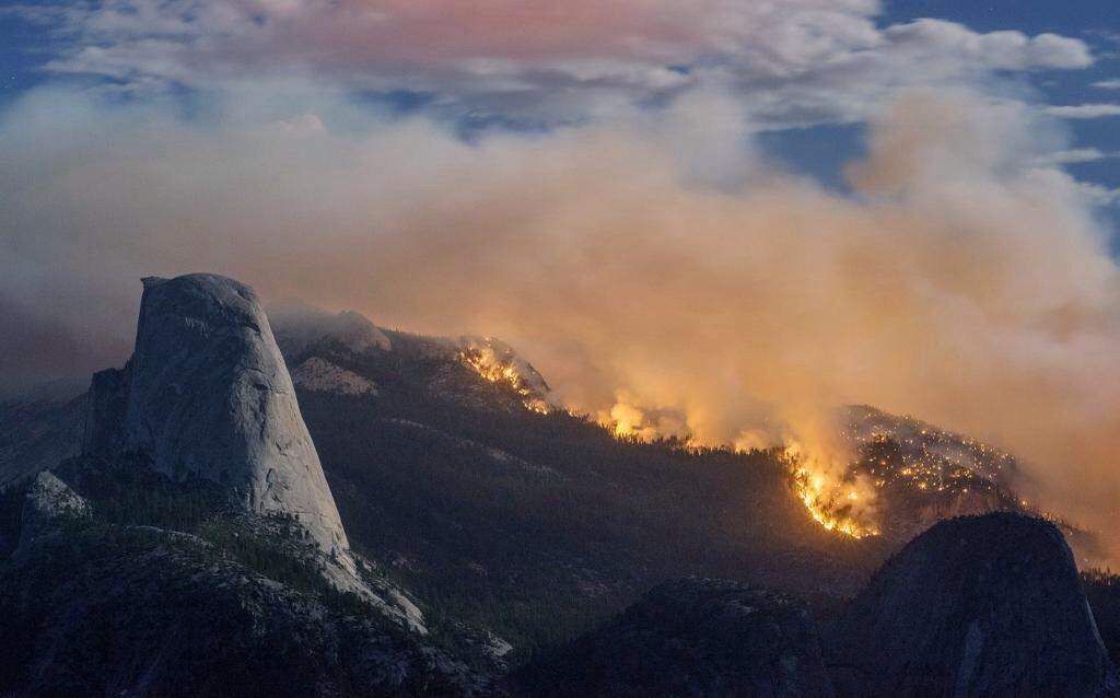
The Fire is located within the designated wilderness of the Yosemite National Park in Mariposa County and is currently within Little Yosemite Valley between Half Dome and Mount Starr King on both sides of the Merced River.
The fire spread significantly due to a wind event which occurred on September 7, 2014.
In Yosemite National Park, fire managers operate within the federal guidelines to assess new naturally caused fires, long enough to determine the threat or benefit the fire may or may not have on the parks ecology. Most fires within the Yosemite National Park naturally burn themselves out. Only a small number of fires show potential for large fire growth and fire suppression action is needed to mitigate the threat to resources. Fire is an important component to the health of the parks sensitive ecology.
Recreation and businesses remain open in the Yosemite National Park except trail areas listed below.
Fire Update
Firefighter and public safety remains the highest priority. Fire crews are being sensitive to environmental and cultural resources in and around the fire area.
Last night’s operational briefing indicated an additional 30 percent containment of the fire. There are still a few isolated heat sources along the fires perimeter with most of the heat dispersed through the fires interior. Crews continue to patrol containment lines and address hot spots as needed. Isolated heat sources are scattered throughout the fire. Air quality continues to increase as fuels are consumed.
Due to the extremely steep, rugged and inaccessible terrain, some fire crews are being flown into the area by helicopter. Air resources, including eight helicopters are being utilized along the fire-line to slow the forward progress of the fire and to cool down hot spots. Due to the potential fire growth and extensive amount of work which remains, a high commitment of resources will be required.
Fire crews are using Minimum Impact Suppression Tactics (M.I.S.T). Fire crews are confining and containing the naturally caused fire by utilizing natural barriers such as, rock to rock, rock to domes, decomposed granite (DG) to sparse fuels. Crews are working hard to maintain natural habitat in the wilderness and working diligently to limit the foot print the suppression effort may cause.
The South Central Interagency Incident Management Team is working with Yosemite National Park Fire Crews on transitioning the fire back to the park. Yosemite National Park will take over the fire on September 16 at 6:00 a.m.
The trail to Half Dome via Little Yosemite Valley is open to day-use only. No overnight camping in any areas impacted by the fire is permitted.
The fire continues to burn through popular hiking areas in Yosemite National Park and trail closures still remain in effect.
Smoke from the Meadows Fire will continue to impact visitors, campers and employees overnight and in the early morning hours in Yosemite Valley.
Fires can produce heavy smoke that blows down into Yosemite Valley. Be prepared for smoke in the unhealthy AQI range normally worse in the mornings with some clearing in the afternoon hours.
Information for schools can be found on this site and links to current air quality updates for this incident will be posted on the California Smoke Information blog
(More)