Showing posts with label 2014 Wildfires. Show all posts

Wednesday, March 25, 2015

Teen Girl Convicted for Setting San Diego County 2014 Cocos Fire #CocosFire #CAFire


Teen Convicted for Setting Destructive San Diego County Fire

MAR 25, 2015 SAN DIEGO (AP) — A judge on Tuesday found a 14-year-old girl guilty of arson for igniting a branch in her backyard that caused last year's devastating wildfire in San Diego County.
Judge Howard Shore found the girl was guilty of multiple felony counts of arson and one misdemeanor count of unlawfully allowing a fire to escape one's control, said Steve Walker of the San Diego County District Attorney's office. Her attorney, Ryan McGlinn, did not immediately return a message for comment.
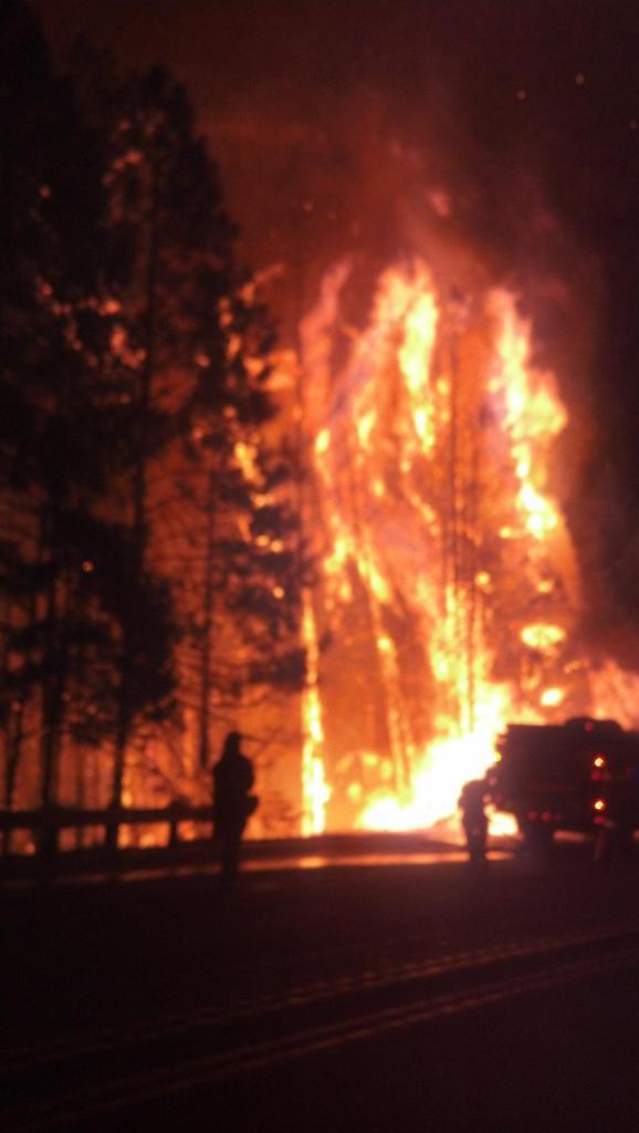
During the two-week trial, prosecutors argued that the girl ignited branches amid a spate of wildfires in the county and laughed about it when she told her sister. An ember traveled nearly a half-mile and ignited the Cocos Fire that destroyed 36 homes, they said.
A hearing to decide her punishment will be scheduled next month. It wasn't immediately known what penalty she might face.
Mitizi McKinney, whose apartment burned in the Cocos Fire, said it was a sad outcome for all.
"Like the judge says, there's no winners in this," McKinney told KNSD-TV, (http://bit.ly/1EO31an ) outside the courtroom. "It's a sad situation. But I feel like justice was definitely served today. The evidence was overwhelming that she started the fire that burned all the homes down."
Restitution for victims is possible, and the parents of the girl could be responsible, though only to a limited dollar amount, according to KSND-TV.
The girl told investigators she "didn't want to kill anybody" — only to "see what would happen" when she set the first of two fires in her backyard, according to an audio tape played in court on Monday
Source: THE ASSOCIATED PRESS - http://www.firehouse.com/news/11897271/teen-convicted-for-setting-destructive-san-diego-county-fire
---------------------------------------------

Friday, February 20, 2015

San Diego: Cocos Fire Teen Suspect Turns Down Plea Deal #CAFire #CocosFire


Cocos Fire suspect: Teen turns down plea deal


SAN DIEGO - A teenage girl accused of sparking the Cocos Fire in San Marcos that destroyed nearly 40 homes turned down a plea deal on Thursday.
The case against the girl, who is not being named because she is a minor, is scheduled to go to trial next month.
The Cocos Fire broke out May 14, 2014 and scorched nearly 2,000 acres. It was one of a spate of more than a dozen wildfires that erupted in the San Diego area in critically hot, dry and windy conditions.
The fires forced hundreds of evacuations and temporarily closed numerous schools and businesses. Damage to private property was estimated at nearly $30 million and the costs of extinguishing the wildfires was nearly $28 million.
Fire victims can call (858) 694-4241 to get more information about the case.
The teenager is facing up to nearly 14 years behind bars if convicted.
Source: http://www.10news.com/news/cocos-fire-suspect-teen-turns-down-plea-deal
---------------------------------------------

Tuesday, October 7, 2014

LODD: Pilot of S2T Air Tanker 81 Fighting Yosemite National Park #DogRockFire Reported Dead After Crash

 CAL FIRE has announced that an S-2T air tanker has crashed killing the contract pilot while fighting the Dog Rock Fire in Yosemite National Park in California.

An air tanker fighting a wildfire near Yosemite National Park in Northern California smashed into a steep canyon wall Tuesday, killing the contract Dyncorp pilot, who was believed to be the only person aboard, officials said. No injuries reported by nearby fire crews on the ground

Air Tanker 81
Credit: 
Bruce Dembecki 
Update 2400: Cal Fire PIO: "This evening emergency personnel were able to access the crash site of a Cal Fire airtanker that had crashed near Yosemite National Park and determined that the pilot on board had died. The Cal Fire airtanker (Tanker 81) based out of the Hollister Air Attack Base had been fighting the Dog Rock Fire near El Portal when officials lost contact with it late this afternoon."
Two DC-7 air tankers and an S-2T air tanker at Paso Robles Air Tanker Base, January 19, 2014. CAL FIRE photo.
Update 2230:
CAL FIRE NEWS RELEASE
California Department of Forestry and Fire Protection
CONTACT: Daniel Berlant
(916) 651-FIRE (3473) @CALFIRE_PIO
RELEASE
DATE: October 7, 2014
Crash of Airtanker Claims the Life of Pilot
Sacramento - This evening emergency personnel were able to access the crash site of a CAL FIRE airtanker that had crashed near Yosemite National Park and determined that the pilot on board had died. The CAL FIRE airtanker (Tanker 81) based out of the Hollister Air Attack Base had been fighting the Dog Rock Fire near El Portal when officials lost contact with it late this afternoon.
The pilot’s family has requested we withhold release of the pilot’s name until all immediate family can be notified.
“This crash underscores just how inherently dangerous wildland firefighting is and the job is further compounded this year by extreme fire conditions,” said Chief Ken Pimlott, CAL FIRE director. “We have secured the crash site and will be cooperating with the NTSB on their investigation.”
“Our thoughts and prayers are with the pilot’s family during this difficult time,” said Jeff Cavarra, program director for DynCorp International.

CAL FIRE operates 22 other Grumman S-2T airtankers across California
Update 1900: - CAL FIRE Reports Pilot Was Found Deceased.
Update 1800: - PER CALFIRE POST EARLIER TODAY : We are saddened to report that this afternoon one of our S2T air tankers crashed while fighting the Dog Rock Fire in Yosemite National Park. The rescue personnel are at scene working through extremely rough terrain to determine the condition of our pilot. Please join us in keeping our Pilot and their family in our thoughts and prayers.
Update 1730: WILDFIRE - YOSEMITE (CA): The following press release from the Cal Fire PIO: "This afternoon contact was lost with one of our airtankers flying over a fire near Yosemite National Park. Emergency personnel are currently responding to the last known location of the aircraft. The airtanker was assigned to the Dog Rock Fire burning near Yosemite’s Arch Rock. The status of the aircraft and the pilot have not been determined. Additional information will be provided as its made available."
The plane went down about 4:30 p.m. within a mile of the park's west entrance, Yosemite spokesman Scott Gediman said. Rescue crews were working their way through difficult terrain to reach the plane's wreckage.

"It's very rugged terrain," said Janet Upton, a spokeswoman for the California Department of Forestry and Fire Protection. "We determined there was a crash, but they're still trying to work their way through pretty rugged terrain to determine the status of the pilot. Obviously we're hoping for the best, but the situation is very serious."

California Highway Patrol Sgt. Chris Michael said he was stopping traffic along state Route 140 at the west entrance to the park about 4:24 p.m. when he witnessed the crash.
Official CAL FIRE NEWS Release 10-7-14
  

Wednesday, September 17, 2014

CA-ENF- KING 27,930 acres 5%, MAPS / EVACUATIONS ONGOING / UPDATE

KING FIRE CA-ENF- KING

Update 1900: 27,930 acres 5% This afternoon fire behavior became extreme with plume domination, crown runs and long range spotting.
On scene photos from CHP Officer Mike Powers
38.782 latitude, -120.604 longitude 

Map data ©2014 Google

Map
Satellite
20 km 
CA-ENF- KING GOOGLE MAP


King Fire Hotspot map
 King Fire Incident Overview

The King Fire is currently located in the canyon of the South Fork of the American River north of the community of Pollock Pines.

Special Announcements: Public Meeting - Wednesday at 6:30 PM. Georgetown Elementary School at 6530 Wentworth Springs Road, Georgetown, CA 95634.

Evacuations: 
Evacuations: 2,155 people
For a full list of the individual roads go to the Sheriff's blog at http://http://pio.edso.org/.[NEW] Shelter Location: Moved to the Camino Seventh-day Adventist Church at 3520 Carson Road, Camino, CA 95709.

Note- The mandatory closure to all residences south of Highway 50 between Fresh Pond and Riverton has been changed to a voluntary advisory.

Mandatory Evacuation Orders are still in effect for the following areas:

Still under Mandatory Evacuation: Forebay Road (north of Moon Lane), Homestead, Randolph Canyon Road

Crystal Basin - Hwy 50 east of Fresh Pond to Icehouse, north on Icehouse Road to Wentworth Springs, west to just above Quintette, to include campgrounds and businesses. Union Valley Reservoir area, Yellow Jacket Campground, Wolf Creek Campground, Stumpy Meadows Campground, Fashoda Campground, Big Hill Lookout Road, Big Hill Road, Blodgett Forest Road, Bridle Path Way, Forest Road, Frontier Road, Helix Flat Ave, Icehouse Road (west side), Jones Fork Power House Road, Middle Loop Road, Mosquito Road, Onion Valley Road, Outer Limits Lane, Little Silver Road, Loop road, Peavine Point Road, Peavine ridge Road, Plum Creek Road, Piolet Creek Road, Robbs Peak Road, Sand Mountain Road, SMUDEA (permittee site), Spring Road, Sunset Drive, Tricometric Trail, Wentworth Springs (south side, east of Pilot Creek Road), and 11 Pines Road.

The entire community of Swansboro, north of the South Fork of the American River between Brushy Creek and Rock Creek.

All roads north of Pony Express Trail from Forebay Road east through Bullion Bend. White Meadows Road and Spring Valley Road.

Voluntary Evacuation Advisories - All evacuations have been lifted for the communities of Gold Ridge and Lakewood Spring. For residences south of Highway 50 between Fresh Pond and Riverton the advisory has been downgraded to voluntary. A Voluntary Evacuation Advisory is still in place for Volcanoville, Quintette, and residents located west of Forebay Road from Blair Road to Pony Express Trail. Additional Voluntary Evacuations Advisories are in place for Badger Hill Road, Marmot Road, Lucky Mine Road, Old Blair Mill Road, Apple Creek court, Applemont Ranch, Chickaree Lane, Longs Creek, Quick Silver Road, Quick Silver Court, and Baltimore Road. - All evacuations have been lifted for the communities of Gold Ridge and Lakewood Spring. For residences south of Highway 50 between Fresh Pond and Riverton the advisory has been downgraded to voluntary. A Voluntary Evacuation Advisory is still in place for Volcanoville, Quintette, and residents located west of Forebay Road from Blair Road to Pony Express Trail. Additional Voluntary Evacuations Advisories are in place for Badger Hill Road, Marmot Road, Lucky Mine Road, Old Blair Mill Road, Apple Creek court, Applemont Ranch, Chickaree Lane, Longs Creek, Quick Silver Road, Quick Silver Court, and Baltimore Road.
Forebay Area: Partial Re-Population - Forebay Road (south of Moon Lane), Alpine Villa Lane, Canyon Edge Road, Caprine Hill Trail, Cayman Court, Deep Haven Road, El Camino Drive, Flatlander Lane, Gail Court, Homestead, Katydid Lane, King of the Mountain Court, King of the Mountain Drive, Kodiak Trail, Moon Lane, Mountain Dew, Romer Boulevard, Sherman Court, Sherman Way, Sunshadow Drive, Terrace Drive

Pollock Pines schools are closed Wednesday.

Basic Information
Current as of 9/17/2014 1:53:30 PM
Incident Type Wildfire
Cause Under Investigation
Date of Origin Saturday September 13th, 2014 approx. 06:37 PM
Location Forebay road, Pollock Pines, CA
Incident Commander Unified Command

Current Situation
Total Personnel 2,466
Size 18,544 Acres
Percent of Perimeter Contained 5%
Fuels Involved: Heavy timber, steep terrain
Significant Events
The fire remained moderately active throughout the night and morning. It became very active in the afternoon with spotting up to one half mile. There was also individual and group torching observed. The fire crossed over Brushy Creek and is backing into the wind towards the west. The fire produced a large column of smoke to the north of the fire but the smoke conditions prevented direct observation of the fire behavior.

Outlook/Planned Actions

Continue to construct, hold, and improve control lines on the south and west portions of the fire. Provide protection for the structures, infrastructure, habitat, and other values at risk. Identify and conduct indirect and direct control lines on the north and west portions of the incident as staffing and conditions allow, providing for firefighter and public safety first.
Projected Incident Activity

The fire is expected to spread to the east, north, and west. The fire has become well established in several canyon bottoms and has crossed over many of them and is burning up to the ridges. In addition, the down canyon winds are expected to return after 2000 hours which will push the fire further down the drainages.

Current Weather / Weather Concerns
Down Canyon winds were observed in the evening.
These down canyon winds are expected to reverse and become up canyon winds in the late morning to early afternoon. The wind is predicted to become a southwest wind in the mid to late afternoon with gusts between 15 and 20 on the ridge tops. Eddying created erratic winds in the steep perpendicular drainages. The strong, erratic winds, dry fuels, high temperatures (84-88), low humidity (18-23), and steep terrain combined to create extreme fire behavior. Temperatures tonight are expected to remain in the mid 60's, with humidity of 40 to 60 percent with the poorest recovery above the thermal belt. The fire is expected to remain relatively active throughout the night, especially at the upper elevations.
An upper low is expected to move overhead through the area on Thursday bringing a chance of Thunderstorms on Friday and Saturday.
---------------------------------------------

Tuesday, September 16, 2014

#WEED WUI FIRE - Devastation from Boles Fire (Video from Weed) #BolesFire #Cafire

WEED - Devastation
Boles Fire: 300 acres, 0% contained. Rapid rates of spread within the community of Weed. Over 100 structures damaged or destroyed. 


Post by Ann Wagner.Video: Angel valley area
This space will be filled in the future with donation information
---------------------------------------------

Monday, September 15, 2014

CA-SKU Boles Fire: 400 acres, 0% contained. Spotting, Multiple structures involved. (MAP)

Boles Fire: CA-SKU Boles Fire
CA-SKU BOLES FIRE PERIMETER MAP 9-15-14


Update 1900: 400 acres, The evacuation for Lake Shastina area has been lifted as of 2015 Hrs., Fire spread to the North has been stopped at this time.


Update 1900: 400 acres, Some Evacuations Lifted Lumber Mill fully involved, Tanker 912 just went OOS mechanical, and has blocked in Tanker 911 on the ramp. AA released both of them. CAL FIRE IMT 4 to the fire. 

Update 1830:  300 acres, 0% contained.  Evacuations 
Rapid rates of spread within the community of Weed. Over 100 structures damaged or destroyed. Interstate 5 was closed for several hours, but has re-opened to both north and south bound traffic. The fire has crossed Highway 97. Highway 97 is closed.

Update 1700: 200 acres, 0% contained.  Evacuations 
Rapid ROS, Fire continues to spot ahead of the main fire. Multiple structures involved.
Evacuation orders for the communities of Carrick and Lake Shastina.

Location: Fire is located on Boles Street, in Weed. 
Fuels: Burning in brush and residential structures.. One structure fully involved, multiple structures threatened. 
Wx: 89 degrees, 13% RH, winds south at 26 mph, with gusts to 39 mph.
---------------------------------------------

Yosemite National Park CA-YNP Meadow Fire Information: 4,772 Acres 80% Containment (PROGRESSION MAP)

MEADOW FIRE CA-YNP MEADOW FIRE 

Yosemite National Park Meadow Fire Information

Update #7 - Release for Sunday, September 14, 2014/Time: 8:00 AM Last night’s operational briefing indicated an additional 30 percent containment of the fire. There are still a few isolated heat sources along the fires perimeter with most of the heat dispersed through the fires interior. Crews continue to patrol containment lines and address hot spots as needed. Isolated heat sources are scattered throughout the fire. Air quality continues to increase as fuels are consumed. Acres burned: 4,772; Containment: 80%; Estimated containment: 9/21/14

Incident Statistics:

Acres Burned: 4,772 Structures Threatened: 0
Containment: 80% Structures Damaged: 0
Fire Start Date: July 19, 2014 Injuries: 2
Fire Discovered: 8/15/14 Total Personnel: 424
Fire Cause: Lightning Cost to date: $4.5 million
Est. Containment: 9/21/14

Summary


 The Fire is located within the designated wilderness of the Yosemite National Park in Mariposa County and is currently within Little Yosemite Valley between Half Dome and Mount Starr King on both sides of the Merced River.

 The fire spread significantly due to a wind event which occurred on September 7, 2014.

 In Yosemite National Park, fire managers operate within the federal guidelines to assess new naturally caused fires, long enough to determine the threat or benefit the fire may or may not have on the parks ecology. Most fires within the Yosemite National Park naturally burn themselves out. Only a small number of fires show potential for large fire growth and fire suppression action is needed to mitigate the threat to resources. Fire is an important component to the health of the parks sensitive ecology.

 Recreation and businesses remain open in the Yosemite National Park except trail areas listed below.

Fire Update

 Firefighter and public safety remains the highest priority. Fire crews are being sensitive to environmental and cultural resources in and around the fire area.

 Last night’s operational briefing indicated an additional 30 percent containment of the fire. There are still a few isolated heat sources along the fires perimeter with most of the heat dispersed through the fires interior. Crews continue to patrol containment lines and address hot spots as needed. Isolated heat sources are scattered throughout the fire. Air quality continues to increase as fuels are consumed.

 Due to the extremely steep, rugged and inaccessible terrain, some fire crews are being flown into the area by helicopter. Air resources, including eight helicopters are being utilized along the fire-line to slow the forward progress of the fire and to cool down hot spots. Due to the potential fire growth and extensive amount of work which remains, a high commitment of resources will be required.

 Fire crews are using Minimum Impact Suppression Tactics (M.I.S.T). Fire crews are confining and containing the naturally caused fire by utilizing natural barriers such as, rock to rock, rock to domes, decomposed granite (DG) to sparse fuels. Crews are working hard to maintain natural habitat in the wilderness and working diligently to limit the foot print the suppression effort may cause.

 The South Central Interagency Incident Management Team is working with Yosemite National Park Fire Crews on transitioning the fire back to the park. Yosemite National Park will take over the fire on September 16 at 6:00 a.m. 

 The trail to Half Dome via Little Yosemite Valley is open to day-use only. No overnight camping in any areas impacted by the fire is permitted.

 The fire continues to burn through popular hiking areas in Yosemite National Park and trail closures still remain in effect.

 Smoke from the Meadows Fire will continue to impact visitors, campers and employees overnight and in the early morning hours in Yosemite Valley.

 Fires can produce heavy smoke that blows down into Yosemite Valley. Be prepared for smoke in the unhealthy AQI range normally worse in the mornings with some clearing in the afternoon hours. 

 Information for schools can be found on this site and links to current air quality updates for this incident will be posted on the California Smoke Information blog

(More)

Sunday, September 14, 2014

Yosemite National Park Meadow Fire Information: 4,761 Acres 50% Containment (MAP)


MEADOW FIRE INFORMATION
Update #6
Release for Sunday, September 14, 2014/Time: 8:00 AM

Incident Statics

Acres Burned: 4,761 Structures Threatened: 0
Containment: 50% Structures Damaged: 0
Fire Start Date: July 19, 2014 Injuries: 2
Fire Discovered: 8/15/14 Total Personnel: 570
Fire Cause: Lightning Cost to date: $3.9 million
Est. Containment: 9/21/14

Summary
  • The Fire is located within the designated wilderness of the Yosemite National Park in Mariposa County and is currently within Little Yosemite Valley between Half Dome and Mount Starr King on both sides of the Merced River.
  • The fire spread significantly due to a wind event which occurred on September 7, 2014.
  • In Yosemite National Park, fire managers operate within the federal guidelines to assess new naturally caused fires, long enough to determine the threat or benefit the fire may or may not have on the parks ecology. Most fires within the Yosemite National Park naturally burn themselves out. Only a small number of fires show potential for large fire growth and fire suppression action is needed to mitigate the threat to resources. Fire is an important component to the health of the parks sensitive ecology.
  • Recreation and businesses remain open in the Yosemite National Park except trail areas listed below.
Fire Update
  • Firefighter and public safety remains the highest priority. Fire crews are being sensitive to environmental and cultural resources in and around the fire area.
  • Last night’s infrared flight revealed there are a few isolated heat sources along the fires perimeter with most of the heat dispersed through the fires interior. Areas of intense heat seem to concentrate in three main areas. These areas are north end of the fire and two areas in the southeast. The west flank of the fire continues to cool. There are still isolated heat sources scattered throughout the fire.
(More)

Saturday, September 13, 2014

Yosemite N.P. CA-YNP #Meadow Fire Update 4,960 Acres Burned 50% Containment (MAP) #CaFire

MEADOW FIRE CA-YNP- Meadow
Update #5 Saturday, September 13, 2014/Time: 8:00 AM
Yosemite National Park Meadow Fire View Showing Half Dome
Incident Statics
Acres Burned: 4,960 Structures Threatened: 0
Containment: 50% Structures Damaged: 0
Fire Start Date: July 19, 2014 Injuries: 1
Fire Discovered: 8/15/14 Total Personnel: 570
Fire Cause: Lightning Cost to date: $3.3 million
Est. Containment: 9/21/14

Summary
 The Fire is located within the designated wilderness of the Yosemite National Park in Mariposa County and is currently within Little Yosemite Valley between Half Dome and Mount Starr King on both sides of the Merced River.
The fire spread significantly due to a wind event which occurred on September 7, 2014.
In Yosemite National Park, fire managers operate within the federal guidelines to assess new naturally caused fires, long enough to determine the threat or benefit the fire may or may not have on the parks ecology. Most fires within the Yosemite National Park naturally burn themselves out. Only a small number of fires show potential for large fire growth and fire suppression action is needed to mitigate the threat to resources. Fire is an important component to the health of the parks sensitive ecology.
Recreation and businesses remain open in the Yosemite National Park except trail areas listed below.

Fire Update
Firefighter and public safety remains the highest priority. Fire crews are being sensitive to environmental and cultural resources in and around the fire area.
Last night’s infrared flight revealed some fire growth in the fire to the southeast portion of the fire, where a small burnout operation took place, but otherwise there was minimal perimeter growth. Intense heat still remains along the east flank. Crews and helicopters will continue to work known spot fires outside the line. 

Approximate Location

37.712 latitude, -119.509 longitude 
Map data ©2014 Google

Map
Satellite
5 km 

Twitter Buttons

****REMINDER**** Every fire has the ability to be catastrophic. The wildland fire management environment has profoundly changed. Growing numbers of communities, across the nation, are experiencing longer fire seasons; more frequent, bigger, and more severe, fires are a real threat. Be careful with all campfires and equipment.

"I am a firm believer in the people. If given the truth, they can be depended upon to meet any national crisis. The great point is to bring them the real facts, and beer." --Abraham Lincoln

View blog top tags
---------------------
CLICK HERE TO GO BACK TO TOP OF CALIFORNIA FIRE NEWS HOME PAGE

Subscribe via email to California Fire News - Keep track of Cal Fire News

Enter your email address:

Delivered by FeedBurner