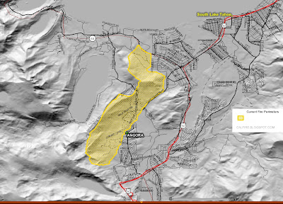
Composite GEO-MAC maps of South Lake Tahoe
ANGORA FIRE MAPS
ANGORA FIRE PERIMETER MAPS
Thermal satellite map view of ANGORA FIRE
 Angora fire map perimeters
CLICK MAPS TO ENLARGE
UPDATED: HMS 2007-06-26; Thermal MODIS: 2007-06-27 1539 (GMT); Fire Perimeters 2007-06-27; Sit Reports 2007-06-26
Perimeters are collected in the field by a variety of means, including infrared flights, and by using a GPS unit to map the perimeter. Please NOTE: GeoMAC only displays perimeter data as they are submitted by field offices. Since data are not received for all fires, you may not be able to view perimeters for every fire.
A perimeter is displayed in one of two ways depending upon how old it is. Once a perimeter is more than two days old, or is replaced by a more current perimeter, it is displayed in blue-gray in the Past 2007 Perimeters layer. Also, perimeters are usually no longer collected in the field once a fire is no longer growing in size and is mostly contained.

No comments:
Post a Comment
CAL FIRE NEWS LOVES COMMENTS...
- Due to rampant abuse, we are no longer posting anonymous comments. Please use your real OpenID, Google, Yahoo, AIM, Twitter, Flickr name.