Tuesday, August 27, 2013

Yosemite Area Wildfire Known As The Rim Fire May Impact Tuolumne Grove Of Giant Sequoias Tunnel Tree Soon. #CaFire

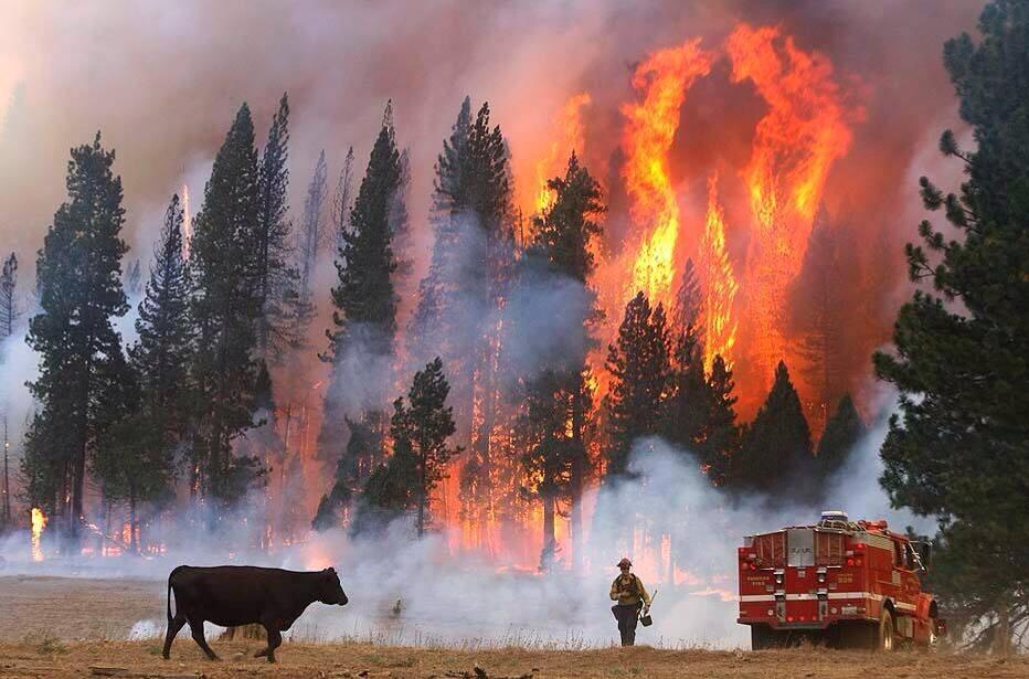
Tuolumne Grove Of Giant Sequoias. Big Flat road Entrance, Crane Flat Lookout Tower and the Whole of Yosemite Valley And Back-Country Threatened.
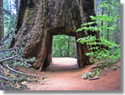
The Historic Tunnel Tree Tuolumne Grove of Giant Sequoias
 PERIMETER HOT SPOT MAP 8-27-13 MORNING WITH TUOLUMNE GIANT TREES BIG OAK FLAT YNP LOCATION 
PERIMETER HOT SPOT MAP 8-27-13 MORNING WITH TUOLUMNE GIANT TREES BIG OAK FLAT YNP LOCATION
PERIMETER HOT SPOT MAP 8-27-13 MORNING WITH TUOLUMNE GIANT TREES BIG OAK FLAT YNP LOCATION 

Inset shows close topographic map of  Tunnel Tree Tuolumne Grove of Giant Sequoias
Tuolumne Grove is a sequoia grove located near Crane Flat in Yosemite National Park, at 37°46′09″N 119°48′36″WCoordinates37°46′09″N 119°48′36″W.[1] It is about 16 miles (26 km) west of Yosemite Village on Tioga Pass Road. The grove contains many conifers, including a few Sequoiadendron giganteum as well as Abies concolor and Pinus lambertiana.
While smaller than the Mariposa Grove the Tuolumne Grove is less visited[2] and provides a more secluded experience.
Google Map of Tunnel Tree Tuolumne Grove of Giant Sequoias General Area

View Larger Map
---------------------------------------------

Quick Look: California Fires Today Tuesday, August 27, 2013

California Statewide Fire Summary
Tuesday, August 27, 2013

Today over 9,300 CAL FIRE, local and federal firefighters are on the frontlines
battling 10 active major wildfires across California. 
Full containment on the Spring Peak Fire that burned into California near Bodie State Park in Mono County. 
Tiny Klout Flag66CAL FIRE NEWS ‏@CalFireNews1h
, NE of Mono Lake CA, FRA 14,200 acres 100% contained. -* No Damage In Town of Bodie *-

Rim Fire’s continues growth near Yosemite National Park and historic gold country towns of California, this morning becoming the 7th largest wildfire in California’s recorded history.
  • 3,700 firefighters 
  • 4,500 homes threatened remained threatened along the Hwy 108 corridor in Tuolumne County. 
  • Majority of the large wildfires are burning on federal land, CAL FIRE and local fire 
    departments continue to support the US Forest Service in their battle.
Weather: A low pressure system off the coast could bring some moisture along the Sierra, however most areas in Northern California could continue to see southwest winds. If the weather system moves onshore, it could bring some unseasonably cool conditions, which help aid firefighters in their containment efforts.
 In Southern California rainfall is likely to continue over the mountains and deserts.

Todays Major Fires of Interest:

**CAL FIRE Incidents**
Deer Fire, Tehama County
10 miles east of Los Molinos
* 10,378 acres – 75% contained
* Full containment expected on Thursday, 8/29

**Unified Command Fires**
Rim Fire ,Tuolumne County Stanislaus National Forest/CAL FIRE
* northeast of Groveland
* 179,481 acres - 20% contained
* Evacuations in effect
* 4,500 residences threatened

**Federal Fires** American Fire, Placer County US Forest Service – Tahoe National Forest
northeast of Foresthill
* 24,935 acres - 88% contained
* CAL FIRE is assisting

Fish Fire, Tulare County US Forest Service – Sequoia National Forest
25 miles northeast of Springville
* 1,900 acres - 7% contained

Little Fire, Riverside County US Forest Service – San Bernardino National Forest
Off Hwy 74 near Lake Hemet
* 100 acres - 70% contained

Gobblers Fire, San Bernardino County US Forest Service – San Bernardino National Forest
6 miles south of Wrightwood
* 413 acres - 93% contained

Spring Peak Fire, Mono County FINAL US Forest Service – Humboldt-Toiyabe National Forest 15 miles northeast of Mono Lake
* 14,200 acres - 100% contained
* The fire is primarily in Nevada but did burn into California near Bodie State Park

Orleans Complex, Siskiyou County
US Forest Service – Six Rivers National Forest, 6 miles southeast of Somes Bar
* 21,188 acres - 45% contained

Corral Complex, Humboldt County US Forest Service – Six Rivers National Forest,
east of the Hoopa Indian Reservation
* 11,732 acres - 5% contained

Salmon River Complex, Siskiyou County US Forest Service – Klamath National Forest, 1 mile west of Sawyers Bar 
* 14,771 acres - 95% contained

Aspen Fire, Fresno County US Forest Service – Sierra National Forest near Huntington Lake
* 22,791 acres - 95% contained

For the latest on the fires visit CAL FIRE NEWS
---------------------------------------------

Discussion is the Rim Wildland Fire at 257,314 acres, 92% Type 3 IC Otterson/Singer, now 3rd largest wildfire in California history? #CaFire

New List Of Largest California Wildfires  
Rim Fire Cow
Credit: Don Bartletti of @latimes. pic.twitter.com/nDqntiI8R8

Discussion is the Rim Wildland Fire 6th or 7th largest wildfire in California history?

CFN Tweet:  has grown to 179,481 acres, 20% contained, now making it the 6th largest Fire in California History.

Reply Tweet: No, 1889 fire would drop to 8. Your list probably doesn't have 1932 Matilija fire.

List Compiling Problems noted:
1 CAL FIRE has wrong acreage listed for Station Fire. 2 CAL FIRE Lists a fire called  Bear Wallow Siskiyou at 192,038 acres not on other lists but same size as Klamath Complex June 2008?


Fire Update 10-25 0900: 257,314 (402 sq miles) 100% CONTAINED
Fire Update 9-30 0900: 257,135 acres, 92% Type 3 IC Otterson/Singer
Fire Update 9-23 1900: 257,126 acres, 84% contained, ICT 2, Cooper
Fire Update 9-22 1900: 257,097 acres, 84% contained
Fire Update 9-16 1900: 256,528 acres, 84%
Fire Update 9-12 1900: 255,858 acres, 80%
Fire Update 9-9 0900: 254,685 acres, 80% contained
Fire Update 9-8 0900: 253,332 acres, 80%
Fire Update 9-7 1900: 252,521 acres, 80% contained
Fire Update 9-7 0900: 252,156 acres, 80% contained
Fire Update 9-6 0900: 246,350 acres, 80% contained
Fire Update 9-2 0900: 235,841 acres, 70% contained
Fire Update 9-2 0900: 228,670 acres, 60% contained  now 358 square miles an area larger than the cities of San Francisco, Oakland and San Jose combined.  
Fire Update 9-1 1900: 224,777 acres 
Fire Update 8-30 1900: 222,777 acres 
Fire Update 8-30 0900: 219,277 acres
Fire Update 8-29: 213,414 acres
Fire Update 8-29: 199,737 acres
Fire Update 8-27: Rim Fire now 192,466 acres 30% cont. 4,500 structures remain threatened on east and west perimeter. For comparison New York City's land area covers 321 square miles, over 205,000 acres. 

Fire Update 8-26: Rim Fire now 184,481 acres

Updated 8-28 Modified List Of Largest California Wildfires
#1 - Santiago Canyon Fire of 1889: 300,000 acres (469 sq mi; 121,406 ha) est.
#2 - Cedar Fire: 273,246 acres (427 sq mi; 110,579 ha) 
#3 - Rim Fire:  257,314 (402 sq miles)
#4 -
 Zaca Fire: 240,207 acres (375 sq mi; 97,208 ha
#5 -Matilija Fire: 220,000 acres (344 sq mi; 89,031 ha)
#6 - Witch Fire: 197,990 acres (309 sq mi; 80,124 ha)
#7 -  Klamath Complex 192,038  acres June 2008 (CDF - *Bear Wallow Siskiyou)
#8 - Marble-Cone Fire: 177,866 acres (720 km2) 
#9 - Laguna Fire: 175,425 acres (274 sq mi; 70,992 ha) 
#10 - Basin Complex fire: 162,818 acres (254 sq mi; 65,890 ha)
#11 - Day Fire: 162,700 acres (254 sq mi; 65,842 ha)
#12 - Station Fire: 160,557 acres (251 sq mi; 64,975 ha) http://inciweb.org/incident/1856/
#13 - McNally: July 2002 TULARE 150,696

Updated 8-28 Modified List Of Largest California Wildfires
#1 - Santiago Canyon Fire of 1889: 300,000 acres (469 sq mi; 121,406 ha) est.
#2 - Cedar Fire: 273,246 acres (427 sq mi; 110,579 ha) 
#3 - Zaca Fire: 240,207 acres (375 sq mi; 97,208 ha)
#4 -
  Rim Fire:  222,777 acres 
#5 -Matilija Fire: 220,000 acres (344 sq mi; 89,031 ha)
#6 - Witch Fire: 197,990 acres (309 sq mi; 80,124 ha)
#7 -  Klamath Complex 192,038  acres June 2008 (CDF - *Bear Wallow Siskiyou)
#8 - Marble-Cone Fire: 177,866 acres (720 km2) 
#9 - Laguna Fire: 175,425 acres (274 sq mi; 70,992 ha) 
#10 - Basin Complex fire: 162,818 acres (254 sq mi; 65,890 ha)
#11 - Day Fire: 162,700 acres (254 sq mi; 65,842 ha)
#12 - Station Fire: 160,557 acres (251 sq mi; 64,975 ha) http://inciweb.org/incident/1856/
#13 - McNally: July 2002 TULARE 150,696

Updated 8-28 Modified List Of Largest California Wildfires
#1 - Santiago Canyon Fire of 1889: 300,000 acres (469 sq mi; 121,406 ha) est.
#2 - Cedar Fire: 273,246 acres (427 sq mi; 110,579 ha) 
#3 - Zaca Fire: 240,207 acres (375 sq mi; 97,208 ha)
#4 - Matilija Fire: 220,000 acres (344 sq mi; 89,031 ha)
#5 - Witch Fire: 197,990 acres (309 sq mi; 80,124 ha)
#6 -  Rim Fire192,466 acres( 300.728 square miles ) August 29 2013
#7 -  Klamath Complex 192,038  acres June 2008 (CDF - *Bear Wallow Siskiyou)
#8 - Marble-Cone Fire: 177,866 acres (720 km2) 
#9 - Laguna Fire: 175,425 acres (274 sq mi; 70,992 ha) 
#10 - Basin Complex fire: 162,818 acres (254 sq mi; 65,890 ha)
#11 - Day Fire: 162,700 acres (254 sq mi; 65,842 ha)
#12 - Station Fire: 160,557 acres (251 sq mi; 64,975 ha) http://inciweb.org/incident/1856/
#13 - McNally: July 2002 TULARE 150,696

Apparently CDF -Bear Wallow Siskiyou was the Klamath Complex for the USFS
Panther & North Ukonom fires - 75% contained, 52,813 acres 
Bear Wallow Complex (Anthony Milne, Caribou, & South Ukonom fires) - 75% contained, 50,319 acres 
Siskiyou/Blue 2 Complex - 95% contained, 87,469 acres

Updated 8-27 Modified List Of Largest California Wildfires
#1 - Santiago Canyon Fire of 1889: 300,000 acres (469 sq mi; 121,406 ha) est.
#2 - Cedar Fire: 273,246 acres (427 sq mi; 110,579 ha) 
#3 - Zaca Fire: 240,207 acres (375 sq mi; 97,208 ha)
#4 - Matilija Fire: 220,000 acres (344 sq mi; 89,031 ha)
#5 - Witch Fire: 197,990 acres (309 sq mi; 80,124 ha)
#6 - Klamath Complex 192,038  acres June 2008 (CDF - *Bear Wallow Siskiyou)
#7 - Rim Fire 184,481 acres August 27 2013  
#8 - Marble-Cone Fire: 177,866 acres (720 km2) 
#9 - Laguna Fire: 175,425 acres (274 sq mi; 70,992 ha) 
#10 - Basin Complex fire: 162,818 acres (254 sq mi; 65,890 ha)
#11 - Day Fire: 162,700 acres (254 sq mi; 65,842 ha)
#12 - Station Fire: 160,557 acres (251 sq mi; 64,975 ha) http://inciweb.org/incident/1856/
#13 - McNally: July 2002 TULARE 150,696

Apparently CDF -Bear Wallow Siskiyou was the Klamath Complex for the USFS
Panther & North Ukonom fires - 75% contained, 52,813 acres 
Bear Wallow Complex (Anthony Milne, Caribou, & South Ukonom fires) - 75% contained, 50,319 acres 
Siskiyou/Blue 2 Complex - 95% contained, 87,469 acres

List Of Largest California Wildfires
#1 - Santiago Canyon Fire of 1889: 300,000 acres (469 sq mi; 121,406 ha) est.
#2 - Cedar Fire: 273,246 acres (427 sq mi; 110,579 ha) 
#3 - Zaca Fire: 240,207 acres (375 sq mi; 97,208 ha)
#4 - Matilija Fire: 220,000 acres (344 sq mi; 89,031 ha)
#5 - Witch Fire: 197,990 acres (309 sq mi; 80,124 ha)
#6 - Klamath Complex 192,038  acres June 2008 (CDF - *Bear Wallow Siskiyou)
#7 - Rim Fire 179,481+  August 2013  
#8 - Marble-Cone Fire: 177,866 acres (720 km2) 
#9 - Laguna Fire: 175,425 acres (274 sq mi; 70,992 ha) 
#10 - Basin Complex fire: 162,818 acres (254 sq mi; 65,890 ha)
#11 - Day Fire: 162,700 acres (254 sq mi; 65,842 ha)
#12 - Station Fire: 160,557 acres (251 sq mi; 64,975 ha) http://inciweb.org/incident/1856/
#13 - McNally: July 2002 TULARE 150,696

* Apparently CDF -Bear Wallow Siskiyou was the Klamath Complex for the USFS
Panther & North Ukonom fires - 75% contained, 52,813 acres 
Bear Wallow Complex (Anthony Milne, Caribou, & South Ukonom fires) - 75% contained, 50,319 acres 
Siskiyou/Blue 2 Complex - 95% contained, 87,469 acres
-------------------------------------
My original list
#1 - Santiago Canyon Fire of 1889: 300,000 acres (469 sq mi; 121,406 ha) est.
#2 - Cedar Fire: 273,246 acres (427 sq mi; 110,579 ha)
#3 - Zaca Fire: 240,207 acres (375 sq mi; 97,208 ha)
#4 - Matilija Fire: 220,000 acres (344 sq mi; 89,031 ha)
#5 - Witch Fire: 197,990 acres (309 sq mi; 80,124 ha)
#6 - Marble-Cone Fire: ~178,000 acres (720 km2)
#7 - Laguna Fire: 175,425 acres (274 sq mi; 70,992 ha)
#8 - Basin Complex fire: 162,818 acres (254 sq mi; 65,890 ha)
#9 - Day Fire: 162,700 acres (254 sq mi; 65,842 ha)
#10 - Station Fire: 160,557 acres (251 sq mi; 64,975 ha)
#11 - McNally Fire: 150,670 acres (235 sq mi; 60,974 ha)
#12 - Old Fire (2003): 91,281 acres (143 sq mi; 36,940 ha)
#13 - Harris Fire: 90,440 acres (141 sq mi; 36,600 ha)
#14 - Indians Fire: 76,554 acres (120 sq mi; 30,980 ha)
#15 - Moonlight Fire: 65,000 acres (102 sq mi; 26,305 ha)
#16 - Sawtooth Complex fire: 61,700 acres (96 sq mi; 24,969 ha)
#17 - Ranch Fire: 58,401 acres (91 sq mi; 23,634 ha)

List derived from: http://en.wikipedia.org/wiki/List_of_California_wildfires
-------------------------------------
CDF List: 
1 - CEDAR (HUMAN)

October 2003 SAN DIEGO 273,246
2 - ZACA (HUMAN)
July 2007 SANTA BARBARA 240,207
3 - BEAR WALLOW SISKIYOU 192,038
4 - MATILIJA (UNDETERMINED)
September 1932 VENTURA 220,000
5 - WITCH (POWERLINES)
October 2007 SAN DIEGO 197,990
6 - MARBLE CONE (LIGHTNING)
July 1977 MONTEREY 177,866
7 - LAGUNA (POWERLINES)
September 1970 SAN DIEGO 175,425
8 - BASIN COMPLEX (LIGHTNING)
June 2008 MONTEREY 162,818
9 - DAY FIRE (HUMAN)
September 2006 VENTURA 162,702
10 - MCNALLY (HUMAN)
July 2002 TULARE 150,696
11 - STANISLAUS COMPLEX (LIGHTNING)
August 1987 TUOLUMNE 145,980
12 - STATION FIRE (UNDER INVESTIGATION)
August 2009 LOS ANGELES 144,743 
13 - BIG BAR COMPLEX (LIGHTNING)
August 1999 TRINITY 140,948
14 - CAMPBELL COMPLEX (POWERLINES)
August 1990 TEHAMA 125,892
15 - WHEELER (ARSON)
July 1985 VENTURA 118,000
16 - SIMI (UNDER INVESTIGATION)
October 2003 VENTURA 108,204
17 - HWY. 58 (VEHICLE)
August 1996 SAN LUIS OBISPO 106,668
18  - IRON ALPS COMPLEX (LIGHTNING)
June 2008 TRINITY 105,805
19 - CLAMPITT (POWERLINES)
September 1970 LOS ANGELES 105,212
20 - BAR COMPLEX (LIGHTNING)
July 2006 TRINITY 100,414
Derived from  CAL FIRE .pdf: http://www.fire.ca.gov/about/downloads/20LACRES.pdf
-------------------------------------

---------------------------------------------

Saturday, August 24, 2013

CA-BDF-Little San Bernardino National Forest, Riverside County 97 acres, 100% contained, [FINAL] #CaFire

Little Fire CA-BDF-11557, CA-BDF Little FireSan Bernardino National Forest, Riverside County

Update 8/29 0900: 97 acres, 100% contained, Dinkel, Type 3 IC
This will be the last report on this incident unless conditions warrant.
Update 8/29 0900: 97 acres, 95% cont. , Expected Containment 09/08/2013, Dinkel, Type 3 IC 
Update 8/26 0900: 100 acres, 50% contained, Expected Containment 09/08/2013
Fire is burning in rough terrain with several snags within the fire boundary. Snags will be felled by Vista Grande Hot Shots once they arrive from the Gobblers Fire. Fire will be monitored during night shift due to safety concerns with snags and terrain.
Location: *
Reported Date/time: *
IA: *
ROS: Fire burning at a rapid rate of spread
ROC: 20+ acres, 0% contained
---------------------------------------------

LAFD Greater Alarm Structure Fire: 100+ Firefighters Battle a Motel Blaze in Van Nuys; 4 Occupants Injured. #CaFire

CA-LAFD-0495

Greater Alarm Structure Fire
6500 Sepulveda Bl
Van Nuys
Saturday, August 24,  2013
TIME: 11:13 AM
INCIDENT #0495

VAN NUYS - Over 100 Los Angeles Firefighters battled a blaze in a Van Nuys motel where four were injured on August 24, 2013.

video

At 11:14 am the Los Angeles Fire Department (LAFD) arrived at 6500 Sepulveda Boulevard in four minutes to find smoke billowing out of the second story of a two-story "O" shaped motel, named the Voyager Motor Inn. Additional companies were immediately requested.  

Firefighters rushed inside with hose-lines and laddered the second story windows for trapped victims to safely escape. Additional firefighters performed vertical ventilation on the roof with chainsaws while others performed rapid Search and Rescue operations.

Fire attack was difficult due to the building lay out and the volume of fire throughout the second floor. The motel had 120 units, 60 were occupied.

The fire appeared to have originated in unit 246. The occupant rushed out leaving the door open and the flames rapidly spread, additional occupants did the same, causing the fire to blow down the hallway like a horizontal chimney, fueled by a light wind.

The bulk of the damage occurred on the second floor. Flames and smoke damaged approximately 50 units, and multiple units on the first floor suffered water damage. The motel was equipped with smoke alarms, not with fire sprinklers.

The flames were confined to the motel and no nearby structures were damaged. A total of  147 firefighters (including those initially dispatched and additional firefighters assisting with overhaul), all under the command of Battalion Chief Don Reyes, extinguished the flames in one hour and 16 minutes. Firefighters remained in an offensive attack.

The LAFD worked closely with various departments and organizations including CERT. The Emergency Management Department played a key role in collaborating the with the American Red Cross and with Recreation and Parks to open up the Delano Recreation Center for the approximately 50 displaced residents. Additionally, Metropolitan Transportation Authority was utilized to transport these residents from the fire scene to the shelter location. LAPD assisted with scene security and authentication of proper occupants during the collection of personal property.

A total of four persons were treated on scene. Three patients ranging from a five month-old female to a 32 year-old female, all with non-life-threatening injuries were transported to local hospitals. No one was burned.

The cause of the fire is Undetermined, and remains under active investigation by the LAFD Arson Section. The estimated dollar loss is still being tabulated.
Dispatched Units:  E39 E288 T88 E90 RA881 E100 RA100 E289 T89 EM14 BC5 BC10 E102 E81 BC14 E489 E7 E273 T73 E293 T93 DC1 EM17 BC12 UR88 T27 E227 E27 UR27 BC5 AR2 RA27 RA39 EA1 E290 T90 E261 T61 E105 E83 RA88 RA90 EM9 T60 E260 E5 E26 T12 E212 E27 DC1 BC14 T39 E239
---------------------------------------------

CA-AEU-Empire 38 acres and 70%,El Dorado County Empire Creek Cir, Georgetown #CaFire

CA-AEU-Empire  (El Dorado County)

Road Closure: Closing Lower Main, Greenwood Rd, and Rolling Hills


Update 1945: 38 acres and 70% contained.
Update 1830: CAL FIRE stating 50% contained now.
Update 1800: 45 acres and 35% contained. small fire on Slug Gulch road contained at 1 acre at 1750 hrs.
Update 1700: 15 acres, XSA initial Attack Strike Team sent at 1545 E335, E336, E363, E428, E332, BC15
Update 1600:  6-8 acres, AA requesting 2 add'l tankers.

Location: 4060 Empire Creek Cir, Georgetown - Hwy 193 & Empire Creek Circle near Georgetown
Reported Date/time: Aprrox 1500hrs
IA:
ROS: Moderate to Rapid
ROC: Fire rapidly advancing on houses on Empire Creek Cir, also in the area of Lower Main Street, Greenwood Rd and Rolling Hills Dr
Structure Threats: Structures: are not currently threatened
Concerns: Special Hazard Power Lines Down
Resources: AA 503 & Tanker 88 
Cooperating Agencies: *
Weather Info: *
Special Conditions: *
Other Comments: *
Radio Frequencies: AEU Local 151.190 XED Command 155.9025 Tac 9 151.385
Maps: *
Agency Website: *
Online Scanner: *
Live Video: *
Web Cams: *
---------------------------------------------

Friday, August 23, 2013

CA-TGU Deer Fire: 11,429 acres, 98% contained. Tehama County Expect containment today IMT 3 (Darnell). #CaFire

Deer Fire: CA-TGU DeerTehama County
Deer Fire 8-24-13
Update 8/29 0900: 11,429 acres, 98% contained. Expected containment 8/29. CAL FIRE IMT 1 (Cone). The fire remained within current containment lines overnight. Firefighters will continue to improve all handlines. Mop up will continue to provide black line depth to reduce the threats of spots across containment lines. Hand crews will need rotary wing support to shuttle personnel to and from the fire. Fire suppression repair continues.
Update 8/28 0900: 11,429 acres, 93% contained. Expected containment 8/29.  CAL FIRE Team (Cone), Continue to improve all handlines. Mop up will continue to provide black line depth to reduce the threats of spots across containment lines. Hand crews will need rotary wing support to shuttle personnel to and from the fire. The fire suppression repair plan has been started. Personnel continue to deepen black line to reduce any spotting potential from interior islands.
Update 8/27 1900: 10,589 acres, 88% contained. Expected containment 8/29. The fire remained within current containment lines throughout the night.  Personnel continue to deepen black line to reduce any spotting potential from interior islands.  Continue to improve all handlines.  Mop up will continue to provide black line depth to reduce the threats of spots across containment lines.
Update 8/27 0900: 10,589 acres, 88% contained. Expected containment 8/29. The fire remained within current containment lines throughout the night.  Personnel continue to deepen black line to reduce any spotting potential from interior islands.  Continue to improve all handlines.  Mop up will continue to provide black line depth to reduce the threats of spots across containment lines.
Update 8/26 0900: 10,325 acres, 45% contained. Expected containment 8/30/2013. Cone, CAL FIRE Team 2. Fire behavior pushed the fire into the north fork of the Mill Creek Drainage and east into the Ishi Wilderness. The fire continues to burn in the Big Dry Creek drainage with short range spotting to the north.  Continue direct hand line construction along the east side of the fire through the Ishi Wilderness and north to the north fork of Mill Creek to prevent further spread to the north and east. Contingency lines are currently being constructed north of the fire along the Peligreen Trail.
Update 8/25 1900:10,310 acres, 35% contained. Expected containment 08/30/2013. CAL FIRE Team 2 Cone. The fire is located 10 miles east of Los Molinos. Fire behavior pushed the fire into the north fork of the Mill Creek Drainage and east into the Ishi Wilderness. Fire continues to burn in the Big Dry Creek drainage with short range spotting to the west. Fire continues to burn under the 500kv power lines serving 15 western states. Hand line construction has been direct when possible.
Update 8-24 1900: 10,270 acres, 21% contained. Expected containment 08/30/2013. CAL FIRE Team 2 Cone. The fire is located 10 miles east of Los Molinos.Fire behavior pushed the fire into the Mill Creek and Big Dry Creek drainages and the Ishi Wilderness. Fire continues to burn under 500kv power lines serving 15 Western states. Hand line construction has been direct when possible. Fire has crossed Big Dry Creek and is currently South of Mill Creek. Establish direct hand lines along the East side of the fire through the Ishi Wilderness and North to Mill Creek to prevent further spread to the North and East.
Update 8-24 0900: 1,715 acres, 15% contained. IMT 3 (Darnell). Continued threat to 500KV power lines  Due to difficult terrain, there is limited access for ground resources.
Update 8-23 1900: 200 acres, 0% contained. Fire has crossed into the Deer Creek drainage. Continued threat to 500KV power lines.

Location: Tehama County,10 miles east of Los Molinos. 
Reported Date/time: *
IA: *
ROS: *
ROC: *
Structure Threats: *
Concerns: Fire has crossed into the Deer Creek drainage. Continued threat to 500KV powerlines.
Resources: 
Cooperating Agencies: *
Weather Info: *
Special Conditions: *
Other Comments: *
Radio Frequencies: *
Maps: *
Agency Website: *
Online Scanner: *
Live Video: *
Web Cams: *
---------------------------------------------

Twitter Buttons

****REMINDER**** Every fire has the ability to be catastrophic. The wildland fire management environment has profoundly changed. Growing numbers of communities, across the nation, are experiencing longer fire seasons; more frequent, bigger, and more severe, fires are a real threat. Be careful with all campfires and equipment.

"I am a firm believer in the people. If given the truth, they can be depended upon to meet any national crisis. The great point is to bring them the real facts, and beer." --Abraham Lincoln

View blog top tags
---------------------
CLICK HERE TO GO BACK TO TOP OF CALIFORNIA FIRE NEWS HOME PAGE

Subscribe via email to California Fire News - Keep track of Cal Fire News

Enter your email address:

Delivered by FeedBurner