Thursday, November 29, 2012

Severe Weather Alert: Coastal River Flooding Likely This Weekend


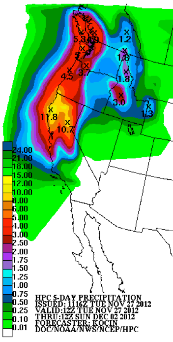
 Periods of rain will move across the region through Sunday night. Central California will receive between 2 and 6 inches of rainfall while less than an inch of rainfall is expected over Southern California. There will be south to west winds of 15 to 30 mph across Central California through Sunday afternoon
WEATHER DISCUSSION: 
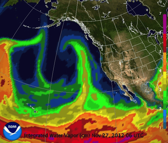
***Heavy rain over Central California through the weekend. Windy in the northern deserts***

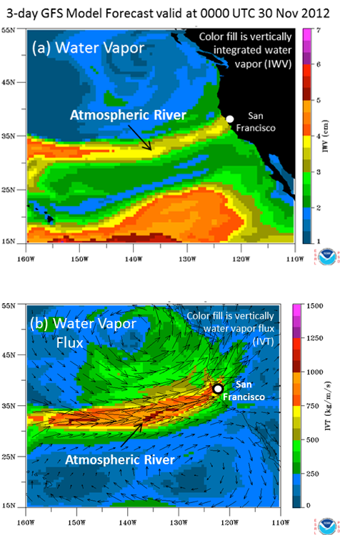
 A deep low pressure area coupled with a moisture-laden jet stream will lead to heavy rainfall over the central part of the state during the next few days. The bulk of the precipitation looks to occur on Friday and again Sunday, with light showers, or drizzle, occurring between these two
main frontal passages. Today, expect intermittent light rain and drizzle before the next band of moderate to heavy rain moves into Central California Friday. 

FLOOD WATCH
Flooding: Rivers in Northern California and Southern Oregon are expected to flood in the next few days, the National Weather Service predicts.

No rivers were at flood stage as of Thursday, but the current storm will last for several days, drenching the area with heavy rain and high winds.

Moderate flooding is expected by Sunday on California's Sacramento River above Bend Bridge and at Red Bluff Diversion Dam. Rainfall totals of 5 to 10 inches are possible through the weekend, and river levels throughout the region will likely remain high through Monday. 

In Oregon, the Coquille River near Coquille will rise about a foot above flood stage Saturday and remain there at least through Monday. Other streams and rivers in Southwest Oregon will also rise and possibly flood.

Debris flows: Possible, especially near areas burned in recent wildfires.

Temperatures: will remain cool today and throughout the weekend with highs in the 60s at lower elevations. 

Winds: It will turn very windy across the Owens Valley, Mono County and the Inyo N.F. where some south and southwest winds of 30-40 mph with gusts over 70 mph will be possible tonight and Friday and again Saturday night through Sunday. 

Rains:  In all, the heaviest rain will occur along the central coast and the Sierra Foothills where up to 6 inches of rainfall will be possible through Monday morning. Across Southern California,
precipitation amounts will be much lighter – up to an inch and a half will be possible along the south slopes of Santa Barbara and Ventura Counties and the southern end of the Angeles N.F. A half inch may occur in Orange County and the San Bernardino N.F. with up to a quarter
of an inch in the Cleveland N.F. 
The precipitation will taper off in all but the far southern part of the state by Monday morning.

Snow:  The snow level will be very high throughout the storm with snowfall occurring at 7,500 feet in Yosemite N.P. to over 8,500 feet in the southern Sierras. The snowfall should remain above resort level in Southern California.  

Forecast: A drying and warming trend is expected Tuesday and Wednesday with highs
climbing back to near to slightly above normal readings. The tail end of a Pacific N.W. system may bring additional rain to Central California Thursday and cooler weather elsewhere. 

Offshore flow may occur during the weekend of December 8th -10thNo significant fire weather expected.

Invasive Pest Found in Riverside County - “Buy it Where you Burn It”

Fire and Forest Officials Ask Public's Help to Stop Spread
Idyllwild - The goldspotted oak borer (GSOB) has been detected in a recently-killed California black oak tree in the Riverside County mountain community of Idyllwild. Larvae extracted from under the tree bark were subjected to DNA analysis at the University of California Riverside and confirmed to be Agrilus auroguttatus, the scientific name for GSOB.  This new detection of GSOB represents the first long-distance movement of the beetle from its known area of infestation in San Diego County, 40 miles to the south.  It is believed to have made the jump from San Diego to Idyllwild through the movement of infested firewood.  The infested tree is slated for immediate removal and disposal.
Adult goldspotted oak borer (GSOB). photo courtesy of the UC Cooperative Extension.
The GSOB is transported in oak firewood, so it is critical that Californians keep firewood local and not move it out of the area. Here are some immediate steps to help stop the spread of GSOB:
  • Use firewood from local sources - “Buy it Where you Burn It”
  • Leave firewood at home - do not transport it to recreational cabins, campgrounds or parks
“The public plays a key role in stopping the spread of the destructive GSOB,” said CAL FIRE Director and State Forester Ken Pimlott. “When choosing firewood make sure you buy it from a local source and not from out of the area. This infestation could have devastating effects on California and we all must work to stop its spread.”
The California Department of Forestry and Fire Protection (CAL FIRE) is collaborating with the University of California, the U.S. Forest Service and the County of Riverside to develop a rapid response plan for GSOB in San Jacinto forest communities.  Surveys are already in progress to determine the extent of the infestation.  Property owners in the Idyllwild area will be receiving additional information in the coming weeks on the GSOB and how to assess their own oak trees as well as a list of recommended contacts for questions.  These infestations can be very destructive to our forests, communities, individual properties, and are extremely costly to control. 
“This discovery of GSOB in Riverside County is of great concern,” said CAL FIRE/Riverside County Fire Chief John R. Hawkins. “These mountain communities have endured years of drought and bark beetle infestation and we need to work collaboratively with the public and all stakeholders to stop the GSOB from further destroying our forest and oak woodlands.”
Anyone planning to purchase or burn firewood is encouraged to visit www.firewood.ca.gov to learn how help stop the spread of GSOB and other pests through the movement of firewood. For more information on GSOB visit www.gsob.org.

Wednesday, November 28, 2012

NOAA: Heavy Precipitation Event Developing in Northern California #CaWx

 Heavy precipitation (Fig. 1) is predicted for Northern California over the next 5 days [for official National Weather Service (NWS) weather forecasts, visit: http://www.wrh.noaa.gov/, and for river forecasts, visit: http://www.cnrfc.noaa.gov/. As with most extreme precipitation events in the region, this one is associated with a strong atmospheric river (AR).

NWS precipitation forecast (inches) showing 5-day total precipitation amounts exceeding 10 inches in northern California from Tuesday 27 November to Sun 2 December 2012
Fig. 1
NWS GFS weather model forecast of a strong atmospheric river hitting the San Francisco area late on Thursday 29 November
Fig. 2
Click Images for More Detail
Contacts:

 HMT has identified the key role of ARs and has developed, tested, and implemented major new capabilities to monitor and predict them. Figure 2 shows the forecast for a strong AR at a specific time, while a loop of the forecasts over time is available on the Atmospheric River Information page. The National Weather Service has begun applying this concept in the forecast process, based heavily on lessons from HMT (e.g., through an Atmospheric River Retrospective Forecast Experiment). Highlights of the approaching atmospheric rivers are provided by new tools and research:

Automated Atmospheric River Detection Tool: Uses integrated water vapor (IWV) satellite observations and numerical model forecasts to identify AR events (published by Wick et al. 2012);

A 21st Century AR Monitoring Network: Inspired by HMT and currently being installed in California for "Enhanced Flood Response and Emergency Preparedness" sponsored by the California Department of Water Resources. For example, these real-time data show that the soil moisture has increased in the Russian River basin in the last few weeks due to early season storms and could reach saturation early in the event.

Determination that the duration of continuous AR conditions at a given location is key to distinguishing flood-producing events: Ralph et al. (2012) documented that AR events lasting more than 40 hours were associated with 6 times as much streamflow on the Russian River than average AR events that last half as long (20 hours). The paper is in press and available online. The results will be presented at an invited talk at the American Geophysical Union Fall meeting in San Francisco, CA on 3 December 2012.
Prototype Ensemble AR Prediction Tool: As a step toward visualizing and quantifying the duration of AR conditions at sites along the US West Coast, this tool was developed through HMT and led by Jason Cordeira. It uses the GFS Ensemble Forecast System to calculate the probability of AR conditions of differing magnitudes striking the west coast. It also determines how many 12-hour-long periods experience AR conditions as a function of position along the coast.
7-Day Quantitative Precipitation Forecasts: Previously issued only to 5 days, the NWS Hydrometeorological Prediction Center (HPC) now issues the 7-day forecasts in experimental mode. This is described in a journal article by White et al. (2012).

The accompanying animation of model-forecast IWV initialized on Tuesday 27 November 2012, and running through Wednesday 5 December 2012 shows AR conditions stalling over the Central and Northern California Coast for up to 2-3 days. However, the details of this forecast are likely to change as the event progresses, and important questions remain about exactly where it will strike and for how long. Stay tuned to the National Weather Service for up-to-date forecasts.

For background information on atmospheric rivers, and a publication list with the references listed above, please see the NOAA Atmospheric River Information Page.


CA-NWS- FLOOD WATCH FOR THE FOLLOWING RIVERS IN CALIFORNIA

 NATIONAL WEATHER SERVICE IN EUREKA HAS ISSUED A FLOOD WATCH FOR THE NAVARRO RIVER AT NAVARRO IN MENDOCINO COUNTY

  A STRONG STORM SYSTEM BRINGING HEAVY RAIN WILL MOVE IN FROM THE PACIFIC THURSDAY AND THURSDAY NIGHT.

  STAY TUNED TO DEVELOPMENTS BY LISTENING TO NOAA WEATHER RADIO OR YOUR LOCAL TV OR RADIO STATIONS. RESIDENTS AND THOSE WITH INTERESTS NEAR THE RIVER SHOULD MONITOR RISING WATER LEVELS AND BE PREPARED FOR POSSIBLE FLOOD WARNINGS.

HIGH WIND WATCH: POTENTIAL FOR VERY STRONG DOWNSLOPE WINDS

 NWS ISSUED A HIGH WIND WATCH IN EFFECT FROM LATE THURSDAY NIGHT THROUGH SUNDAY AFTERNOON. 
 SUSTAINED WINDS OF 40 TO 50 MPH WITH GUSTS OF 65 TO 75 MPH ARE EXPECTED.
ALONG HIGHWAY 395 IN THE OWENS VALLEY


A STRONG STORM SYSTEM OVER THE EASTERN PACIFIC WILL RESULT IN THE POTENTIAL FOR VERY STRONG DOWNSLOPE WINDS AT TIMES ACROSS THE EASTERN SIERRA SLOPES AND OWENS VALLEY FRIDAY THROUGH EARLY SUNDAY AFTERNOON.

Description: HIGH WIND WATCH IN EFFECT FROM LATE THURSDAY NIGHT THROUGH SUNDAY AFTERNOON... THE NATIONAL WEATHER SERVICE IN LAS VEGAS HAS ISSUED A HIGH WIND WATCH FOR THE EASTERN SIERRA SLOPES AND OWENS VALLEY...WHICH IS IN EFFECT FROM LATE THURSDAY NIGHT THROUGH SUNDAY AFTERNOON.

* WINDS: SUSTAINED WINDS OF 40 TO 50 MPH WITH GUSTS OF 65 TO 75 MPH ARE EXPECTED.
* TIMING: THOUGH CONFIDENCE IN EXACT TIMING OF THE STRONGEST WINDS IS LOW...THE POTENTIAL FOR STRONG WINDS IS HIGH. AT THIS TIME THE STRONGEST WINDS ARE EXPECTED LATE FRIDAY MORNING...OVERNIGHT FRIDAY...AND SATURDAY EVENING THROUGH SUNDAY MORNING.
* LOCATIONS: ASPENDELL...WHITNEY PORTAL...BISHOP... INDEPENDENCE...LONE PINE...OLANCHA
* IMPACTS: POWERFUL CROSSWINDS WILL MAKE TRAVEL DIFFICULT...IF NOT DANGEROUS...ALONG HIGHWAY 395 IN THE OWENS VALLEY... ESPECIALLY FOR HIGH PROFILE VEHICLES. TREES AND POWER LINES MAY BE BLOWN DOWN. LOOSE AND LIGHTWEIGHT OBJECTS OUTSIDE WILL BE BLOWN AWAY IF NOT SECURED. PRECAUTIONARY/PREPAREDNESS ACTIONS... A HIGH WIND WATCH MEANS THERE IS THE POTENTIAL FOR A HAZARDOUS HIGH WIND EVENT. SUSTAINED WINDS OF AT LEAST 40 MPH AND...OR GUSTS OF 58 MPH OR STRONGER MAY OCCUR IN THE WATCH AREA. CONTINUE TO MONITOR FORECASTS FOR THE LATEST INFORMATION.
Target Area:
EASTERN SIERRA SLOPES-OWENS VALLEY-INCLUDING... ASPENDELL... WHITNEY PORTAL... BISHOP... INDEPENDENCE... LONE PINE... OLANCHA


DOD News: McCain Amendment adds 1,000 more Marines for embassy duty


 Senate voted Wednesday to authorize a 1,000 person increase in the size of the Marine Corps Embassy Security Group to provide additional protections for embassies and consulates.

By voice vote, the Senate approved an amendment to the 2013 defense authorization bill that is in direct response to the Sept. 11 attack on the diplomatic consulate in Benghazi, Libya, which resulted in the death of U.S. Ambassador to Libya J. Christopher Stevens, Foreign Service Officer Sean Smith and security officers Tyrone S. Woods and Glen A. Doherty.


Marine Corps Embassy Security Group
The additional Marines would be assigned to the Marine Corps Embassy Security Group at Quantico, Va., and to regional commands and detachments at embassies, consulates and diplomatic facilities. The extra personnel would be authorized beginning Oct. 1, 2013, and would be available for three years.

Because there is no similar provision in the House version of the defense bill, the fate of the provision will be determined by negotiations involving the House, Senate, Defense Department and White House over final details of the measure. Those negotiations won’t begin until the Senate passes its full version of the $648.5 billion bill, something not expected before Friday.

R-Ariz., who offered the amendment, said the Benghazi attack was “a stark reminder that the security environment confronting American personnel serving in the U.S. embassies and consulates abroad is as dangerous as any time that I can remember.”

The additional 1,000 Marines are needed, he said, because there are many diplomatic facilities that have no Marine Corps personnel providing security and many facilities that have Marine security guard detachments of only six people.

“Today, there are 126 U.S. diplomatic missions outside the United States without Marine Corps security protecting [them], including parts of Asia and Africa where we suspect that al Qaida is expanding its presence,” Sen. John McCain said.

Extra Marines need to be provided, he said, because moving Marines from some diplomatic facilities to improve security at other facilities would be unwise. “Increasing one — as is necessary in light of the attack at Benghazi — cannot come at the expense of another,” he said.

In addition to the extra Marines, the amendment calls for a reassessment by the Defense Department of the risk for diplomatic personnel. That does not necessarily mean a detachment is needed at every diplomatic facility, McCain said.

More Info: Marine Corps Embassy Security Group Home
The primary mission of the Marine Security Guard (MSG) is to provide internal security at designated U.S. diplomatic and consular facilities in order to prevent the compromise of classified material vital to the national security of the United States
Original Modified Source article: http://www.marinecorpstimes.com/mobile/news/2012/11/marine-embassy-security-group-expansion-112812w


Contact your senators TODAY and tell them to affirm their support for AFG/SAFER and USFA


 In the next few days the U.S. Senate is expected to vote on whether or not to reauthorize the Assistance to Firefighters Grant (AFG) and Staffing for Adequate Fire and Emergency Response (SAFER) grant programs as well as the United States Fire Administration (USFA). This morning, Senators Lieberman (I-CT), Collins (R-ME), Carper (D-DE) and Brown (R-MA) filed an amendment to include language reauthorizing AFG/SAFER and USFA in S. 3254, the National Defense Authorization Act.

 
This legislation will also need to pass the House of Representatives. So, please contact your representative and ask him or her to support passage of the FIRE-SAFER reauthorization bill this year, too.
If you call your members of Congress, please be sure to highlight:
  • How the FIRE and SAFER Grant programs have helped your department.
  • FIRE and SAFER grant applications are reviewed by experienced firefighters using a merit-based system.
  • FIRE and SAFER grants are awarded directly to local fire departments to improve their all-hazards emergency response.
  • FIRE and SAFER grants require local communities to contribute a match to ensure accountability.
Because this Congress ends in December, this is our last opportunity to reauthorize the FIRE and SAFER Grant programs.
Contact your senators TODAY and tell them to affirm their support for AFG/SAFER and USFA by voting for the Lieberman-Collins-Carper-Brown amendment.


USFS: Capitol Christmas Tree Arrives From Colorado

Special Delivery: Colorado Christmas Tree Arrives at U.S. Capitol

The 2012 U.S. Capitol Christmas Tree has arrived safe and sound in Washington D.C.
 T
THIS YEAR’S CAPITOL CHRISTMAS TREE ROLLED INTO WASHINGTON DC AFTER A CROSS COUNTRY TRIP FROM COLORADO. THE SEVENTY THREE FEET TALL, NINE THOUSAND POUND ENGLEMAN SPRUCE WAS SPECIALLY SELECTED FROM THE WHITE RIVER NATIONAL FOREST TO ADORN THE FRONT LAWN OF THE U-S CAPITOL AS COLORADO’S CHRISTMAS GIFT TO THE NATION.

Former US Senator Ben Nighthorse Campbell delivers 2012 Capitol Christmas Tree
Every year, the Forest Service plays an integral role in providing the annual Capitol Christmas Tree, known as “The People’s tree”, from one of the agency’s 155 national forests to bedazzle the U.S. Capitol lawn. This year’s tree, a 73-foot Engleman Spruce, comes from the White River National Forest, in central Colorado.
Have you ever wondered how this tree gets transported from one of our many national forests to the nation’s capital?
This year, former U.S. Sen. Ben Nighthorse Campbell, an avid trucker, returned to drive a Mack Pinnacle truck to deliver the tree to Washington, D.C.  In 2000, Campbell helped drive the truck delivering a 65-foot Colorado Blue Spruce selected from the Pike National Forest.  However, this time, he is embarking on an even longer trek driving to the nation’s capital.
Trucking has been a big part of the Senator’s life, from his college years to the time he spent in Congress from the late ‘80s, most of the ‘90s and early-to-mid 2000s.
Many cities, towns and states across the nation had celebrations at stops along the way to the Capitol giving visitors an opportunity to see the tree and more than 5,000 ornaments crafted by Colorado’s youth.
The tree arrived today on the Capitol lawn. It will be decorated and lit with 10,000 low-energy LED lights in a Dec. 4th ceremony led by Speaker of the House John Boehner.  It will remain lit throughout the holiday season.
We look forward to seeing you at the Capitol in December!

 HOUSE SPEAKER JOHN BOEHNER (BAY-NER) WILL LIGHT THE TREE ON DECEMBER FOURTH. IN WASHINGTON D-C FOR THE U-S DEPARTMENT OF AGRICULTURE I’M BOB ELLISON.

 More information: 
FTP Download instructions:  


Tuesday, November 27, 2012

Must See Video: Natural Gas Fueled Bus Fire / Netherlands

Wassenaar, The Netherlands - A Compressed Natural Gas(CNG) fueled bus caught fire.
As the the passengers saw smoke and flames at the rear of the bus, alerted the driver and they evacuated the bus safely.
 The flames developed rapidly extinguish attempts by the driver and passengers were to no avail; arrival of the first fire engines, the fire already enveloped entire bus.
 On the roof of these buses lie a number of large CNG cylinders. These are all fitted with relief valves that discharge when the pressure rises too high. In this case what happened. The effluent gas was ignited, causing huge tongues of flame arose. When the bottles were empty, there the danger passed and firefighters could finally extinguish the vehicle fire.


Video: Rene Hendriks
Photos: @ WijkagVrijenban, René Hendriks and Vreugdenhil Storage
w-a6zjzcmcmaabiqo.jpg large
w-peen3634
w-peen3633
w-peen3637
w-peen3640
w-peen3645
w-peen3650
w-peen3659
w-peen3664
w-peen3671
w-peen3683
w-peen3690
w-peen3693
W-005
W-007
W-014
w-017
W-024
Video: Tim King
Video: Rene HendriksPhotos: @ WijkagVrijenban, René Hendriks and Vreugdenhil Storage


LAFD: Live fire' training LAX 11-28 0400-0630hrs


 Pending favorable weather, the Los Angeles Fire Department will conduct a 'live fire' training exercise at Los Angeles International Airport (LAX).

 This special drill for firefighters is scheduled to occur between 4:00 AM and 6:30 AM PST on Wednesday, November 28, 2012


Historically, smoke from this Federally mandated training has been visible more than 30 miles from the airport. We wish to emphasize there is no cause for public alarm.

Federal Aviation Regulation Part 139 requires all Aircraft Rescue and Fire Fighting (ARFF) personnel to attend a live fire training drill at least once per year.

LAFD Airport Rescue Fire Fighters serving at LAX and Van Nuys Airport use Los Angeles International Airport's $3.75 million state-of-the-art training facility to hone their lifesaving skills. This training site, located at the southwest corner of the 5.6 square mile airport grounds, was built using airport funds. It is designed to support the rigorous demands of the Los Angeles Fire Department while meeting strict aviation and environmental regulations.

Before commencing these live fire drills, LAFD members carefully monitor climate conditions. Drills are conducted in strict adherence to standards designed to maximize safety and minimize environmental concerns. These factors are confirmed with the LAX Control Tower before the final "go-ahead" is given.

These periodic live fire drills at LAX generally take place between 4:00 AM and 6:30 AM, but may be postponed at the last minute due to abrupt changes in climate or as a result of Fire Department or aviation concerns.

We are pleased to note that all water, fuel and firefighting foam used at this LAX training facility is captured. After going through a complex series of scrubbers, water is tested to assure it meets strict clean water standards before being discharged to the nearby Hyperion Treatment Plant.

Passengers and air crews should use LAX and Van Nuys Airports with confidence, knowing that highly trained members of the LAFD are always ready to protect them.

There are no provisions for media or public access.
Submitted by Erik Scott & Brian Humphrey, LAFD Spokesmen 
 Please refer to lafd.org/blog for updates & video..
Home Page:  LAFD.org 
News & Info: LAFD.org/blog


Twitter Buttons

****REMINDER**** Every fire has the ability to be catastrophic. The wildland fire management environment has profoundly changed. Growing numbers of communities, across the nation, are experiencing longer fire seasons; more frequent, bigger, and more severe, fires are a real threat. Be careful with all campfires and equipment.

"I am a firm believer in the people. If given the truth, they can be depended upon to meet any national crisis. The great point is to bring them the real facts, and beer." --Abraham Lincoln

View blog top tags
---------------------
CLICK HERE TO GO BACK TO TOP OF CALIFORNIA FIRE NEWS HOME PAGE

Subscribe via email to California Fire News - Keep track of Cal Fire News

Enter your email address:

Delivered by FeedBurner