Tuesday, September 18, 2012

6 Minutes For Safety: Wildland/Urban Interface Fires - Structure Protection

  The primary consideration of any operation is to assure firefighter and public safety.

 It is a must to assess potential fire behavior, ingress/egress routes, nature of the threat, hazardous materials, and available water supplies before engaging in the protection of any structure.


Factors that may make an attempt to save a structure hopeless or too dangerous
include:

  • The fire is making a sustained run and there is little or no clearance between the structure and the fuel.
  • The fire behavior is extreme; spot fires are numerous and the spread is outpacing containment.
  • Water supply will not last as long as the threat of the fire.
  • The fire intensity dictates that you leave the fire area immediately.
  • The structure is constructed of wood and has a wood, shake roof.
  • The roof of the structure is more than one-quarter involved.
  • There is fire inside of the structure or windows are broken and there is no way to quickly repair them.
  • You cannot safely remain at the structure because your escape route could become unusable.

When implementing a plan to protect structures, consider the following:

  • Do not enter a burning structure unless you are trained, equipped, and authorized. Firefighter safety and survival is the number one priority.
  • Always stay mobile and wear all of your PPE.
  • Back in equipment to allow for a quick escape.
  • Coil a short, charged line with fog nozzle on your engine for safety and quick knock down capability.
  • Don’t make long hose lays. 
  • Keep at least 100 gallons of water reserve in your tank.
  • Check the road system before the fire approaches. Know bridge limits, alternate access routes, and turnarounds for your vehicle and other support vehicles.
  • Determine if residents are home. Leave on the inside and outside lights, regardless of the time of day. Close the garage door.
  • Place the owners’ ladder at a corner of the home on the side with the least fire threat.
  • Coil and charge garden hoses.
  • Check and mark hazmat; e.g., LPG, pesticides, and paint storage.

References:
Incident Response Pocket Guide pages 12-14 (2010 version)
6 Minutes Home


Quick look: California Wildfires Today 09-18-12


California Fire Weather: No Current Red Flags, Watches Or Warnings

National Fire Weather: Predictive Services Discussion: Warm and dry conditions will continue across most of the West, while mild conditions settle over the Plains. Gusty winds will develop across the northern High Plains. A cold front will push through the East, bringing scattered showers and thunderstorms from Georgia to New England.   
http://www.predictiveservices.nifc.gov/outlooks/outlooks.html


National Fire Situation: 
National Preparedness Level 3 

National Fire Activity 
Initial attack activity: Light (91 new fires) 
New large fires:  4 (*) 
Large fires contained:  1 
Uncontained large fires: ** 36 
Area Command Teams committed: 0 
NIMOs committed: 0 
Type 1 IMTs committed: 6 
Type 2 IMTs committed: 7 
** Uncontained large fires include only fires being managed under a full suppression 
strategy. 
Notes: The U.S. Forest Service has deactivated the Modular Airborne Fire Fighting System-equipped military C-130 Hercules as fire conditions in the West have improved.

The 153rd Air Expeditionary Group received the notification late Sept. 14, releasing the two MAFFS planes and crews that were still operating, as well as the associated support and maintenance staff. All crews have reported back to their home stations.

California Wildfires Today: 
California Wildfire Locations, Perimeters and Hot-spots
OSCC - South Ops
Cooler temperatures and light initial attack throughout the GACC. 

ONCC - North Ops
New fires: 3 
New large fires: 0 
Uncontained large fires: 0
No new large fire activity reported over night. 

CA-MNF North Pass Fire. 41,983 acres, 100% contained.
-----

CA-SHF Bagley Fire is 100% contained at 46,011 acres.
-----

CA-SHF Ward Fire. This fire is 100% contained at 550 acres.
-----

CA-NOD Likely Fire. The fire is contained at 9,838 acres.
 All remaining unassigned resources are being demobed. 
-----
LCES - 10 Standard Fire Orders - 18 Watchout Situations   

Monday, September 17, 2012

Forest Service deactivates C-130 firefighting operations

 The U.S. Forest Service has deactivated the Modular Airborne Fire Fighting System-equipped military C-130 Hercules as fire conditions in the West have improved.


9/17/2012 - CHEYENNE, Wyo. (AFNS) -- The 153rd Air Expeditionary Group received the notification late Sept. 14, releasing the two MAFFS planes and crews that were still operating, as well as the associated support and maintenance staff. All crews have reported back to their home stations.

The California Air National Guard's 146th Airlift Wing, and the North Carolina Air National Guard's 145th Airlift Wing each had a C-130 operating out of McClellan Air Tanker Base, Calif., for the last few weeks.

On Sept. 2, two C-130s from the Wyoming Air National Guard's 153rd Airlift Wing were released from MAFFS operations in Boise, Idaho. Two C-130s from the Air Force Reserve Command's 302nd Airlift Wing were released from duty Sept. 7.

"Although our planes and crews have returned home, we all know MAFFS can still be reactivated well into the fall," said Air Force Lt. Col. Donald Taylor, 153rd Air Expeditionary Group acting commander. "We have had a very busy season and know it's still too early to say the season is over for good."

According to 153rd Air Expeditionary Group officials based in Boise, Idaho, this season has become the second-highest in MAFFS history for gallons of fire retardant dropped, surpassed only by the MAFFS season of 1994 when about 5 million gallons were dropped. This season, through Sept. 14, the MAFFS fleet released almost 2.5 million gallons of fire retardant during 1,011 drops on fires in 10 states.

MAFFS is a joint Defense Department and U.S. Forest Service program designed to provide additional aerial firefighting resources when commercial and private air tankers are no longer able to meet the Forest Service's needs.

This is the first year since 2008 that all four MAFFS wings had been activated simultaneously, officials said.

As a self-contained aerial firefighting system owned by the U.S. Forest Service, MAFFS can discharge 3,000 gallons of water or fire retardant in less than five seconds, covering an area a quarter of a mile long by 100 feet wide. Once the load is discharged, it can be refilled in less than 12 minutes.


Quick look: California Wildfires Today 09-17-12

 California Fire Weather: No Current Red Flags, Watches Or Warnings

National Fire Weather: Predictive Services Discussion: Warm and dry conditions will continue across most of the West. A cold front
will push through the central Plains and the upper Midwest, bringing colder conditions and scattered showers from the Dakotas to Michigan. Scattered showers and thunderstorms will form over the lower and midMississippi valley and across the Southeast.
http://www.predictiveservices.nifc.gov/outlooks/outlooks.html

National Fire Situation: 
National Preparedness Level 3

National Fire Activity
Initial attack activity: Light (70 new fires)
New large fires: 2 (*)
Large fires contained: 2
Uncontained large fires: ** 30
Area Command Teams committed: 0
NIMOs committed: 0
Type 1 IMTs committed: 6
Type 2 IMTs committed: 8
** Uncontained large fires include only fires being managed under a full suppression
strategy.

Notes: The U.S. Forest Service has deactivated the Modular Airborne Fire Fighting System-equipped military C-130 Hercules as fire conditions in the West have improved.

The 153rd Air Expeditionary Group received the notification late Sept. 14, releasing the two MAFFS planes and crews that were still operating, as well as the associated support and maintenance staff. All crews have reported back to their home stations.

California Wildfires Today: 
California Wildfire Locations, Perimeters and Hot-spots
OSCC - South Ops
Light IA

ONCC - North Ops
Northern California Area (PL 3)
New fires: 5
New large fires: 0
Uncontained large fires: 1

CA-MNF North Pass Fire. 41,983 acres, 100% contained.
-----

CA-SHF Bagley Fire is 100% contained at 46,011 acres.
-----

CA-SHF Ward Fire. This fire is 100% contained at 550 acres.
-----

CA-NOD Likely Fire. The fire is contained at 9,838 acres.
 All remaining unassigned resources are being demobed.
-----
LCES - 10 Standard Fire Orders - 18 Watchout Situations    

Friday, September 14, 2012

California wildfires today: 09-14-12

 California Fire Weather: 
NWS Current Fire Weather Watches / Warnings

URGENT - FIRE WEATHER MESSAGE - FIRE WEATHER WATCH
 INCREASED WINDS SATURDAY AFTERNOON AND EARLY EVENING.. .UPPER LEVEL TROUGH SKIRTING CLOSE ENOUGH TO NORTHERN CALIFORNIA TO INCREASE WINDS NEAR AND EAST OF THE SIERRA CASCADE CREST SATURDAY. HUMIDITY MAY INCREASE SLIGHTLY SATURDAY, BUT SHOULD STAY IN THE LOW TO MID TEENS. 
WHERE: BURNEY BASIN AND NORTHEAST PLATEAU IN SHASTA COUNTY INCLUDINGNORTHWEST LASSEN NF NORTH OF LASSEN NP - FIRE WEATHER ZONE 214
WHEN: FIRE WEATHER WATCH IN EFFECT FROM SATURDAY AFTERNOON THROUGH
SATURDAY EVENING
* AFFECTED AREA: FIRE WEATHER ZONE 214 BURNEY BASIN AND NORTHEAST PLATEAU IN SHASTA COUNTY INCLUDING NORTHWEST LASSEN NF NORTH OF LASSEN NP. 
* WINDS: WEST 15 TO 20 MPH WITH GUSTS 30 TO 35 MPH. 
* RELATIVE HUMIDITY: AS LOW AS 10 TO 15 PERCENT. 
* IMPACTS: HUMIDITY MAY BE NEAR THRESHOLDS AS IT CLIMBS A LITTLE DUE TO COOLER TEMPERATURES, BUT WIND CONDITIONS HAVE GOOD CHANCE TO REACH CRITERIA. HOWEVER WITH FUEL CONDITIONS AT CRITICAL LEVELS, WINDS MAY NEGATE ANY MINIMAL HUMIDITY INCREASES ESPECIALLY ON FINE FUELS.
======
URGENT - FIRE WEATHER MESSAGE - RED FLAG WARNING
WHERE: SISKIYOU COUNTY FROM THE CASCADE MOUNTAINS EAST AND SOUTH TO MTSHASTA - MODOC COUNTY EXCEPT FOR THE SURPRISE VALLEY - 
WHEN: WHICH IS IN EFFECT FROM 2 PM THIS AFTERNOON TO 9 PM PDT THIS EVENING.  * AFFECTED AREA: FIRE ZONES 285 AND 284 
* WIND...SOUTHWEST WINDS 10 TO 15 MPH WITH GUSTS TO 25 MPH. 
* HUMIDITY...MINIMUM HUMIDITIES OF 7 TO 12 PERCENT.
======
National Fire Situation
National Preparedness Level 3 
National Fire Activity 
Initial attack activity: Light (117 new fires) 
New large fires:  6 (*) 
Large fires contained:  7 
Uncontained large fires: ** 33 
Area Command Teams committed: 1 
NIMOs committed: 0 
Type 1 IMTs committed: 7 
Type 2 IMTs committed: 15 
 ** Uncontained large fires include only fires being managed under a full suppression 
strategy. 

California wildfires today
California Wildfire Locations, Perimeters and Hot-spots
OSCC - South Ops
No significant activity, light Initial attack

ONCC - North Ops
Northern California Area (PL 3)
New fires: 15
New large fires: 1
Uncontained large fires: 5
Type 1 IMTs committed: 1
Type 2 IMTs committed: 2
NOPS has moved to MACS Mode 2 effective 0900 on 9/14.


CA-SHF Bagley Fire. 46,011 acres. 95%.
 No changes over night. Focus today is on fire repair logistics Road and area closures in effect.
IC: Shasta-Trinity NF. IMT 2 (Cooper). IMT is also managing the Ward fire.
Location: Four miles west of Big Bend, CA.
Fuels: Timber, logging slash and brush.
Fire Behavior: Backing fire.
-----

CA-NOD Likely Fire. 9,838 acres. 95%.
 Low relative humidity, high temps and SW winds will test lines today. The fire will be returned to local control on 9/15. Reduction in acreage due to more accurate mapping.
IC: Northern California District, BLM. Transfer of command from IMT 2 (Truett) back to the local unit will occur tomorrow. 
Location: Three miles south of Likely, CA.
Fuels: Timber, juniper, brush and grass.
Fire Behavior: Creeping and smoldering with occasional torching.
-----

CA-MNF North Pass Fire. 41,983 acrs. 97%. 
Demobilization of resources off the fire continues.
Location: Mendocino NF. Twenty-five miles northeast of Covelo, CA.
Fuels: Timber and logging slash.
Fire Behavior: The fire is creeping and smoldering through unburned islands. 
Road and area closures in effect. 
-----

CA-MEU Scotts Fire. 4,618 acres. 95%.
Transition to t3 incident management team on 9/15.
IC: Mendocino Unit, Cal Fire. Cal Fire IMT 1 (Hoffman). No further information received.
Location: Eight miles east of Ukiah, CA.
Fuels: Chaparral and grass.
Fire Behavior: Mop up and patrol.-----

CA-LMU Cheney Fire. 230 acres. 40%. 
The fire is burning in timber and grass understory. Mop up is under way as crews work to contain the fire.

IC: Lassen-Modoc Unit, Cal Fire.
Location:  One mile southwest of Susanville, CA.
Fuels: Timber and grass.
Fire Behavior: Active fire behavior with short-range spotting.
Concerns: Structures threatened.

-----
LCES - 10 Standard Fire Orders - 18 Watchout Situations

Thursday, September 13, 2012

CAL FIRE NEWS: California Wildfires Today

California Fire Weather:
California Red Flags - Fire Watches and Warnings
 Red Flags - Fire Watches and Warnings
A RED FLAG WARNING MEANS THAT CRITICAL FIRE WEATHER CONDITIONS
ARE EITHER OCCURRING NOW...OR WILL SHORTLY. THESE CONDITIONS WILL
CREATE THE POTENTIAL FOR EXPLOSIVE FIRE GROWTH. 

URGENT - FIRE WEATHER MESSAGE
WHERE: WESTERN KLAMATH NATIONAL FOREST - FIRE ZONE 280. ..
WHEN: RED FLAG WARNING NOW IN EFFECT UNTIL 2 PM PDT THIS AFTERNOON
FOR COMBINATION OF STRONG WINDS AND LOW RELATIVE HUMIDITIES FOR
FIRE ZONE 280. ..
* AFFECTED AREA: MID SLOPES AND RIDGE TOPS OF FIRE ZONE 280.
* WIND...EAST WINDS 5 TO 10 MPH WITH GUSTS TO 20 MPH ARE EXPECTED
  THROUGH EARLY THIS AFTERNOON.
* HUMIDITY...RECOVERIES ARE ONLY TO 15 TO 25 PERCENT THIS MORNING
  WITH HUMIDITIES EARLY THIS AFTERNOON AT 10 TO 15 PERCENT.
* IMPACTS...GUSTY WINDS AND LOW RELATIVE HUMIDITY CREATE THE
  POTENTIAL FOR EXPLOSIVE FIRE GROWTH.


URGENT - FIRE WEATHER MESSAGE
WHERE: SOUTHERN OREGON CASCADES- FIRE ZONE 623 
WHEN: RED FLAG WARNING NOW IN EFFECT UNTIL 2 PM PDT THIS AFTERNOON
FOR COMBINATION OF STRONG WINDS AND LOW RELATIVE HUMIDITIES
* AFFECTED AREA: FIRE ZONE 623.
* WIND...EAST WINDS 10 MPH WITH GUSTS TO 20 MPH ARE EXPECTED.
* HUMIDITY...HUMIDITIES ARE ONLY TO 10 TO 20 PERCENT THIS MORNING AND
  EARLY AFTERNOON.
* IMPACTS...GUSTY WINDS AND LOW RELATIVE HUMIDITY CREATE THE
  POTENTIAL FOR EXPLOSIVE FIRE GROWTH.


National Predictive Services Discussion: Warm and dry conditions will spread across the West with local areas of breezy conditions forming in the northern Rockies and parts of the Northwest. Scattered showers and thunderstorms will develop from the Great Lakes to Texas and New Mexico with heavy rain possible. Mild conditions will continue over the East and Gulf coasts. 

National Fire Activity 
National Preparedness Level 3  Initial attack activity: Light (87 new fires)
New large fires: 2 (*)
Large fires contained: 5
Uncontained large fires: ** 38
Area Command Teams committed: 1
NIMOs committed: 1
Type 1 IMTs committed: 8
Type 2 IMTs committed: 18
** Uncontained large fires include only fires being managed under a full suppression strategy.
  Two MAFFS from the 146th Airlift Wing, Channel Islands (California Air National Guard), and the 145th Airlift Wing, Charlotte, NC are supporting wildland fire suppression operations out of Sacramento, CA.


California Wildfires Today
California Wildfires Today Location, Perimeter and Hot-spot Map
 OSCC
 No significant activity, light Initial attack

Williams Fire, 4,192 acres, 100%. [Final]
Basic Information

CA-ANF-004803
Type: WF
Start: 09/02/2012 1414
Cause: U
Priority:
Overhead Team Name: Jim Smith
Organization: Type 2 Team
 Est Contain: 09/11/2012
Location: 15 Miles North of Glendora, CA
GPS: Latitude: 34° 14´ 20" - Longitude: 117° 43´ 20"
 $$ Costs to Date: $8,797,028
Significant Events: Closure of San Gabriel Canyon is still in effect. Highway 39 remains closed to all non residence.
Remarks: Team 7 (Smith) will transition with the local Type 3 Organization (Helming) at 0600 today. Demob of excess resources will continue to be a priority.
Observed Fire Behavior: No activity near containment lines.
Planned Actions: Patrol and mop-up in all Divisions.
-----

 ONCC
 Northern California Area (PL 3)
 New fires: 18
 New large fires: 0
 Uncontained large fires: 6
 Type 1 IMTs committed: 1
 Type 2 IMTs committed: 3
CA-YNP- Cascade Fire 1210 acres, 25% active perimeter
Location: Yosemite National Park (37 46.173 x 119 40.519; 7800’El., Mariposa County., 6.15.12)
Fire Behavior: The fire continues to show low to moderate fire activity. Approximately 25 percent of the perimeter is active on the west flank. Most of the fire is creeping and smoldering in light brush and compact needle cast from the red fir forest. The fire will continue to be monitored. Air quality has remained in the good range. -----

CA-SHF Ward Fire. 550 acres. 70%.
 Mostly a backing fire burning deeply into the duff layer. Crews are succeeding in containment efforts and are making good progress on open line in Division Z. Mop-up has started on cooler flanks of the fire. 
IC: IMT 2 (Cooper). IMT is also managing the Bagley fire. 
Location: Shasta-Trinity NF. One mile northeast of Sims, CA. 
Fuels: Timber.
IC: IMT 2 (Cooper). IMT is also managing the Bagley fire. 
Fire behavior: Backing fire.
Concerns:  Communities, communication towers, major power lines and railroad infrastructure threatened.  
-----


CA-SHF Bagley Fire. 46,011 acres. 95%. 

IC: IMT 2 (Cooper). IMT is also managing the Ward fire. 
Fire line suppression repair continues at a steady pace and approximately 25 percent of the work has been completed. Green island of fuels inside the perimeter of continue to burn.
Location: Shasta-Trinity NF. Four miles west of Big Bend, CA.
Fuels: Timber, logging slash and brush.
Fire behavior: Backing fire. 
Concerns: Structures threatened. Road and area closures in effect. 
------

CA-MEU Scotts Fire. 4,618 acres. 85%.

 Interior islands continue to burn, but no further growth is expected.
IC: Mendocino Unit, Cal Fire. Cal Fire IMT 1 (Hoffman). 
Location: Eight miles east of Ukiah, CA.
Fuels: Chaparral.
Fire behavior: Interior burning. 
Concerns:  
-----

CA-SHF Stafford Fire. 4,461 acres. 95%. 

Crews continue mop up operations and suppression repair in all divisions. 
IC: Transfer of command from IMT 2 (Whitcome) back to local unit is planned for 9/14 at 0600.
Location: Shasta-Trinity NF. Five miles southeast of Hayfork, CA. 
Fuels: Timber and brush. 
Fire behavior:  Smoldering. 
Notes: Reduction in acreage due to more accurate mapping. 
-----

CA-MNF North Pass. 41,983 acres. 97%. 

There is a decreasing risk for any fire spread potential. However, there are private in-holdings with structures in the fire area. 
Concerns:  There are also numerous USFS high-use recreational areas.
-----

CA-NOD Likely Fire. 9,859 acres. 90%. 

Crews and engines will continue to mop up 300' around perimeter, grid and cold trail islands, and continue with suppression repair.
-----
LCES - 10 Standard Fire Orders - 18 Watchout Situations

Wednesday, September 12, 2012

CA-YNP- Cascade Fire 1210 acres, 25% active perimeter

YOSEMITE NATIONAL PARK
Yosemite Fire Update #9 - September 12, 2012

Cascade Fire: After recent ground observations, the fire is at 1210 acres. 
Location: Yosemite National Park (37 46.173 x 119 40.519; 7800’El., Mariposa County., 6.15.12)
Fire Behavior: The fire continues to show low to moderate fire activity. Approximately 25 percent of the perimeter is active on the west flank. Most of the fire is creeping and smoldering in light brush and compact needle cast from the red fir forest. The fire will continue to be monitored. Air quality has remained in the good range. 
Other notes: There are no new lightning ignited fires in Yosemite. However, the park continues to get reports of, and firefighters are responding to, escaped and unattended campfires. Campers and backpackers are urged to use existing campfire rings and be sure all fires are dead out before leaving a campfire. It is your responsibility, and please note citations can be issued for escaped fires.
Firefighter and public safety are always the primary importance and consideration with all fires.
CA-YNP- Cascade Fire Location and Perimeter Map
Additional Yosemite Fire Information
Fire Information Officer Gary Wuchner at: gary_wuchner@nps.gov (209) 372-0480 or 375-9574
The park’s webcam, located at Crane Flat Helibase, captures fire images, which can be viewed at: http://ssgic.cr.usgs.gov/dashboards/WebCam.htm?
Yosemite National Park Fire Web page: http://www.nps.gov/yose/parkmgmt/current_fire.htm.
Yosemite Air Quality Web page: http://www.nps.gov/yose/naturescience/aqmonitoring.htm
Inciweb Cascade Fire: http://inciweb.org/incident/3069/

Yosemite Fire Social Media
Yosemite Fire Twitter: http://twitter.com#!/YosemiteFire
Yosemite Fire Facebook: http://www.facebook.com/pages/Yosemite-Wildland-Fire/124632964255395


CAL FIRE News: New RRU CAL FIRE Forester

New CALFIRE forester arrives

J.P. Crumrine | September 11, 2012

 Chief Gregg Bratcher joined CAL FIRE from the private sector and three years later is assigned as the agency’s forester for the San Jacinto Mountains.

Bratcher attended the August Mountain Area Safety Taskforce and will lead it at the November meeting. He has replaced battalion Chief Bill Weiser, who is the new chief of the Cajalco battalion near Riverside.

While Bratcher went to school in Northern California at Humboldt State, he grew up in Orange County. While at Humboldt, he looked for a program that allowed him to enjoy the outdoors. He discovered forestry and fell in love with it.

His current assignment is not his first experience on the Hill. As a youth he camped at Hurkey Creek Park and fished at Lake Hemet.

After 16 years in the private sector, he left it in 2009 and found CAL FIRE, when he was assigned to the San Bernardino County area. As part of the Forest Care program, Bratcher traveled to the Hill to review projects. This renewed his connection here.

In Northern California, CAL FIRE is much more involved in the application of rules and regulations for implementation of the Forest Practice Act. 

In Southern California, Bratcher devotes more time to working with and educating the public about defensible space and safe and healthy forest, he said.

“Here it’s easier with scope and importance of the work,” Bratcher observed.

His priorities will continue to be fuel modification work and public education. “Kevin Turner [who preceeded Weiser as the Forestry Chief on the Hill] did a great job of preparing people,” Bratcher noted. “I want to take time to meet people.”

Some of the work will be in the Anza area and north to Garner Valley, he said. The priority will focus on finishing existing projects before starting any new ones.

Despite the dry spring and summer, Bratcher has not observed any major infestation of bark beetle. He has noticed more presence of the turpentine beetles. They attack the top of pine trees.

In response to a question about wearing a uniform daily, he replied, “I’m proud of it. My father spent 38 years as an Orange County fire captain.

Source Article: J.P. Crumrine - idyllwildtowncrier.com http://idyllwildtowncrier.com/2012/09/11/new-calfire-forester-arrives/?utm_source=rss&utm_medium=rss&utm_campaign=new-calfire-forester-arrives

This Day In History: Tuolumne Fire LODD


 Eva Schicke Fatality - September 12, 2004

 Seven firefighters with the California Department of Forestry and Fire Protection (CAL FIRE) were overrun by fire Sunday afternoon, September 12, 2004 in the Tuolumne River Canyon on the Tuolumne Fire in the Stanislaus National Forest. One firefighter was killed.

CAL FIRE Firefighter I Eva Schicke was killed when her helitack crew was overrun by fire in the Tuolomne River Canyon on the Stanislaus National Forest in California.

Shicke, who was 23, had been a seasonal firefighter with the California Department of Forestry and Fire Protection for five seasons. The other six firefighters with her received minor to moderate injuries in the inciden

The fire where Eva Schicke died was a relatively small one in rugged, forested terrain that had been under high fire alert for the past month.

CAL FIRE is a large organization that in many ways resembles a family. The loss of any member of the firefighting family has a dramatic affect on those who put their lives on the line daily. 

The commitment to society by Eva Schicke – through her courage and compassion -- lives on today in the hearts and minds of her colleagues at CAL FIRE

A four mile segment of Hwy 120 has been renamed the “Eva Marie Schicke Memorial Highway.”

A sign has been placed in memory of Schicke, who was killed fighting a fire in the steep Tuolumne River Canyon on September 12, 2004.

The stretch of road is from the Tuolumne-Mariposa County line to the rim of the World Vista Point east of Groveland.


CAL FIRE Firefighter I Eva Schicke


Birth: Oct. 25, 1980
Turlock
Stanislaus County
California, USA
Death: Sep. 12, 2004
Groveland
Tuolumne County
California, USA

Eva Schicke
Firefighter I Eva Schicke was killed on September 12, 2004, when her helitack crew was overrun by fire in the Tuolomne River Canyon on the Stanislaus National Forest in California. Shicke, who was 23, had been a seasonal firefighter with the California Department of Forestry and Fire Protection for five seasons. The other six firefighters with her received minor to moderate injuries in the incident, which is being investigated by a joint CDF-US Forest Service team.

Eva, who lived in the town of Arnold, had been a basketball player at California State University, Stanislaus, where she received a degree in criminal justice in 2002. This was her first year on the Columbia Helitack Crew, and she was its only female member.
CDF battalion chief Jeff Millar described her as a "fast learner" on the crew and told reporters, "She liked the challenge. She always kept up good spirits when we were working long hours, dirty and hot. She kept smiling."
Wildland Firefighter Foundation http://www.wffoundation.org/
----------- ----------


CDF Green Sheet
and
USFS 72 Hour Report
California Department of Forestry and Fire Protection
USDA Forest Service

CDF HELITACK 404 CREW BURNOVER
September 12, 2004
TUOLUMNE FIRE
CA-STF--2191
STANISLAUS NATIONAL FOREST
PACIFIC SOUTHWEST REGION
USDA-FOREST SERVICE
Lookouts Communications Escape Routes Safety Zones


A Board of Review has not approved this Summary Report. It is intended as a safety and training tool, an aid to preventing future occurrences, and to inform interested parties. Because it is published on a short time frame, the information contained herein is subject to revision as further investigation is conducted and additional information is developed.


Summary Report: September 17, 2004
SUMMARY
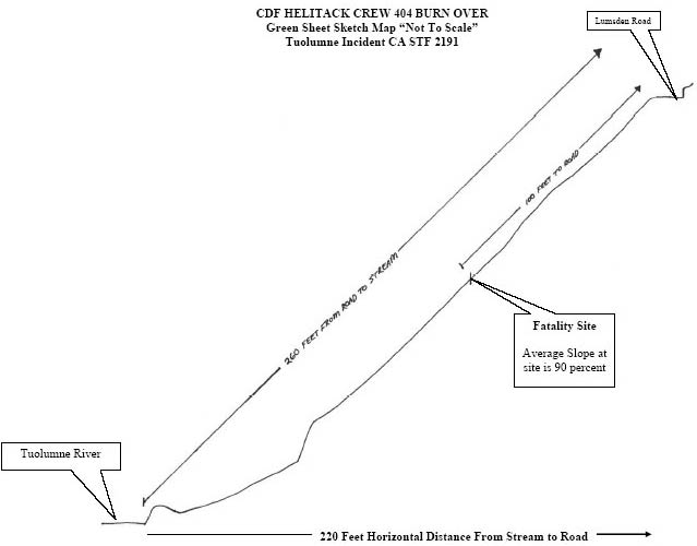
On September 12, 2004 at approximately 1345 hours seven members of CDF Columbia Helitack (Helicopter 404) crew were burned over while constructing fireline from Lumsden Road downhill to the Tuolumne River on a steep slope (80-120%). The fire was located near Lumsden Bridge in the bottom of the Tuolumne River Canyon. The crew had been dropped off by Copter 404 on a gravel bar in the river approximately ¾ mile downstream from the fire. The crew met the incident commander (IC) on Lumsden Road before reaching the fire. The helitack captain (HC) received a strategy briefing to establish an anchor point on the right flank. He walked to the fire’s edge and assessed the area below the road. (sketched map below )
CDF/CAL FIRE Copter 404 Heli-tac Crew Burnover/LODD Sketch Map
CDF Copter 404 Heli-tac Crew Burnover / LODD Sketch Map
 After discussing the assignment and safety issues, the crew members began constructing indirect handline (7 to 30 feet from the fire’s edge) downhill using a chainsaw and hand tools in an oak overstory with brush fuels. 

The fire was backing into an up-canyon wind. A wind shift occurred causing the fire to change direction and spread upslope into the crew. Three members of the crew simultaneously shouted the alarm. 

All members of the crew ran toward identified safety zones. 

Four members of the crew, including the captain, went down to the river; three went up toward Lumsden road.

 The four firefighters (FF) that went downhill reached their safety zone. Of the three firefighters that went uphill, FF#1 and FF#2 made it to the road. FF#3 was last seen by FF#2 immediately behind him approximately 5 feet from the road. FF#3 did not reach the road. Firefighters on-scene estimated the elapsed time from the wind shift to the burn-over was less than 30 seconds with the total wind event lasting less than 2 minutes. Fire shelters were not deployed.

 After reaching the safety zones a crew count determined that FF#3 was missing; an immediate search was begun. FF#3 was located; she was obviously deceased.

The other helitack firefighters received minor to moderate injuries. They received immediate assistance at the scene and were transported to medical facilities in Modesto and Sonora.

CONDITIONS
 The fire location is in Tuolumne County at the bottom of the Tuolumne River Canyon (1450’ elevation) about three (3) miles east of Groveland, California. The Tuolumne River Canyon is a major Sierra Nevada river drainage that has very steep canyon sides and is 2,000 feet deep at the accident site. The fire originated near the river ¼ mile downstream of the Lumsden Bridge.

 The fire was first reported by The Stanislaus National Forest (STF) Duckwall Lookout at 1233 hours. STF dispatched a standard wildland fire response. Copter 404 was dispatched to the fire at 1245 hours from their home base in Columbia, California (22 miles northwest of the fire). CDF Air Attack 440, 2 airtankers, and the IC were already at the scene upon the arrival of Copter 404 at approximately 1305 hours. 

CDF(CAL FIRE) HELITACK 404 CREW 2004
CDF HELITACK 404 CREW 2004 

Copter 404 is a UH-1H Super Huey (type 2) helicopter with a crew of nine, consisting of a pilot, two helitack captains, and six firefighters. After dropping off one helitack captain and six firefighters at a landing zone (LZ) about ¾ mile southwest of the fire, the pilot and one helitack captain remained with the copter and began making water drops up the right flank. At the time of the burn over Copter 404 was working a spot fire off the left flank of the fire.

 The crew walked along the road from the LZ to the right flank of the fire (the fire was burning above and below the road). The helitack captain met the IC at Lumsden Road near South Fork Campground and received a briefing on fire conditions and proposed strategy to anchor the right flank. The crew continued up the road to the right flank, evaluated the situation and the proposed assignment to anchor the right flank at the river.

 Lumsden road parallels the river. The slope distance is approximately 260 feet from the road down to the river at the accident site. The fire was burning upslope from the river with minimal lateral spread on the right flank. The right flank was backing into a light up-canyon wind with flame lengths of less than 12 inches.


FUEL
 During the initial attack, the fire was spreading in light, flashy surface fuels. The fuels were predominately live oak leaf litter, light grass, and mixed brush, with an oak overstory consistent with Fuel Model 2. One- hour fine dead fuel moisture was estimated at 4-5%. Live fuel moisture values at the accident site were unavailable and no representative values were available at the time of this report.

TOPOGRAPHY
The Tuolumne River Canyon is characterized by a meandering river channel with numerous tributary canyons and ridges with slopes ranging from 80-120%. The fire started below Lumsden Road on the south side of the river (north facing slope).

WEATHER

Temperature:89-94 F
Relative Humidity:18-24 %
Wind:Predominately steady up-canyon, estimated 3-5 mph (generally WSW). Prior to the burn-over numerous observers (AA, C404 pilot, IC, crew 404) reported that the wind had remained light and steady flowing in an up-canyon direction.
No critical fire weather patterns (thunderstorms, frontal passage, etc.) were in place.
CDF/CAL FIRE Copter 404 Heli-tac Crew Burnover/LODD Sketch Map

SEQUENCE OF EVENTS
The tactic selected to establish the anchor at the river was indirect line construction to take advantage of sparse fuel and natural barriers. Five backpack pumps were staged on the edge of the road. 
 The crew began using one chainsaw and handtools to construct line downhill from the road to the end of the vegetation (slope distance of 180 feet). The fire was backing into an up-canyon wind.
 The initial point of the handline was approximately 7 feet from the fire’s edge at the road; as the handline progressed, the distance from the edge of the fire widened to approximately 30 feet. After line construction began the firing out operation started. At approximately 1345 hours an abrupt wind shift occurred.
 The 90-120 degree windshift changed the fire spread from a cross-slope backing fire to an upslope head fire. 
The wind event triggering the flare-up lasted less than 2 minutes and the actual flare-up lasted approximately 30 seconds; then fire behavior returned to a backing fire influenced by the up-canyon wind.
The crew’s tool order consisted of FF#6 (chainsaw), FF#5 (swamper), helitack captain (HC) with scraping tool, FF#4 (scraping tool), FF#3 (scraping tool), FF#2 (scraping tool, fusee, and handie talkie ), and FF#1 (back pump). The chain saw cut line extended approximately 120 feet and the scraped portion extended approximately 40 feet. At this point FF #2 had fired out approximately 10 feet of line.
 The HC directed FF#1 to retrieve a backpack pump to support the firing operation. FF#1 returned to the road to put on the backpack pump.
 FF#2 stopped firing and was standing next to FF#3. STF Engine 43 had arrived at a turn-around on Lumsden Road down canyon ¼ mile from the accident site.
 The captain and a firefighter from Engine 43 walked the road from the turnaround to the right flank and arrived seconds prior to the burn over.
FF#5 noticed a wind shift and saw a sheet of fire coming upslope toward him and yelled to FF#6 to go downhill. Simultaneously FF#2 warned of the wind shift and turned uphill along with FF#3 and began escaping up to the road (approximately 20 to 30 feet away). HC yelled a warning; FF#4 saw a hole in the flames and ran downhill through the fire followed by the HC.
FF#1 heard yelling and turned to face the hand line. He saw a run of fire heading up the hand line and yelled for the crew to get out of there.
 FF#1 saw the lower crew members scattering downhill. FF#2 rolled over the lip of the road within the oncoming flame front as the fire hit the road. Although FF#2 and FF#3 were together within 5 feet of the road, FF#3 did not arrive at the road.
FF#1 ended up on the road to the southwest toward STF Engine 43; FF#2 rolled into the inside cutbank of the road, jumped up and ran into the black staying on the road. After going through the flames, FF#4 rolled down the steep rocky embankment toward the river. HC, FF#5, and FF#6 ended up in the safety area at the river. During this event the STF engine 43 captain and firefighter backed off toward the turn-around.
HC identified FF#4, FF#5, and FF#6 along the river and contacted FF#2 by radio. The two separate groups did a crew count and discovered that FF#1 and FF#2 were accounted for and FF#3 was missing.
 They began an immediate search and called for bucket drops and assistance in the search. Copter 404 responded from the spot fire on the left flank, refilled the bucket near Lumsden Bridge, and flew ½ mile west to the accident site. When Copter 404 arrived, the fire behavior had subsided to its previous backing condition.
 Copter 404 began making bucket drops to cool the area so the search could proceed. As the heat and smoke conditions subsided HC, FF#1, FF#2, FF#5, and FF#6 began a grid search.
 Engine 43 arrived at the right flank to assist in the search. As the smoke cleared and bucket drops cooled the area, the searchers discovered the body of FF#3 located in the newly burned area approximately 100 feet below the road.
Injuries
· HC had minor burns to the head and face.
· FF#1 had no reported physical injuries.
· FF#2 was treated for smoke inhalation and minor burns.
· FF#3 was deceased.
· FF#4 was treated for one fractured ankle and one broken rib; one twisted ankle, and abrasions.
· FF#5 had no reported physical injuries.
· FF#6 had no reported physical injuries.

All surviving crew members were transported to hospitals for observation and treatment.

Safety Issues for Review
· 10 Standard Orders
· 18 Situations that Shout Watch Out
· LCES
· Downhill Line Construction Guidelines.
MAPs came with the 24hr Greensheet.
LCES - 10 Standard Fire Orders - 18 Watchout Situations 

Twitter Buttons

****REMINDER**** Every fire has the ability to be catastrophic. The wildland fire management environment has profoundly changed. Growing numbers of communities, across the nation, are experiencing longer fire seasons; more frequent, bigger, and more severe, fires are a real threat. Be careful with all campfires and equipment.

"I am a firm believer in the people. If given the truth, they can be depended upon to meet any national crisis. The great point is to bring them the real facts, and beer." --Abraham Lincoln

View blog top tags
---------------------
CLICK HERE TO GO BACK TO TOP OF CALIFORNIA FIRE NEWS HOME PAGE

Subscribe via email to California Fire News - Keep track of Cal Fire News

Enter your email address:

Delivered by FeedBurner