Sunday, October 25, 2009

CA-CZU- Loma - Wildland Fire - 485 acres, 100% Contained - Mount Modonna

Loma Fire - Santa Cruz Mountains -

View CA-CZU- Loma - Wildland Fire in a larger map
Map courtesy North Tree Fire and U.S.G.S.
YouTube Video Loma Fire
Summit - Loma Fire in Santa Cruz - 10-25-09
Credit: Dan Dawson via Flickr

EVACUATIONS - Mandatory evacuations lifted that were in effect for the areas of Ormsby Cutoff and Highland Way. About 85 structures are threatened.

Road Closures: Maymens Flat Rd, Highland Way, Ormsby Cut, Loma Prieta, Mt. Madonna, Spanish Ranch.

Weather:
CAZ511-512-261130-
EAST BAY HILLS AND DIABLO RANGE-SANTA CRUZ MOUNTAINS-
422 AM PDT SUN OCT 25 2009
.TODAY...
SKY/WEATHER.........PARTLY CLOUDY. PATCHY FOG IN THE MORNING.
MAX TEMPERATURE.....72-81.
24 HR TREND......4 DEGREES COOLER.
MIN HUMIDITY........25-35%.
24 HR TREND......10% DRIER.
20-FOOT WINDS.......
VALLEYS/SLOPE....NORTHWEST WINDS 5 TO 10 MPH.
RIDGE TOPS.......NORTH WINDS 5 TO 10 MPH WITH GUSTS TO AROUND 30
MPH.
CWR (>0.10).........0%.
LAL.................1.
MARINE LAYER........500 FT ASL.

.TONIGHT...
SKY/WEATHER.........CLEAR.
MIN TEMPERATURE.....53-62.
24 HR TREND......4 DEGREES WARMER.
MAX HUMIDITY........53-73%.
24 HR TREND......35% DRIER.
20-FOOT WINDS.......
VALLEYS/SLOPE....NORTHWEST WINDS 5 TO 10 MPH.
RIDGE TOPS.......NORTH WINDS 5 TO 10 MPH WITH GUSTS TO AROUND 30
MPH.
CWR (>0.10).........0%.
LAL.................1.
MARINE LAYER........500 FT ASL.

.MONDAY...
SKY/WEATHER.........SUNNY.
MAX TEMPERATURE.....72-81.
MIN HUMIDITY........25-35%.
20-FOOT WINDS.......
VALLEYS/SLOPE....NORTHWEST WINDS 5 TO 10 MPH.
RIDGE TOPS.......NORTHWEST WINDS AROUND 5 MPH. GUSTS UP TO 30
MPH IN THE MORNING.
CWR (>0.10).........0%.
LAL.................1.

.EXTENDED...
.MONDAY NIGHT...COLDER. MOSTLY CLEAR. WEST WINDS 10 TO 20 MPH WITH
LOCAL GUSTS TO 30 MPH. LOWS IN THE MID 40S TO LOWER 50S.
.TUESDAY...COOLER. MOSTLY CLEAR. NORTHWEST WINDS 15 TO 25 MPH WITH
LOCAL GUSTS TO 45 MPH. LOWS IN THE 40S TO LOWER 50S. HIGHS IN THE
50S TO UPPER 60S.
.WEDNESDAY...MOSTLY CLEAR. NORTH WINDS 10 TO 20 MPH WITH LOCAL GUSTS
TO 40 MPH IN THE MORNING. LOWS IN THE UPPER 30S TO MID 40S. HIGHS
IN THE 50S TO UPPER 60S.
.THURSDAY...MOSTLY CLOUDY. A CHANCE OF RAIN. WEST WINDS AROUND
5 MPH. LOWS IN THE 40S. HIGHS IN THE 50S TO UPPER 60S.

Update: 07214 10-27 - 485 acres. 75% - SCU Cal Fire Battalion Chief Darrell Wolf admits possibility that CDF started the #LomaFire.
Update: 0714 10-26 NOPS GACC - The Loma Incident, CA-SCU, is 600 acres with 20 percent containment.
This fire is under the command of Morris' Type 1 Team, with over thirty years of firefighting experience Chief George Morris Jr. has commanded some of the state’s largest and most complex emergencies.
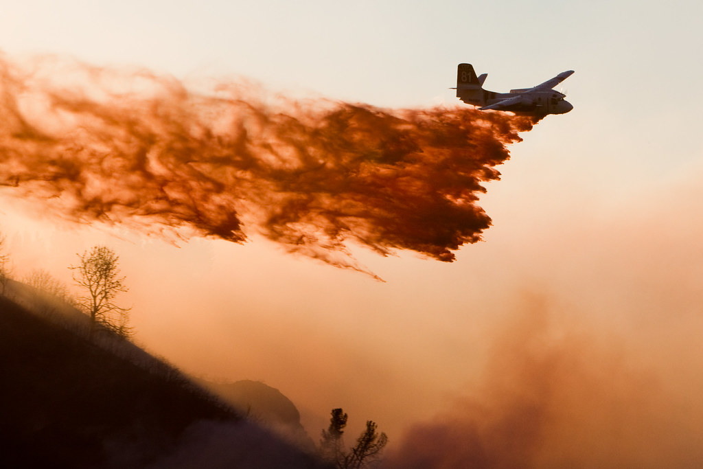
Update: Noon - Per CAL FIRE 800 acres - 0% containment, 100 engines(25 CAL FIRE), 26 Crews, 12 dozers, 6 water tenders, 8 AT's, 5 copters
Strike Team (9110c) engine involved in Hit-Run non injury MVA in Oakland, other veh. took off
Update: 1130 hours - 800 acres, CAL Fire Team 3 (Morris) to transition this evening at 2000 hours.
Fixed wing still grounded (1130 hours), wind has increased to steady 20 with gusts to 50. 10 to 12 Golf ST requested.
Update: 1100hrs ICP currently being set up at Santa Cruz County Fair Grounds.
0630 local Command and Operations agreed that this fire will need a command team for logistic reasons, They are anticipating 4-5 days.
Update: 0900hrs 600+ acres, CAL FIRE Team 3 (Morris) is ordered. Aircraft resuming flights. Still fairly strong north winds at 30 MPH.
Update: 0800hrs - 400 acres, Mandatory evacuations were in effect for the areas of Ormsby Cutoff and Highland Way. About 85 structures are threatened, she said.
Update: 0700hrs - 300+ acres, *Evacuations* - Hundreds being evacuated this morning due to a wildfire burning in the Santa Cruz Mnt. area. Temporary Flight Restriction in effect for media aircraft over the fire.
Update: 0500hrs - 100+ acres, high winds, heavy fuels.
Update: 0330hrs - Summit IC - 5ac mod rate of spread, Fire has now burned thru a canyon burning up the other side of the canyon.

IA: Aprrox 0424hrs - E1768 reporting a 3 acre fire throwing spots down the hill, heavy fuel,
requesting a full wildland response Loma Prieta Wy x. Summit Rd./Mt.
Madonna Rd. Santa Clara/Santa Cruz County Line
Comms: TAC4 and TAC 2 are tactical, air show is on Air Tactics 5, Air Victor is 134.875, CMD 1 151.355, SCU Local 151.455 and CZU Local 151.370, CZU Sheriff RED 154.950
Location: Lat/Long is 37° 5'49.07"N 121°50'46.82"W
Staging at Burrell Station on Summit Rd.
Webcam: CZU- webcam: http://morganhillweather.co...
Resources: Large resource orders, dozers, and crews.
100 engines(25 CAL FIRE), 26 Crews, 12 dozers, 6 water tenders, 8 AT's, 5 copters
Casa Loma Volunteers Paged
B1613 E1663 E1672 E1762 E1768 E1673
TD1640 TD1744
ST9270L
2 Ben Lomond Crews
#LomaFire on Twitter
Cooperating Agencies: CAL FIRE, Santa Cruz County FD, Santa Cruz County Sherrif's Office, CHP, Office of Emergency Services and Dept. of Corrections and Rehabilitation
More information
Phone Numbers:
(831) 335-6717 (Loma Fire Media Line)
(831) 335-6718 (Loma Fire Information )
CAL FIRE website Info: Link

Thursday, October 22, 2009

*High Surf Advisory* Central Calif Coast - Long period High energy Northwest Swell

[EDIS] *High Surf Advisory* Central California Coast - Remains in effect until 11 pm pdt this evening.

Event:
COASTAL HAZARD MESSAGE
Levels: Future - Severe - Possible
Expires: 23:00 PDT on 2009-10-22
From: NATIONAL WEATHER SERVICE SAN FRANCISCO BAY AREA
Headline: HIGH SURF ADVISORY REMAINS IN EFFECT UNTIL 11 PM PDT THIS EVENING

Description: A LONG PERIOD HIGH ENERGY NORTHWEST SWELL TRAIN IS FORECAST TO IMPACT THE CENTRAL CALIFORNIA COASTLINE EARLY THURSDAY MORNING TO THURSDAY NIGHT. A LONG PERIOD HIGH ENERGY NORTHWEST SWELL WILL ARRIVE AT THE CENTRAL CALIFORNIA COASTLINE TODAY AND PRODUCE DANGEROUS BREAKING WAVES WITH HEIGHTS AS HIGH AS 13 TO 16 FEET. THESE WAVES WILL CAUSE HAZARDOUS CONDITIONS NEAR THE SHORE THROUGH LATE TONIGHT. SURFERS AND BEACH GOERS SHOULD BE EXTRA CAUTIOUS NEAR THE SHORELINE AS THESE WAVES ARE EXPECTED TO BE RELATIVELY STRONG AND CAPABLE OF GENERATING STRONG LOCALIZED RIP CURRENTS.

Instruction:
A HIGH SURF ADVISORY MEANS THAT HIGH SURF WILL AFFECT BEACHES IN THE ADVISORY AREA...PRODUCING RIP CURRENTS AND LOCALIZED BEACH EROSION.

Area: SAN FRANCISCO-COASTAL NORTH BAY... INCLUDING POINT REYES NATIONAL SEASHORE-SAN FRANCISCO PENINSULA COAST-NORTHERN MONTEREY BAY-SOUTHERN MONTEREY BAY AND BIG SUR COAST-

Affected Counties or parts of: San Francisco, Santa Cruz, San Mateo, Marin, Monterey, Contra Costa, Napa, San Benito, Sonoma, Santa Clara, Alameda

Wilder Ranch State Park VMP - Santa Cruz / Scotts Valley

Wilder Ranch State Park began a series of "vegetation management burns" on Monday that will continue for two weeks.

When: Burning will take place on various days during the next two weeks depending on weather conditions, available resources and local fire activity.

Closures: Some trails in the park may be closed briefly during the burns.

Smoke: Heavy smoke from the controlled burns at Wilder Ranch State Park drifted through Scotts Valley yesterday.

Why: Controlled burns are one of the tools used to help maintain habitats and reduce of fire hazards.

For more information: California State Parks Department - 335-6318.

Wednesday, October 21, 2009

2007 Firestorm: Rice, Harris Fire, Witch, Guejito and Rice fires

Today in San Diego History - 2007 Firestorm: The Rice, Harris Fire, Witch, and Guejito fires burned northwest from near the border into San Diego, Burnig 350,000 acres and leaving in it's wake 10 people Dead, 350,000 acres and nearly 500,000+ people evacuated.
and more than 1,300 homes were destroyed by the fires.

Sierra Conservation Center inmate pleads guilty to Arson

Inmate pleads guilty to fire at ‘Big Whiskey’

A Sierra Conservation Center inmate who escaped from prison in July 2008 and set fire to a landmark home in Jamestown faces up to eight additional years in prison after he pleaded guilty Monday to arson and escape.

George Landecho Lopez, 36, entered his plea as part of an agreement with the Tuolumne County District Attorney’s Office.

Under the deal, Lopez faces up to eight years for escaping from custody by force and arson of an inhabited structure, Deputy District Attorney John Hansen said. Lopez will also have to register as an arsonist.

The DA dropped three other counts —first degree residential burglary, burglary and receiving stolen property, as part of the agreement. He could have faced nine years and eight months in prison if found guilty on all charges, according to Hansen.

Lopez will be sentenced at 1:30 p.m. Nov. 16 in Department 1 of the Tuolumne County Superior Court.

Lopez was slated for trial Oct. 28.

He pleaded not guilty at his first arraignment July 31 but had the option to change his plea Aug. 31, or take an eight-year cap deal offered by the District Attorney’s Office.

However, on Aug. 31 Lopez maintained that he was not guilty and a trial was scheduled.

The Tehama County resident escaped from a carpentry shop on July 16, 2008, by cutting a fence. On July 18, 2008, he burned down a large house at 6900 O’Byrnes Ferry Road that Clint Eastwood stayed at while filming the movie “Unforgiven.”

Eastwood dubbed the home “The Big Whiskey.”

The fire also destroyed a vast collection of antiques in the home at the time, appraised at about $500,000, homeowner Kari Faughnan has said.

Lopez was captured July 22, 2008. He was found hiding in a vacant firehouse in Chinese Camp. He was found with jewelry and an antique gun belonging to Faughnan, and wearing clothing taken from her home, court documents said.

Lopez has prior convictions in Imperial County for possession of marijuana for sale, and in Tehama County for being a felon in possession of a firearm, failing to appear while on bail, and evading an officer, court documents said.

Faughnan and her estranged husband, Steven Faughnan, sued Sierra Conservation Center Aug. 26 in the Tuolumne County Superior Court seeking $2 million in damages.

The suit claims SCC was obligated to search the area surrounding the prison for 72 hours but called the search off after only 24 hours.

The suit further alleges the Faughnan home is included in a checklist of mandatory homes surrounding the prison to be searched, but it was not.

Kari Faughnan said Monday she was happy Lopez pleaded guilty so she can begin to move on.

“The one thing I keep saying, you could build me 10 houses, you can’t give me back what was lost in the fire. It wasn’t replaceable,” Faughnan said, adding that both she and her son have seen a counselor since the fire.

Faughnan said many community members reached out to her family and that sheriff’s and fire investigators were exceptionally supportive.

“When it comes to him (Lopez), I’m just trying to find a place in my heart where I can forgive him ... and just move on with my life,” Faughnan. “I’m just so happy we don’t have to sit through five days of trial.”

Source: Union Democrat - Link

2003 Old Fire: Suspect indicted - Five counts of murder

A San Bernardino County grand jury indicted Rickie Fowler on five counts of murder in connection with a 2003 wildfire that resulted in the deaths of six people in the path of the blaze, The Los Angeles Times reported.

If convicted Fowler could face the death penalty, prosecutors said.

The investigation as been ongoing since the first day, but gained steam last year, and then new evidence surfaced a few weeks ago.

Prosecutors had until Sunday to file arson charges – that’s when the statute of limitations would have run out.

Fowler has been jailed since 2003 on robbery charges, district attorney Michael Ramos said.

Several witnesses told authorities ahead of the blaze that they saw a man they believed was tossing lit matches out of his truck in the area.

Investigators say Rickie Fowler and another man were seen driving a white van along the road where the “Old Fire” began, and one of them threw a road flare into dry brush. The man Fowler allegedly was with that day was shot and killed three years ago.

The fire burned 90,000 acres, destroyed a thousand homes near two mountain resorts, and led to the heart attack deaths of five people, the youngest of whom was 54. Because the deaths occurred as a result of arson, Fowler could face the death penalty, if he’s convicted. He’s currently serving time for an unrelated burglary conviction.

Earthquake - 3.3 M - Mt. San Gorgonio, CA


A minor earthquake occurred at 6:17:16 AM (PDT) on Wednesday, October 21, 2009.
The magnitude 3.3 event occurred 8 km (5 miles) W of Mt. San Gorgonio, CA.
The hypocentral depth is 8 km ( 5 miles).


Magnitude 3.3 - local magnitude (ML)
Time Wednesday, October 21, 2009 at 6:17:16 AM (PDT)
Wednesday, October 21, 2009 at 13:17:16 (UTC)
Distance from Mt. San Gorgonio, CA - 8 km (5 miles) W (280 degrees)
town of Big Bear Lake, CA - 15 km (9 miles) S (180 degrees)
Yucaipa, CA - 16 km (10 miles) NE (54 degrees)
San Bernardino, CA - 35 km (22 miles) E (93 degrees)
Los Angeles Civic Center, CA - 123 km (77 miles) E (87 degrees)
Coordinates 34 deg. 6.8 min. N (34.113N), 116 deg. 54.6 min. W (116.911W)
Depth 7.6 km (4.7 miles)
Location Quality Good
Location Quality Parameters Nst=125, Nph=125, Dmin=3 km, Rmss=0.27 sec, Erho=0.2 km, Erzz=0.7 km, Gp=18 degrees
Event ID# ci10483781

Tuesday, October 20, 2009

Backbone Incident: OSHA issues USFS "Serious" and "Willfull" violation notice

The Backbone Incident Heli-Base Accident Background

On July 21, 2009 Thomas Marovich, 20, of Hayward California incurred fatal injuries when he fell while performing routine rappel proficiency skill training at the Backbone fire Helibase in Willow Creek, California.

As reported at California Fire News National Forest Service Firefighter Thomas Marovich, 20, had been taking part in required weekly rappelling training, in which people slide down a rope from a hovering helicopter when he fell about 200 feet to the ground, said Forest Service spokeswoman Robin Cole. FF. Marovich was a second year apprentice firefighter on the Modoc National Forest, she said. He was working with the Chester Helitack Crew from the Lassen National Forest that had been assigned to the Backbone Fire in the Trinity Alps Wilderness.

The training was a routine part of the ongoing battle to contain the Backbone Fire, a Forest Service spokesman said. The training is conducted at least every 14 days, he said. The death is being investigated by a Forest Service accident investigation team and the National Transportation Safety Board.

Now the United States Forest Service(USFS) is in a fight with the Occupational Health and Safety Administration(OSHA) involving the release of the Backbone accident investigation documents.

USFS Charged with "Willful" violation of the Occupational Safety and Health Act. OSHA accuses the USFS failing to provide requested information about the accident. USFS continues to refuse to release documents related to the incident, and responds in writing that they would continue to not comply with OSHA's request.

USFS Charged with "Serious" violation of the Occupational Safety and Health Act.

The serious violations involving the unsafe methods and procedures for the use of the rappel equipment, was an somewhat expected development as problems were identified early after the fact with the securing of specific rappelling equipment.

See the whole document at: Google Document: Link

More information:

Related California News Posts: Fatal Accident During Routine Training at The Backbone Helibase

http://calfire.blogspot.com/search/label/Backbone%20Incident

Sunday, October 18, 2009

Earthquake - 3.3 M - Spring Garden, CA


A minor earthquake occurred at 8:47:29 AM (PDT) on Sunday, October 18, 2009.
The magnitude 3.3 event occurred 7 km (4 miles) S of Spring Garden, CA.
The hypocentral depth is 3 km ( 2 miles).


Magnitude 3.3 - local magnitude (ML)
Time Sunday, October 18, 2009 at 8:47:29 AM (PDT)
Sunday, October 18, 2009 at 15:47:29 (UTC)
Distance from Spring Garden, CA - 7 km (4 miles) S (181 degrees)
Greenhorn, CA - 8 km (5 miles) SSW (212 degrees)
Cromberg, CA - 8 km (5 miles) WSW (252 degrees)
Susanville, CA - 65 km (40 miles) SSW (192 degrees)
Sacramento, CA - 155 km (96 miles) NNE (22 degrees)
Coordinates 39 deg. 50.7 min. N (39.846N), 120 deg. 47.9 min. W (120.798W)
Depth 3.3 km (2.1 miles)
Location Quality Fair
Location Quality Parameters Nst= 39, Nph= 39, Dmin=13 km, Rmss=0.09 sec, Erho=0.2 km, Erzz=2.6 km, Gp=72 degrees
Event ID# nc71296155
Additional Information 2-degree map
Google Earth KML (Requires Google Earth.)
Did you feel it?
NCSS First Motion Mechanism 1
Waveforms
Waveforms for ShakeMap

Friday, October 16, 2009

Earthquake - 3.2 M - Oxnard, CA Port Hueneme, CA


A minor earthquake occurred at 9:53:44 PM (PDT) on Friday, October 16, 2009.
The magnitude 3.2 event occurred 6 km (4 miles) ESE of Oxnard, CA.
The hypocentral depth is 2 km ( 1 mile).


Magnitude 3.2 - local magnitude (ML)
Time Friday, October 16, 2009 at 9:53:44 PM (PDT)
Saturday, October 17, 2009 at 4:53:44 (UTC)
Distance from Oxnard, CA - 6 km (4 miles) ESE (111 degrees)
Port Hueneme, CA - 7 km (4 miles) E (80 degrees)
El Rio, CA - 8 km (5 miles) SSE (155 degrees)
Channel Islands Beach, CA - 10 km (6 miles) E (81 degrees)
Los Angeles Civic Center, CA - 81 km (51 miles) W (279 degrees)
Coordinates 34 deg. 10.3 min. N (34.172N), 119 deg. 7.2 min. W (119.120W)
Depth 1.5 km (0.9 miles)
Location Quality Fair
Location Quality Parameters Nst=042, Nph=042, Dmin=9 km, Rmss=0.4 sec, Erho=0.8 km, Erzz=0.6 km, Gp=147.6 degrees
Event ID# ci10482101
Additional Information 2-degree map
Google Earth KML (Requires Google Earth.)
Did you feel it?
Waveforms

Twitter Buttons

****REMINDER**** Every fire has the ability to be catastrophic. The wildland fire management environment has profoundly changed. Growing numbers of communities, across the nation, are experiencing longer fire seasons; more frequent, bigger, and more severe, fires are a real threat. Be careful with all campfires and equipment.

"I am a firm believer in the people. If given the truth, they can be depended upon to meet any national crisis. The great point is to bring them the real facts, and beer." --Abraham Lincoln

View blog top tags
---------------------
CLICK HERE TO GO BACK TO TOP OF CALIFORNIA FIRE NEWS HOME PAGE

Subscribe via email to California Fire News - Keep track of Cal Fire News

Enter your email address:

Delivered by FeedBurner