CAL FIRE Morgan Fire on Mount Diablo 100 percent contained, six days after the blaze began.
#MorganFire, initially reported around 1 p.m. on Sept. 8 off Morgan Territory Rd southeast of Clayton, fully contained at 3,111 acres as of 5:30 p.m., 9-14-13.
Mt. Diablo State Park is set to reopen Monday
 |
| CA-SCU- Morgan Fire Location, Hotspots and Perimeters |
 |
| CA-SCU- Morgan Fire Topo Map Location and Perimeters |
 |
| CA-SCU- Morgan Fire Location, Hotspots and Perimeters |
 |
| Morgan Fire Credit: Empty Duck digital photography Josh Rottman |
 |
| CA-SCU- Morgan Fire Location, Hotspots and Perimeters |
 |
| CA-SCU- Morgan Fire Location and Perimeters |

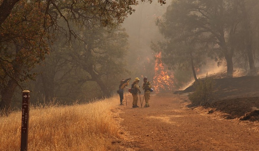 |
| Morgan Fire CALFIRE Crews on the trail
Update 9-14 1830: 3,111 acres, 100% contained. The fire continues the demobilization process of excess resources. Suppression repair continues to make progress.
Update 9-14 0830: 3,111 acres, 95% contained. Expected containment 09/13/2013. Marcucci, ICT3. The Suppression Repair Group continues to make progress. Resource demobilization will continue today. Update 9-13 1830: 3,111 acres, 95% contained. Expected containment 09/13/2013. Marcucci, ICT3. Significant demobilization of resources and closure of base camp is occuring. Suppression repair continues to make progress. Update 9-13 0830: 3,111 acres, 95% contained. Expected containment 09/13/2013. Derum/Patterson, Unified Command. Acreage is lower due to more accurate mapping. Starting today there will be a significant demobilization of resources. The incident is planning transition of command to SCU, at 0700 today. Update 9-12 0830: 3,133 acres, 90% contained. Expected containment 09/13/2013. Derum/Patterson, Unified Command. Ensuring fire stays within established control lines. Aggressive mop-up and tactical patrol. Ensuring all hose and equipment is removed from fire line. Notify fire suppression repair group with any identified areas where repair is needed. The incident is planning transition of command to SCU, 0700 Friday. Update 9-11 1830: 3,133 acres, 80% contained. Derum/Patterson, Unified Command Ensuring fire stays within established control lines. Ensuring all hose and equipment is removed from the fire line. Notify fire suppression repair group with any identified areas where repair is needed. The incident is planning transition of command to SCU, 0700 Friday.Update 9-10 0830: 3,243 acres, 45% contained. Derum/Patterson, Unified Command. High temperatures, low humidity, offshore winds as well as steep slopes are hampering crews in containing the fire. Slow rate of spread, creeping fire. Areas of the fire experienced an increase in fire activity when fire came in alignment with the wind. Fire made slight movement, with some spotting toward Morgan Territory Road which was contained. Helicopter flight improved mapping accuracy. Update 9-9 1830: 3,718 acres, 20% contained. Expected containment 09/14/2013. Derum/Patterson, Unified Command. High temperatures, low humidity, offshore winds as well as steep slopes are hampering crews in containing the fire. Extreme fire behavior and erratic winds contributed to rapid runs in light fuels and spotting. Two very large air tankers assisted with suppression efforts. Evacuations are still in effect. CAL FIRE is in Unified Command with East Contra Costa County Fire Protection District. The East Bay local Type 3 Incident Management Team transitioned to CAL FIRE Type 1 Incident Management Team #4 today.
Update 9-9 1330: 3700+ acres
Update 9-9 1300: 3000+ acres, [NEW MAP] 250 firefighters off lines replaced by 750 new crews, Air Attack has placed order for (2) Very Large Jet engine Airtankers Update 9-9 0700: 1,500 acres, 10% contained. Expected containment 09/14/2013. Jarske/Contra Costa County, Unified Command. Extreme fire behavior observed all night, especially in areas where the winds and terrain are in alignment. Group torching, short crown runs and long range spotting. High temperatures, low humidity, offshore winds as well as steep slopes are hampering crews in containing the fire. The area is in steep inaccessible terrain that has not burned in recent history. The live fuel moistures are at or near critical level. Evacuations in progress, power gird stressed-required reenergizing transmission lines in the fire area. Update 2230: #MorganFire: 800-1000 acres burned, 10% contained, 250 firefighters, 75 structures threatened. Update 1830: 850+ acres, CALFIRE IMT-4 activated. Numerous resource orders, 9252G, 9254G, 9257G enroute, large burn operation planned/proceeding if conditions allow.
Pending at OESR02
1) 2 tactical WT any type
2) 4 Type 3 Charlie S/T
3) 2 INDI
4) Comm Van OES5262
Update 1800: 350+ acres, 10% contained. Jarske/Contra Costa County, Unified Command. High Temperatures, low humidity, offshore winds as well as steep slopes are hampering crews in containing the fire. The fire is in steep terrain that has not burned in recent history. Mount Diablo State Park, Contra Costa County water district watershed area and 500KV electrical transmission lines in the area. The East Bay Incident Management Team is enroute.
Update 1700: East Bay IMT on order 450-500 acres 4 Charlie Strike Teams and 5 more handcrews inbound.
Update 1630: 400 acres - 10% contained, B1613 DIVS of firing group that sounds like they are starting at the top of N. Peak Rd at repeater sites with their firing op and bringing it down hill to Gap Fire Rd on down to heal to contain left flank.
Update 1615: 350 acres, 10-15%, 50-75 structures threatened., Firing DIVS said that its making a hard run to the south and requesting AA to support that. AA estimating 350-400 acres.
Update 1630: IC adding Curry Canyon Rd to the mandatory evac area which is also on left flank of fire.Helicopter-516 from the ENF is on scene.
Update 1600: AA with IC looking at road on left flank (Gap Fire Rd?) for holding and possibly firing from. AA said this would put fire over a "couple thousand acres" if road used. IC asking for CCCSO to start evacs on Oak Hill Ln. which would be consistent with above mentioned road for left flank line
Update 1515: Air Attack estimated it was pushing 350 acres
Update 1500: 170 acres, 10 percent contained. BEU just dispatched ST 9460C immediate need to SCU
Marin County st 9150c enroute.XCC to launch a Type III strike team 2021C, 5011 is the STEN
Update 1430: Per AA open Stockton Reload base,170 acres per IC potential to 300-500.
Update 13:50: 150 acres, plume is visible from the Bay Bridge.
|

Morgan Fire Incident Information:
Last Updated: September 8, 2013 11:40 pm
Date/Time Started: September 8, 2013 1:15 pm
Administrative Unit: CAL FIRE Santa-Clara Unit
County: Contra Costa County
Location: off Morgan Territory Road, Southeast of Clayton
Acres Burned - Containment: 800 acres - 10% contained
Structures Destroyed: 50-75 structures threatened, The fire has burned onto Mt. Diablo State Park.Cooperating Agencies: CAL FIRE, East Contra Costa Fire Protection District, Contra Costa Fire Protection District, San Ramon Valley Fire, East Bay Regional Parks, California State Parks, California Highway Patorl And Contra Costa County Sheriff's Department.
Total Fire Personnel: 360
Total Fire Engines: 41
Total Fire crews: 9
Total Helicopters: 3
Total Dozers: 9
Total Water Tenders: 5
Incident Management Team: East Bay Incident Management Team (Type 3) on order
Conditions: Phone Numbers (408) 201-4378 (Morgan Fire Media Line)
IA Description: -
IA Resources: -
ROC: -
ROS: -
Structure Threats: - Yes about 75 structures
Situation Concerns/Alerts: -
Situation Comments: -
Additional Resource Notes: -
Agency Website: -
Radio Frequencies: -151.160 Cal Fire Tac 2 (simplex)
151.325 Cal Fire Tac 6 (simplex)
151.385 Cal Fire Tac 9 (simplex)
151.355 Cal Fire Command 1 (repeater)
151.310 Cal Fire Airtankers (simplex)
151.220 Cal Fire helicopters (simplex)
122.575 AM Aircraft Air to Air - fixed wing
122.925 AM Aircraft Air to Air - helicopters
Online Scanners: -
Weather: -
Web Cams: -
---------------------------------------------
No comments:
Post a Comment
CAL FIRE NEWS LOVES COMMENTS...
- Due to rampant abuse, we are no longer posting anonymous comments. Please use your real OpenID, Google, Yahoo, AIM, Twitter, Flickr name.